Items Similar to Antique Map of Egypt and the Nile Valley with City Index, 1715


Want more images or videos?
Request additional images or videos from the seller
1 of 10
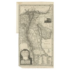
Antique Map of Egypt and the Nile Valley with City Index, 1715
$396.30
£293.52
€330
CA$542.11
A$589.99
CHF 312.75
MX$7,097.98
NOK 3,966.69
SEK 3,629.24
DKK 2,514.66
About the Item
Antique map of Egypt, titled "Essay d'une Carte d'Égypte Fait au Caire en 1715".
This finely engraved map presents a detailed depiction of Egypt along the Nile River from the Mediterranean coast to the region of Nubia, accompanied by extensive side text providing an alphabetical list of towns and notable locations. The map includes Alexandria, Rosette, Damiette, Cairo, and numerous smaller settlements, as well as natural features such as mountains, lakes, and deserts. The Red Sea is shown to the east, with ports and coastal details, while to the west lie oases and desert regions.
Produced in 1715, this map reflects early 18th-century European cartographic knowledge of Egypt, combining geographic accuracy with descriptive annotations. Its creation in Cairo adds historical importance, suggesting firsthand observation or access to local sources. The engraved style, fine hachuring for mountains, and inclusion of river networks give the map both artistic and scholarly value.
As an object of historical interest, this map offers insight into Egypt’s geography before modern surveys, during a period when it was of strategic and cultural interest to European powers. Collectors of antique maps, especially those focusing on North Africa or early 18th-century cartography, will appreciate its rarity and the fact that it dates from before Napoleon’s Egyptian campaign.
Condition: Light toning and some faint creases from folding as issued. Minor foxing in places and waterstains along some borders. Strong impression with excellent detail. Paper remains robust with no significant tears or repairs.
Framing tips: A dark wood or black frame with a cream or light beige mount will highlight the engraving’s fine linework. For a more museum-style display, consider an archival mount with a gold fillet to emphasize the historical character of the piece.
Technique: Engraving
Maker: Unknown, 1715
- Dimensions:Height: 11.82 in (30 cm)Width: 11.82 in (30 cm)Depth: 0.01 in (0.2 mm)
- Materials and Techniques:Paper,Engraved
- Place of Origin:
- Period:
- Date of Manufacture:circa 1715
- Condition:Condition: Light toning and some faint creases from folding as issued. Minor foxing in places and waterstains along some borders. Strong impression with excellent detail. Paper remains robust with no significant tears or repairs.
- Seller Location:Langweer, NL
- Reference Number:Seller: BG-14078-421stDibs: LU3054346219962
About the Seller
5.0
Recognized Seller
These prestigious sellers are industry leaders and represent the highest echelon for item quality and design.
Platinum Seller
Premium sellers with a 4.7+ rating and 24-hour response times
Established in 2009
1stDibs seller since 2017
2,816 sales on 1stDibs
Typical response time: 1 hour
- ShippingRetrieving quote...Shipping from: Langweer, Netherlands
- Return Policy
More From This Seller
View AllAntique Map of The Nile, Egypt and the Red Sea by Bachiene, 1765
Located in Langweer, NL
Antique map titled 'De XIde Landkaart verbeeldende Egypte en de Woestyne der Schelf-Zee (..).' Map of Biblical Egypt and the Red Sea. With title cartouche, compass rose and scale. Th...
Category
Antique 18th Century Maps
Materials
Paper

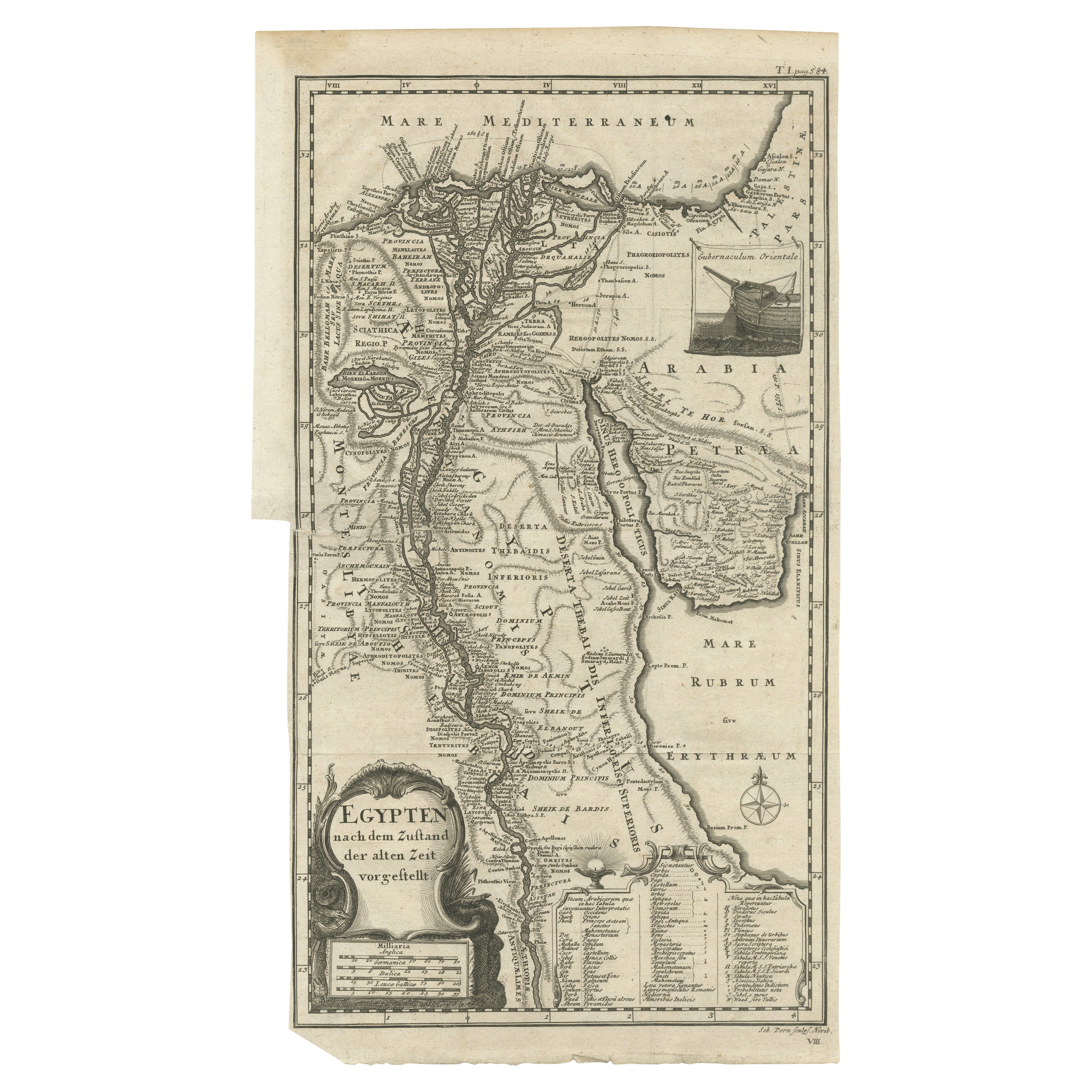
Antique Map of Egypt and the Nile River
Located in Langweer, NL
Antique map titled 'Egypten nach dem Zustand der alten Zeit vorgestellt'. This uncommon and richly detailed map of Egypt features hundreds of place names along the Nile. The Sinai Pe...
Category
Antique Mid-18th Century Maps
Materials
Paper
$326 Sale Price
20% Off
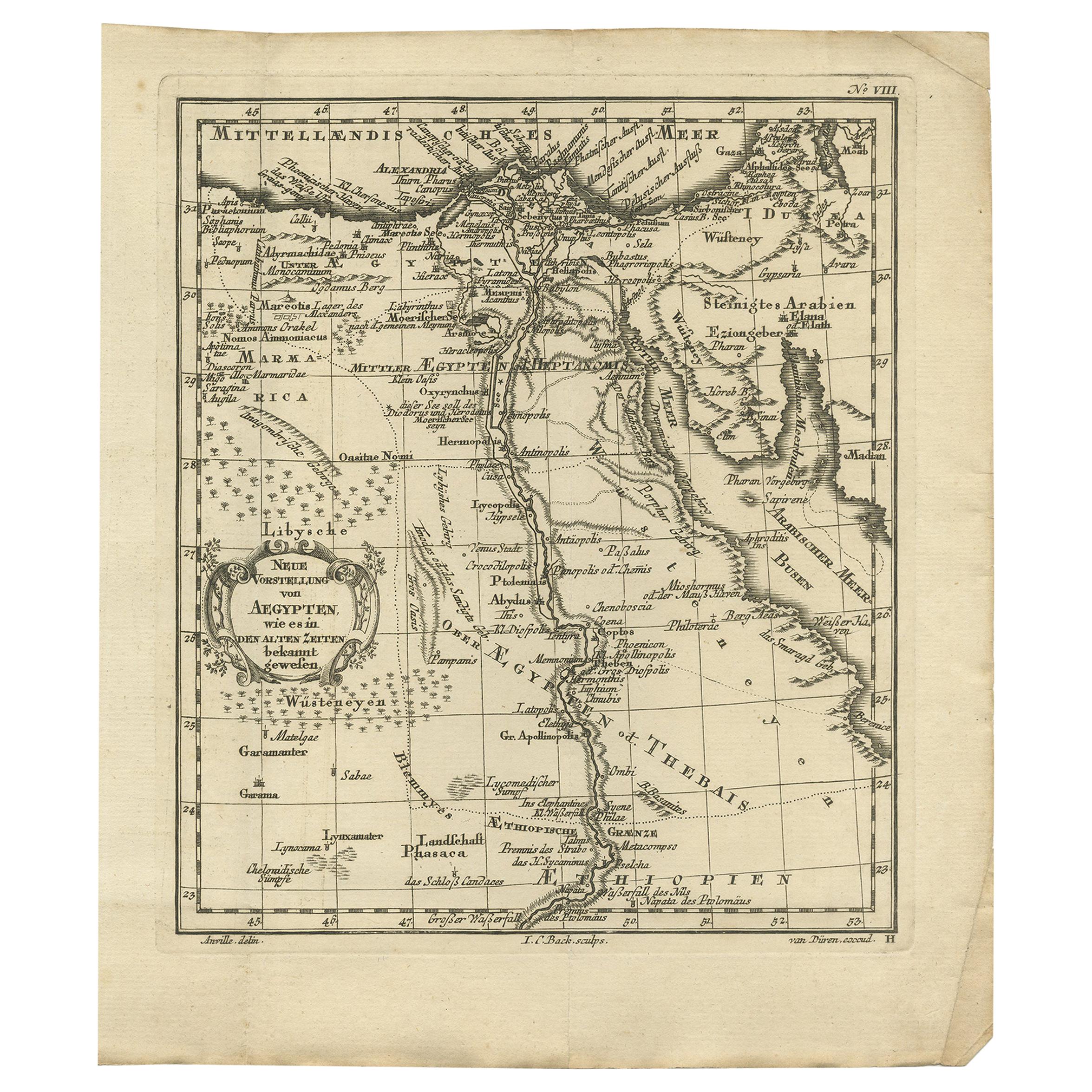
Original Antique Map of Egypt by Van Dùren
1749
Located in Langweer, NL
Decorative German antique engraving with titled 'Neue Vorstellung von Aegypten (..)'. It concerns a rare original antique map of Egypt. This map o...
Category
Antique Mid-18th Century Maps
Materials
Paper

$247 Sale Price
25% Off
Antique Map of Egypt with Detailed Inset of the Nile Delta, ca. 1799
Located in Langweer, NL
Antique Map of Egypt with Detailed Inset of the Nile Delta, ca. 1799
This finely engraved antique map titled Carte Physique et Politique de l’Égypte presents a detailed and scientif...
Category
Antique Early 1800s French Maps
Materials
Paper

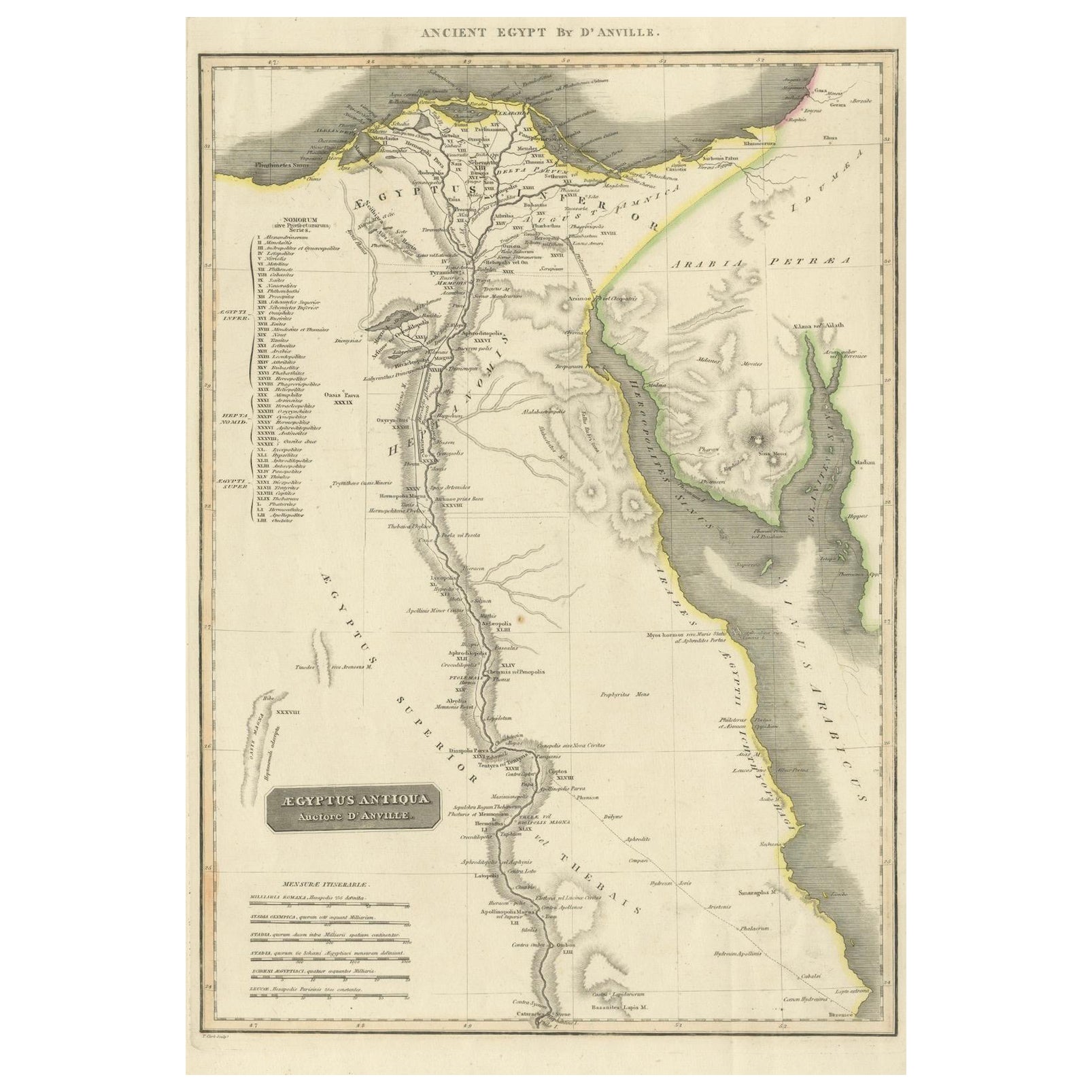
Ancient Egypt – Nile Valley Map by d’Anville, Classical Antiquity, c.1765
Located in Langweer, NL
Ancient Egypt – Nile Valley Map by d’Anville, Classical Antiquity, c.1765
This finely engraved map depicts Ancient Egypt as understood through classical sources, extending along the...
Category
Antique 1760s French Maps
Materials
Paper
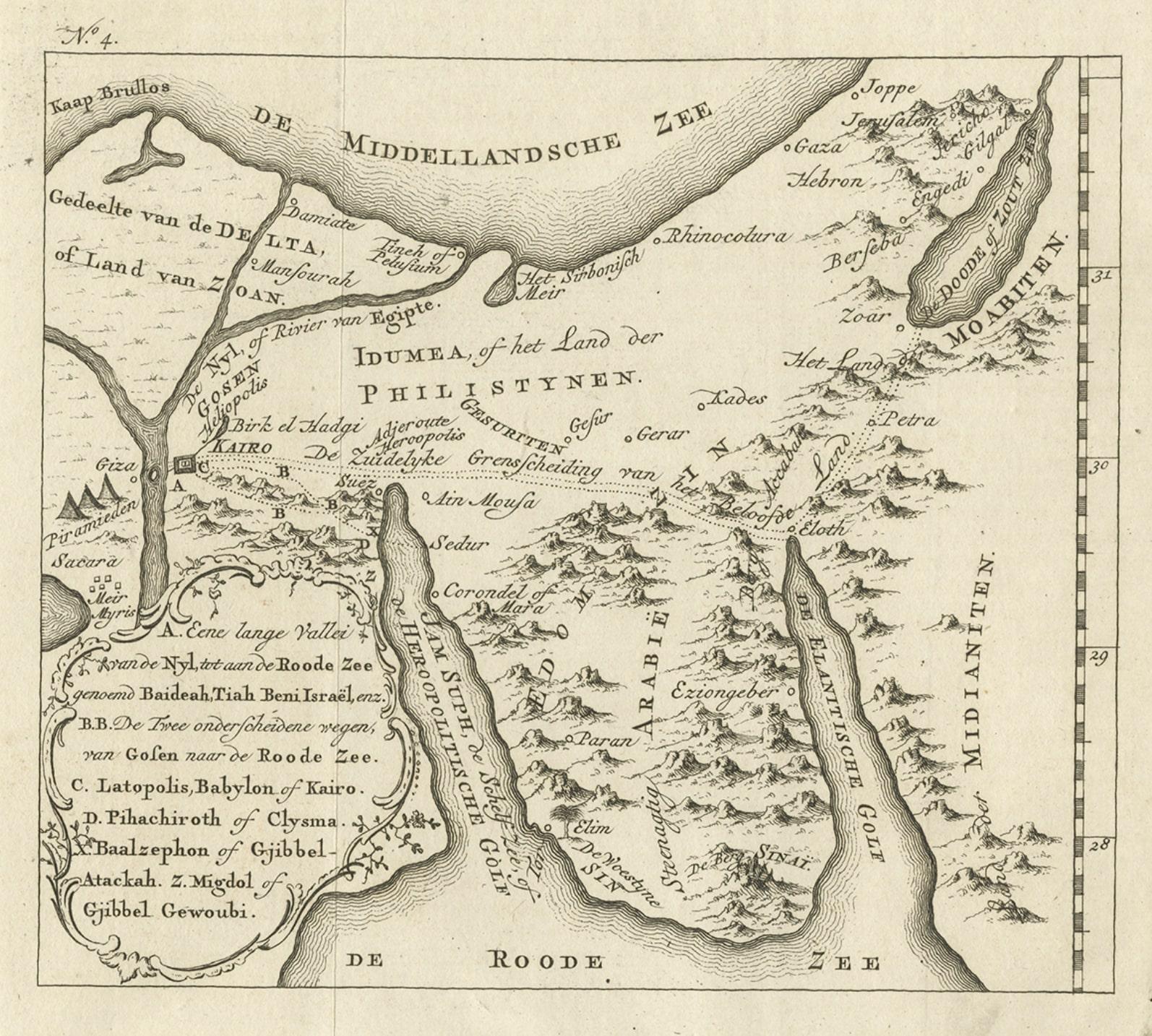
Antique Map of Edom, an Ancient Kingdom in Transjordan, 1773
Located in Langweer, NL
Antique print titled 'Idumea, of thet Land der Philistynen'. Old map of Edom, an ancient kingdom in Transjordan located between Moab to the northeast, the Arabah to the west and the ...
Category
Antique 18th Century Maps
Materials
Paper
You May Also Like
Map of Nubia and Abissinia - Original Etching by Antonio Zatta - 1784
Located in Roma, IT
This Map of Nubia and Abissinia is an etching realized by Antonio Zatta in Venice in 1784.
The state of preservation of the artwork is good expect for the worn paper with some littl...
Category
1770s Landscape Prints
Materials
Etching

Map of the Holy Land "Carte de la Syrie et de l
Egypte" by Pierre Lapie
By Pierre M. Lapie
Located in Alamo, CA
This is an early 19th century map of ancient Syria and Egypt entitled "Carte de la Syrie et de l'Egypte anciennes/dressée par M. Lapie, Colonel d'Etat M...
Category
1830s Landscape Prints
Materials
Engraving

Original Antique Map of Ancient Greece- Boeotia, Thebes, 1787
Located in St Annes, Lancashire
Great map of Ancient Greece. Showing the region of Boeotia, including Thebes
Drawn by J.D. Barbie Du Bocage
Copper plate engraving by P.F T...
Category
Antique 1780s French Other Maps
Materials
Paper

Map of the Holy Land "Carte de la Syrie et de l
Egypte" by Pierre M. Lapie
By Pierre M. Lapie
Located in Alamo, CA
An early 19th century map of ancient Syria and Egypt entitled "Carte de la Syrie et de l'Egypte anciennes/dressée par M. Lapie, Colonel d'Etat Major, et...
Category
Antique Early 19th Century French Maps
Materials
Paper

$620 Sale Price
20% Off
Original Antique Map of Ancient Greece, Achaia, Corinth, 1786
Located in St Annes, Lancashire
Great map of Ancient Greece. Showing the region of Thessaly, including Mount Olympus
Drawn by J.D. Barbie Du Bocage
Copper plate engraving by P.F Tardieu
Original hand color...
Category
Antique 1780s French Other Maps
Materials
Paper

1714 Henri Chatelain "Nouvelle Carte Des Etatas Du Grand.Duc De Mos Moscovie Eur
Located in Norton, MA
A 1714 Henri Chatelain map, entitled
"Nouvelle Carte Des Etatas Du Grand Duc De Moscovie En Europe,"
Ricb001
Henri Abraham Chatelain (1684-1743) was a Huguenot pastor of Parisi...
Category
Antique Early 18th Century Dutch Maps
Materials
Paper

More Ways To Browse
Napoleon Egypt
Antique Furniture Index
1970 Italian Armchair
House Of Denmark Table And Chairs
Louis Marble Top Side Table
Antique Russian Rugs
Baker Furniture By
For Kids
Sterling Silver Flatware Set Service For 12
Tufted Bar
Pair Of French Antique Armchairs
1970s Brass Glass Coffee Table
Antique Column Base
Charles Rennie Mackintosh For Cassina
Glass Salt
Italian Modern Silver Vases
Vintage Resin Tables
Antique English Country Furniture