Want more images or videos?
Request additional images or videos from the seller
1 of 6
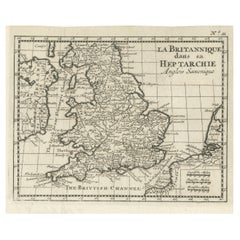
Antique Map of England and Wales Depicting the Period of the Saxon Heptarchy
$423.07List Price
About the Item
- Dimensions:Height: 10.28 in (26.1 cm)Width: 8.39 in (21.3 cm)Depth: 0.02 in (0.5 mm)
- Materials and Techniques:
- Period:
- Date of Manufacture:circa 1770
- Condition:General age-related toning. Minor wear and soiling. Few tiny defects/tears, sl. affecting image. Blank verso. Please study image carefully.
- Seller Location:Langweer, NL
- Reference Number:Seller: BG-13396-231stDibs: LU3054333703592
About the Seller
5.0
Recognized Seller
These prestigious sellers are industry leaders and represent the highest echelon for item quality and design.
Platinum Seller
Premium sellers with a 4.7+ rating and 24-hour response times
Established in 2009
1stDibs seller since 2017
2,813 sales on 1stDibs
Typical response time: 1 hour
Authenticity Guarantee
In the unlikely event there’s an issue with an item’s authenticity, contact us within 1 year for a full refund. DetailsMoney-Back Guarantee
If your item is not as described, is damaged in transit, or does not arrive, contact us within 7 days for a full refund. Details24-Hour Cancellation
You have a 24-hour grace period in which to reconsider your purchase, with no questions asked.Vetted Professional Sellers
Our world-class sellers must adhere to strict standards for service and quality, maintaining the integrity of our listings.Price-Match Guarantee
If you find that a seller listed the same item for a lower price elsewhere, we’ll match it.Trusted Global Delivery
Our best-in-class carrier network provides specialized shipping options worldwide, including custom delivery.You May Also Like
Old Horizontal Map of England
By Tasso
Located in Alessandria, Piemonte
ST/520 - Old rare Italian map of England, dated 1826-1827 - by Girolamo Tasso, editor in Venise, for the atlas of M.r Le-Sage.
Category
Antique Early 19th Century Italian Other Prints
Materials
Paper

Large 17th Century Hand Colored Map of England and the British Isles by de Wit
By Frederick de Wit
Located in Alamo, CA
A large hand colored 17th century map of England and the British Isles by Frederick de Wit entitled "Accuratissima Angliæ Regni et Walliæ Principatus", published in Amsterdam in 1680. It is a highly detailed map of England, Scotland, the Scottish Isles...
Category
Antique Late 17th Century Dutch Maps
Materials
Paper

$940 Sale Price
20% Off
H 35 in W 30.5 in D 2 in
Map of the Republic of Genoa
Located in New York, NY
Framed antique hand-coloured map of the Republic of Genoa including the duchies of Mantua, Modena, and Parma.
Europe, late 18th century.
Dimension: 25...
Category
Antique Late 18th Century European Maps

Antique Map of Principality of Monaco
By Antonio Vallardi Editore
Located in Alessandria, Piemonte
ST/619 - "Old Geographical Atlas of Italy - Topographic map of ex-Principality of Monaco" -
ediz Vallardi - Milano -
A somewhat special edition ---
Category
Antique Late 19th Century Italian Other Prints
Materials
Paper

17th Century Hand-Colored Map of Southeastern England by Mercator and Hondius
By Gerard Mercator
Located in Alamo, CA
A 17th century copperplate hand-colored map entitled "The Sixt Table of England" by Gerard Mercator and Jodocus Hondius, published in Amsterdam in 1635 in 'Cosmographicall Descriptio...
Category
Antique Mid-17th Century Dutch Maps
Materials
Paper

$540 Sale Price
20% Off
H 12 in W 14 in D 0.13 in
Antique Anatomical Wall Chart Depicting the Human Skeleton
Located in Berghuelen, DE
Antique Anatomical Wall Chart Depicting the Human Skeleton
A rare 19th century anatomical wall chart depicting the human skeleton. On the sides On the...
Category
Early 20th Century German Victorian Prints
Materials
Paper

Antique 18th Century Map of the Province of Pensilvania
Pennsylvania State
Located in Philadelphia, PA
A fine antique of the colony of Pennsylvania.
Noted at the top of the sheet as a 'Map of the province of Pensilvania'.
This undated and anonymous map is thought to be from the Gentleman's Magazine, London, circa 1775, although the general appearance could date it to the 1760's.
The southern boundary reflects the Mason-Dixon survey (1768), the western boundary is placed just west of Pittsburgh, and the northern boundary is not marked.
The map has a number of reference points that likely refer to companion text and appear to be connected to boundaries. The western and southern boundaries are marked Q, R, S, for example. A diagonal line runs from the Susquehanna R to the Lake Erie P. A broken line marked by many letters A, B, N, O, etc., appears in the east.
There are no latitude or longitude markings, blank verso.
Framed in a shaped contemporary gilt wooden frame and matted under a cream colored matte.
Bearing an old Graham Arader Gallery...
Category
Antique 18th Century British American Colonial Maps
Materials
Paper

$1,250
H 10.25 in W 13.25 in D 0.5 in
Original Antique Map of The World by Thomas Clerk, 1817
Located in St Annes, Lancashire
Great map of The Eastern and Western Hemispheres
On 2 sheets
Copper-plate engraving
Drawn and engraved by Thomas Clerk, Edinburgh.
Published by Mackenzie And Dent, 1817
...
Category
Antique 1810s English Maps
Materials
Paper

$90 / set
Free Shipping
H 10.25 in W 8.25 in D 0.07 in
Map "Estuary- Mouth of the Thames"
Located in Alessandria, Piemonte
ST/426 - Antique French Map of the estuary of the Thames, map dated 1769 -
"Mape of the entrance of the Thames. Designed by filing of Navy cards fo...
Category
Antique Mid-18th Century French Other Prints
Materials
Paper

Original Antique Map of Ireland- Tipperary and Waterford. C.1840
Located in St Annes, Lancashire
Great map of Tipperary and Waterford
Steel engraving
Drawn under the direction of A.Adlard
Published by How and Parsons, C.1840
Unframed.
Category
Antique 1840s English Maps
Materials
Paper

$35
Free Shipping
H 9.5 in W 6.25 in D 0.07 in
More From This Seller
View AllSmall Antique Map of England and Wales as It Was During the Heptarchy
Located in Langweer, NL
Antique map titled 'La Britannique dans sa Heptarchie Anglois Saxonique'. This little map shows England and Wales as it was during the Heptarchy, a phrase referring to the seven king...
Category
Antique Mid-18th Century Maps
Materials
Paper
$278 Sale Price
20% Off
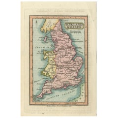
Miniature Antique Map of England and Wales
Located in Langweer, NL
Miniature map titled 'England & Wales'. Original antique map of England & Wales. This map originates from 'Darton's New Miniature Atlas' publis...
Category
Antique Early 19th Century Maps
Materials
Paper
$249 Sale Price
20% Off
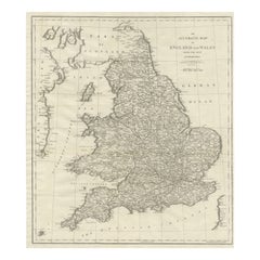
Large Antique Map of England and Wales
Located in Langweer, NL
Antique map titled 'An Accurate Map of England and Wales'. Original old map of England and Wales. Engraved by John Cary. Originates from 'New British Atlas' by John Stockdale, publis...
Category
Antique Early 19th Century Maps
Materials
Paper
$317 Sale Price
20% Off
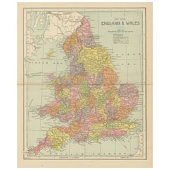
Lithographed Antique Map of England and Wales
Located in Langweer, NL
Original antique map titled 'Map XXIII England & Wales'. Lithographed map of England and Wales. Published by Fisk & See, circa 1890.
Category
Antique Late 19th Century Maps
Materials
Paper
$182 Sale Price
20% Off
Original Antique Map of England and Wales
Located in Langweer, NL
Antique map titled 'A New and Correct Map of England and Wales from the Latest and Best Improvements'. Original antique map of England and Wales. Printed by Alex Hogg, London for George Henry Millar's 'New, Complete and Universal System...
Category
Antique Late 18th Century Maps
Materials
Paper

$230 Sale Price
20% Off
Antique Map of England and Wales, Also Showing the English Channel
Located in Langweer, NL
Antique map titled 'England and Wales'. Original antique map of England and Wales. Drawn and engraved by J. Dower. Originates from 'A General Descriptive Atlas Of The Earth, Containi...
Category
Antique Mid-19th Century Maps
Materials
Paper

$144 Sale Price
20% Off
Still Thinking About These?
All Recently ViewedMore Ways To Browse
1681 Moses Pitt
Antique Map Bermuda
Antique Map Of Brooklyn
Antique Map Of Republic Of Texas
Extra Large Map
George Weymouth
Georgetown Map
Hemisphere Antiques
J Matthews
Japanese Kite
Maltese Falcon
Map Tuscany
St Eustatius
Sumba Map
Used Furniture Denver Co
Used Furniture Leominster
Vintage Long Island Map
Vintage World Map Desk