Want more images or videos?
Request additional images or videos from the seller
1 of 6
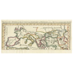
Antique Map of European Trade in Asia by Pluche, 1742
Price:$104.61
About the Item
- Dimensions:Height: 6.3 in (16 cm)Width: 6.7 in (17 cm)Depth: 0 in (0.01 mm)
- Materials and Techniques:
- Period:
- Date of Manufacture:1742
- Condition:
- Seller Location:Langweer, NL
- Reference Number:Seller: PCT-354121stDibs: LU3054326190192
About the Seller
5.0
Recognized Seller
These prestigious sellers are industry leaders and represent the highest echelon for item quality and design.
Platinum Seller
Premium sellers with a 4.7+ rating and 24-hour response times
Established in 2009
1stDibs seller since 2017
2,828 sales on 1stDibs
Typical response time: 1 hour
Authenticity Guarantee
In the unlikely event there’s an issue with an item’s authenticity, contact us within 1 year for a full refund. DetailsMoney-Back Guarantee
If your item is not as described, is damaged in transit, or does not arrive, contact us within 7 days for a full refund. Details24-Hour Cancellation
You have a 24-hour grace period in which to reconsider your purchase, with no questions asked.Vetted Professional Sellers
Our world-class sellers must adhere to strict standards for service and quality, maintaining the integrity of our listings.Price-Match Guarantee
If you find that a seller listed the same item for a lower price elsewhere, we’ll match it.Trusted Global Delivery
Our best-in-class carrier network provides specialized shipping options worldwide, including custom delivery.You May Also Like
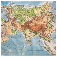
Huge Europe and Asia Vintage Wall Map
Located in San Diego, CA
A huge Europe and Asia vintage wall map, circa 1950s. The map is in fair vintage condition and measures 78"W x 73"H". #2863
Category
Mid-20th Century American Maps
Materials
Paper
Large Original Antique Map of Asia by Sidney Hall, 1847
Located in St Annes, Lancashire
Great map of Asia
Drawn and engraved by Sidney Hall
Steel engraving
Original colour outline
Published by A & C Black. 1847
Unframed
Free shipping
Category
Antique 1840s Scottish Maps
Materials
Paper

$50
Free Shipping
H 12.25 in W 17.25 in D 0.07 in
Original Antique Map of Europe, Arrowsmith, 1820
Located in St Annes, Lancashire
Great map of Europe
Drawn under the direction of Arrowsmith.
Copper-plate engraving.
Published by Longman, Hurst, Rees, Orme and Brown, 1820
...
Category
Antique 1820s English Maps
Materials
Paper

Large Original Antique Map of Europe by Sidney Hall, 1847
Located in St Annes, Lancashire
Great map of Europe
Drawn and engraved by Sidney Hall
Steel engraving
Original colour outline
Published by A & C Black. 1847
Unframed
Free shipping.
Category
Antique 1840s Scottish Maps
Materials
Paper

$50
Free Shipping
H 12.5 in W 17 in D 0.07 in
Original Antique Map of South East Asia by Thomas Clerk, 1817
Located in St Annes, Lancashire
Great map of South East Asia
Copper-plate engraving
Drawn and engraved by Thomas Clerk, Edinburgh.
Published by Mackenzie And Dent, 1817
Unframed.
Category
Antique 1810s English Maps
Materials
Paper

$35
Free Shipping
H 8.25 in W 10.25 in D 0.07 in
Antique French Map of Asia Including China Indoneseia India, 1783
Located in Amsterdam, Noord Holland
Very nice map of Asia. 1783 Dedie au Roy.
Additional information:
Country of Manufacturing: Europe
Period: 18th century Qing (1661 - 1912)
Condition: Overall Condition B (Good Used)...
Category
Antique 18th Century European Maps
Materials
Paper

$486 Sale Price
40% Off
H 21.26 in W 27.56 in D 0.04 in
Antique 1803 Italian Map of Asia Including China Indoneseia India
Located in Amsterdam, Noord Holland
Antique 1803 Italian Map of Asia Including China Indoneseia India
Very nice map of Asia. 1803.
Additional information:
Type: Map
Country of Manufacturing: Europe
Period: 19th centu...
Category
Antique 19th Century European Maps
Materials
Paper

$438 Sale Price
39% Off
H 12.6 in W 15.75 in D 0.04 in
1853 Map of "Russia in Europe Including Poland" Ric.r016
Located in Norton, MA
Description
Russia in Europe incl. Poland by J Wyld c.1853
Hand coloured steel engraving
Dimension: Paper: 25 cm W x 33 cm H ; Sight: 22 cm W x 28 cm H
Condition: Good ...
Category
Antique 19th Century Unknown Maps
Materials
Paper

1870 "Johnson
s Europe" Map Published by A. J. Johnson
Located in Colorado Springs, CO
Presented is an original 1870 "Johnson’s Europe" map. First published in 1864, this map was issued as pages 87 and 88 in the 1870 edition of “Johnson's New Illustrated (Steel Plate) ...
Category
Antique 1870s American Victorian Maps
Materials
Paper

Map Turkey in Europe
Hungary Thomas Kitchin, 1783
Located in BUNGAY, SUFFOLK
Thomas Kitchen (1718 - 1784) : Map of Turkey in Europe & Hungary 1783
Visible sheet within the cream mount 25.5cm., 10" height 20cm., 8"
In an ebonised frame length 33cm. 13", height 28cm., 11"
Kitchin, Thomas (1718 - 1784)
Thomas Kitchin (August 4, 1718 – June 23, 1784) was a London based engraver, cartographer, and publisher. He was born in London to a hat-dyer of the same name. At 14, Kitchin apprenticed under Emanuel Bowen, under whom he mastered the art of engraving. He married Bowen daughter, Sarah Bowen, and later inherited much of his preceptor's prosperous business. Their son, Thomas Bowen Kitchin, also an engraver joined the family business, which thereafter published in Thomas Kitchin and Son. From 1858 or so Kitchin was the engraver to the Duke of York, and from about 1773 acquired the title, 'Royal Hydrographer to King George III.' He is responsible for numerous maps published in the The Star, Gentleman's Magazine, and London Magazine, as well as partnering with, at various times, with Thomas Jefferys, Emmanuel Bowen, Thomas Hinton, Issac Tayor, Andrew Dury, John Rocque, Louis de la Rochette, and Alexander Hogg, among others. Kitchin passed his business on to his son, Thomas Bowen Kitchin, who continued to republish many of his maps well after his death. Kitchin's apprentices included George Rollos...
Category
Antique 18th Century English Georgian Maps
Materials
Paper

More From This Seller
View AllAntique Map of the City of Haarlem by Tirion, 1742
By Isaak Tirion
Located in Langweer, NL
Antique map titled 'Grondtekening van Haarlem (..)'. Original antique map of the city of Haarlem, the Netherlands. Published by I. Tirion, 1742.
Artists and Engravers: Isaak Tirio...
Category
Antique 18th Century Maps
Materials
Paper
Antique Map of Asia by with an Inset Map of Turkey in Asia, 1868
Located in Langweer, NL
Antique map Asia titled 'Carte Politique et Ethnographique d'Asie'. Old map of Asia with an inset map of Turkey in Asia. Includes descriptive text box...
Category
Antique 19th Century Maps
Materials
Paper

Intriguing Antique Map of Europe, Asia and Africa by Scherer, c.1703
Located in Langweer, NL
Two maps on a single sheet showing Europe, Asia and Africa, each depicting nearly the same area. On close examination there are slight differences. Major cities are located. Printed ...
Category
Antique 18th Century German Maps
Materials
Paper
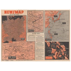
Antique Map of the War Situation in Europe and Asia, 1944
Located in Langweer, NL
Antique map titled 'Newsmap for the Armed Forces'. This "newsmap" was issued on Monday, December 18, 1944, and covers the news from December 6-13, 1945 - the 275th week of the war. T...
Category
20th Century Maps
Materials
Paper
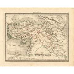
Antique Map of Turkey in Asia
Asia Minor
by Vuillemin, 1846
Located in Langweer, NL
Antique map titled 'Turqui D'Asie'. Map of Turkey in Asia / Asia Minor. This attractive original old antique print / plate / map originates from: 'Atlas Uni...
Category
Antique 19th Century Maps
Materials
Paper
$71 Sale Price
20% Off
Phoenician Trade Routes – Antique Map of Europe and the Mediterranean, 1748
Located in Langweer, NL
Phoenician Trade Routes – Antique Map of Europe and the Mediterranean, 1748
This antique German map titled Vorstellung von Europa zur Erläuterung der Schifffahrt der Phönicier auf d...
Category
Antique Mid-18th Century Maps
Materials
Paper