Items Similar to Antique Map in Frame of the Region of Paris ‘France’ by H. Heirs, circa 1720


Want more images or videos?
Request additional images or videos from the seller
1 of 10
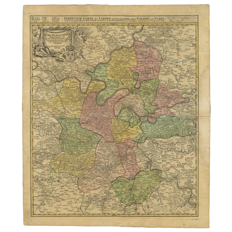
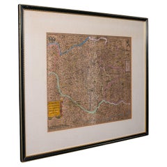
Antique Map in Frame of the Region of Paris ‘France’ by H. Heirs, circa 1720
$1,044.17
$1,305.2120% Off
£779.52
£974.4020% Off
€880
€1,10020% Off
CA$1,450.67
CA$1,813.3320% Off
A$1,560.40
A$1,950.5020% Off
CHF 833.92
CHF 1,042.4020% Off
MX$18,392.68
MX$22,990.8520% Off
NOK 10,513.82
NOK 13,142.2820% Off
SEK 9,611.63
SEK 12,014.5320% Off
DKK 6,706.59
DKK 8,383.2420% Off
About the Item
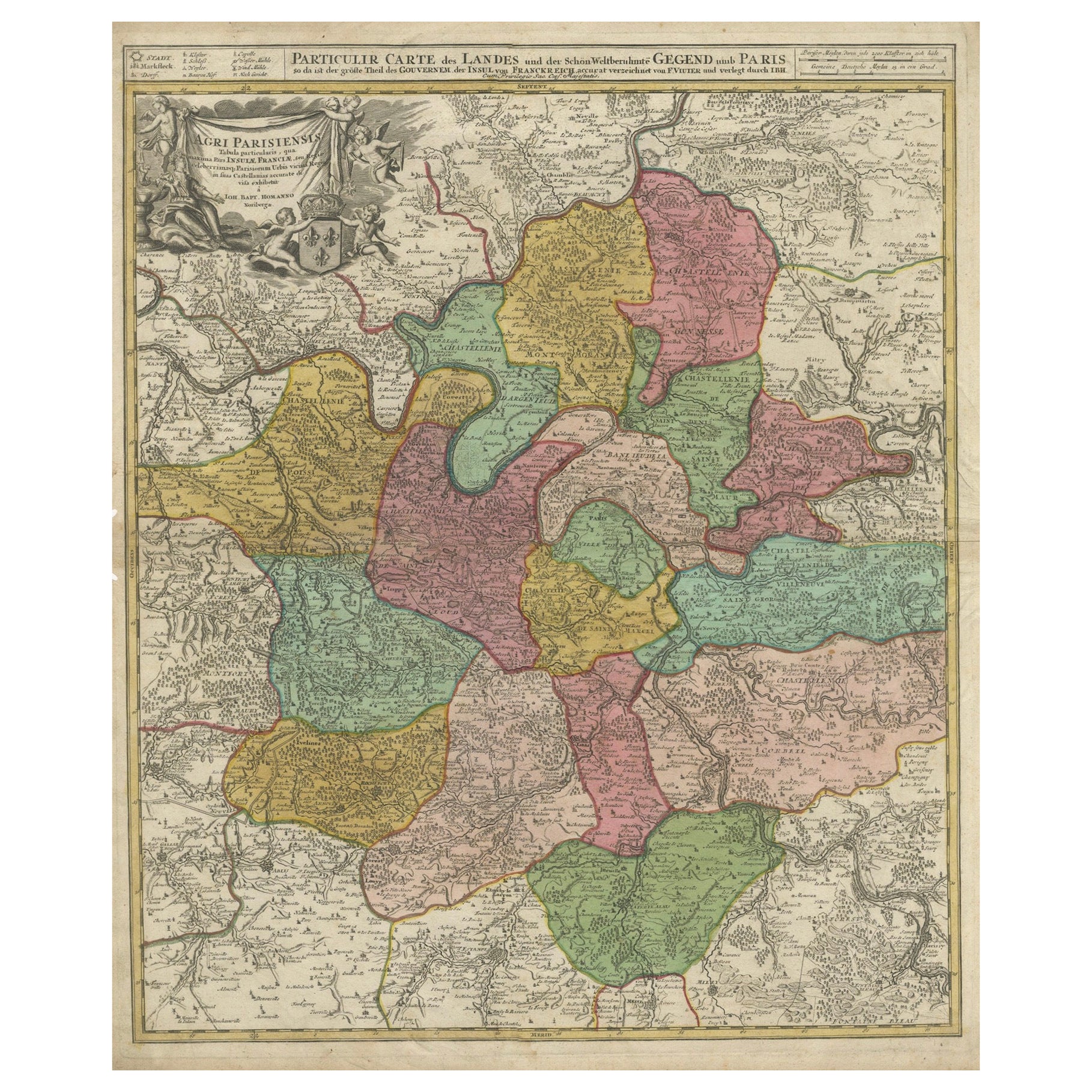
Antique map titled 'Agri Parisiensis Tabula particularis, qua maxima Pars Insulae Franciae (..)'. Incredibly detailed map showing everything from tiny villages to forests, farmland, walled cities and more. Centered on Paris, the map extends to show these cities at the extremities - Ablis, Messe, Herissy, Senlies, and Mante. Details in Paris includes its fortifications and the gardens at Vincennes. Beautiful cartouche with several putti.
- Dimensions:Height: 29.93 in (76 cm)Width: 26.19 in (66.5 cm)Depth: 0.02 in (0.5 mm)
- Materials and Techniques:
- Place of Origin:
- Period:
- Date of Manufacture:circa 1720
- Condition:Great condition, frame included. Please study image carefully.
- Seller Location:Langweer, NL
- Reference Number:Seller: BG-070691stDibs: LU3054310288183
About the Seller
5.0
Recognized Seller
These prestigious sellers are industry leaders and represent the highest echelon for item quality and design.
Platinum Seller
Premium sellers with a 4.7+ rating and 24-hour response times
Established in 2009
1stDibs seller since 2017
2,836 sales on 1stDibs
Typical response time: 1 hour
- ShippingRetrieving quote...Shipping from: Langweer, Netherlands
- Return Policy
More From This Seller
View AllAntique Map of the City of Paris by Tirion
1763
Located in Langweer, NL
Antique map titled 'Nieuwe Kaart der platte Grond van de Stad Parys (..)'. Beautiful city plan of Paris, France. This map originates from 'Nieuwe en Beknopte Hand-Atlas, bestaande in...
Category
Antique Mid-18th Century Maps
Materials
Paper

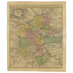
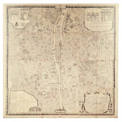
Antique Map of the Region of Paris by Homann Heirs, c.1720
By Homann Heirs
Located in Langweer, NL
Antique map titled 'Agri Parisiensis Tabula particularis, qua maxima Pars Insulae Franciae (..).' Incredibly detailed map showing everything from tiny villages to forests, farmland, ...
Category
Antique 18th Century Maps
Materials
Paper
Antique Map of the Lorraine
North-East France
by J. B. Homann, circa 1720
Located in Langweer, NL
Antique map of Lorraine in north-east France by J. B. Homann. Covering the area around Metz, Nancy and Sarrebruck with Luxembourg in the North and Mulhouse in Southeast. With a decor...
Category
Antique Early 18th Century Maps
Materials
Paper

Detailed 18th-Century Map of Paris and Its Surrounding Regions by Johann Homann
Located in Langweer, NL
This map, titled “Agri Parisiensis Tabula particularis,” was created and published by the German cartographer Johann Baptist Homann (1664–1724), or his workshop, in Nuremberg. Homann...
Category
Antique 1720s Maps
Materials
Paper
Antique Map of the Region of Île-de-France by Hondius, circa 1630
Located in Langweer, NL
Antique map titled Gouvernement de l'Isle de France'. Old map of the region of Île-de-France, France. It is located in the north-central part of the country and often called the régi...
Category
Antique Mid-17th Century Maps
Materials
Paper

Antique Map of France by Mortier
c.1710
Located in Langweer, NL
Antique map titled 'Gallia vetus ex C. Iulii Caesaris (..)'. Original antique map of France. Published by P. Mortier, c.1710.
Category
Antique Early 18th Century Maps
Materials
Paper

$949 Sale Price
20% Off
You May Also Like
Map Of The City Of Geneva, Framed Engraving, Late 18th Century
Located in MARSEILLE, FR
Beautiful engraving representing the city of Geneva corrected in 1775 and 1793
The engraving also presents inserts with the evolution of the city, the plan of ancient Geneva and ...
Category
Antique Late 18th Century Swiss Louis XV Prints
Materials
Paper

Antique Map of Paris, "Carte Routiere des Environs de Paris" 1841
Located in Colorado Springs, CO
This beautiful hand-colored road map of Paris was published in 1841. The map shows Paris and the surrounding area in a folding pocket map. Organized and detailed for travelers, this ...
Category
Antique 1840s French Maps
Materials
Paper

Antique Map of Bohemia, Dutch, Framed Cartography, Johannes Janssonius, C.1630
Located in Hele, Devon, GB
This is an antique map of Bohemia. A Dutch, framed atlas engraving of modern day Germany, Austria and the Czech Republic by Johannes Janssonius, dating to the 17th century and later,...
Category
Antique 17th Century Dutch Baroque Maps
Materials
Glass, Paper
L
Isle de France: A Hand-colored 17th Century Map by De Wit
By Frederick de Wit
Located in Alamo, CA
This colorful and detailed 17th century hand-colored copperplate map by Frederick De Wit was published in Amsterdam between 1666 and 1760. The map depicts the Île-de-France, which is one of the ancient provinces of France. Paris is located in the center of the map, with Versailles to the southwest The map extends from Rouen in the west to Reims in the east. The area around Paris, the Véxin Français, was the original domain of the king of France. Other areas were ruled by French feudal lords. For example, the Véxin Normand area was the domain of the Duke of Normandy...
Category
Early 18th Century Old Masters More Prints
Materials
Engraving

"Plan de Paris" - Antique Recreation of a Map of Paris
Located in New York, NY
Printed in the Early 20th Century, this antique "Plan de Paris" is a recreation of an earlier map from 1710, originally commissioned by Louis XIV. It was an intricately rendered view...
Category
Early 20th Century French Louis XIV Maps
Materials
Linen, Wood, Paper
17th Century Framed Map of Ancient France Titled "Typus Galliae Veteris"
Located in Dallas, TX
Decorate an office or a library with this elegant historic map. Crafted in the Netherlands circa 1630, this beautifully framed antique map with pr...
Category
Antique 17th Century Dutch Baroque Maps
Materials
Glass, Giltwood, Paper

More Ways To Browse
Antique Map Paris
Map Of Paris
Illustrated Map
Antique World Maps
Antique Southern Furniture
Map Of Europe
Antique Maps Of Holland
Compass Rose Antique
Antique Furniture Portugal
Antique Maps Of Europe
Mexican Antiques
Map Of Africa
Mississippi Antique
Antique Furniture Plans
Ancient Collectibles
Antique Wood Coat Of Arms
Antique Quadrant
Antique Maps Of Africa