Items Similar to Antique Map of France by Covens
Son, c.1790
Want more images or videos?
Request additional images or videos from the seller
1 of 5
Antique Map of France by Covens
Son, c.1790
$533.95
£398.62
€450
CA$741.82
A$797.93
CHF 426.44
MX$9,405.35
NOK 5,376.39
SEK 4,915.04
DKK 3,429.51
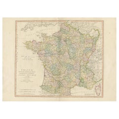
About the Item
A detailed description of the 'Carte de France divisée en 83 Departements (..)', an antique map circa 1790, along with information about its publishers, Covens
Mortier:
**Title**: 'Carte de France divisée en 83 Departements (..)'
**Date**: Circa 1790
**Description**: This large map of France, notable for its division into 83 departments, is a significant historical artifact from the late 18th century. It reflects the administrative changes in France that followed the French Revolution, which reorganized the country into departments from the previous provincial structure. The map is extended with text on both sides, providing additional context and detail about the regions depicted. This feature enhances its value as both a cartographic and educational resource.
**Artists and Engravers**: The map was produced by Covens
Mortier, a renowned Dutch publishing firm known for its extensive and successful history in map publishing. The firm was established by Pierre Mortier the Elder (1661-1711), who initially obtained the privilege to distribute the works of French geographers in the Netherlands. After Pierre's widow managed the business for several years, Cornelis Mortier took over in 1719. In 1721, Cornelis forged a partnership with Johannes Covens, who had married Cornelis’ sister, leading to the creation of the Covens
Mortier name. This partnership continued through various family successors, including Johannes Covens II and later Cornelis (son of Johannes Covens II), who integrated Petrus Mortier IV (the great-grandson of Petrus Mortier I) back into the business. In 1794, the company was renamed Mortier, Covens
Zoon, reflecting its enduring legacy and family lineage in the field of map publishing.
**Significance**: The map is a testament to the skill and artistry of Covens
Mortier, showcasing their ability to blend accurate geographic information with detailed and aesthetically pleasing design. As a historical document, it provides insights into the geographical understanding of France during a pivotal period in its history. The map's large format, detailed text, and division into departments make it a valuable resource for historians, collectors, and enthusiasts of cartography.
- Dimensions:Height: 22.64 in (57.5 cm)Width: 50.79 in (129 cm)Depth: 0 in (0.01 mm)
- Materials and Techniques:
- Period:
- Date of Manufacture:circa 1790
- Condition:Condition: Good, extended with text on both sides (joined). General age-related toning, creasing and minor wear. Blank verso, please study image carefully.
- Seller Location:Langweer, NL
- Reference Number:Seller: BG-12390-601stDibs: LU3054326191432
About the Seller
5.0
Recognized Seller
These prestigious sellers are industry leaders and represent the highest echelon for item quality and design.
Platinum Seller
Premium sellers with a 4.7+ rating and 24-hour response times
Established in 2009
1stDibs seller since 2017
2,836 sales on 1stDibs
Typical response time: 1 hour
- ShippingRetrieving quote...Shipping from: Langweer, Netherlands
- Return Policy
More From This Seller
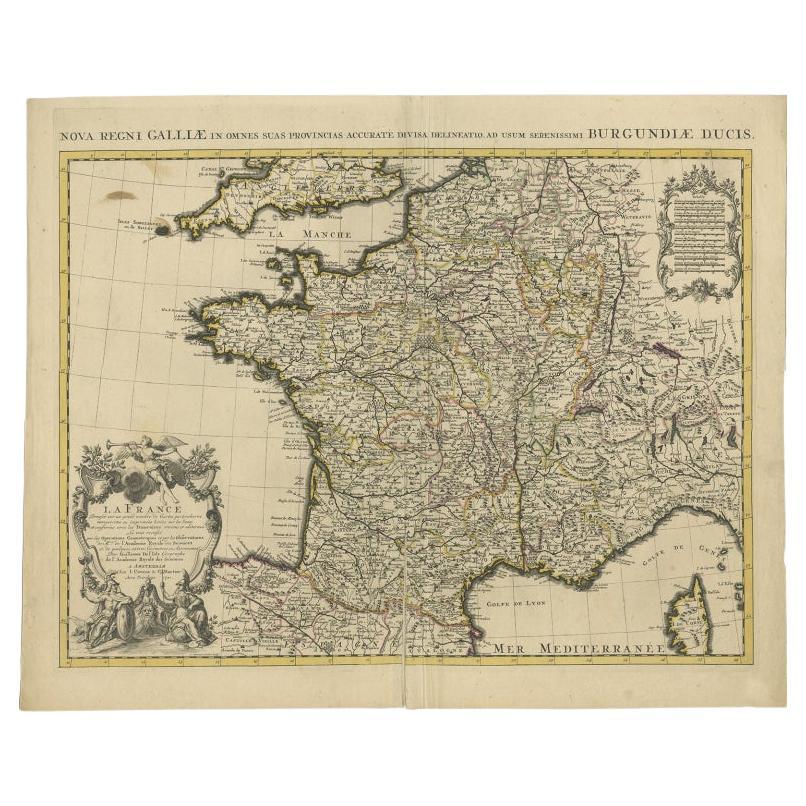
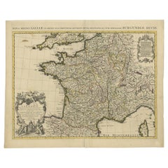
View AllAntique Map of France by Covens
Mortier, c.1730
Located in Langweer, NL
Antique map titled 'Nova regni Galliae (..) La France'. Old map of France with large decorative title cartouche. With great detail.
Artists and Engravers: Pieter und David Mortie...
Category
Antique 18th Century Maps
Materials
Paper
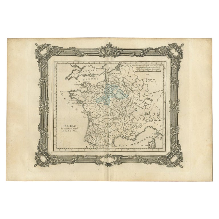
Antique Map of France under the Second Race by Zannoni, 1765
Located in Langweer, NL
Antique map France titled 'Tableau du Domaine Royal (..)'. Beautiful old map of France. This map originates from 'Atlas Historique de la France Ancienne et Moderne' by M. Rizzi Zanno...
Category
Antique 18th Century Maps
Materials
Paper
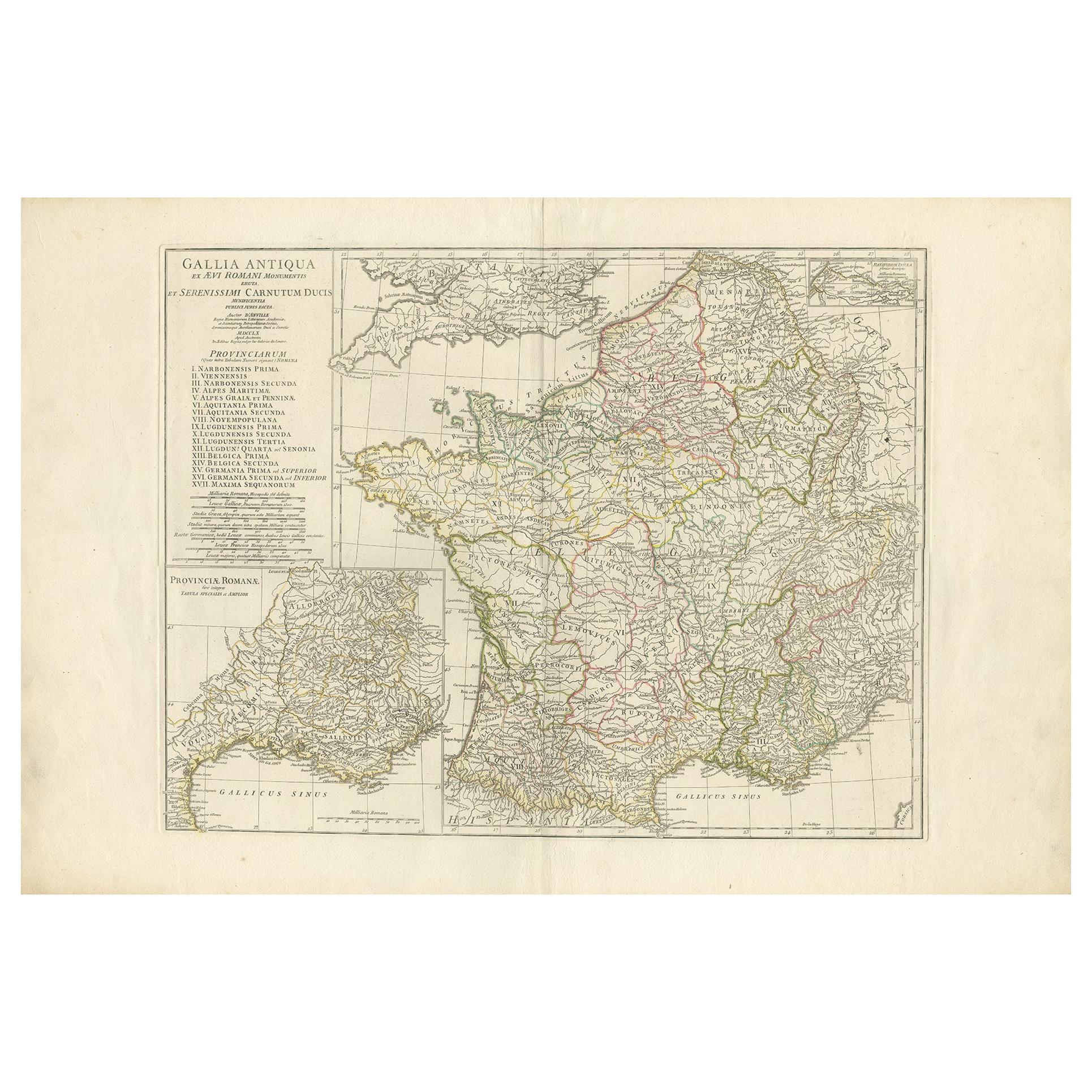
Antique Map of France in Ancient Roman Times by d
Anville, c.1795
Located in Langweer, NL
Antique map titled 'Gallia Antiqua ex Aevi Romani Monumentis (..)'. Original, large, map of France in ancient Roman times. Bottom left, a large inset shows Gallia's southern most Rom...
Category
Antique Late 18th Century French Maps
Materials
Paper

$664 Sale Price
30% Off
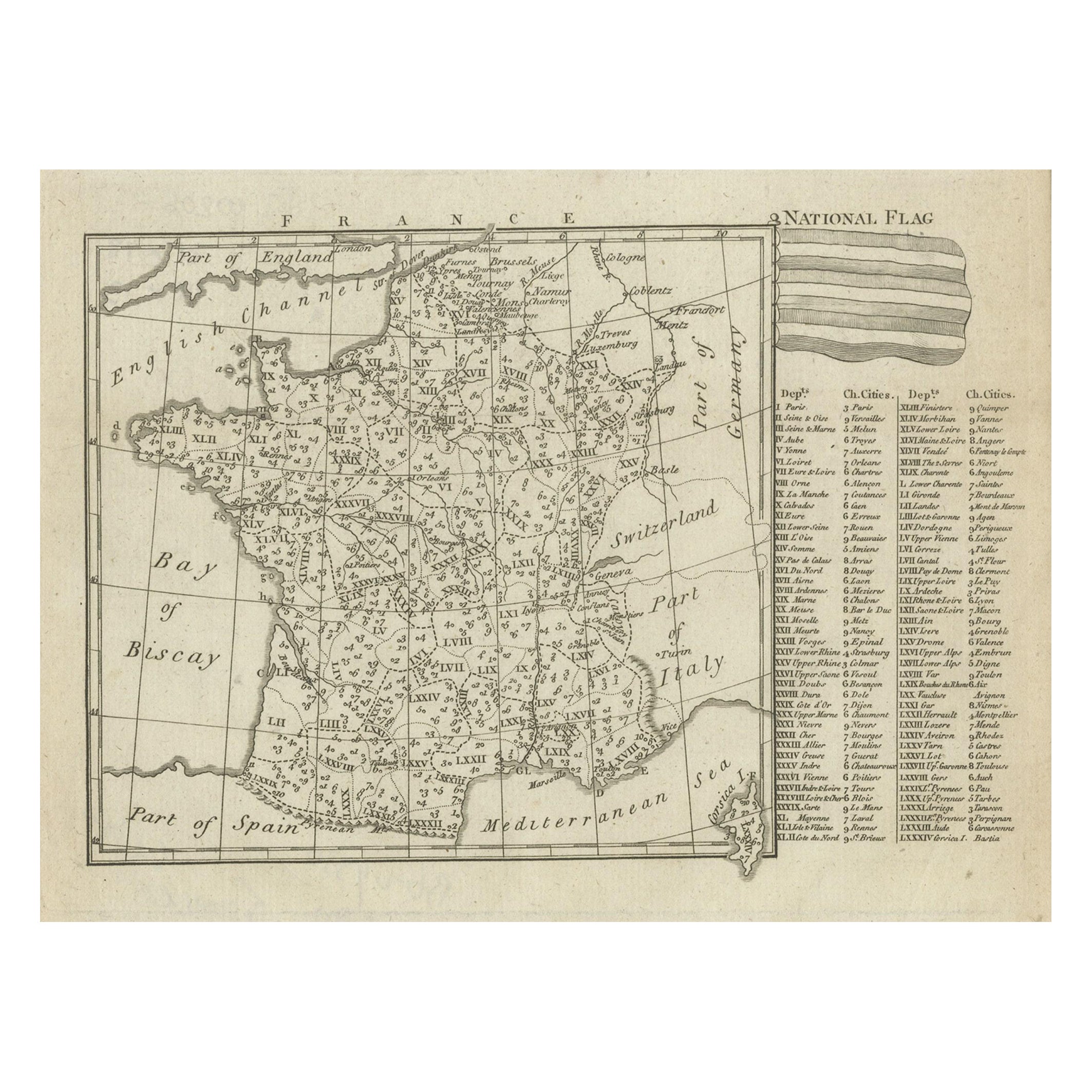
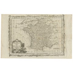
Small Detailed Antique Map of France, c.1780
Located in Langweer, NL
Antique map titled 'France'. Small, detailed map of France with legend. Also depicting the English Channel, Bay of Biscay, Part of Spain, the Mediterranean Sea, Part of Italy, Switze...
Category
Antique 18th Century Maps
Materials
Paper
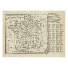
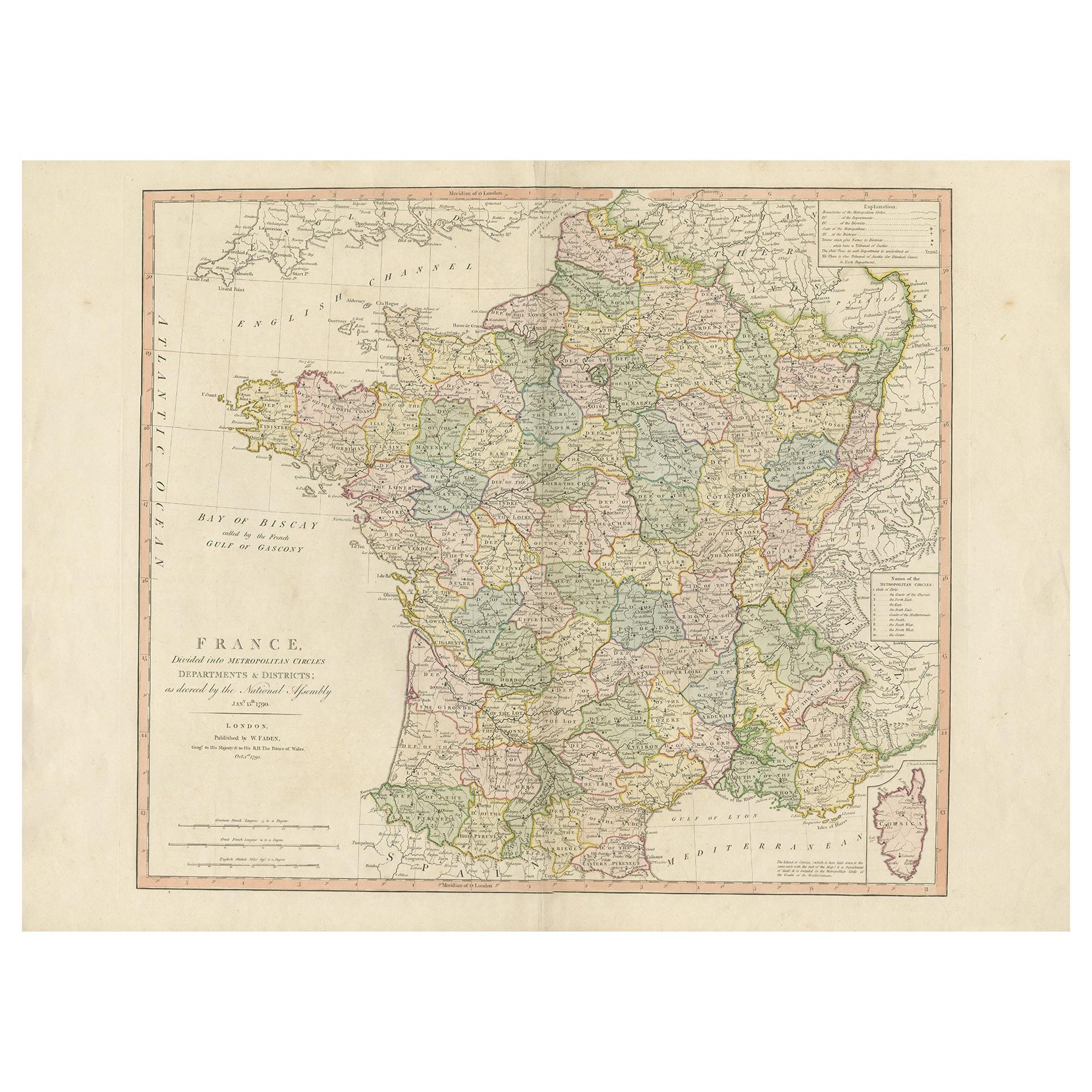
Antique Map of France by Faden
1792
Located in Langweer, NL
Antique map titled 'France divided into Metropolitan Circles (..)'. Large, original antique map of France, with a small inset of the island of Co...
Category
Antique Late 18th Century Maps
Materials
Paper
$617 Sale Price
20% Off
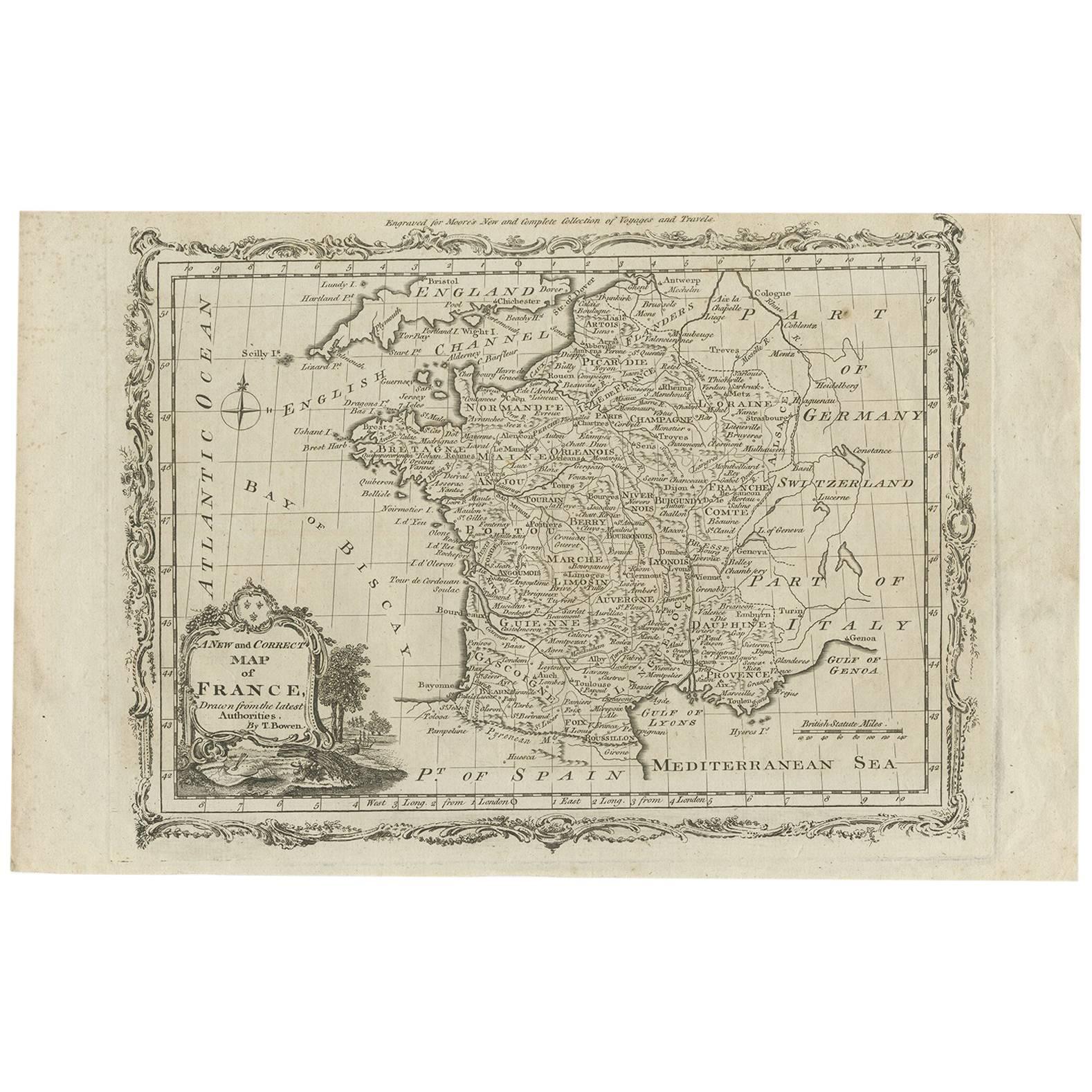
Antique Map of France by T. Bowen, Paper Engraving, Late 18th Century
Located in Langweer, NL
Decorative antique map of France titled 'A new and accurate map of France, Drawn from the latest Authorities by T. Bowen'. Engraved for Moore’s new and complete collection of Voyages...
Category
Antique Late 18th Century British Maps
Materials
Paper
You May Also Like
Large 19th Century Map of France
Located in Pease pottage, West Sussex
Large 19th Century Map of France.
Remarkable condition, with a pleasing age worn patina.
Recently framed.
France Circa 1874.
Category
Antique Late 19th Century French Maps
Materials
Linen, Paper

Original Large Antique Map of Paris, France by John Dower, 1861
Located in St Annes, Lancashire
Fabulous monochrome map of Paris.
Vignettes of St Germain En Laye, Saint Cloud, Versailles and Fontainbleau.
Unframed.
Drawn by J.Dower.
Lithography by Weller. 4 sheets joined to...
Category
Antique 1860s English Victorian Maps
Materials
Paper

1771 Bonne Map of Poitou, Touraine and Anjou, France, Ric.a015
Located in Norton, MA
1771 Bonne Map of Poitou,
Touraine and Anjou, France
Ric.a015
1771 Bonne map of Potiou, Touraine and Anjou entitled "Carte des Gouvernements D'Anjou et du Saumurois, de la Touraine, du Poitou,du Pays d'aunis, Saintonge?Angoumois,"
Carte des gouvernements d'Anjou et du Saumurois, de la Touraine, du Poitou, du Pays d'Aunis, Saintonge-Angoumois. Projettee et assujettie au ciel par M. Bonne, Hyd. du Roi. A Paris, Chez Lattre, rue St. Jacques a la Ville de Bord(ea)ux. Avec priv. du Roi. 1771. Arrivet inv. & sculp., Atlas moderne ou collection de cartes sur toutes...
Category
Antique 17th Century Unknown Maps
Materials
Paper

Antique Map of France
Located in Dallas, TX
Nice antique map of France in wood frame. This would make a great gift for a collector. A wonderful accessory!
Category
Early 20th Century Decorative Art
Materials
Glass, Wood, Paper

$1,760
The Normandy Region of France: A 17th C. Hand-colored Map by Sanson and Jaillot
By Nicolas Sanson
Located in Alamo, CA
This large hand-colored map entitled "Le Duché et Gouvernement de Normandie divisée en Haute et Basse Normandie en divers Pays; et par evêchez, avec le Gouvernement General du Havre ...
Category
Antique 1690s French Maps
Materials
Paper

Map of France - Etching - 1820
Located in Roma, IT
Map of France is an Original Etching realized by an unknown artist of 19th century in 1820.
Very good condition on two sheets of white paper joined at t...
Category
1820s Modern Figurative Prints
Materials
Etching

More Ways To Browse
Antique Nautical Maps
Sri Lanka Map
Hand Painted Antique Map
Ottoman Map
Philippines Map
Roman Empire Map
Sebastian Munster
South African Antique
Antique Sri Lanka Map
Maps Balkans
Antique Map Of Jerusalem
Map Of Corsica
Solomons Temple
Antique Map Of Korea
Map Of Jerusalem
Prussia Map
Antique Maps Caribbean Islands
Antique Wine Maps