Items Similar to Antique Map of France by T. Kitchin, Engraved, Circa 1779


Want more images or videos?
Request additional images or videos from the seller
1 of 10
Antique Map of France by T. Kitchin, Engraved, Circa 1779
$516.46
£382.91
€430
CA$709.49
A$774.53
CHF 407.80
MX$9,277.95
NOK 5,215.60
SEK 4,761.93
DKK 3,276.44
About the Item
Antique map titled 'The Kingdom of France (..)'. Large antique map of the Kingdom of France. Engraved by T. Kitchin. Published J. Blair, circa 1779.
- Dimensions:Height: 18.43 in (46.8 cm)Width: 24.49 in (62.2 cm)Depth: 0.02 in (0.5 mm)
- Materials and Techniques:Paper,Engraved
- Place of Origin:
- Period:
- Date of Manufacture:c.1779
- Condition:General age-related toning. Original folding lines, with small splits. Some wear and soiling. Blank verso. Please study image carefully.
- Seller Location:Langweer, NL
- Reference Number:Seller: BG-13417-51stDibs: LU3054333999092
About the Seller
5.0
Recognized Seller
These prestigious sellers are industry leaders and represent the highest echelon for item quality and design.
Platinum Seller
Premium sellers with a 4.7+ rating and 24-hour response times
Established in 2009
1stDibs seller since 2017
2,810 sales on 1stDibs
Typical response time: <1 hour
- ShippingRetrieving quote...Shipping from: Langweer, Netherlands
- Return Policy
More From This Seller
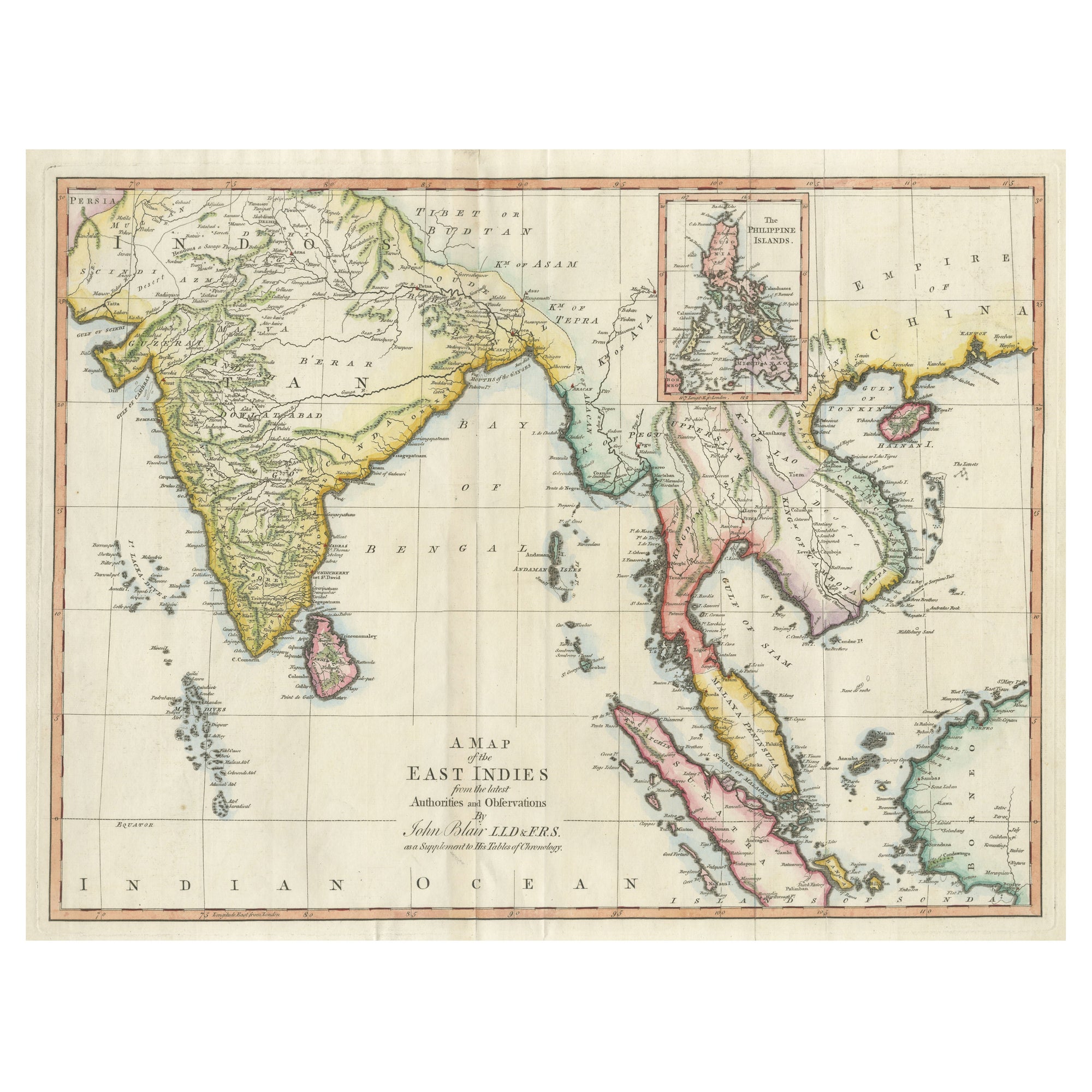
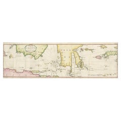
View AllAntique Map of the East Indies by T. Kitchin, Engraved, Circa 1779
Located in Langweer, NL
Antique map titled 'A Map of the East Indies (..)'. Large antique map of Southeast Asia, India, and part of China, extending to Tibet, the Maladives, Sumatra, part of Borneo, Hainan,...
Category
Antique Late 18th Century British Maps
Materials
Paper

$470 Sale Price
20% Off
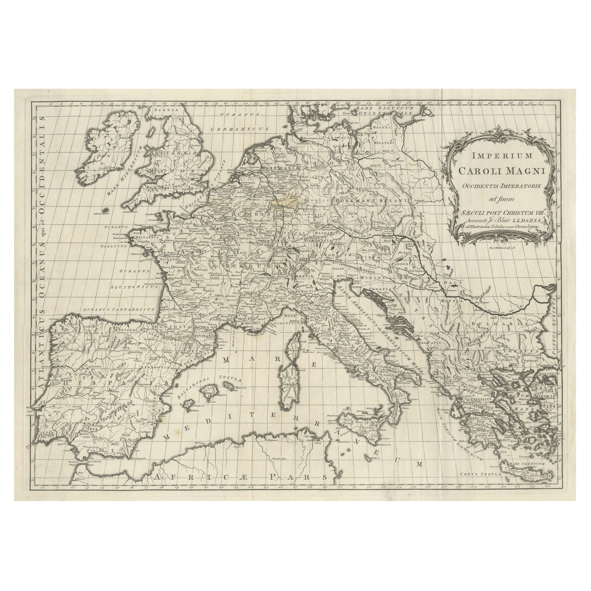
Antique Map of Europe by T. Kitchin, Charlemagne
s Empire, Circa 1779
Located in Langweer, NL
Antique map titled 'Imperium Caroli Magni (..)'. Large antique map of Europe, showing the Empire of Charlemagne in the 8th Century. Engraved by T. Kitchin. Published J. Blair, circa ...
Category
Antique Late 18th Century British Maps
Materials
Paper
$441 Sale Price
20% Off
Antique Map of Germany by T. Kitchin, circa 1770
Located in Langweer, NL
Antique map titled 'An Accurate Map of Germany (..) '. Drawn from the best Authorities by T.Kitchin Geogr." Rare edition, drawn and etched by Thomas Kitchin, published, circa 1770.
Category
Antique Mid-18th Century Maps
Materials
Paper

Antique Map of Russia in Europe by T. Kitchin, circa 1770
Located in Langweer, NL
Antique map titled 'Russia or Moscovy in Europe, drawn from the latest authorities (..)'. An interesting and attractive early 19th century map of Russia in Europe which was engraved ...
Category
Antique Late 18th Century Maps
Materials
Paper

Rare Authentic Engraved Map of Large Part of Indonesia by Stavorinus, 1779
Located in Langweer, NL
Antique map titled 'Carte de la Navigation de Batavia a Amboina'. Rare chart of Indonesia including Borneo, Java, Celebes, Ceram and more. This map originates from 'Voyage par le Cap...
Category
Antique 18th Century Maps
Materials
Paper
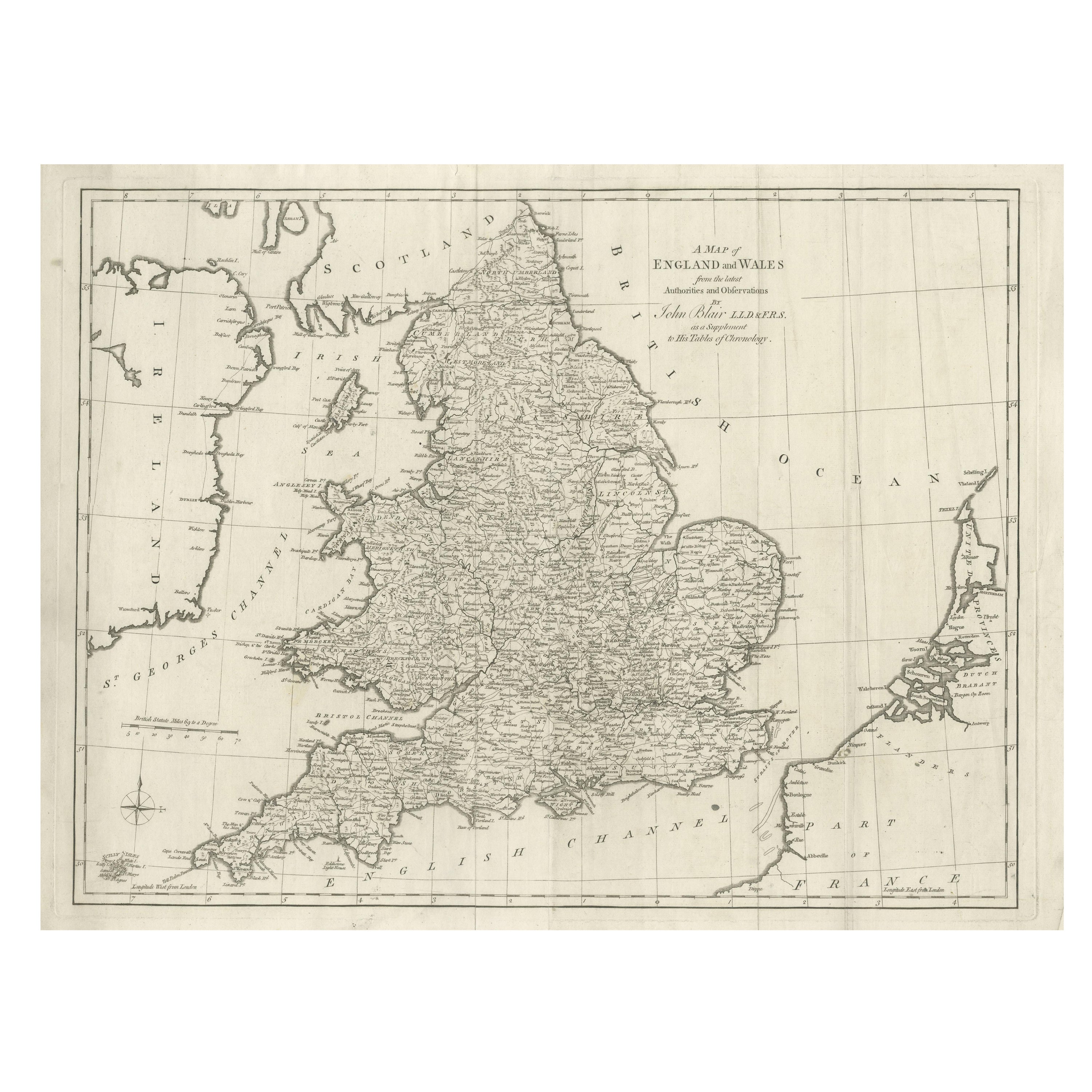
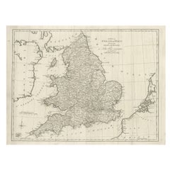
Antique Map of England and Wales by J. Blair, Circa 1779, Wall Art
Located in Langweer, NL
Antique map titled 'A Map of England and Wales (..)'. Large antique map of England and Wales, with part of the continental and Irish coasts. Published J. Blair, circa 1779.
Category
Antique Late 18th Century British Maps
Materials
Paper
You May Also Like
Original Antique Map of Sweden, Engraved by Barlow, 1806
Located in St Annes, Lancashire
Great map of Sweden
Copper-plate engraving by Barlow
Published by Brightly & Kinnersly, Bungay, Suffolk. 1806
Unframed.
Category
Antique Early 1800s English Maps
Materials
Paper

Antique Map of Principality of Monaco
By Antonio Vallardi Editore
Located in Alessandria, Piemonte
ST/619 - "Old Geographical Atlas of Italy - Topographic map of ex-Principality of Monaco" -
ediz Vallardi - Milano -
A somewhat special edition ---
Category
Antique Late 19th Century Italian Other Prints
Materials
Paper

Original Antique Map of The World by Thomas Clerk, 1817
Located in St Annes, Lancashire
Great map of The Eastern and Western Hemispheres
On 2 sheets
Copper-plate engraving
Drawn and engraved by Thomas Clerk, Edinburgh.
Published by Mackenzie And Dent, 1817
...
Category
Antique 1810s English Maps
Materials
Paper

Original Antique Map of Europe, Arrowsmith, 1820
Located in St Annes, Lancashire
Great map of Europe
Drawn under the direction of Arrowsmith.
Copper-plate engraving.
Published by Longman, Hurst, Rees, Orme and Brown, 1820
...
Category
Antique 1820s English Maps
Materials
Paper

Original Antique Map of Hungary, Arrowsmith, 1820
Located in St Annes, Lancashire
Great map of Hungary
Drawn under the direction of Arrowsmith.
Copper-plate engraving.
Published by Longman, Hurst, Rees, Orme and Brown, 1820
Unframed.
Category
Antique 1820s English Maps
Materials
Paper

Original Antique Map of Ireland- Kerry. C.1840
Located in St Annes, Lancashire
Great map of Kerry
Steel engraving
Drawn under the direction of A.Adlard
Published by How and Parsons, C.1840
Unframed.
Category
Antique 1840s English Maps
Materials
Paper

More Ways To Browse
Georgetown Map
Hemisphere Antiques
J Matthews
Japanese Kite
Maltese Falcon
Map Tuscany
St Eustatius
Sumba Map
Used Furniture Denver Co
Used Furniture Leominster
Vintage Long Island Map
Vintage World Map Desk
Vintage World Map Mirror
Antique Furniture Toledo Ohio
Antique Maps Washington Dc
Blaeu World Map
Cape Cod Map
F Colton