Items Similar to Antique Map of Frisian Municipality of Achtkarspelen in the Netherlands, 1868


Want more images or videos?
Request additional images or videos from the seller
1 of 5
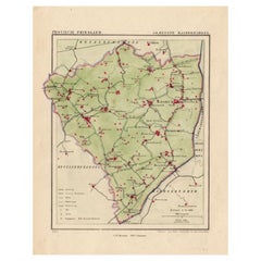
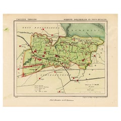
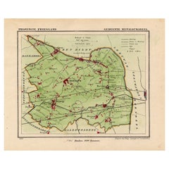
Antique Map of Frisian Municipality of Achtkarspelen in the Netherlands, 1868
$134.61
$168.2720% Off
£99.71
£124.6420% Off
€112
€14020% Off
CA$184.15
CA$230.1820% Off
A$200.71
A$250.8920% Off
CHF 106.11
CHF 132.6420% Off
MX$2,416.16
MX$3,020.2020% Off
NOK 1,346.84
NOK 1,683.5520% Off
SEK 1,234.78
SEK 1,543.4720% Off
DKK 853.38
DKK 1,066.7220% Off
About the Item
Antique map titled 'Provincie Friesland - Gemeente Achtkarspelen'. Map of the township of Achtkarspelen including Buitenpost, Surhuisterveen and many other villages. This map originates from 'Gemeente-Atlas van Nederland' by J. Kuyper.
Artists and Engravers: Published by H. Suringar.
Condition: Fine; occasional foxing as visible on the scans; sheet irregularly cut, not affecting image. Please study image carefully.
Date: 1868
Overall size: 25 x 19 cm.
Image size: 19.5 x 16.5 cm.
- Dimensions:Height: 7.49 in (19 cm)Width: 9.85 in (25 cm)Depth: 0 in (0.01 mm)
- Materials and Techniques:
- Period:
- Date of Manufacture:1868
- Condition:
- Seller Location:Langweer, NL
- Reference Number:Seller: PCT-158691stDibs: LU3054325991822
About the Seller
5.0
Recognized Seller
These prestigious sellers are industry leaders and represent the highest echelon for item quality and design.
Platinum Seller
Premium sellers with a 4.7+ rating and 24-hour response times
Established in 2009
1stDibs seller since 2017
2,813 sales on 1stDibs
Typical response time: 1 hour
- ShippingRetrieving quote...Shipping from: Langweer, Netherlands
- Return Policy
More From This Seller
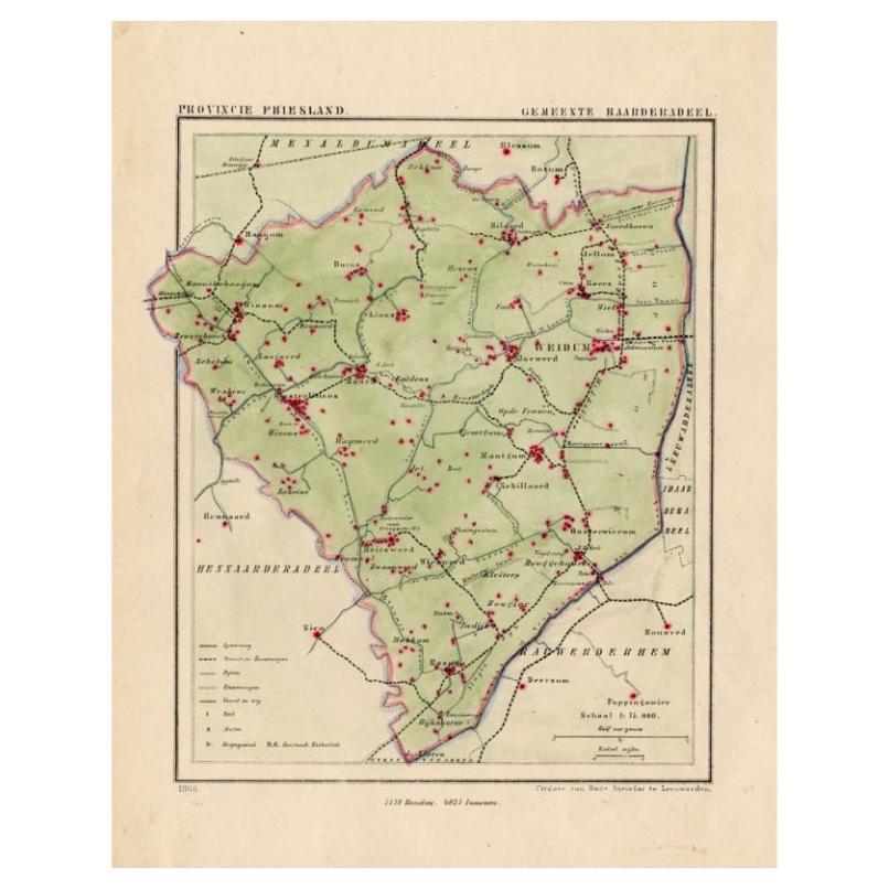
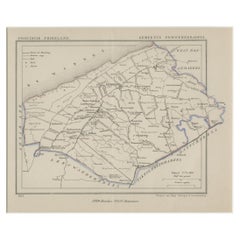
View AllAntique Map of Frisian Township of Baarderadeel in the Netherlands, 1868
Located in Langweer, NL
Antique map titled 'Provincie Friesland - Gemeente Baarderadeel'. Map of the township Baarderadeel including Weidum, Oosterlittens and many other villages. This map originates from '...
Category
Antique 19th Century Maps
Materials
Paper
Antique Map of Kollumerland, a Township in Friesland, The Netherlands, 1868
Located in Langweer, NL
Antique map titled 'Provincie Friesland - Gemeente Kollumerland en Nieuw-Kruisland'.
Map of the township of Kollumerland including Kollum, Westergeest, Burum and many other villa...
Category
Antique 19th Century Maps
Materials
Paper
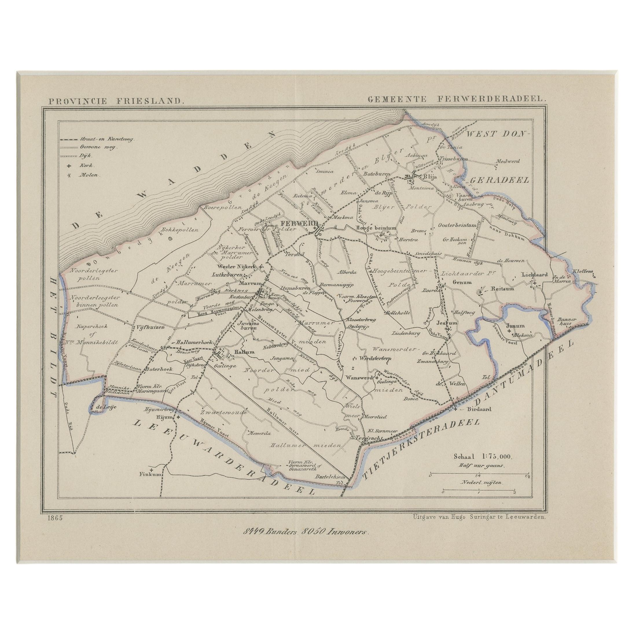
Antique Map of Ferwerderadeel, a County in Friesland, The Netherlands, 1868
Located in Langweer, NL
Antique map titled 'Provincie Friesland - Gemeente Ferwerderadeel'. Map of the township of Ferwerderadeel including Ferwerd, Blija and many other villages. This map originates from '...
Category
Antique 19th Century Maps
Materials
Paper
Antique Map of the Township of Anloo in the Netherlands, 1865
Located in Langweer, NL
Drenthe - Gemeente Anloo, Eext, Gasteren, Annen, Schipborg. These scarse detailed maps of Dutch Towns originate from the 'Gemeente-atlas' of Jacob Kuyper. This atlas of all towns in ...
Category
Antique 19th Century Maps
Materials
Paper
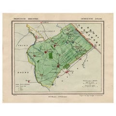
$134 Sale Price
20% Off
Antique Map of the Township of Roden, Drenthe, in the Netherlands, 1865
Located in Langweer, NL
Drenthe: Gemeente Roden, Roderwolde, Lieveren, Steenbergen, Ter Heijl. These scarse detailed maps of Dutch Towns originate from the 'Gemeente-atlas' of Jacob Kuyper. This atlas of al...
Category
Antique 19th Century Maps
Materials
Paper
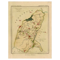
$182 Sale Price
20% Off
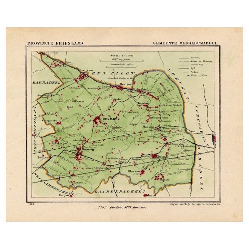
Antique Map of Menaldumadeel, Township in Friesland, The Netherlands, 1868
Located in Langweer, NL
Antique map titled 'Provincie Friesland - Gemeente Menaldumadeel'.
Map of the township of Menaldumadeel including Menaldum, Deinum, Boxum and many other villages. This map originat...
Category
Antique 19th Century Maps
Materials
Paper
You May Also Like
Original Antique English County Map, Cambridgeshire, J
C Walker, 1851
Located in St Annes, Lancashire
Great map of Cambridgeshire
Original colour
By J & C Walker
Published by Longman, Rees, Orme, Brown & Co. 1851
Unframed.
Category
Antique 1850s English Other Maps
Materials
Paper

Original Antique English County Map, Huntingdonshire, J
C Walker, 1851
Located in St Annes, Lancashire
Great map of Huntingdonshire
Original colour
By J & C Walker
Published by Longman, Rees, Orme, Brown & Co. 1851
Unframed.
Category
Antique 1850s English Other Maps
Materials
Paper

Original Antique English County Map, Nottinghamshire, J
C Walker, 1851
Located in St Annes, Lancashire
Great map of Nottinghamshire
Original colour
By J & C Walker
Published by Longman, Rees, Orme, Brown & Co. 1851
Unframed.
Category
Antique 1850s English Other Maps
Materials
Paper

Original Antique English County Map, Buckinghamshire, J
C Walker, 1851
Located in St Annes, Lancashire
Great map of Buckinghamshire
Original colour
By J & C Walker
Published by Longman, Rees, Orme, Brown & Co. 1851
Unframed.
Category
Antique 1850s English Other Maps
Materials
Paper

Original Antique English County Map, Warwickshire, J
C Walker, 1851
Located in St Annes, Lancashire
Great map of Warwickshire
Original colour
By J & C Walker
Published by Longman, Rees, Orme, Brown & Co. 1851
Unframed.
Category
Antique 1850s English Other Maps
Materials
Paper

Original Antique English County Map, Leicestershire, J
C Walker, 1851
Located in St Annes, Lancashire
Great map of Leicestershire
Original colour
By J & C Walker
Published by Longman, Rees, Orme, Brown & Co. 1851
Unframed.
Category
Antique 1850s English Other Maps
Materials
Paper

More Ways To Browse
1868 Furniture
Antique Texas Furniture
Military Map
Antique Maps New Zealand
Birds Eye View Map
North Africa Map
West Africa Map
Antique Compass Map
Antique Maps California
Biblical Maps
Hungary Map
Maps Of Mediterranean
Treasure Map
Antique Navigational Tools
Mississippi Furniture
Caribbean Antiques
Antique Maps West Indies
Antique Mozambique