Items Similar to Antique Map of Germany
Railways – Transport Network Overview, 1857
Video Loading
Want more images or videos?
Request additional images or videos from the seller
1 of 12
Antique Map of Germany
Railways – Transport Network Overview, 1857
$406.86
£303.88
€340
CA$560.52
A$610.87
CHF 323.48
MX$7,337.19
NOK 4,095.36
SEK 3,765.28
DKK 2,590.21
About the Item
Antique Map of Germany
Railways – Transport Network Overview, 1857
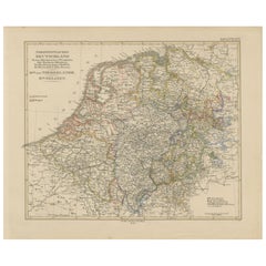
Striking 19th-century map titled "Deutschland und angränzende Länder zur Übersicht der Eisenbahnen und Hauptstrassen" (Germany and Neighboring Countries – Overview of Railways and Main Roads), published by Justus Perthes in Gotha in 1857. This transport-focused map offers a detailed look at the developing infrastructure of mid-19th-century Central Europe, with particular emphasis on Germany's expanding railway network.
Rather than focusing on political boundaries, this map prioritizes rail lines and major roads, which are clearly marked in red throughout the German Confederation and neighboring countries such as the Netherlands, Belgium, France, Switzerland, Austria, and parts of Poland. City names are prominently labeled, with regional capitals, major junctions, and hubs clearly indicated, providing insight into the logistics and travel patterns of the time.
The extensive railway lines reflect the rapid industrialization of the German states during the 1850s, connecting urban centers like Berlin, Frankfurt, Munich, Cologne, and Hamburg. Important trade routes to ports and industrial zones are visibly mapped, and the dense network reveals how transportation was transforming mobility, commerce, and communication across Europe.
A legend in the lower left corner explains the cartographic symbols for railroads, post routes, and boundaries, and the clarity of the engraving allows for easy interpretation of travel corridors.
This map is not only a historical document of cartography and transport history but also a compelling visual representation of Europe on the verge of unification and industrial expansion. It would greatly appeal to collectors interested in railway history, German unification, and antique transport maps.
Condition report:
Very good condition. Minor toning and faint spots near the outer margin. Engraving is crisp, and the red hand-coloring is clear. No tears, repairs, or annotations. Please inspect the image for finer details.
Framing tips:
For a scholarly or industrial aesthetic, use a black or dark metal frame with a clean off-white or light grey mat. A thin red inner mat line can enhance the visual impact of the highlighted railway routes. This piece suits office spaces, libraries, and transportation-themed collections.
Technique: Copperplate engraving with original hand-coloring
Maker: Justus Perthes, Gotha, 1857
- Dimensions:Height: 14.77 in (37.5 cm)Width: 17.88 in (45.4 cm)Depth: 0.01 in (0.2 mm)
- Materials and Techniques:Paper,Engraved
- Place of Origin:
- Period:
- Date of Manufacture:1857
- Condition:Very good condition. Minor toning and faint spots near the outer margin. Engraving is crisp, and the red hand-coloring is clear. No tears, repairs, or annotations. Please inspect the image for finer details.
- Seller Location:Langweer, NL
- Reference Number:Seller: BG-05552-271stDibs: LU3054346117522
About the Seller
5.0
Recognized Seller
These prestigious sellers are industry leaders and represent the highest echelon for item quality and design.
Platinum Seller
Premium sellers with a 4.7+ rating and 24-hour response times
Established in 2009
1stDibs seller since 2017
2,788 sales on 1stDibs
Typical response time: <1 hour
- ShippingRetrieving quote...Shipping from: Langweer, Netherlands
- Return Policy
More From This Seller
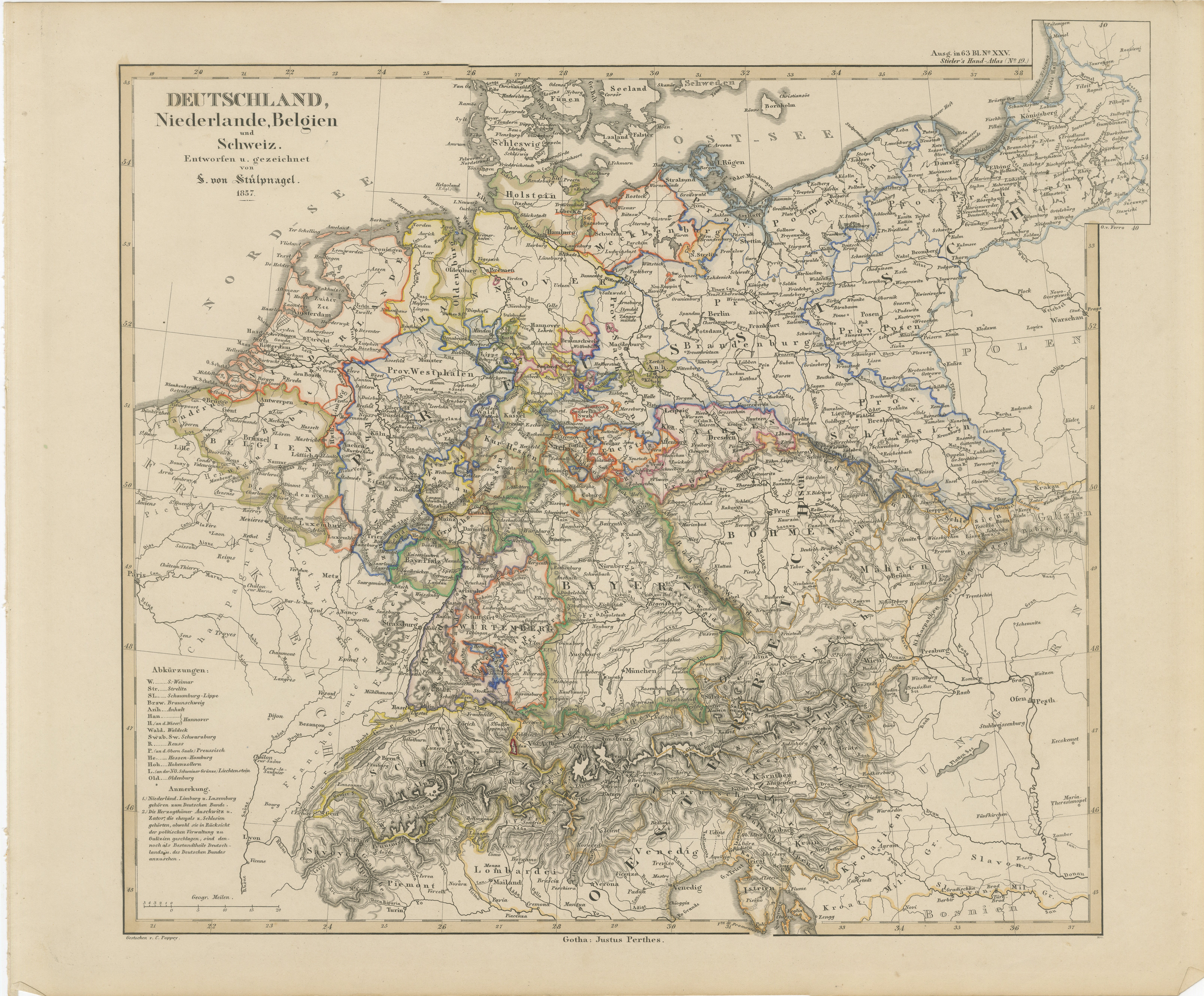
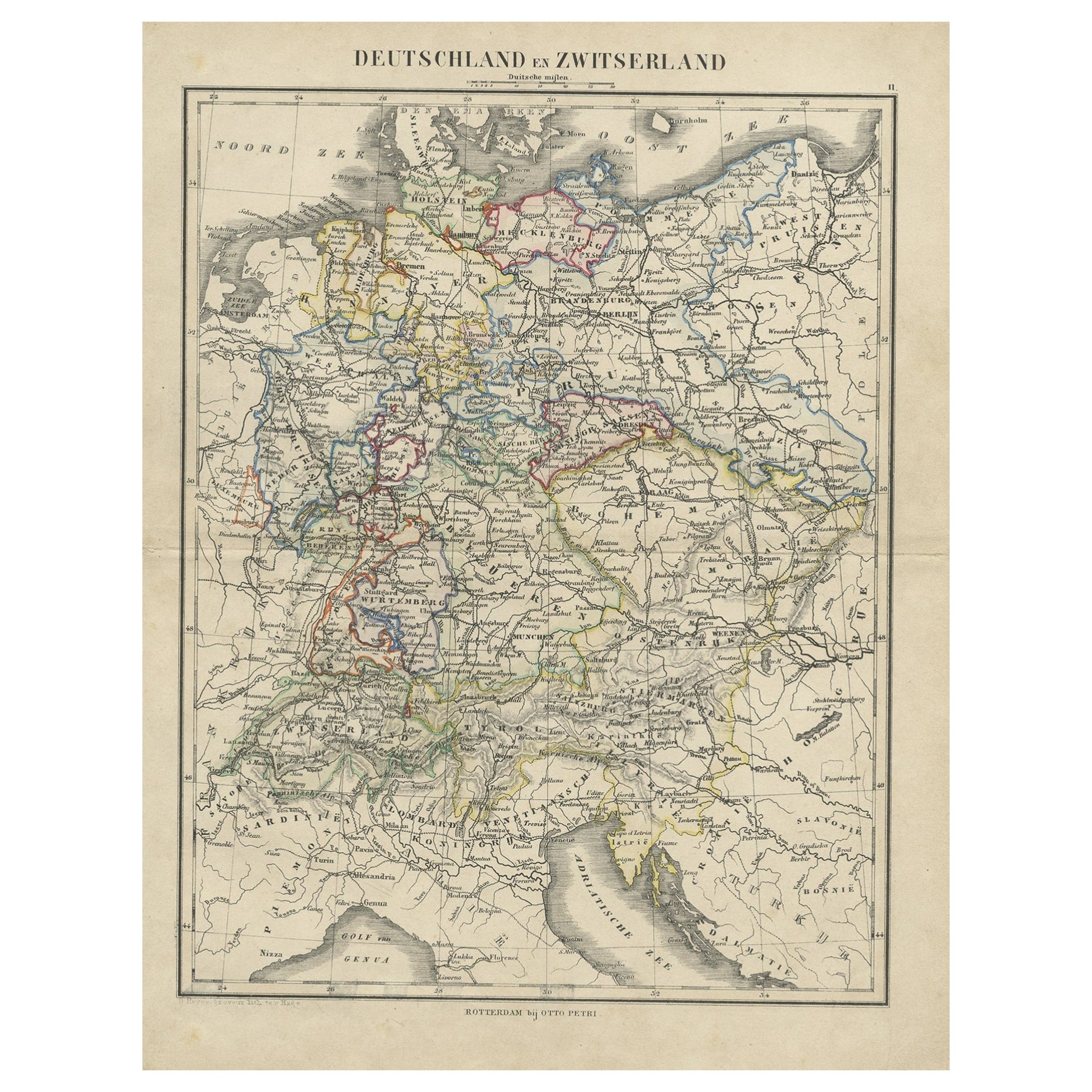
View AllAntique Map of Germany, Netherlands, Belgium
Switzerland – Stülpnagel, 1857
Located in Langweer, NL
Antique Map of Germany, Netherlands, Belgium & Switzerland – Stülpnagel, 1857
Fine mid-19th century map of Central Europe titled "Deutschland, Niederlande, Belgien, Schweiz", drawn ...
Category
Antique Mid-19th Century German Maps
Materials
Paper

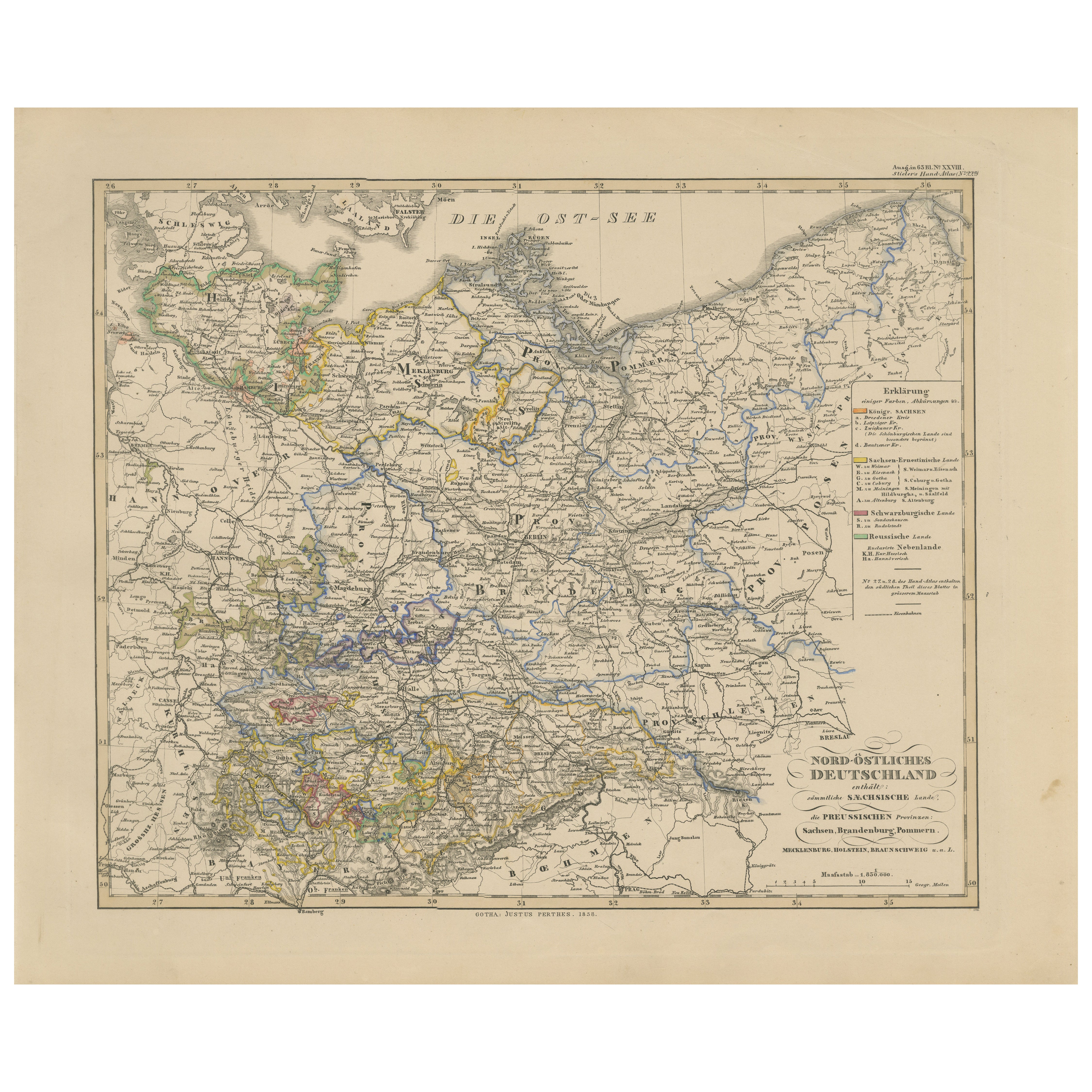
Antique Map of Northeastern Germany – Saxon
Prussian States, 1858
Located in Langweer, NL
Antique Map of Northeastern Germany – Saxon & Prussian States, 1858
Detailed and finely engraved map titled "Nord-Östliches Deutschland enthaltend die Sächsischen Länder und die Pre...
Category
Antique Mid-19th Century German Maps
Materials
Paper
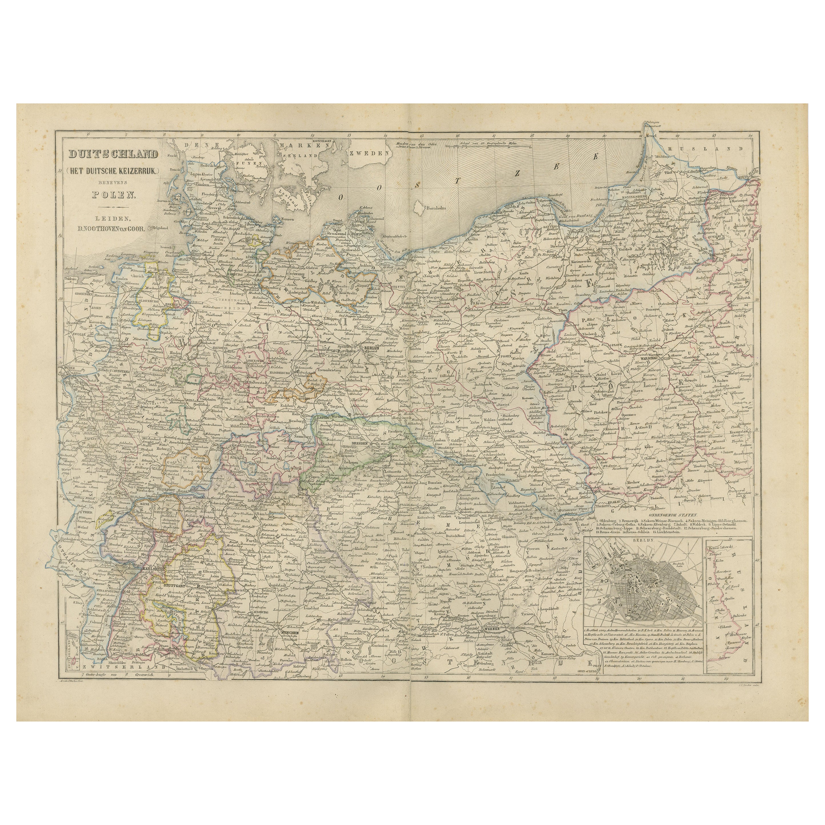
Germany Map with Berlin Inset – Het Duitsche Keizerrijk, Nieuwe Hand-Atlas 1876
Located in Langweer, NL
Germany Map with Berlin Inset – Het Duitsche Keizerrijk, Nieuwe Hand-Atlas 1876
This detailed 19th-century map of Germany, titled “Deutschland (Het Duitsche Keizerrijk),” was publis...
Category
Antique 1870s Dutch Maps
Materials
Paper
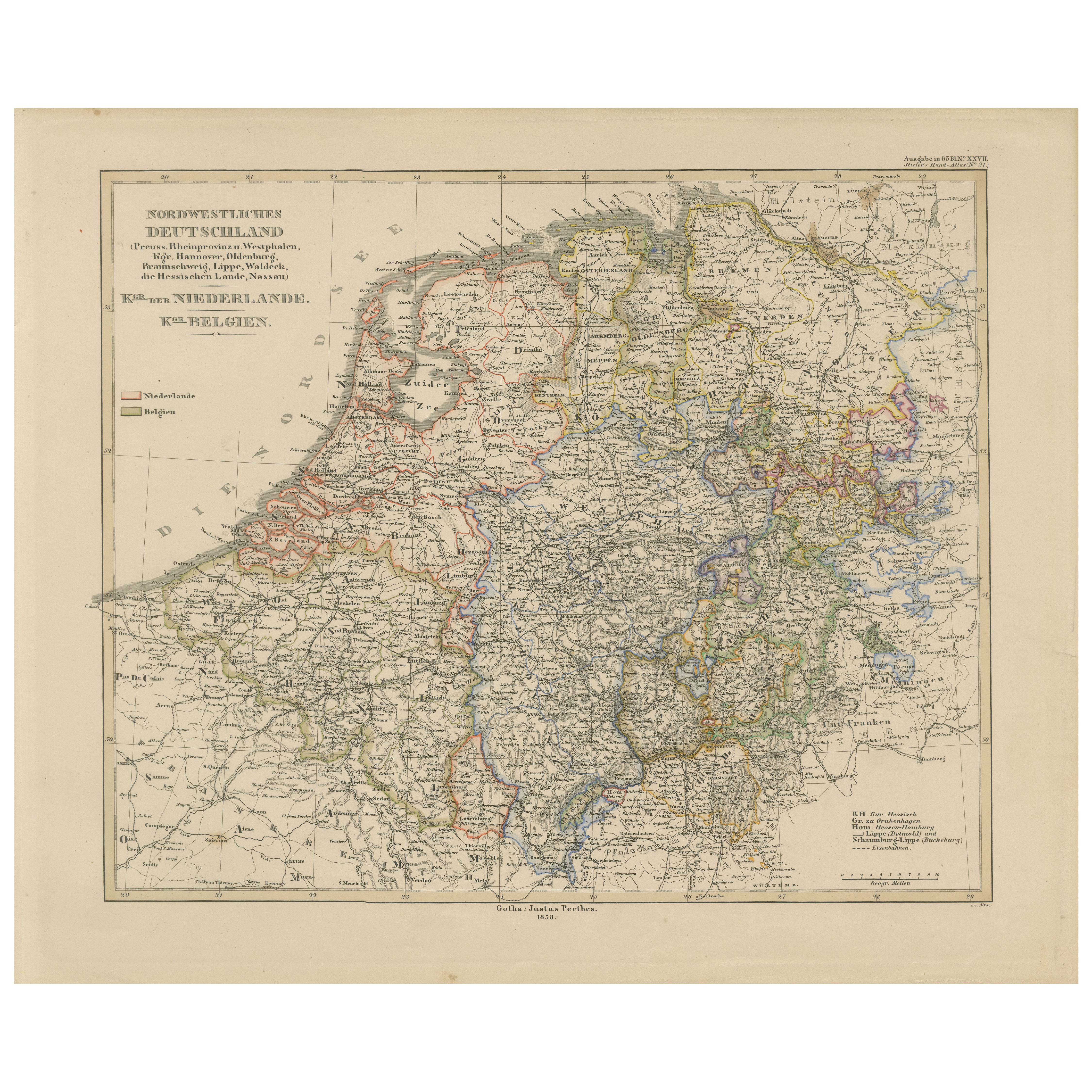
Antique Map of Prussia, Hanover, Netherlands
Belgium – 1858
Located in Langweer, NL
Antique Map of Northwestern Germany, Netherlands & Belgium – 1858
Detailed 19th-century engraved map titled "Nordwestliches Deutschland, Kgr. der Niederlande, Kgr. Belgien" (Northwe...
Category
Antique Mid-19th Century German Maps
Materials
Paper
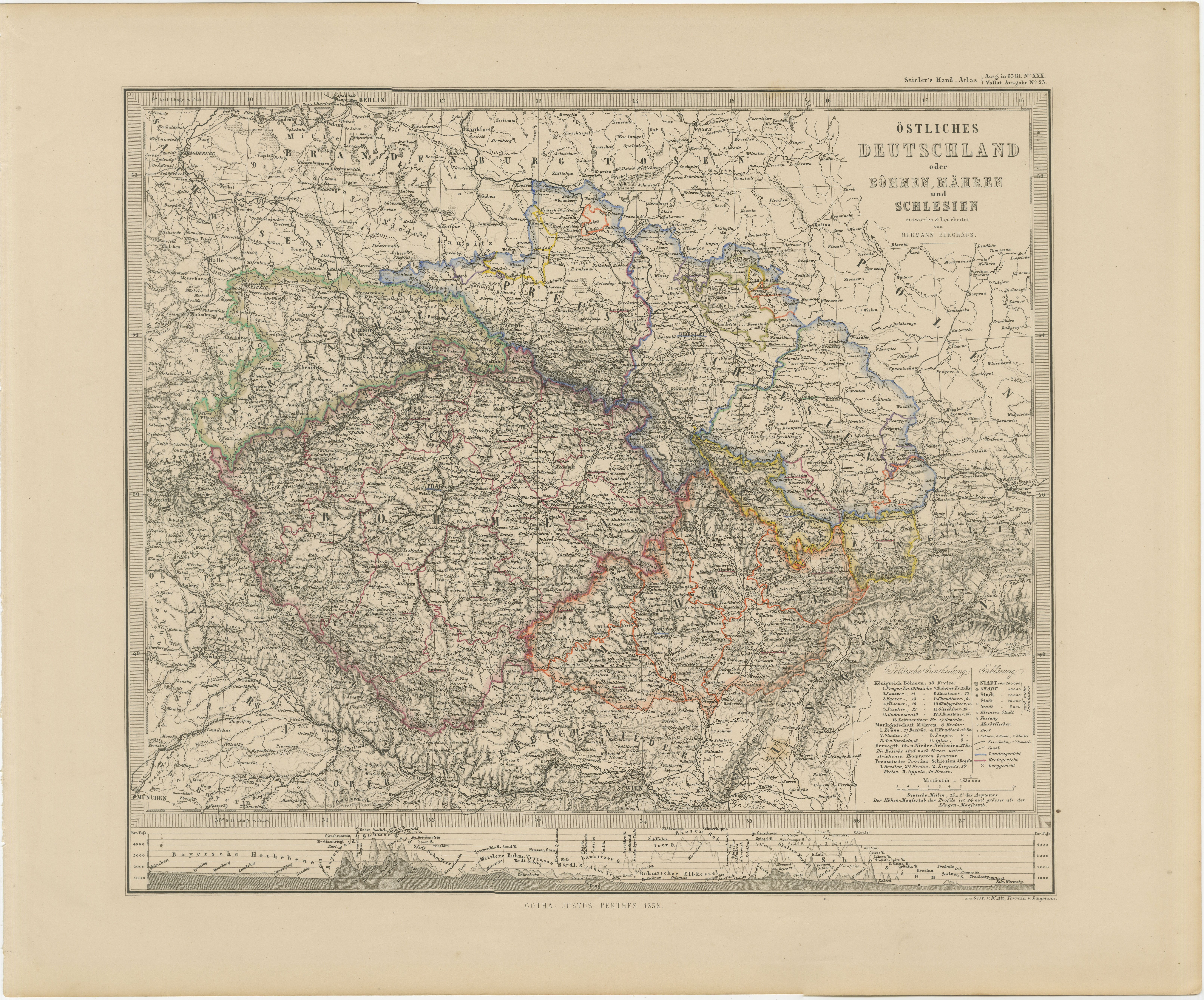
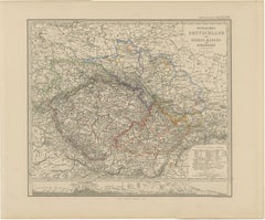
Antique Map of Eastern Germany, Bohemia, Moravia
Silesia – 1858
Located in Langweer, NL
Antique Map of Eastern Germany, Bohemia, Moravia & Silesia – 1858
Detailed 19th-century engraved map titled "Östliches Deutschland mit Böhmen, Mähren und Schlesien" (Eastern German...
Category
Antique Mid-19th Century German Maps
Materials
Paper
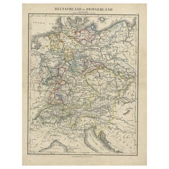
Antique Map of Germany and Switzerland from an Old Dutch School Atlas, c.1873
Located in Langweer, NL
Antique map titled 'Deutschland en Zwitserland'. Old map depicting Germany and Switzerland. This map originates from 'School-Atlas van alle Deelen der Aarde'. Artists and Engravers: ...
Category
Antique 19th Century Maps
Materials
Paper
You May Also Like
German Empire, Northern Part. Century Atlas antique vintage map
Located in Melbourne, Victoria
'The Century Atlas. German Empire, Northern Part.'
Original antique map, 1903.
Central fold as issued. Map name and number printed on the reverse corne...
Category
Early 20th Century Victorian More Prints
Materials
Lithograph

German Empire, Southwestern Part. Century Atlas antique vintage map
Located in Melbourne, Victoria
'The Century Atlas. German Empire, Southwestern Part'
Original antique map, 1903.
Central fold as issued. Map name and number printed on the reverse co...
Category
Early 20th Century Victorian More Prints
Materials
Lithograph

France, Northern Part. Century Atlas antique map
Located in Melbourne, Victoria
'The Century Atlas. France, Northern Part.'
Original antique map, 1903.
Inset maps of 'France in Provinces' and 'Paris and Vicinity'.
Central fold as issued. Map name and number pr...
Category
Early 20th Century Victorian More Prints
Materials
Lithograph

1853 Map of "Russia in Europe Including Poland" Ric.r016
Located in Norton, MA
Description
Russia in Europe incl. Poland by J Wyld c.1853
Hand coloured steel engraving
Dimension: Paper: 25 cm W x 33 cm H ; Sight: 22 cm W x 28 cm H
Condition: Good ...
Category
Antique 19th Century Unknown Maps
Materials
Paper

The Netherlands (Holland), Belgium and Luxemburg. Century Atlas antique map
Located in Melbourne, Victoria
'The Century Atlas. The Netherlands (Holland), Belgium and Luxemburg.'
Original antique map, 1903.
Inset maps of 'Amsterdam' and 'Brussels'.
Central fold as issued. Map name and num...
Category
Early 20th Century Victorian More Prints
Materials
Lithograph

Map of Germany - Original Etching - 1820
Located in Roma, IT
Map of Germany is an Original Etching realized by an unknown artist of 19th century in 1820.
Very good condition on two sheets of white paper joined at...
Category
1820s Modern Figurative Prints
Materials
Etching

More Ways To Browse
Library Collection
Railway Map
Beni Ourain Rugs
Glass Top Wood Base Coffee Tables
T Chair
Pair Of Danish Chairs
Veneer Dining Tables
1970 Italian Armchair
Furniture Uk
House Of Denmark Table And Chairs
Louis Marble Top Side Table
Antique Russian Rugs
Baker Furniture By
For Kids
Sterling Silver Flatware Set Service For 12
Tufted Bar
Pair Of French Antique Armchairs
1970s Brass Glass Coffee Table