Items Similar to Antique Map of Greece, Albania, Macedonia and Parts of Turkey and Cyprus, c.1745


Want more images or videos?
Request additional images or videos from the seller
1 of 5
Antique Map of Greece, Albania, Macedonia and Parts of Turkey and Cyprus, c.1745
$1,008.57
£752.95
€850
CA$1,401.21
A$1,507.21
CHF 805.49
MX$17,765.65
NOK 10,155.39
SEK 9,283.96
DKK 6,477.95
About the Item
Antique map titled 'Accurata Totius Archipelagi Et Graeciae Universae Tabula'.
Detailed map of Greece. Includes Albania, Macedonia and parts of Turkey and Cyprus. With compass rose and scale. Published in Amsterdam by Covens
Mortier c. 1745. Artists and Engravers: Made by 'Guillaume de l'Isle' after 'Covens
Mortier'. Guillaume Delisle (1675-1726) was a French cartographer known for his popular and accurate maps of Europe. Pieter und David Mortier were booksellers in Paris and have published a wide range of geographical works. After Pieter's death, his widow continued the business until their son Cornelius took over. Cornelius started a partnership with his brother-in-law Johannes Covens and established the famous publishing house "Covens and Mortier" in Amsterdam. They have re-issued Atlases of Sanson, de l'Isle, Visscher and de Wit.
Artist: Made by 'Guillaume de l'Isle' after 'Covens
Mortier'. Guillaume Delisle (1675-1726) was a French cartographer known for his popular and accurate maps of Europe. Pieter und David Mortier were booksellers in Paris and have published a wide range of geographical works. After Pieter's death, his widow continued the business until their son Cornelius took over. Cornelius started a partnership with his brother-in-law Johannes Covens and established the famous publishing house "Covens and Mortier" in Amsterdam. They have re-issued Atlases of Sanson, de l'Isle, Visscher and de Wit.
Condition: Good, given age. Soft crease left of lower middle fold, and a crease beside the middle fold. Original middle fold as issued. General age-related toning and/or occasional minor defects from handling. Please study image carefully.
Date: c.1745
Overall size: 65.5 x 55.5 cm.
Image size: 59.3 x 49.3 cm.
We sell original antique maps to collectors, historians, educators and interior decorators all over the world. Our collection includes a wide range of authentic antique maps from the 16th to the 20th centuries. Buying and collecting antique maps is a tradition that goes back hundreds of years. Antique maps have proved a richly rewarding investment over the past decade, thanks to a growing appreciation of their unique historical appeal. Today the decorative qualities of antique maps are widely recognized by interior designers who appreciate their beauty and design flexibility. Depending on the individual map, presentation, and context, a rare or antique map can be modern, traditional, abstract, figurative, serious or whimsical. We offer a wide range of authentic antique maps for any budget.
- Dimensions:Height: 21.86 in (55.5 cm)Width: 25.79 in (65.5 cm)Depth: 0 in (0.01 mm)
- Materials and Techniques:
- Period:
- Date of Manufacture:circa 1745
- Condition:
- Seller Location:Langweer, NL
- Reference Number:Seller: PCT-580141stDibs: LU3054326300182
About the Seller
5.0
Recognized Seller
These prestigious sellers are industry leaders and represent the highest echelon for item quality and design.
Platinum Seller
Premium sellers with a 4.7+ rating and 24-hour response times
Established in 2009
1stDibs seller since 2017
2,836 sales on 1stDibs
Typical response time: 1 hour
- ShippingRetrieving quote...Shipping from: Langweer, Netherlands
- Return Policy
More From This Seller
View AllAntique Map of Greece by Allard (c.1698)
Located in Langweer, NL
Antique map titled 'Hellas seu Graecia Universa' Detailed map of Greece, with Crete, the Aegean Islands, and part of Turkey. With two cartouches, compass rose and scale. Carolus Alla...
Category
Antique Late 17th Century Maps
Materials
Paper

$930 Sale Price
20% Off
Antique Map of Greece by Seutter or Lotter,
c.1740
Located in Langweer, NL
Antique map titled 'Graecia pars Septentrionalis'. Original antique map of Greece, uncommon. Signed cum Gratia et Privil. S.R.I. Vicariatus (..)'. Published by Seutter or Lotter, cir...
Category
Antique Mid-18th Century Maps
Materials
Paper

$654 Sale Price
35% Off
Antique Map of Greece by Keizer
de Lat, 1788
Located in Langweer, NL
Antique map titled 't Zuider Deel van Turks Europe genaamt Griekenland (..)'. Uncommon original antique map of Greece. This map originates from 'Nieuwe Natuur- Geschied- en Handelkun...
Category
Antique Late 18th Century Maps
Materials
Paper

$331 Sale Price
20% Off
Antique Engraved Map of the Northern Part of Greece and the Aegean Sea, Ca.1730
Located in Langweer, NL
Title: "GRÆCIÆ PARS Septentrionalis".
Hand Coloured Engraved map by G. Delisle of the northern part of the Aegean. In the top left corner a distance scale included.
Condition...
Category
Antique 1730s Maps
Materials
Paper
Antique Map of Eastern Mediterranean and Asia Minor by a Benedictine, c.1725
Located in Langweer, NL
Antique map titled 'Byzondere Afbeelding der Landschappen, van de Apostelen bevaren en doorwandelt om het Evangelium J. C. te Prediken.' Map of the lands travelled by the Apostles to...
Category
Antique 18th Century French Maps
Materials
Paper

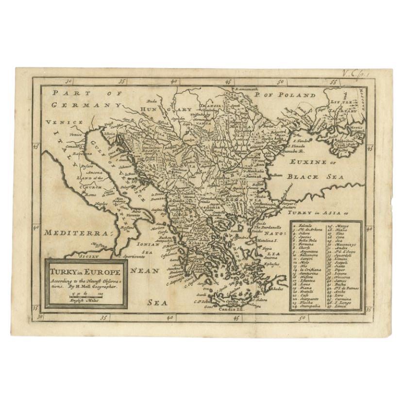
Detailed Original Antique Map of Turkey in Europe, circa 1740
Located in Langweer, NL
Antique map Turkish Empire tilted 'Turky in Europe'. Beautiful, small antique map depicting modern-day Greece and surroundings. Source unknown, to be determined.
Artists and Engra...
Category
Antique 18th Century Maps
Materials
Paper
$322 Sale Price
20% Off
You May Also Like
Greece, "Graeciae Antiquae"" A 17th Century Hand-colored Map by Sanson
By Nicolas Sanson
Located in Alamo, CA
This is an original 17th century hand colored copperplate engraved map of Greece entitled "Graeciae Antiquae Tabula Hanc Geographicam" by Nicolas d'Abbeville Sanson, engraved and pub...
Category
Antique Mid-17th Century French Maps
Materials
Paper

Original Antique Map of Ancient Greece, Achaia, Corinth, 1786
Located in St Annes, Lancashire
Great map of Ancient Greece. Showing the region of Thessaly, including Mount Olympus
Drawn by J.D. Barbie Du Bocage
Copper plate engraving by P.F Tardieu
Original hand color...
Category
Antique 1780s French Other Maps
Materials
Paper

Southern Greece: A Large 17th C. Hand-colored Map by Sanson and Jaillot
By Nicolas Sanson
Located in Alamo, CA
This large original hand-colored copperplate engraved map of southern Greece and the Pelopponese Peninsula entitled "La Moree Et Les Isles De Zante, Cefalonie, Ste. Marie, Cerigo & C...
Category
Antique 1690s French Maps
Materials
Paper

Hand-Colored 18th Century Homann Map of the Danube, Italy, Greece, Croatia
By Johann Baptist Homann
Located in Alamo, CA
"Fluviorum in Europa principis Danubii" is a hand colored map of the region about the Danube river created by Johann Baptist Homann (1663-1724) in his 'Atlas Novus Terrarum', publish...
Category
Antique Early 18th Century German Maps
Materials
Paper

18th Century Map of the Southern Balkans by Giovanni Maria Cassini
By Giovanni Maria Cassini
Located in Hamilton, Ontario
18th century map by Italian engraver Giovanni Maria Cassini (Italy 1745-1824).
Map of the Southern Balkans: Rome. Hand colored and copper engraved print done in the year 1788. It in...
Category
Antique 18th Century Italian Maps
Materials
Paper

$795 Sale Price
36% Off
Antique Map - Map of Greece - Etching by Johannes Janssonius - 1650s
By Johannes Janssonius
Located in Roma, IT
Antique Map of Greece - Graecia Vniversa is an antique map realized in 1650 by Johannes Janssonius (1588-1664).
The Map is Hand-colored etching, with coeval watercoloring.
Good co...
Category
1650s Modern Figurative Prints
Materials
Etching

More Ways To Browse
Cyprus Furniture
Antique Furniture Cyprus
Cyprus Antique Maps
Albania Antique Map
Map Of Jerusalem
Antique Maps Caribbean Islands
Antique Wine Maps
Used Furniture Wisconsin
Antique Furniture Michigan
Antique Maps Of Cape Of Good Hope
Antique Maps Of Texas
Antique Virginia Furniture
Otto Petri
American West Antiques
Antique Furniture Brunswick
Antique Map Ceylon
Antique Map Of The Philippines
Antique Mississippi Map