Want more images or videos?
Request additional images or videos from the seller
1 of 10
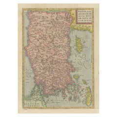
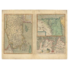
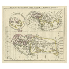
Antique Map of Greece from Ortelius
s Theatrum Orbis Terrarum, 1595
Price:$1,653.81
About the Item
- Dimensions:Height: 17.92 in (45.5 cm)Width: 21.86 in (55.5 cm)Depth: 0 in (0.02 mm)
- Materials and Techniques:Paper,Engraved
- Period:
- Date of Manufacture:1595
- Condition:Condition: Good, given age. General age-related soiling but mainly outside the image in the margins. Beautiful hand-coloured, with some creasing along the centrefold. Latin text on the reverse. Restored tear in outer lower margin; otherwise fine.
- Seller Location:Langweer, NL
- Reference Number:Seller: BG-137081stDibs: LU3054338151362
About the Seller
5.0
Recognized Seller
These prestigious sellers are industry leaders and represent the highest echelon for item quality and design.
Platinum Seller
Premium sellers with a 4.7+ rating and 24-hour response times
Established in 2009
1stDibs seller since 2017
2,811 sales on 1stDibs
Typical response time: 1 hour
Authenticity Guarantee
In the unlikely event there’s an issue with an item’s authenticity, contact us within 1 year for a full refund. DetailsMoney-Back Guarantee
If your item is not as described, is damaged in transit, or does not arrive, contact us within 7 days for a full refund. Details24-Hour Cancellation
You have a 24-hour grace period in which to reconsider your purchase, with no questions asked.Vetted Professional Sellers
Our world-class sellers must adhere to strict standards for service and quality, maintaining the integrity of our listings.Price-Match Guarantee
If you find that a seller listed the same item for a lower price elsewhere, we’ll match it.Trusted Global Delivery
Our best-in-class carrier network provides specialized shipping options worldwide, including custom delivery.You May Also Like
Large Original Antique Map of The Greek Islands. 1894
Located in St Annes, Lancashire
Superb Antique map of The Greek Islands
Published Edward Stanford, Charing Cross, London 1894
Original colour
Good condition
Unframed.
Free shipping
Category
Antique 1890s English Maps
Materials
Paper

Original Antique Map of Ancient Greece, Achaia, Corinth, 1786
Located in St Annes, Lancashire
Great map of Ancient Greece. Showing the region of Thessaly, including Mount Olympus
Drawn by J.D. Barbie Du Bocage
Copper plate engraving by P.F Tardieu
Original hand color...
Category
Antique 1780s French Other Maps
Materials
Paper

$35
Free Shipping
H 10 in W 14 in D 0.07 in
Original Antique Map of Ancient Greece- Boeotia, Thebes, 1787
Located in St Annes, Lancashire
Great map of Ancient Greece. Showing the region of Boeotia, including Thebes
Drawn by J.D. Barbie Du Bocage
Copper plate engraving by P.F T...
Category
Antique 1780s French Other Maps
Materials
Paper

$35
Free Shipping
H 10 in W 14 in D 0.07 in
1590 Ortelius Map of Calais and Vermandois, France and Vicinity Ric.a014
Located in Norton, MA
1590 Ortelius map of
Calais and Vermandois, France and Vicinity
Ric.a014
Two rare regional Abraham Ortelius maps on a single folio sheet. Left map, entitled Caletensium, depic...
Category
Antique 16th Century Dutch Maps
Materials
Paper

$1,685
H 20.08 in W 15.48 in D 0.4 in
1592 Abraham Ortelius Map "Lorraine: Lotharingiae Nova Descripti, Ric.A005
Located in Norton, MA
1592 Abraham Ortelius map entitled
"Lorraine: Lotharingiae Nova Descripti
Ric.a005
Description: Ortelius is best known for producing the atlas from which this map comes from, "...
Category
Antique 16th Century Dutch Maps
Materials
Paper

$495
H 17.01 in W 21.54 in D 0.4 in
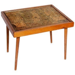
Table Low Sofa Vintage 1950s Map Isle of Man John Speed 1610 Thomas Durham 1595
Located in BUNGAY, SUFFOLK
- The juxtaposition of modern design and this ancient map create a unique small table and conversation piece
- This is the first map featuring the Isle of Man on its own.
- It is also the first map of the Island based on an actual survey, undertaken by Thomas Durham 1595 and was first published by Speed in 1605-1611 and reprinted many times over the next century. This is the second state or print from 1610.
The map is inset within a fruitwood box frame with a glass top. Supported by tapering stick legs.
The map is based on a survey (and presumably a MS map) by Thomas Durham, of whom nothing is known other that he was paid by Sir Thomas Gerrard to make a survey of the Island. This survey, almost certainly for military purposes, arose from the disputed possession of the Island during which time Elizabeth had assumed control in order to prevent the Scots or the Spanish from using the Island as a base.
Speed had used the Durham Map in his slightly earlier 4-sheet wall map showing invasions and battles of c1603/4 [ref: Shirley #261] - there are some differences from this 1605/10 map - Port Eran (rather than Earn on 1605);Knockalo point (= Contrary Hd) not on 1605;Spalbrecke shown west of Calf rather than E as on 1605/10. Thus it is possible that the Durham Map had even more detail than Speed used in his derived version.
In sea are four mythical beasts with riders: to NW of Island Unicorn with Scottish flag...
Category
Antique 1610s English Mid-Century Modern Sofa Tables
Materials
Paper
$3,442
H 16.54 in W 20.24 in D 16.54 in
1597 Abraham Ortelius Map Burgundy, France Entitled "Bvrgvndiae dvcatvs Ric.a010
Located in Norton, MA
1597 Abraham Ortelius map of Burgundy, France entitled
"Bvrgvndiae dvcatvs
Ric.a010
Description: Ortelius is best known for producing the atla...
Category
Antique 16th Century Dutch Maps
Materials
Paper

$1,455
H 13.98 in W 15.24 in D 0.4 in
Antique Map of Eastern Hemisphere from the collection of Thierry Despont
Located in New York, NY
Designed by Enrico Bonetti (E. Bonatti) and published by Francesco Vallardi Editore. Based on an earlier map by Evangelista Azzi (Ev. Azzi). Labeled as such at bottom edge of map.
T...
Category
Antique Late 19th Century Italian Maps
Materials
Canvas, Wood

$3,500
H 92 in W 95 in D 1 in
Antique Map of Principality of Monaco
By Antonio Vallardi Editore
Located in Alessandria, Piemonte
ST/619 - "Old Geographical Atlas of Italy - Topographic map of ex-Principality of Monaco" -
ediz Vallardi - Milano -
A somewhat special edition ---
Category
Antique Late 19th Century Italian Other Prints
Materials
Paper

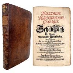
Theatrum Machinarum Generale. by Jacob Leupold - FIRST EDITION
Located in Middletown, NY
The most complete compendium on the technical sciences of the era.
Leupold, Jacob
Theatrum Machinarum Generale. Schau-Platz des Grundes Mechanischer Wissenschaften, das ist: Deutlich...
Category
Antique Early 18th Century German Books
Materials
Gold Leaf
More From This Seller
View AllAsia Minor – Antique Map of Natolia by Ortelius, Theatrum Orbis Terrarum c.1600
Located in Langweer, NL
Asia Minor – Antique Map of Natolia by Ortelius, Theatrum Orbis Terrarum c.1600
This beautifully hand-colored antique map titled Natoliae quae olim Asia Minor nova descriptio presen...
Category
Antique Early 17th Century European Maps
Materials
Paper
$423 Sale Price
20% Off
Antique Map of East Frisia by Ortelius, c.1595
Located in Langweer, NL
Antique print, titled: 'Frisia Orientalis.' Map of East Frisia originating from 'Theatrum Orbis Terrarum'. It is based on the manuscript map by Jon Bloe...
Category
Antique 16th Century Maps
Materials
Paper

Antique Map of Asia Minor, Egypt
Carthage – Ortelius Theatrum 1572
Located in Langweer, NL
Antique Map of Asia Minor, Egypt & Carthage – Ortelius Theatrum 1572
This rare and beautifully hand-colored map sheet originates from Abraham Ortelius’s groundbreaking atlas, Theatr...
Category
Antique 16th Century Belgian Maps
Materials
Paper
Antique Map of the Old World Projection, Entitled Orbis Terrarum Ad Mentem, 1825
Located in Langweer, NL
Antique map titled 'Orbis Terrarum ad Mentem (..)'. Old map of the world originating from 'Atlas der Oude Wereld'.
Artists and Engravers: Published by C. Ph. Funke and W. van Boe...
Category
Antique 19th Century Maps
Materials
Paper
$211 Sale Price
20% Off
Antique Map of Austria by Ortelius, c.1612
Located in Langweer, NL
Antique map titled 'Austriae Descrip. per Wolfgangum Lazium' Original antique map of Austria. Published by A. Ortelius, circa 1612.
Artists a...
Category
Antique 17th Century Maps
Materials
Paper
Engraving of St. Gallen and its Monastery, from Civitates Orbis Terrarum (1575)
Located in Langweer, NL
Description of the Engraving: Braun & Hogenberg’s "S. Galli Opp. et Monasterium Heluetiorum" from Civitates Orbis Terrarum (1575)
This is an original, hand-colored copper engraving ...
Category
Antique 16th Century Maps
Materials
Paper
$663 Sale Price
20% Off
Still Thinking About These?
All Recently ViewedMore Ways To Browse
Antique Plate Germany
Side Table Made In Denmark
England Antique Plates
19th Century Round Dining Table
Antique Thrones
Carved Chinese Tables
Italian Ceramic 1960s
Mid Century Modern Danish Teak Dining Tables
Rosenthal Century
Long Rug Runners
Pair Arm Chairs
Sterling Silver Dinner Sets
United Chair Company
British Antiques
Italian Beech Chairs
Shirvan Rugs
Spain Marble
Vintage Brown Bottles