Items Similar to Antique Map of Greece by Keizer
de Lat, 1788


Want more images or videos?
Request additional images or videos from the seller
1 of 5
Antique Map of Greece by Keizer
de Lat, 1788
$333.59
$416.9920% Off
£247.83
£309.7920% Off
€280
€35020% Off
CA$462.54
CA$578.1720% Off
A$497.42
A$621.7820% Off
CHF 265.97
CHF 332.4620% Off
MX$5,998.75
MX$7,498.4320% Off
NOK 3,363.39
NOK 4,204.2420% Off
SEK 3,064.48
SEK 3,830.6020% Off
DKK 2,134.07
DKK 2,667.5820% Off
About the Item
Antique map titled 't Zuider Deel van Turks Europe genaamt Griekenland (..)'. Uncommon original antique map of Greece. This map originates from 'Nieuwe Natuur- Geschied- en Handelkundige Zak- en Reisatlas' by Gerrit Brender à Brandis. Published by J. Keizer and I. de Lat, 1788.
- Dimensions:Height: 10.63 in (27 cm)Width: 8.08 in (20.5 cm)Depth: 0.02 in (0.5 mm)
- Materials and Techniques:
- Period:
- Date of Manufacture:1788
- Condition:General age-related toning. Original folding lines. Original/contemporary hand coloring, blank verso. Minor wear, please study image carefully.
- Seller Location:Langweer, NL
- Reference Number:Seller: BG-12854-171stDibs: LU3054321978792
About the Seller
5.0
Recognized Seller
These prestigious sellers are industry leaders and represent the highest echelon for item quality and design.
Platinum Seller
Premium sellers with a 4.7+ rating and 24-hour response times
Established in 2009
1stDibs seller since 2017
2,826 sales on 1stDibs
Typical response time: 1 hour
- ShippingRetrieving quote...Shipping from: Langweer, Netherlands
- Return Policy
More From This Seller
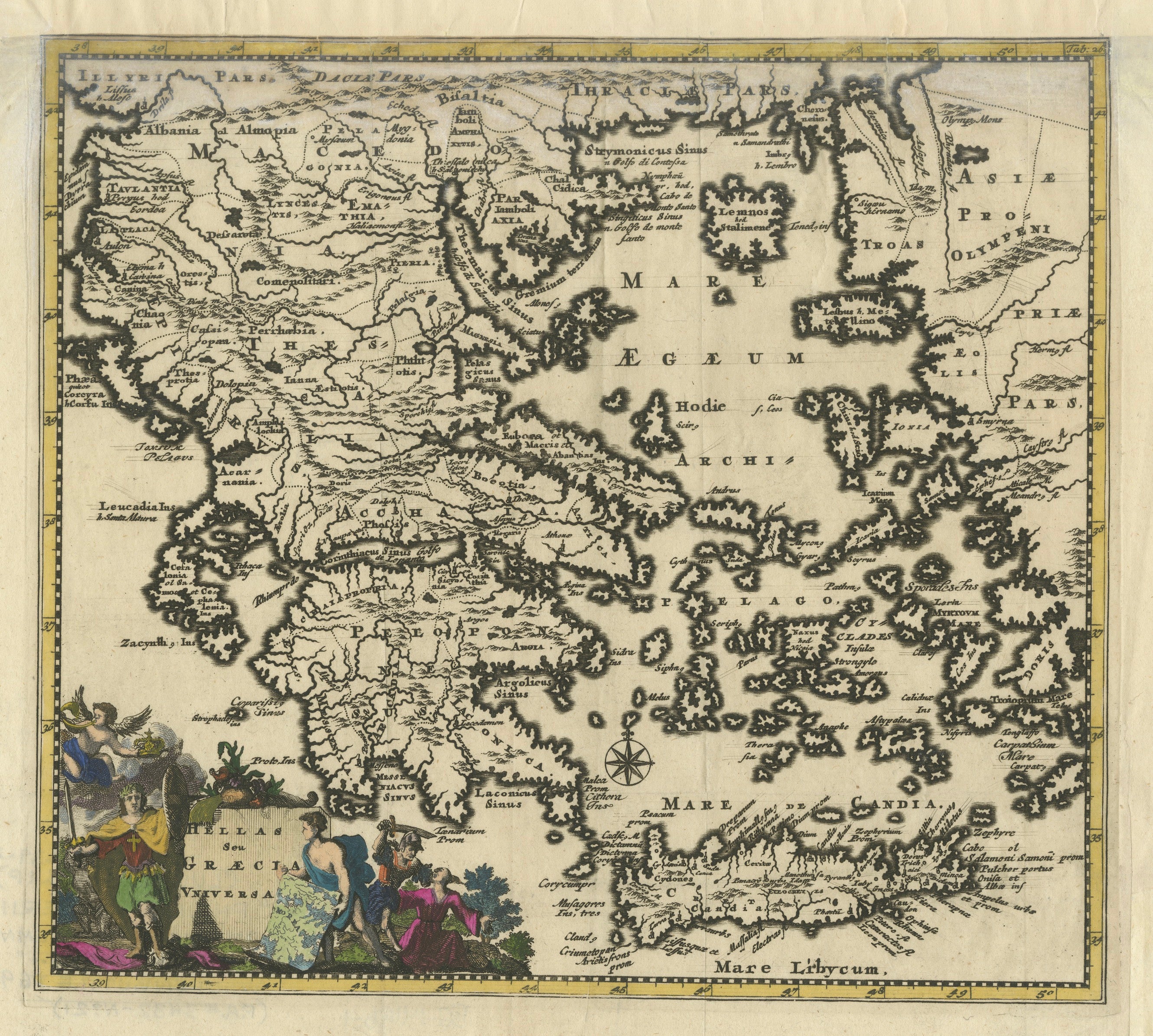
View AllAntique Map of Greece by Allard (c.1698)
Located in Langweer, NL
Antique map titled 'Hellas seu Graecia Universa' Detailed map of Greece, with Crete, the Aegean Islands, and part of Turkey. With two cartouches, compass rose and scale. Carolus Alla...
Category
Antique Late 17th Century Maps
Materials
Paper

$934 Sale Price
20% Off
Antique Map of Greece, Albania, Macedonia and Parts of Turkey and Cyprus, c.1745
Located in Langweer, NL
Antique map titled 'Accurata Totius Archipelagi Et Graeciae Universae Tabula'.
Detailed map of Greece. Includes Albania, Macedonia and parts of Turkey and Cyprus. With compass rose...
Category
Antique 18th Century Maps
Materials
Paper

Antique Map of Greece by Seutter or Lotter,
c.1740
Located in Langweer, NL
Antique map titled 'Graecia pars Septentrionalis'. Original antique map of Greece, uncommon. Signed cum Gratia et Privil. S.R.I. Vicariatus (..)'. Published by Seutter or Lotter, cir...
Category
Antique Mid-18th Century Maps
Materials
Paper

$657 Sale Price
35% Off
Antique Classical Greece Map – Aegean Sea
Crete, ca.1697
Located in Langweer, NL
Hellas seu Graecia Universa is a finely detailed late-17th-century map of Greece and the Aegean world, issued by Philipp Cluver around 1697 (possibly 1694). The map was published in ...
Category
Antique Late 17th Century Maps
Materials
Paper
Antique Map of Greece by J. Jansson, circa 1653
Located in Langweer, NL
This is an authentic antique map of the Greece by Jan Jansson. The map was published in Amsterdam, circa 1653. This striking 17th century map of Greece was based on “Totius Graeciae ...
Category
Antique Mid-17th Century Maps
Materials
Paper

$838 Sale Price
20% Off
Antique Map of Eastern Mediterranean and Asia Minor by a Benedictine, c.1725
Located in Langweer, NL
Antique map titled 'Byzondere Afbeelding der Landschappen, van de Apostelen bevaren en doorwandelt om het Evangelium J. C. te Prediken.' Map of the lands travelled by the Apostles to...
Category
Antique 18th Century French Maps
Materials
Paper

You May Also Like
Greece, "Graeciae Antiquae"" A 17th Century Hand-colored Map by Sanson
By Nicolas Sanson
Located in Alamo, CA
This is an original 17th century hand colored copperplate engraved map of Greece entitled "Graeciae Antiquae Tabula Hanc Geographicam" by Nicolas d'Abbeville Sanson, engraved and pub...
Category
Antique Mid-17th Century French Maps
Materials
Paper

Antique Map - Map of Greece - Etching by Johannes Janssonius - 1650s
By Johannes Janssonius
Located in Roma, IT
Antique Map of Greece - Graecia Vniversa is an antique map realized in 1650 by Johannes Janssonius (1588-1664).
The Map is Hand-colored etching, with coeval watercoloring.
Good co...
Category
1650s Modern Figurative Prints
Materials
Etching

Original Antique Map of Ancient Greece, Achaia, Corinth, 1786
Located in St Annes, Lancashire
Great map of Ancient Greece. Showing the region of Thessaly, including Mount Olympus
Drawn by J.D. Barbie Du Bocage
Copper plate engraving by P.F Tardieu
Original hand color...
Category
Antique 1780s French Other Maps
Materials
Paper

Map of Ancient Greece - Original Etching by Antonio Zatta - 1785
Located in Roma, IT
This Map of ancient Greek is an etching realized by Antonio Zatta in Venice in 1785.
The state of preservation of the artwork is good expect for the worn paper.
Mounted on a cardbo...
Category
1770s Landscape Prints
Materials
Etching

Southern Greece: A Large 17th C. Hand-colored Map by Sanson and Jaillot
By Nicolas Sanson
Located in Alamo, CA
This large original hand-colored copperplate engraved map of southern Greece and the Pelopponese Peninsula entitled "La Moree Et Les Isles De Zante, Cefalonie, Ste. Marie, Cerigo & C...
Category
Antique 1690s French Maps
Materials
Paper

Hand-Colored 18th Century Homann Map of the Danube, Italy, Greece, Croatia
By Johann Baptist Homann
Located in Alamo, CA
"Fluviorum in Europa principis Danubii" is a hand colored map of the region about the Danube river created by Johann Baptist Homann (1663-1724) in his 'Atlas Novus Terrarum', publish...
Category
Antique Early 18th Century German Maps
Materials
Paper

More Ways To Browse
West Indies Furniture
Railroad Collectibles
Antique Map Denmark
American West Furniture
Antique Railroad Collectibles
Gold Maps
World Map Of Trade Routes
J Walker
Mercator Map
Antique Map Of Switzerland
Albanian Antique
Antique Pamphlets
Antique Mediterranean Map
Antique Map Mexico
Antique Map Paris
Antique Puerto Rico
West Indies Antique Furniture
Map Of Ireland