Want more images or videos?
Request additional images or videos from the seller
1 of 5
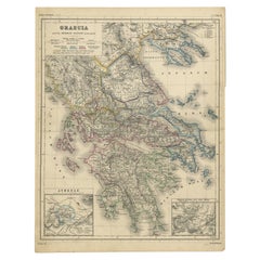
Antique Map of Greece and Surrounding Islands with an Inset Map of Troas, c.1870
Price:$225.45
About the Item
- Dimensions:Height: 13.78 in (35 cm)Width: 17.84 in (45.3 cm)Depth: 0 in (0.01 mm)
- Materials and Techniques:
- Period:
- Date of Manufacture:circa 1870
- Condition:Condition: Good, general age-related toning. Split on folding line, please study image carefully.
- Seller Location:Langweer, NL
- Reference Number:Seller: BG-06670-241stDibs: LU3054326401752
About the Seller
5.0
Recognized Seller
These prestigious sellers are industry leaders and represent the highest echelon for item quality and design.
Platinum Seller
Premium sellers with a 4.7+ rating and 24-hour response times
Established in 2009
1stDibs seller since 2017
2,836 sales on 1stDibs
Typical response time: 1 hour
Authenticity Guarantee
In the unlikely event there’s an issue with an item’s authenticity, contact us within 1 year for a full refund. DetailsMoney-Back Guarantee
If your item is not as described, is damaged in transit, or does not arrive, contact us within 7 days for a full refund. Details24-Hour Cancellation
You have a 24-hour grace period in which to reconsider your purchase, with no questions asked.Vetted Professional Sellers
Our world-class sellers must adhere to strict standards for service and quality, maintaining the integrity of our listings.Price-Match Guarantee
If you find that a seller listed the same item for a lower price elsewhere, we’ll match it.Trusted Global Delivery
Our best-in-class carrier network provides specialized shipping options worldwide, including custom delivery.You May Also Like
Original Antique Map of Ancient Greece, Achaia, Corinth, 1786
Located in St Annes, Lancashire
Great map of Ancient Greece. Showing the region of Thessaly, including Mount Olympus
Drawn by J.D. Barbie Du Bocage
Copper plate engraving by P.F Tardieu
Original hand color...
Category
Antique 1780s French Other Maps
Materials
Paper

$35
Free Shipping
H 10 in W 14 in D 0.07 in
Original Antique Map of Ancient Greece- Boeotia, Thebes, 1787
Located in St Annes, Lancashire
Great map of Ancient Greece. Showing the region of Boeotia, including Thebes
Drawn by J.D. Barbie Du Bocage
Copper plate engraving by P.F T...
Category
Antique 1780s French Other Maps
Materials
Paper

$35
Free Shipping
H 10 in W 14 in D 0.07 in
St. Christophe
St. Kitts
Island: An 18th Century Hand-colored Map by Bellin
By Jacques-Nicolas Bellin
Located in Alamo, CA
Jacques Bellin's copper-plate map of the Caribbean island of Saint Kitts entitled "Carte De De l'Isle St. Christophe Pour servir á l'Histoire Genle. des V...
Category
Antique Mid-18th Century French Maps
Materials
Paper

$575
H 10 in W 14.25 in D 0.07 in
Antique Map of Principality of Monaco
By Antonio Vallardi Editore
Located in Alessandria, Piemonte
ST/619 - "Old Geographical Atlas of Italy - Topographic map of ex-Principality of Monaco" -
ediz Vallardi - Milano -
A somewhat special edition ---
Category
Antique Late 19th Century Italian Other Prints
Materials
Paper

Large Original Antique Map of The Greek Islands. 1894
Located in St Annes, Lancashire
Superb Antique map of The Greek Islands
Published Edward Stanford, Charing Cross, London 1894
Original colour
Good condition
Unframed.
Free shipping
Category
Antique 1890s English Maps
Materials
Paper

Hand-Colored 18th Century Homann Map of Denmark and Islands in the Baltic Sea
By Johann Baptist Homann
Located in Alamo, CA
An 18th century copper plate hand-colored map entitled "Insulae Danicae in Mari Balthico Sitae utpote Zeelandia, Fionia, Langelandia, Lalandia, Falstria, Fembria Mona" created by Joh...
Category
Antique Early 18th Century German Maps
Materials
Paper

$775
H 20.25 in W 23.25 in D 0.07 in
Original Antique Map of Ireland- Tipperary and Waterford. C.1840
Located in St Annes, Lancashire
Great map of Tipperary and Waterford
Steel engraving
Drawn under the direction of A.Adlard
Published by How and Parsons, C.1840
Unframed.
Category
Antique 1840s English Maps
Materials
Paper

$35
Free Shipping
H 9.5 in W 6.25 in D 0.07 in
Southern Greece: A Large 17th C. Hand-colored Map by Sanson and Jaillot
By Nicolas Sanson
Located in Alamo, CA
This large original hand-colored copperplate engraved map of southern Greece and the Pelopponese Peninsula entitled "La Moree Et Les Isles De Zante, Cefalonie, Ste. Marie, Cerigo & C...
Category
Antique 1690s French Maps
Materials
Paper

$1,975
H 24.88 in W 38 in D 0.13 in
Hand-Colored 18th Century Homann Map of the Danube, Italy, Greece, Croatia
By Johann Baptist Homann
Located in Alamo, CA
"Fluviorum in Europa principis Danubii" is a hand colored map of the region about the Danube river created by Johann Baptist Homann (1663-1724) in his 'Atlas Novus Terrarum', publish...
Category
Antique Early 18th Century German Maps
Materials
Paper

$875
H 20 in W 23.88 in D 0.07 in
Original Antique Map of United States, Grattan and Gilbert, 1843
Located in St Annes, Lancashire
Great map of United States
Drawn and engraved by Archer
Published by Grattan and Gilbert. 1843
Original colour
Unframed.
Category
Antique 1840s English Maps
Materials
Paper

$150
Free Shipping
H 11.75 in W 10.25 in D 0.07 in
More From This Seller
View AllAntique Map of Greece with Two Small Inset Maps of Athens, c.1870
Located in Langweer, NL
Antique map titled 'Graecia'. Old map of Greece with two small inset maps of Athens. This map originates from 'Atlas Antiquus, twaalf kaarten behoorende bij de Oude Geschiedenis'. Ar...
Category
Antique 19th Century Maps
Materials
Paper
Antique Map of Scotland With an Inset Map of the Shetland Islands, 1854
Located in Langweer, NL
Stunning Map of Scotland that will look beautiful in any setting framed on the wall.
Description: Large Antique map titled 'Scotland with its Islands, drawn from the Topographical surveys...
Category
Antique 1850s Maps
Materials
Paper

Antique Map of Greece and Ionian Islands by A
C. Black, 1870
Located in Langweer, NL
Antique map titled 'Hellas or Greece'. Original antique map of Greece and Ionian Islands with inset map of Corfu. This map originates from ‘Black's General Atlas of The World’. Publi...
Category
Antique Late 19th Century Maps
Materials
Paper

$166 Sale Price
20% Off
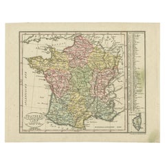
Antique Map of France with an Inset Map of the Island of Corsica, c.1820
Located in Langweer, NL
Antique map titled 'Frankrijk naar de nieuwste bepalingen meerendeels gevolgd naar Lapie'. Beautiful map of France with an inset map of the island of Corsica. Includes a table with r...
Category
Antique 19th Century Dutch Maps
Materials
Paper
$170 Sale Price
20% Off
Rare Antique Map with Timor and Nearby Islands Plus an Inset of Hawaii, 1825
Located in Langweer, NL
Antique map titled 'Essai sur la Geographie de l'Ile Timor.'
A map showing Timor and the surrounding nearby islands (Floris, Sabrao, Solor, Lomblem, Panter, Ombai and Wetter. With ...
Category
Antique 1820s French Maps
Materials
Paper
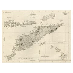
$806 Sale Price / set
20% Off
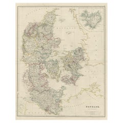
Antique Map of Denmark with an Inset Map of Iceland, 1832
Located in Langweer, NL
Antique map titled 'Denmark'. Large map of Denmark with an inset map of Iceland.
Artists and Engravers: Published by J. Arrowsmith in London, 1832.
Condition: Good, general age...
Category
Antique 19th Century Maps
Materials
Paper