Items Similar to Antique Map of the Hemelumer Oldeferd Township by Behrns, 1861


Want more images or videos?
Request additional images or videos from the seller
1 of 5
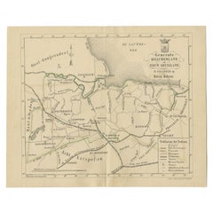
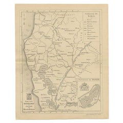
Antique Map of the Hemelumer Oldeferd Township by Behrns, 1861
$106.50
£79.55
€89
CA$146.72
A$159.90
CHF 84.68
MX$1,920.62
NOK 1,072.02
SEK 985.62
DKK 678.03
About the Item
Antique map titled 'Gemeente Hemelumer Oldephaert en Noordwolde'. Old map depicting the Hemelumer Oldeferd en Noordwolde township including cities and villages like Workum, Koudum, Hindelopen, Molkwerum, Stavoren, Warns, Elahuizen, Oudega and Hemelum. This map orginates from 'Zak-Atlas van Friesland in 36 Kaarten'.
Artists and Engravers: Published by B. Behrns, Franeker.
Condition: Good, general age-related toning. Please study image carefully.
Date: 1861
Overall size: 20.6 x 17.2 cm.
Image size: 18.4 x 15.1 cm
We sell original antique maps to collectors, historians, educators and interior decorators all over the world. Our collection includes a wide range of authentic antique maps from the 16th to the 20th centuries. Buying and collecting antique maps is a tradition that goes back hundreds of years. Antique maps have proved a richly rewarding investment over the past decade, thanks to a growing appreciation of their unique historical appeal. Today the decorative qualities of antique maps are widely recognized by interior designers who appreciate their beauty and design flexibility. Depending on the individual map, presentation, and context, a rare or antique map can be modern, traditional, abstract, figurative, serious or whimsical. We offer a wide range of authentic antique maps for any budget
- Dimensions:Height: 6.78 in (17.2 cm)Width: 8.12 in (20.6 cm)Depth: 0 in (0.01 mm)
- Materials and Techniques:
- Period:
- Date of Manufacture:1861
- Condition:
- Seller Location:Langweer, NL
- Reference Number:Seller: BG-05105-161stDibs: LU3054327796232
About the Seller
5.0
Recognized Seller
These prestigious sellers are industry leaders and represent the highest echelon for item quality and design.
Platinum Seller
Premium sellers with a 4.7+ rating and 24-hour response times
Established in 2009
1stDibs seller since 2017
2,788 sales on 1stDibs
Typical response time: <1 hour
- ShippingRetrieving quote...Shipping from: Langweer, Netherlands
- Return Policy
More From This Seller
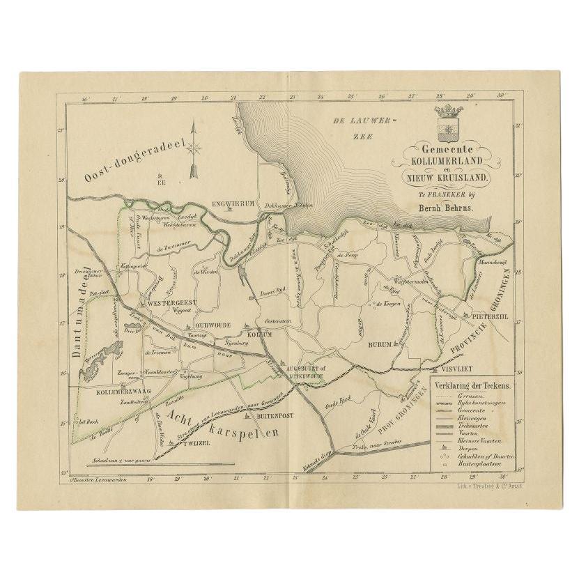
View AllAntique Map of the Kollumerland Township by Behrns, 1861
Located in Langweer, NL
Antique map titled 'Gemeente Kollumerland en Nieuw Kruisland'. Old map depicting the Kollumerland township including cities and villages like Westergeest, Kollum, Kollumerzwaag and B...
Category
Antique 19th Century Maps
Materials
Paper
Antique Map of the Lemsterland Township by Behrns, 1861
Located in Langweer, NL
Antique map titled 'Gemeente Lemsterland'. Old map depicting the Lemsterland township including cities and villages like Lemmer, Follega, Oosterzee en Echten. This map orginates from...
Category
Antique 19th Century Maps
Materials
Paper
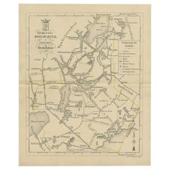
Antique Map of The Dutch Township Rauwerderhem, 1861
Located in Langweer, NL
Antique map titled 'Gemeente Rauwerderhem'. Old map depicting the Rauwerderhem township including cities and villages like Deersum, Poppingawier, Rauwerd and Irnsum. This map orginat...
Category
Antique 19th Century Maps
Materials
Paper

$114 Sale Price
20% Off
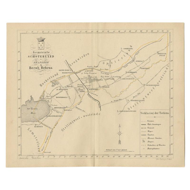
Antique Map of the Schoterland Township in Friesland, the Netherlands, 1861
Located in Langweer, NL
Antique map titled 'Gemeente Schoterland'. Old map depicting the Schoterland township including cities and villages like Rotsterhaule, Delfstrahuizen, Nieuweschoot, Mildam, Katlijk, ...
Category
Antique 19th Century Maps
Materials
Paper
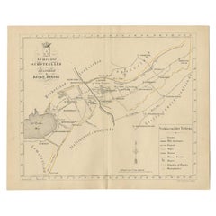
$191 Sale Price
20% Off
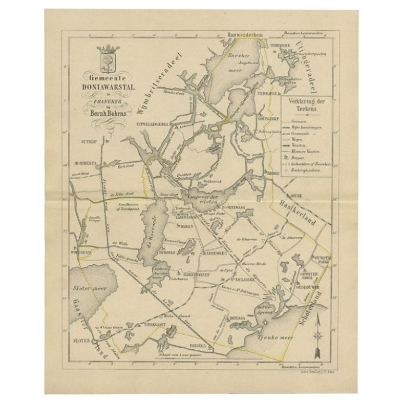
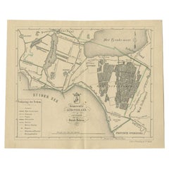
Antique Map of the Doniawerstal Township by Behrns, 1861
Located in Langweer, NL
Antique map titled 'Gemeente Doniawerstal'. Old map depicting the Doniawerstal township including cities and villages like Follega, Tjerkgaast, Legemeer, Idskenhuizen, St. Nicolaasga...
Category
Antique 19th Century Maps
Materials
Paper
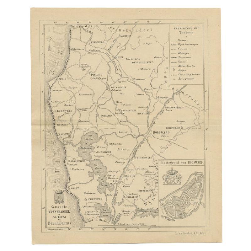
Antique Map of The Wonseradeel Township in Friesland, The Netherlands, 1861
Located in Langweer, NL
Antique map titled 'Gemeente Wonseradeel'. Old map depicting the Wonseradeel township including cities and villages like Kimswerd, Achlum, Arum, Witmarsum, Kornwerd, Hichtum and Bols...
Category
Antique 19th Century Maps
Materials
Paper
$181 Sale Price
20% Off
You May Also Like
Original Antique English County Map, Buckinghamshire, J
C Walker, 1851
Located in St Annes, Lancashire
Great map of Buckinghamshire
Original colour
By J & C Walker
Published by Longman, Rees, Orme, Brown & Co. 1851
Unframed.
Category
Antique 1850s English Other Maps
Materials
Paper

Large Original Antique Map of New York State( Southern ), USA, C.1900
Located in St Annes, Lancashire
Fabulous map of Southern New York . With a vignette of Lower Manhattan
Original color.
Engraved and printed by the George F. Cram Company, Indianapolis.
Published, C.1900.
Unfram...
Category
Antique 1890s American Maps
Materials
Paper

Original Antique Map of the American State of New York ( Western Part ) 1903
Located in St Annes, Lancashire
Antique map of New York ( Western Part )
Published By A & C Black. 1903
Original colour
Good condition
Unframed.
Free shipping
Category
Antique Early 1900s English Maps
Materials
Paper

Large Original Antique Map of New York State ( Northern ), USA, C.1900
Located in St Annes, Lancashire
Fabulous map of Northern New York
Original color.
Engraved and printed by the George F. Cram Company, Indianapolis.
Published, C.1900.
Unframed.
Repairs to minor edge tears
Fr...
Category
Antique 1890s American Maps
Materials
Paper
1891 Map of Norfolk County Massachusetts
Located in Norwell, MA
1891 map of Norfolk county Massachusetts including the towns of Wrentham, Franklin, Medfield, Sherborn, Norwood etc., measures: 23 x 31.
Category
Antique 19th Century Maps

Original Antique Map of the American State of Michigan ( Northern Part ), 1903
Located in St Annes, Lancashire
Antique map of Michigan ( Northern part )
Published By A & C Black. 1903
Original colour
Good condition
Unframed.
Free shipping
Category
Antique Early 1900s English Maps
Materials
Paper

More Ways To Browse
Large Framed Maps
Map Of Normandy
Map Of Singapore
Map Of Vienna
Missouri Map
Nantucket Map
Old School Maps
Santa Cruz Used Furniture
Ukraine Antique Map
Used Office Furniture Cincinnati
Antique Map Of Cuba
Antique Map Vietnam
Antique Maps Colorado
Antique Maps Of Kansas
Antique Marine Maps
Antique World Globe Map
Garde Corps
Marie Galante