Want more images or videos?
Request additional images or videos from the seller
1 of 5
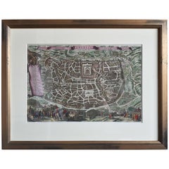
Antique Map of the Holy City Jerusalem in Israël, c.1700
Price:$360
$780.58List Price
About the Item
- Dimensions:Height: 21.26 in (54 cm)Width: 16.34 in (41.5 cm)Depth: 0 in (0.01 mm)
- Materials and Techniques:
- Period:
- Date of Manufacture:circa 1700
- Condition:Repaired: Several repairs mainly on folding lines. Condition: Fair, several repairs mainly on folding lines. Dutch text on verso, faded. Please study image carefully.
- Seller Location:Langweer, NL
- Reference Number:Seller: BG-007801stDibs: LU3054326393622
About the Seller
5.0
Recognized Seller
These prestigious sellers are industry leaders and represent the highest echelon for item quality and design.
Platinum Seller
Premium sellers with a 4.7+ rating and 24-hour response times
Established in 2009
1stDibs seller since 2017
2,813 sales on 1stDibs
Typical response time: 1 hour
Authenticity Guarantee
In the unlikely event there’s an issue with an item’s authenticity, contact us within 1 year for a full refund. DetailsMoney-Back Guarantee
If your item is not as described, is damaged in transit, or does not arrive, contact us within 7 days for a full refund. Details24-Hour Cancellation
You have a 24-hour grace period in which to reconsider your purchase, with no questions asked.Vetted Professional Sellers
Our world-class sellers must adhere to strict standards for service and quality, maintaining the integrity of our listings.Price-Match Guarantee
If you find that a seller listed the same item for a lower price elsewhere, we’ll match it.Trusted Global Delivery
Our best-in-class carrier network provides specialized shipping options worldwide, including custom delivery.You May Also Like
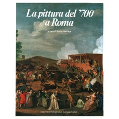
The painting of the 1700s in Rome
By Non-Standard Furniture and Lighting
Located in Milano, IT
Exemplar in good condition, in slipcase with yellowing and signs of wear. Dust jacket with yellowing, evident on spine; dust spots and signs of wear at edges and corners. Yellowed an...
Category
Vintage 1980s Italian Mid-Century Modern Books
Materials
Paper
Antique Map of American Cities, Vignette of New York City, circa 1920
Located in St Annes, Lancashire
Great maps of American Cities
Unframed
Original color
By John Bartholomew and Co. Edinburgh Geographical Institute
Published, circa 1920
Category
Vintage 1920s British Maps
Materials
Paper

$50
Free Shipping
H 18 in W 23 in D 0.07 in
Large Antique Lithography Map of Kent, English, Cartography, Robert Morden, 1700
Located in Hele, Devon, GB
This is a large antique lithography map of Kent. An English, framed atlas engraving of cartographic interest by Robert Morden, dating to the early 18th century and later.
Superb li...
Category
Antique Early 18th Century British Queen Anne Maps
Materials
Glass, Wood, Paper

$1,824
H 22.25 in W 33.08 in D 0.99 in
Italian Parchment Map of the City of Pisa Dated, 1640
By Matthäus Merian the Elder
Located in Florence, Tuscany
An antique map of the Tuscan city of Pisa engraved for The 'Itinerarium Italiæ Nov-antiquæ' by Matthäus Merian the Elder and printed in 1640....
Category
Antique 1640s Italian Maps
Materials
Paper

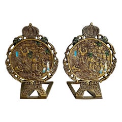
Vintage Israeli Brass Wailing Wall Jerusalem Bookends - A Pair
Located in Delray Beach, FL
Vintage Israeli Brass Jerusalem Bookends honor sacred tradition and cultural beauty with detailed Wailing Wall relief and vibrant enamel artistry.
We sell items as acquired, with...
Category
Mid-20th Century Israeli Religious Items
Materials
Brass
French topographic embossed map in three dimensions of ancient Jerusalem - 19th
Located in Bruxelles, BE
French topographic embossed map in three dimensions of Ancient Jerusalem
19th century
wood and hand-coloured plaster
10,5 x 43 x 58 cm
Provenance : Private collection UK
Wood and ...
Category
Antique 19th Century French Belle Époque Models and Miniatures
Materials
Plaster, Wood
$17,413
H 4.14 in W 16.93 in D 22.84 in
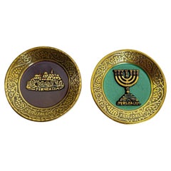
Vintage Israelis Brass Enameled Decorative Jerusalem and Menorah Plates Set of 2
Located in Delray Beach, FL
Set of two Vintage Israeli Brass Decorative Plates with enameled Jerusalem and menorah designs, perfect for display or collectible purposes.
We sell items as acquired, without res...
Category
Mid-20th Century Israeli Religious Items
Materials
Enamel
$75
H 4 in W 0.5 in D 4 in
Large Original Vintage Map of Israel, circa 1920
Located in St Annes, Lancashire
Great map of Israel
Original color.
Good condition
Published by Alexander Gross
Unframed.
Category
Vintage 1920s English Edwardian Maps
Materials
Paper

1840 Map of the City of Washington Published by William M. Morrison
Located in Colorado Springs, CO
This map, printed in 1840, is a detailed representation of Washington, D.C. in the mid-19th century. The map shows block numbers, wards, and government buildings as well as details o...
Category
Antique 1840s American Federal Maps
Materials
Paper

$3,650
H 24.75 in W 29.5 in D 1.5 in
Antique County Map, Hampshire, English, Framed Cartography, Robert Morden, 1700
Located in Hele, Devon, GB
This is an antique county map of Hampshire. An English, framed atlas engraving of cartographic interest By Robert Morden, dating to the late 17th century and later.
Superb lithogra...
Category
Antique Late 17th Century British Other Maps
Materials
Glass, Wood, Paper

$1,020
H 13.98 in W 12.41 in D 0.6 in
More From This Seller
View AllAntique Map of the City of Jerusalem by N. Visscher, 1702
Located in Langweer, NL
Antique map titled 'Die Heylige en Wytvermaerde stadt Jerusalem Eerst Genaemt Salem, Genesis 14 vers 18'. This map originates from 'Biblia. Ouden ende Nieuwen Testaments (..)'. Publi...
Category
Antique Early 18th Century Maps
Materials
Paper
$3,314 Sale Price
20% Off
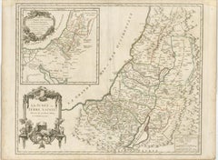
Antique French Map of the Holy Land, Twelve Tribes of Israel, c.1750
Located in Langweer, NL
Antique Holy Land Map, Twelve Tribes of Israel – Robert de Vaugondy, c.1750
Description
This finely engraved and hand-colored map depicts Judea, or the Holy Land, divided according ...
Category
Antique Mid-18th Century French Maps
Materials
Paper
Highly Detailed Antique Map of the Holy Land Showing 12 Tribes of Israel, c.1720
Located in Langweer, NL
Antique map titled 'Heylige Land verdeeld in de Twaalf Stammen Israels (..).'
Highly detailed map of the Holy Land divided into 12 tribes of Israel...
Category
Antique 1720s Maps
Materials
Paper

$461 Sale Price
20% Off
Free Shipping
Antique Detailed Map of Jerusalem in Israël with Extensive Key and Scale, 1698
Located in Langweer, NL
Antique map titled 'Jerusalem.'
Plan of the ancient city of Jerusalem. With extensive key and scale. Source unknown, to be determined.
Artists and Engravers: Made by 'Cornelis de...
Category
Antique 17th Century Dutch Maps
Materials
Paper

$624 Sale Price
20% Off
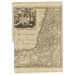
Antique Map of the Holy Land, c.1717
Located in Langweer, NL
Antique map Israel titled 'Tabula Geographica Terrae Sanctae'. Rare edition made after a map of the Holy Land by J. Bonfrerius. The map is oriented ...
Category
Antique 18th Century Maps
Materials
Paper

Antique Map of the Holy Land, c.1710
Located in Langweer, NL
Antique map titled 'Totius Terrae Sanctae Delineatio'. Map of the Holy Land extending to Egypt and showing the route of the Children of Israel in their e...
Category
Antique 18th Century Maps
Materials
Paper
Still Thinking About These?
All Recently ViewedMore Ways To Browse
Map Of Israel
Antique Maps Of Israel
Antique Map Ceylon
Antique Map Of The Philippines
Antique Mississippi Map
Celestial Map
Map Of Middle East
17th Century American Furniture
Afghanistan Map
Antique Celestial Maps
Antique Maps Virginia
Hand Drawn Map
Map Of Israel
Map Of Poland
Sicily Map
Used Durham Furniture
Antique Maps Of Israel
Antique Maps Of Russian Empire