Items Similar to Antique Map of Indonesia by C.F. Beautemps-Beaupre, circa 1807


Want more images or videos?
Request additional images or videos from the seller
1 of 5
Antique Map of Indonesia by C.F. Beautemps-Beaupre, circa 1807
$898.38
£671.78
€750
CA$1,237.74
A$1,349.93
CHF 715.10
MX$16,183.73
NOK 9,107.21
SEK 8,327.87
DKK 5,715.30
About the Item
Antique map titled 'Carte de la partie du grand archipel d'Asie'. Map of Indonesia showing tracks of Recherche and Esperance in 1792-1793. This map is part of the great archipelago of Asia, recognized by Rear Admiral Bruny-Dentrecasteaux, in 1792 and 1793. Originates from 'Atlas du voyage de Bruny-Dentrecasteaux, contre-amiral de France, commandant les fregates la Recherche et l'Esperance, fait par ordre du gouvernement en 1791, 1792 et 1793'.
- Dimensions:Height: 22.64 in (57.5 cm)Width: 33.08 in (84 cm)Depth: 0.02 in (0.5 mm)
- Materials and Techniques:
- Period:
- Date of Manufacture:circa 1807
- Condition:Some wear, please study image carefully.
- Seller Location:Langweer, NL
- Reference Number:Seller: BG-062101stDibs: LU3054312117061
About the Seller
5.0
Recognized Seller
These prestigious sellers are industry leaders and represent the highest echelon for item quality and design.
Platinum Seller
Premium sellers with a 4.7+ rating and 24-hour response times
Established in 2009
1stDibs seller since 2017
2,788 sales on 1stDibs
Typical response time: <1 hour
- ShippingRetrieving quote...Shipping from: Langweer, Netherlands
- Return Policy
More From This Seller
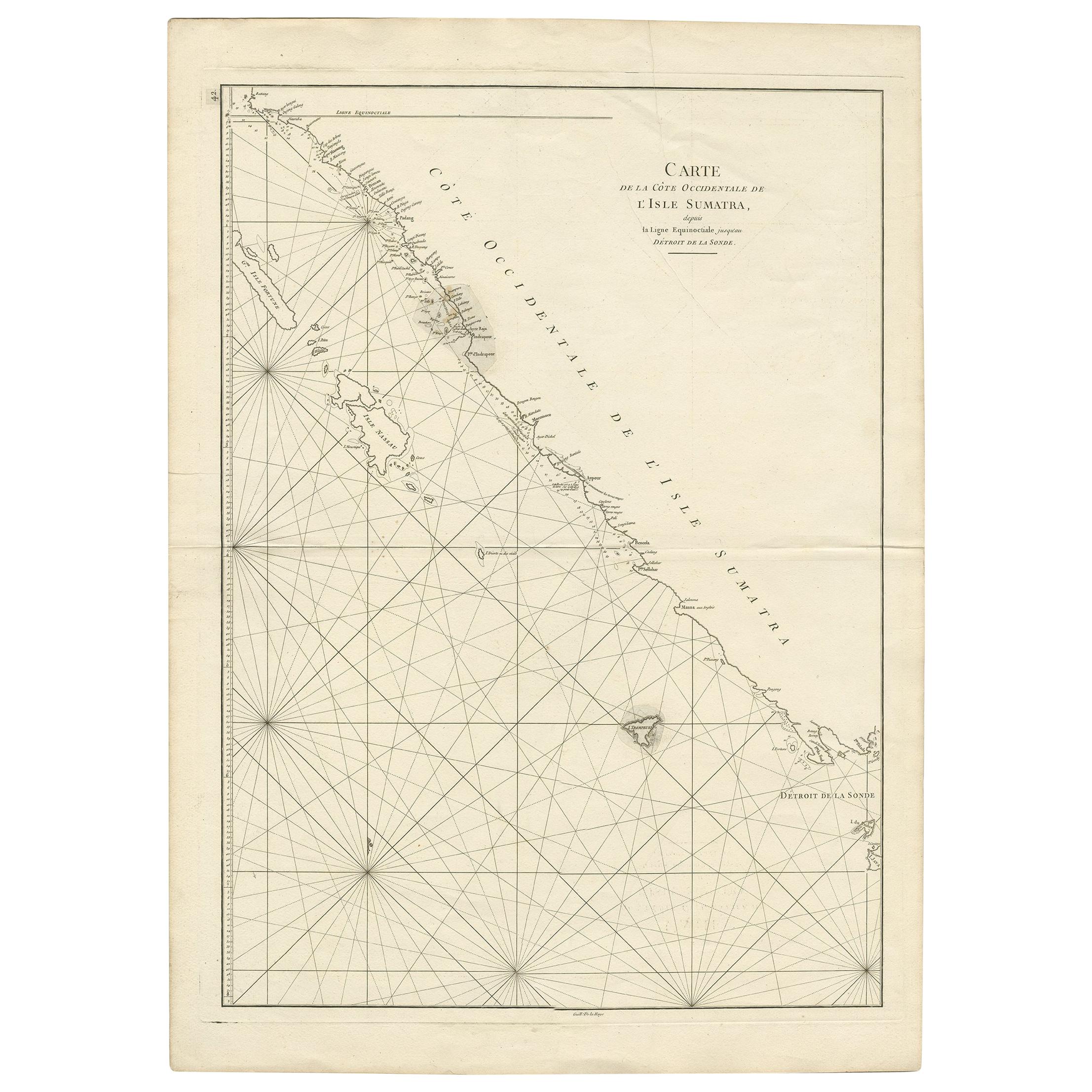
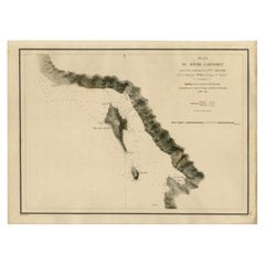
View AllAntique Map of the South-Western Coast of Sumatra by De la Haye, c.1780
Located in Langweer, NL
Antique map titled 'Carte de la Côte Occidentale de l'Isle Sumatra'. Sea chart of the part of the south-western coast of Sumatra with the Nassau (Nias) and Fortune isles.
Artists ...
Category
Antique 18th Century Maps
Materials
Paper
Antique Map of New Guinea and New Britain by P. Carteret, circa 1773
Located in Langweer, NL
Antique Map: A Chart of Captain Carteret's Discoveries at New Britain (1769)
This rare and historically significant 18th-century map, titled *A Chart of Captn Carteret's Discoveries at New Britain,* offers a fascinating glimpse into early European explorations of the Pacific. Published in 1769, the map meticulously charts Captain Philip Carteret's 1767 voyage through New Guinea and the islands of New Britain and New Ireland, showcasing his contributions to the understanding of the Bismarck Archipelago. Adding to its significance, the map traces the paths of earlier explorer William Dampier...
Category
Antique Late 18th Century Maps
Materials
Paper

$527 Sale Price
20% Off
Antique Map of the Coast of New Ireland, Earlier Part of German New Guinea, 1833
Located in Langweer, NL
Antique map titled 'Plan du Havre Carteret sur la Cote occidentale de la Nelle Irlande.
Expedition de la Corvette de S.M. l'Astrolabe, Commandee par le CAP ne de Fregate Dumont D'Urville. Juillet 1827.' A chart of the coast of Latangai Island (then known as New Ireland), with Lamassa Island (identified as Ile Cocos), and a second island identified as Ile Leigh. Shows soundings and height profile. New Ireland, also New Mecklenburg, is the Northeastern Province of Papua New Guinea. Map no. 26 from Dumont D'Urville's "Voyage de la Corvette l'Astrolabe - Atlas"", published in Paris: J. Tastu, 1833.
New Ireland or Latangai, is a large island in Papua New Guinea, approximately 7,404 km2 (2,859 sq mi) in area with c. 120,000 people. It is named after the island of Ireland. It is the largest island of New Ireland Province, lying northeast of the island of New Britain. Both islands are part of the Bismarck Archipelago, named after Otto von Bismarck...
Category
Antique 19th Century Maps
Materials
Paper
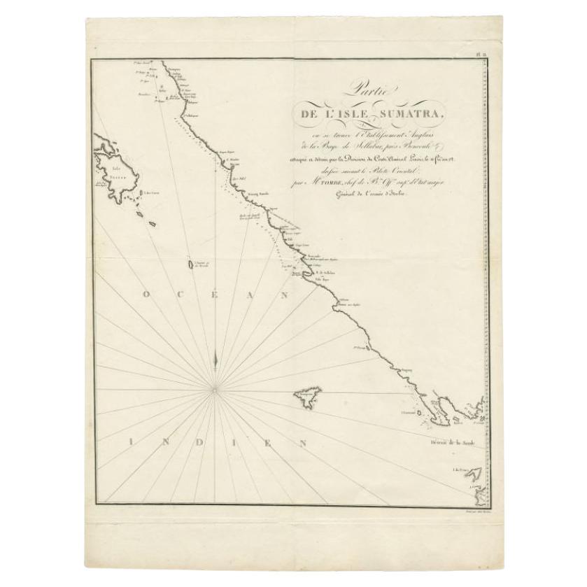
Antique Map of Sumatra by Tardieu, 1811
Located in Langweer, NL
Antique map Sumatra titled 'Partie de l'Isle Sumatra'. Part of the Island of Sumatra, where the English settlement of the Bay of Sellabar near Bencoute can...
Category
Antique 19th Century Maps
Materials
Paper
$225 Sale Price
20% Off
Antique Map of Java and Madura Island, Indonesia, c.1760
Located in Langweer, NL
Antique map titled 'Idee de l'Isle de Java.'
Well engraved and attractive chart of the island shows all principal harbors and coastal details, plus rivers, mountains and volcanoe...
Category
Antique 18th Century Maps
Materials
Paper

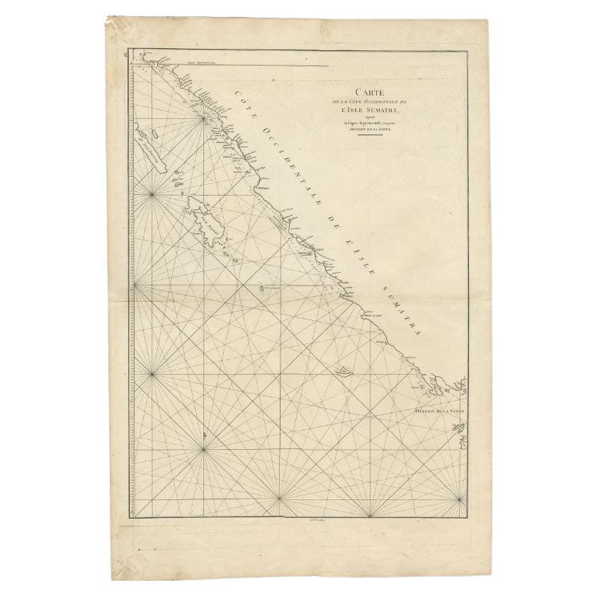
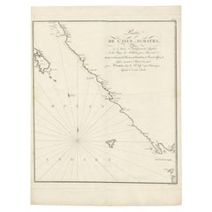
Antique Coastal Map of Sumatra by De La Haye, circa 1780
Located in Langweer, NL
Antique map titled 'Carte de la Côte Occidentale de l'Isle Sumatra'. Sea chart of the part of the south-western coast of Sumatra with the Nassau (Nias) and Fortune isles. Engraved by...
Category
Antique Late 18th Century French Maps
Materials
Paper
You May Also Like
Original Antique Map of South East Asia by Thomas Clerk, 1817
Located in St Annes, Lancashire
Great map of South East Asia
Copper-plate engraving
Drawn and engraved by Thomas Clerk, Edinburgh.
Published by Mackenzie And Dent, 1817
Unframed.
Category
Antique 1810s English Maps
Materials
Paper

Map Of The Island Of Cuba - Guillaume Thomas Raynal (1711-1796)
Located in Porto, PT
This historical map of the Island of Cuba was produced in the late 18th century and is taken from an edition of “Atlas de toutes les parties connues du globe terrestre” by the French...
Category
Antique 18th Century Prints
Materials
Glass, Paper

Antique 1803 Italian Map of Asia Including China Indoneseia India
Located in Amsterdam, Noord Holland
Antique 1803 Italian Map of Asia Including China Indoneseia India
Very nice map of Asia. 1803.
Additional information:
Type: Map
Country of Manufacturing: Europe
Period: 19th centu...
Category
Antique 19th Century European Maps
Materials
Paper

$438 Sale Price
39% Off
Antique French Map of Asia Including China Indoneseia India, 1783
Located in Amsterdam, Noord Holland
Very nice map of Asia. 1783 Dedie au Roy.
Additional information:
Country of Manufacturing: Europe
Period: 18th century Qing (1661 - 1912)
Condition: Overall Condition B (Good Used)...
Category
Antique 18th Century European Maps
Materials
Paper

$486 Sale Price
40% Off
Large Original Antique Map of Java and Borneo, Fullarton, C.1870
Located in St Annes, Lancashire
Great map of Java and Borneo
Wonderful figurative borders
From the celebrated Royal Illustrated Atlas
Lithograph. Original color.
Published by Fullarton, Edinburgh. C.1870
Unfr...
Category
Antique 1870s Scottish Maps
Materials
Paper

Large Original Antique Map of The Canary Islands. 1894
Located in St Annes, Lancashire
Superb Antique map of The Canary Islands
Published Edward Stanford, Charing Cross, London 1894
Original colour
Good condition
Unframed.
Free shipping
Category
Antique 1890s English Maps
Materials
Paper

More Ways To Browse
Indonesia Map
Antique Maps Indonesia
Antique Furniture Plans
Antique Maps Of Africa
Antique Map India
Antique Map Of The South Of France
Antique English Maps
Indonesia Map
Ancient Maps
Antique Mining
Antique Atlas Furniture
Antique Maps Indonesia
Map Of India
China Map
Victorian Furniture 1920
Antique Maps Amsterdam
Antique Maps Of Russia
19th Century Map Of Africa