Items Similar to Antique Map of Italy by Andriveau-Goujon, 1843

Want more images or videos?
Request additional images or videos from the seller
1 of 12
Antique Map of Italy by Andriveau-Goujon, 1843
$3,350per set
£2,550.95per set
€2,937.36per set
CA$4,747.24per set
A$5,106.34per set
CHF 2,728.98per set
MX$60,189.21per set
NOK 34,406.01per set
SEK 31,453.62per set
DKK 21,947.01per set
About the Item
Antique Map of Italy by Andriveau-Goujon, 1843. Map of Italy in two parts by Andriveau-Goujon for the Library of Prince Carini at Palazzo Carini in Palermo, circa 1843. In excellent condition on two panels, dissected and mounted on original linen in 32 sections. Comes with original marbleized cardboard slipcase in rich purple and orange and paper label of the Prince of Carini.
Map dimensions in two parts; each of the two sections measures 38.5" W x 26.25" L for a total overall dimension of 38.5 W x 52.5 L. Box dimensions: 5.5" W x 1.5" D x 7" H.
- Creator:Andriveau-Goujon (Maker)
- Dimensions:Height: 0.38 in (9.66 mm)Width: 38.5 in (97.79 cm)Depth: 52.5 in (133.35 cm)
- Sold As:Set of 2
- Materials and Techniques:
- Place of Origin:
- Period:
- Date of Manufacture:1843
- Condition:Wear consistent with age and use. Excellent antique condition.
- Seller Location:New York, NY
- Reference Number:1stDibs: LU108421930732
About the Seller
4.9
Platinum Seller
Premium sellers with a 4.7+ rating and 24-hour response times
Established in 1993
1stDibs seller since 2014
612 sales on 1stDibs
Typical response time: <1 hour
- ShippingRetrieving quote...Shipping from: New York, NY
- Return Policy
More From This Seller
View AllMap of the Republic of Genoa
Located in New York, NY
Framed antique hand-coloured map of the Republic of Genoa including the duchies of Mantua, Modena, and Parma.
Europe, late 18th century.
Dimension: 25...
Category
Antique Late 18th Century European Maps

Pair Antique Italian Maps of the North American Eastern Seaboard
Located in New York, NY
Pair antique Italian maps of the North American Eastern Seaboard. Late 18th early 19th century original Italian documentation of the East Coast of the United States from Passamaquadd...
Category
Antique Late 18th Century Italian Maps
Materials
Wood, Paper

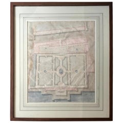
Palazzo Andrea Doria, Genoa Landscape Watercolour
Located in New York, NY
Watercolor Landscape Study of the Palazzo Andrea Doria, Genoa. Antique French architectural study of the plan and gardens of the Doria Palace in Genoa, en...
Category
Antique Early 19th Century French Drawings
Materials
Paper
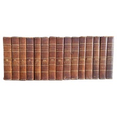
Inverary Set of Fifteen Leather Bound Books
Located in New York, NY
Inverary set of fifteen leather bound books. The Annual Register or A View of the History, Politics, and Literature for the year comprising the years 1765-1792: volume 8, 9, 10, 11,...
Category
Antique 18th Century English Books
Materials
Leather, Paper
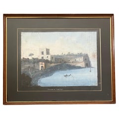
Sepolgro di Agreppina, Neapolitan Guoache, 1790’s
Located in New York, NY
Sepolgro di Agreppina, Neapolitan Guoache, 1790’s
Early guoache view of the sepulchre tomb complex of Agrippina along the coast outside Naples. The mother of Nero and wife of Emperor...
Category
Antique Late 18th Century Italian Paintings
Materials
Paint
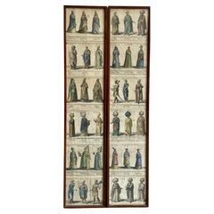
Pair Framed Antique Engravings of Ottoman Personages
Located in New York, NY
Pair framed antique engravings of ottoman personages. Set of 12 hand coloured antique engravings of 36 diverse personages of Ottoman and Oriental background spectacularly attired in ...
Category
Antique Early 18th Century European Prints
Materials
Paper
You May Also Like
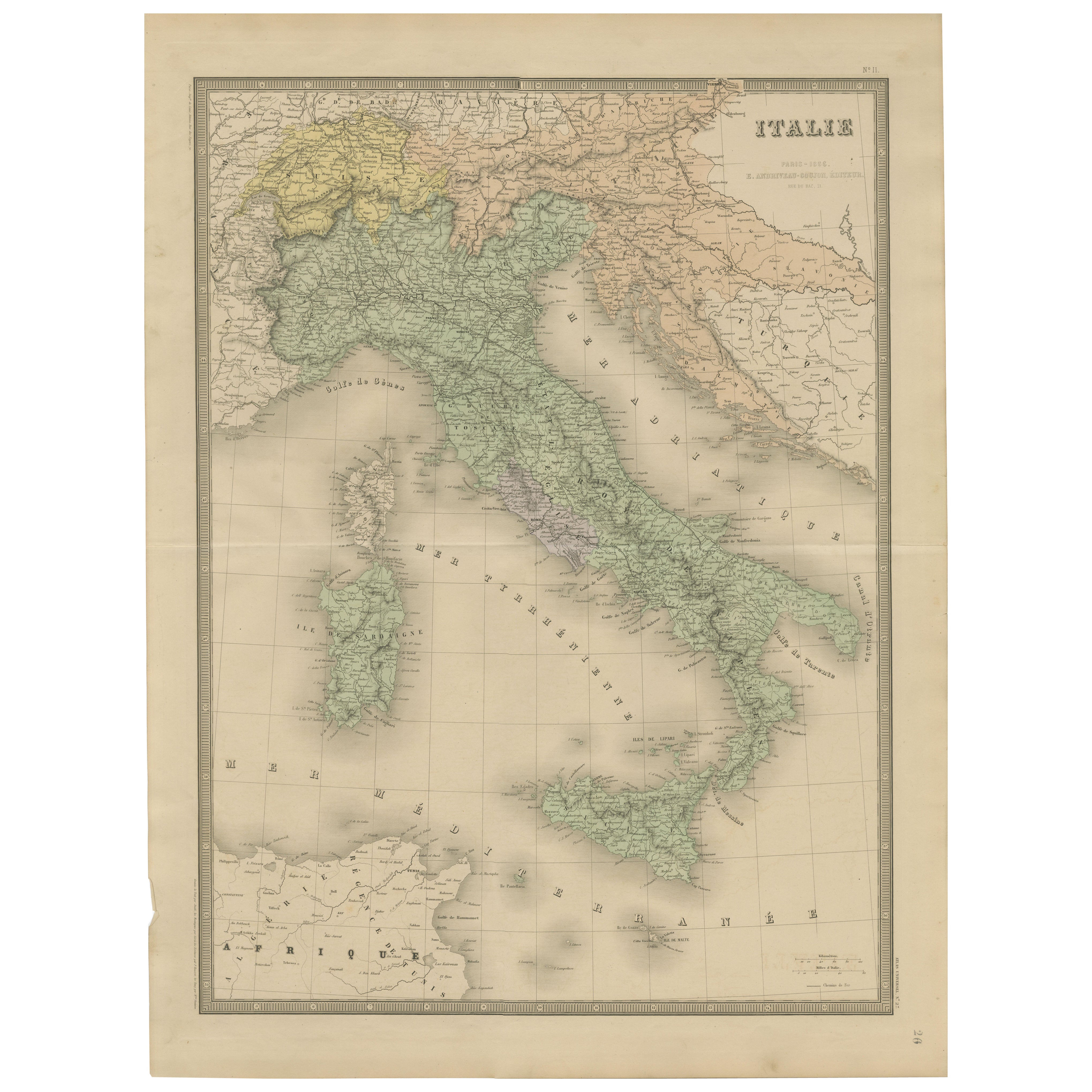
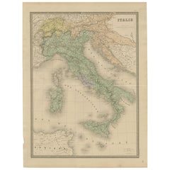
Antique Map of Italy – Pre-Unification Italy by Andriveau-Goujon, Paris 1861
Located in Langweer, NL
Antique Map of Italy – Pre-Unification Italy by Andriveau-Goujon, Paris 1861
This antique map of Italy, titled simply “Italie,” was published in Paris in 1861 by E. Andriveau-Goujon...
Category
Antique Mid-19th Century French Maps
Materials
Paper
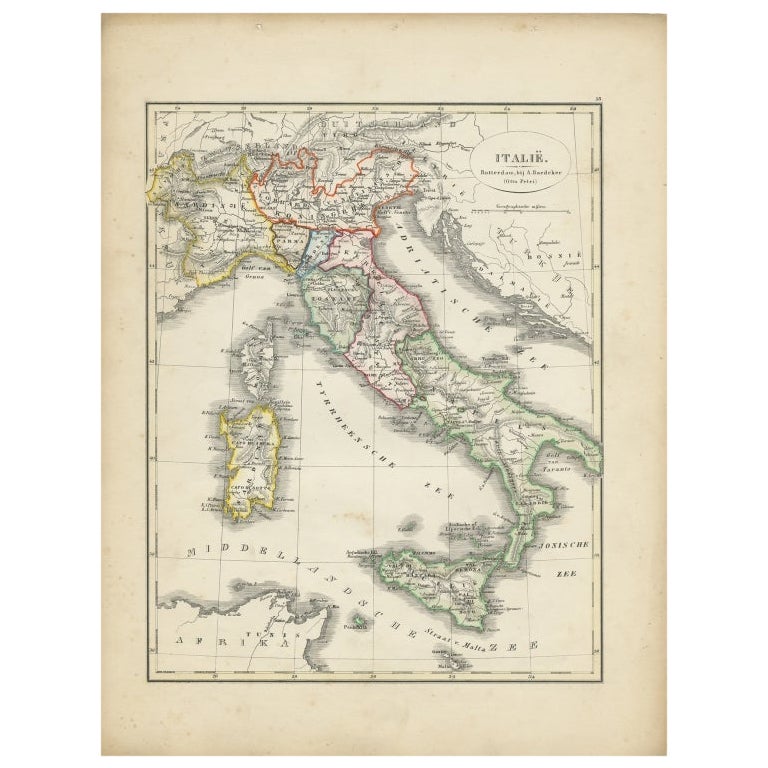
Antique Map of Italy with Hand-Colored Borders, 1852
Located in Langweer, NL
Antique map titled 'Italië'. Map of Italy. This map originates from 'School-Atlas van alle deelen der Aarde' by Otto Petri. Artists and Engravers: Published by A. Baedeker (Otto Petr...
Category
Antique 19th Century Maps
Materials
Paper

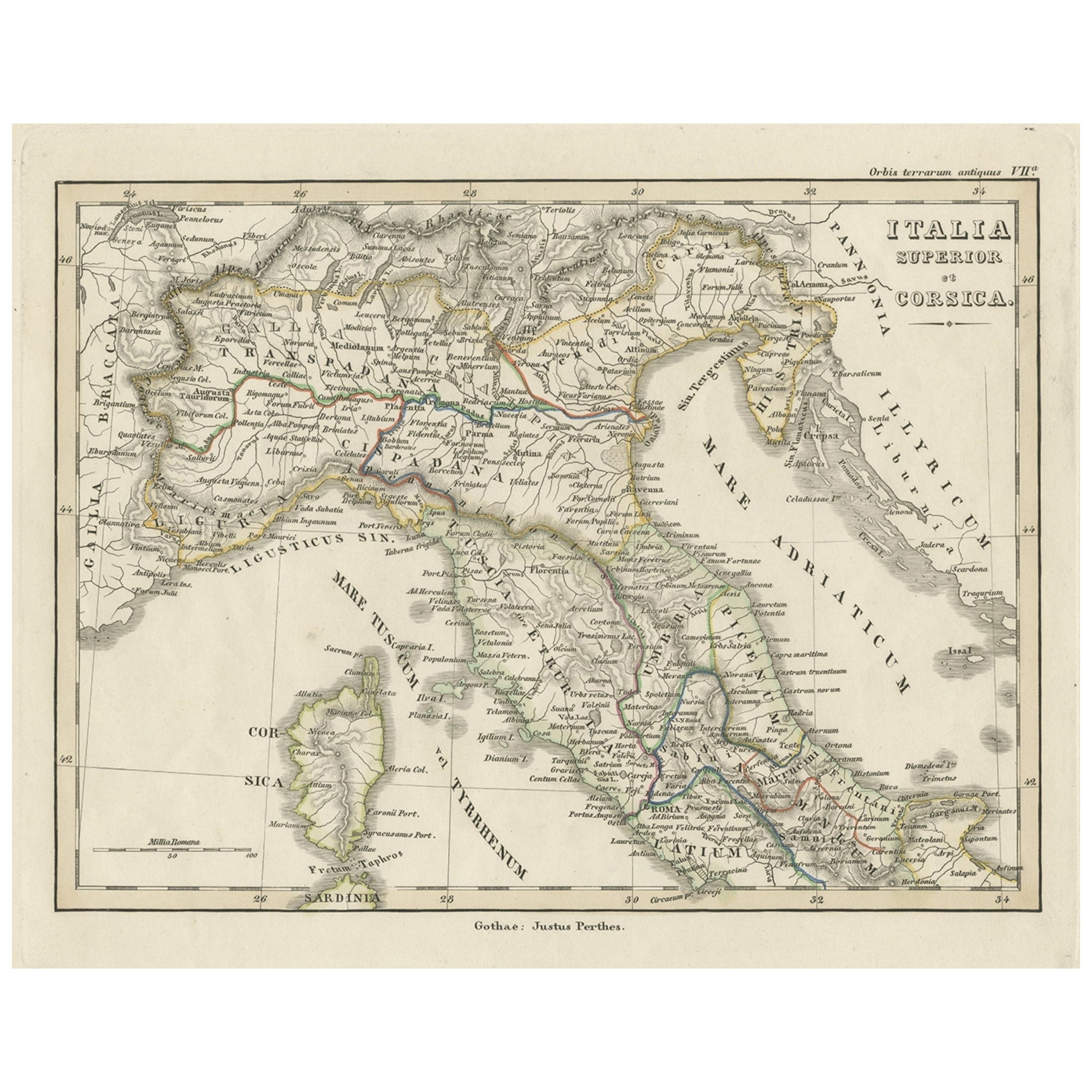
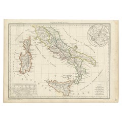
Antique Map of Italy and Corse in Ancient Times, 1848
Located in Langweer, NL
Antique map titled 'Italia Superior et Corsica'.
Old map of northern Italy and Corse originating from 'Orbis Terrarum Antiquus in usum Scholarum'. Artists and Engravers: Publishe...
Category
Antique 19th Century Maps
Materials
Paper

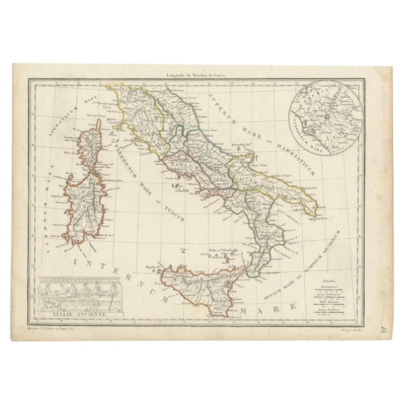
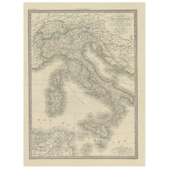
Antique Map of Italy with an Inset of Rome, 1812
Located in Langweer, NL
Antique map titled 'Italie Ancienne'.
Old map of ancient Italy, with an inset map of the region of Rome. This map originates from 'Atlas Supplementaire du Precis de la Geographie...
Category
Antique 19th Century Maps
Materials
Paper
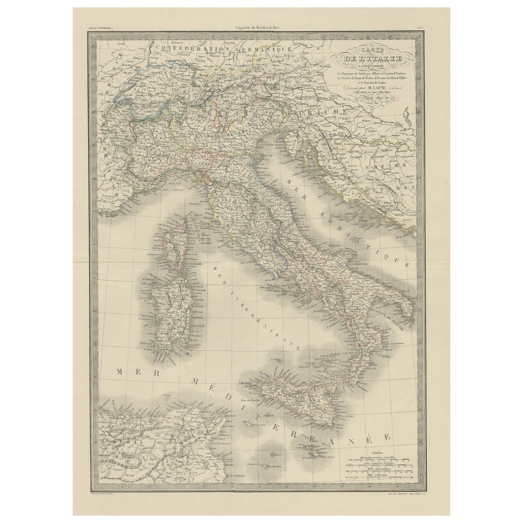
Antique Map of Italy from an Old French Atlas, 1842
Located in Langweer, NL
Antique map titled 'Carte de l'Italie'. Map of Italy.
This map originates from 'Atlas universel de géographie ancienne et moderne (..)' by Pierre M. Lapie and Alexandre E. Lapie. A...
Category
Antique 19th Century French Maps
Materials
Paper
Antique Map of Italy, Showing Corsica, Sardinia, Croatia, Malta and More, C.1740
Located in Langweer, NL
Antique map titled 'Nieuwe Kaart van Italie na de Nieuwste waarnemingen van de l'Isle en andere.'
Attractive detailed map showing Italy as well as Corsica, Sardinia, Minorca, Croat...
Category
Antique 18th Century Maps
Materials
Paper

More Ways To Browse
Antique Maps Of Italy
Antique Linen Map
Blaeu Maps
Antique Topographic Maps
Antique Maps Of North America
Antique Maps Of Italy
Antique Navigator
Antique Maps Of Britain
Wood Furniture Bali
Scotland Map
Antique Maps Scotland
Furniture Russian 18th Century
Antique Map Of Middle East
London Antique Maps
Map Colorful
Maps Of Australia
Antique Railroad Furniture
Map Of London