1 of 3
An Antique Map Of Italy
$2,000List Price
About the Item
- Dimensions:Height: 36 in (91.44 cm)Width: 30 in (76.2 cm)
- Place of Origin:
- Period:
- Date of Manufacture:DATED DEC.19 1789
- Condition:
- Seller Location:Toronto, CA
- Reference Number:1stDibs: U1110228755239
Authenticity Guarantee
In the unlikely event there’s an issue with an item’s authenticity, contact us within 1 year for a full refund. DetailsMoney-Back Guarantee
If your item is not as described, is damaged in transit, or does not arrive, contact us within 7 days for a full refund. Details24-Hour Cancellation
You have a 24-hour grace period in which to reconsider your purchase, with no questions asked.Vetted Professional Sellers
Our world-class sellers must adhere to strict standards for service and quality, maintaining the integrity of our listings.Price-Match Guarantee
If you find that a seller listed the same item for a lower price elsewhere, we’ll match it.Trusted Global Delivery
Our best-in-class carrier network provides specialized shipping options worldwide, including custom delivery.You May Also Like
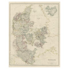
Antique Map of Denmark with an Inset Map of Iceland, 1832
Located in Langweer, NL
Antique map titled 'Denmark'. Large map of Denmark with an inset map of Iceland.
Artists and Engravers: Published by J. Arrowsmith in London, 1832.
Condition: Good, general age...
Category
Antique 19th Century Maps
Materials
Paper
Antique Map of Eastern Canada with an inset Map of Newfoundland, 1882
Located in Langweer, NL
Antique map titled 'Dominion of Canada'. Old map of Eastern Canada with an inset map of Newfoundland. This map originates from 'The Royal Atlas of Modern Geography, Exhibiting, in a ...
Category
Antique 19th Century Maps
Materials
Paper

$336
H 19.49 in W 24.1 in D 0 in
Antique Map of Scotland With an Inset Map of the Shetland Islands, 1854
Located in Langweer, NL
Stunning Map of Scotland that will look beautiful in any setting framed on the wall.
Description: Large Antique map titled 'Scotland with its Islands, drawn from the Topographical surveys...
Category
Antique 1850s Maps
Materials
Paper

$1,501
H 31.19 in W 22.92 in D 0 in
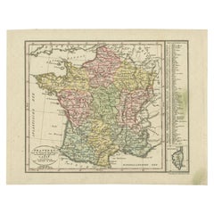
Antique Map of France with an Inset Map of the Island of Corsica, c.1820
Located in Langweer, NL
Antique map titled 'Frankrijk naar de nieuwste bepalingen meerendeels gevolgd naar Lapie'. Beautiful map of France with an inset map of the island of Corsica. Includes a table with r...
Category
Antique 19th Century Dutch Maps
Materials
Paper
$172 Sale Price
20% Off
H 9.45 in W 12.21 in D 0 in
Antique Map of Asia by with an Inset Map of Turkey in Asia, 1868
Located in Langweer, NL
Antique map Asia titled 'Carte Politique et Ethnographique d'Asie'. Old map of Asia with an inset map of Turkey in Asia. Includes descriptive text box...
Category
Antique 19th Century Maps
Materials
Paper

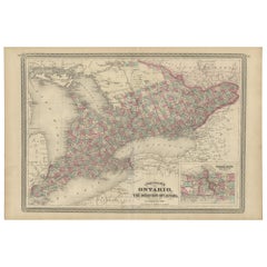
Antique Map of Ontario with an Inset Map of the Niagara River by Johnson, 1872
Located in Langweer, NL
Antique map titled 'Johnson's Ontario, of the dominion of Canada (..)'. Original map of Ontario, Canada, with an inset map of the Niagara River and vicinity. This map originates from...
Category
Antique Late 19th Century Maps
Materials
Paper
$240 Sale Price
20% Off
H 18.12 in W 26.58 in D 0.02 in
French Antique Map of India with an Inset of Pondicherry, 1835
Located in Langweer, NL
Antique map India titled 'Presqu'ile de l'Inde en de ca du Gange'. Miniature map depicting India with an inset map of Pondicherry (Puducherry). This ...
Category
Antique 19th Century Maps
Materials
Paper
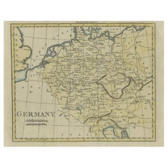
Antique Map of Germany from an Old English Atlas, c.1802
Located in Langweer, NL
Antique map titled 'Germany'. Antique map of Germany engraved for 'Atlas to Walker's Geography'. Artists and Engravers: Engraved by W. Darton.
Artist: Engraved by W. Darton.
Co...
Category
Antique 19th Century Maps
Materials
Paper
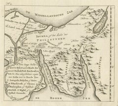
Antique Map of Edom, an Ancient Kingdom in Transjordan, 1773
Located in Langweer, NL
Antique print titled 'Idumea, of thet Land der Philistynen'. Old map of Edom, an ancient kingdom in Transjordan located between Moab to the northeast, the Arabah to the west and the ...
Category
Antique 18th Century Maps
Materials
Paper
Antique Map of Italy by Pierre M. Lapie, Paper Print, Mid-19th Century
Located in Langweer, NL
Antique map titled 'Carte de l'Italie Ancienne'. Map of Italy. This map originates from 'Atlas universel de géographie ancienne et moderne (..)' by Pierre...
Category
Antique Mid-19th Century French Maps
Materials
Paper

$480 Sale Price
20% Off
H 26.78 in W 19.89 in D 0.02 in
Still Thinking About These?
All Recently ViewedMore Ways To Browse
J Harrison
Antique Russian Rugs
For Kids
Sterling Silver Flatware Set Service For 12
Tufted Bar
Pair Of French Antique Armchairs
1970s Brass Glass Coffee Table
Charles Rennie Mackintosh For Cassina
Glass Salt
Italian Modern Silver Vases
Vintage Resin Tables
Antique English Country Furniture
Blue Kilim Vintage
Contemporary Side Tables And Stools
Decorative Wall Plate
Mid Century Modern Corner Chair
Dining Tables With Brass Inlay
Oak Mid Century Armchair