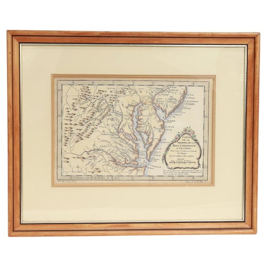
Items Similar to Antique Map of Kamchatka by Bellin,
1757


Want more images or videos?
Request additional images or videos from the seller
1 of 5
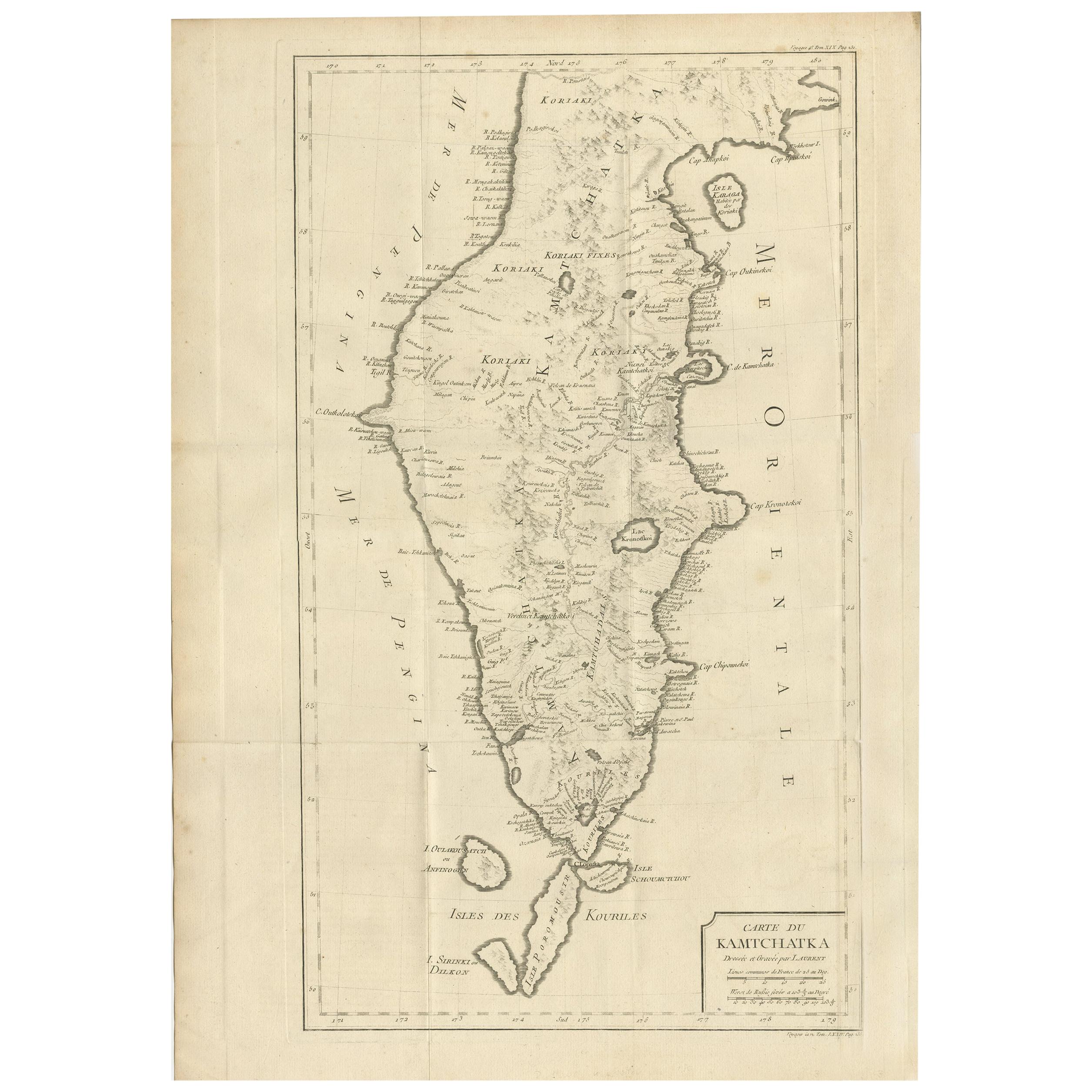
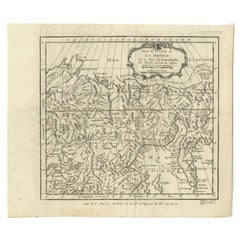
Antique Map of Kamchatka by Bellin,
1757
$336.28
£249.10
€280
CA$460.11
A$500.64
CHF 265.08
MX$6,023.04
NOK 3,365.96
SEK 3,079.62
DKK 2,133.83
About the Item
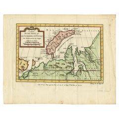
Antique map titled 'Carte du Kamtchatka'. Antique map of the Kamchatka Peninsula. The map includes the island of Ouiakous Atch ou Anfinogen, Schoumctchou, and Sirinki ou Dilkon. Originates from Prévost's 'Histoire Générale des Voyages'. Engraved by J. Laurent. Published by J.N. Bellin.
- Creator:Jacques-Nicolas Bellin (Artist)
- Dimensions:Height: 21.66 in (55 cm)Width: 13.19 in (33.5 cm)Depth: 0.02 in (0.5 mm)
- Materials and Techniques:
- Period:
- Date of Manufacture:1757
- Condition:Wear consistent with age and use. Few light stains, please study images carefully.
- Seller Location:Langweer, NL
- Reference Number:Seller: BGJC-00751stDibs: LU3054314421361
Jacques-Nicolas Bellin
Jacques Nicolas Bellin (1703 –1772) was a French hydrographer (official cartographer) and a geographer. While still a teenager he became the chief cartographer to the French Navy and later to the king of France. Bellin created a large number of maps for Antoine François Prévost's (L'Abbe Prevost) 'Histoire Generale des Voyages', which was a 25 volume publication focused on 17th and 18th century exploration.It was published in French, Dutch and German. He also contributed maps and articles to the 35-volume Encyclopédie edited by Denis Diderot and Jean le Rond d'Alembert. He was part of the group called Philosophes, which included many of the great intellectuals of the Age of Enlightenment, including Voltaire, Rousseau and Montesquieu. Bellin died at Versailles in 1772.
About the Seller
5.0
Recognized Seller
These prestigious sellers are industry leaders and represent the highest echelon for item quality and design.
Platinum Seller
Premium sellers with a 4.7+ rating and 24-hour response times
Established in 2009
1stDibs seller since 2017
2,816 sales on 1stDibs
Typical response time: 1 hour
- ShippingRetrieving quote...Shipping from: Langweer, Netherlands
- Return Policy
More From This Seller
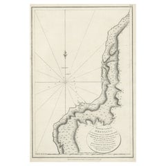
View AllAntique Map of the Kamchatka Peninsula by Bellin, 1757
By J. Laurent
Located in Langweer, NL
Antique map titled 'Carte du Kamtchatka'. Antique map of the Kamchatka Peninsula. The map includes the island of Ouiakous Atch ou Anfinogen, Schoumctchou, and Sirinki ou Dilkon. Orig...
Category
Antique 18th Century Maps
Materials
Paper
Antique Map of Kamtchatka by Didot,
1759
Located in Langweer, NL
Antique map titled 'Carte du Kamtchatka'. Antique map of the Kamchatka Peninsula. The map includes the island of Ouiakous Atch ou Anfinogen, Schoumctchou, and Sirinki ou Dilkon. Orig...
Category
Antique Mid-18th Century Maps
Materials
Paper
$288 Sale Price
20% Off
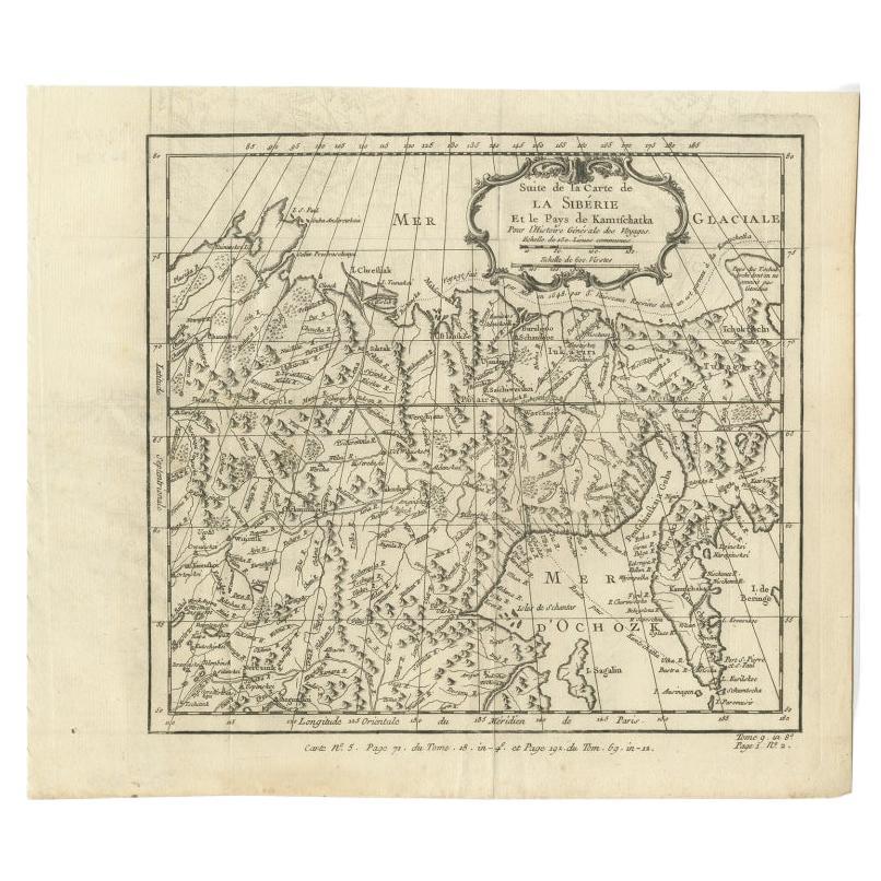
Antique Map of Eastern Siberia Extending to Kamtchatka, Russia, 1764
By Jacques-Nicolas Bellin
Located in Langweer, NL
Antique map titled 'Suite De La Carte De La Siberie Et le Pays de Kamtchatka'. Detailed map the Eastern portion of Siberia, extending to Kamtchatka. Shows the Russian voyage of 1648 in the NE Passage region. Includes a decorative title cartouche. Originates from Prevost d'Exiles influential travel book, 'L'Histoire Generale des Voyages'.
Artists and Engravers: Jacques-Nicolas Bellin (1703-1772) was among the most important mapmakers of the eighteenth century. In 1721, at age 18, he was appointed hydrographer (chief cartographer) to the French Navy. In August 1741, he became the first Ingénieur de la Marine of the Depot des cartes...
Category
Antique 18th Century Maps
Materials
Paper
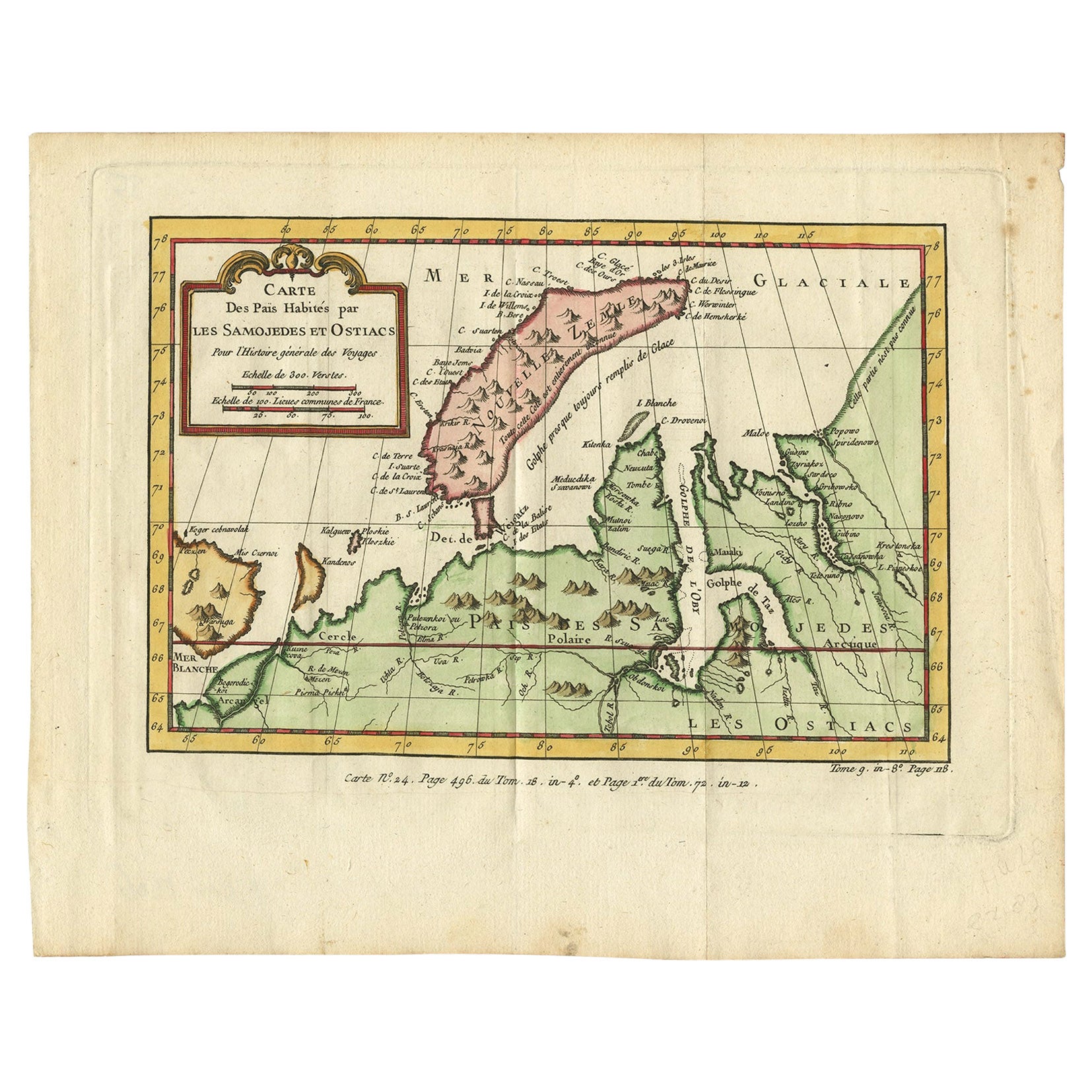
Antique Map of Novaya Zemlya and the Russian Mainland by Bellin, c.1760
Located in Langweer, NL
Antique map titled 'Carte Des Pais Habites par les Samojedes et Ostiacs.' Map of Novaya Zemlya and the Russian mainland. Source unknown, to be determined. Artists and Engravers: Made...
Category
Antique 18th Century Maps
Materials
Paper
Antique Map of Nova Zembla ‘Russia’ by J.N. Bellin, 1758
Located in Langweer, NL
An interesting map of Nova Zembla and surrounding areas. With details on the eastern tip of Nova Zembla of the place where the stranded Dutch sailors under Willem Barentsz spent the ...
Category
Antique Mid-18th Century Maps
Materials
Paper

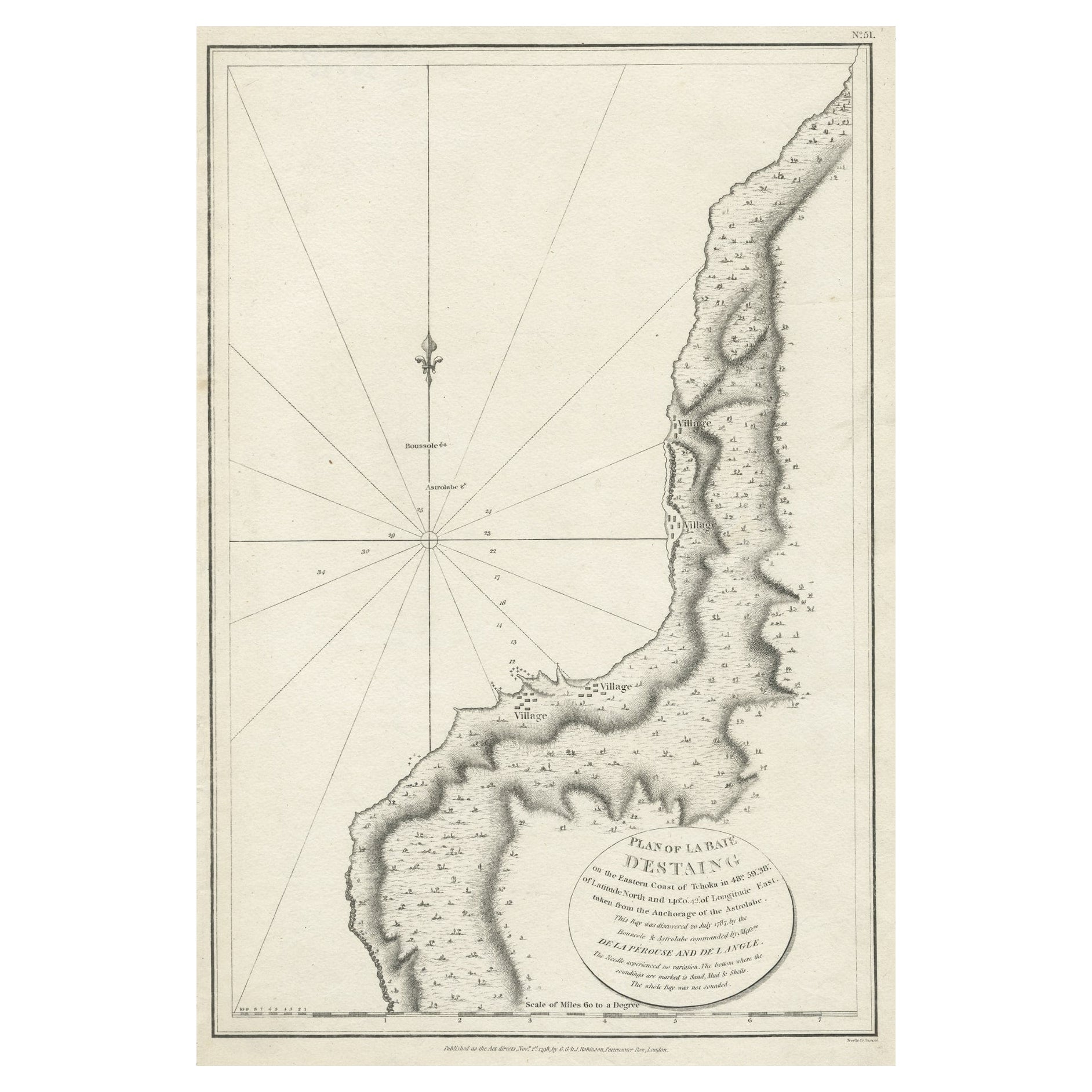
Antique Map of The Bay of D
Estaing located on the Russian island Sakhalin, 1798
Located in Langweer, NL
Antique map titled 'Plan of La Baie d'Estaing'.
This map shows the bay of D'Estaing located on the Russian island of Sakhalin. La Perouse was selected b...
Category
Antique 1790s Maps
Materials
Paper
$345 Sale Price
20% Off
You May Also Like
1790 Thomas Stackhouse Map, Entitled "Russia in Europe, " , Ric.a004
Located in Norton, MA
1790 Thomas Stackhouse map, entitled
"Russia in Europe"
Ric.a004
Stackhouse, Thomas
Russia in Europe [map]
London: T. Stackhouse, 1783. Map. Matted hand-colored copper engraving. Image size: 14.5 x 15.25 inches. Mat size: 22.75 x 23.75 inches. A beautiful example of this map of Eastern Europe...
Category
Antique 17th Century Unknown Maps
Materials
Paper

1646 Jansson Map Entitled "Procinvia Connactiae, " Ric.a006
Located in Norton, MA
1646 Jansson map entitled
"Procinvia connactiae,"
Ric.a006
Description: The PROVINCE of CONNAVGT 490 x 380From vol 4 of Jansson's Atlas Novus 1646, published in Amsterdam with...
Category
Antique 17th Century Unknown Maps
Materials
Paper

1849 Map of "Europaische Russland",
Meyer Map of European Russia
, Ric. R017
Located in Norton, MA
1849 Map of
"Europaische Russland"
( Meyer Map of European Russia)
Ric.r017
A lovely map of European Russia dating to 1849 by Joseph Meyer. It covers the European portions of...
Category
Antique 19th Century Unknown Maps
Materials
Paper

1814 Map of "Russian Empire" Ric.r032
Located in Norton, MA
1814 Map of
"Russian Empire"
Ric.r032
Russian Empire. Description: This is an 1814 John Thomson map of the Russian Empire. The map depicts the region from the Baltic Sea, Prussia, and Sweden to the Aleutian Islands and from the Arctic Ocean to the Yellow River. Highly detailed, myriad cities, towns, and villages are labeled throughout, including St. Petersburg, Moscow, Minsk, Kiev, and Kharkov. Rivers and mountain ranges are also identified, as are islands and numerous locations along the coastlines. It is important to note that the long-disputed sea between Korea and Japan is identified as the 'Sea of Japan.
Historical Context:
In 1815, Tsarist Russia emerged from the Napoleonic Wars economically insolvent and politically fearful of the Revolutionary fervor that had just swept through Europe. In order to shore up Russia's economic position, the Tsars began an aggressive series of expansions into the Caucuses and Central Asia that would vastly increase the landmass of the Russian Empire.
Publication History
Thomson maps are known for their stunning color, awe inspiring size, and magnificent detail. Thomson's work, including this map, represents some of the finest cartographic art...
Category
Antique 19th Century Unknown Maps
Materials
Paper

Original Antique Map of Ancient Greece, Achaia, Corinth, 1786
Located in St Annes, Lancashire
Great map of Ancient Greece. Showing the region of Thessaly, including Mount Olympus
Drawn by J.D. Barbie Du Bocage
Copper plate engraving by P.F Tardieu
Original hand color...
Category
Antique 1780s French Other Maps
Materials
Paper

1636 Jansson Map of Ireland Entitled "Comitatus Lageniae, " Ric.a007
Located in Norton, MA
1646 Jansson map entitled
"Procinvia connactiae,"
Ric.a006
Description: The PROVINCE of CONNAVGT 490 x 380From vol 4 of Jansson's Atlas Novus 1646, published in Amsterdam with...
Category
Antique 17th Century Unknown Maps
Materials
Paper

More Ways To Browse
Antique English Maps
Indonesia Map
Ancient Maps
Antique Mining
Antique Atlas Furniture
Antique Maps Indonesia
Map Of India
China Map
Victorian Furniture 1920
Antique Maps Amsterdam
Antique Maps Of Russia
19th Century Map Of Africa
Map Of Britain
Antique Oregon
Bali Wood
Railroad Furniture
Antique Malaysia
Blaeu Maps