Want more images or videos?
Request additional images or videos from the seller
1 of 6
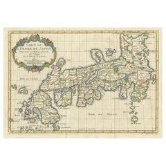
Antique Map of Kyoto
Japan
Published in 1833
Price:$2,402
$3,003.12List Price
About the Item
- Dimensions:Height: 27.96 in (71 cm)Width: 39.77 in (101 cm)Depth: 0.02 in (0.5 mm)
- Materials and Techniques:
- Period:
- Date of Manufacture:1833
- Condition:Wear consistent with age and use. Professionaly restored, mounted on paper. Please study images carefully.
- Seller Location:Langweer, NL
- Reference Number:Seller: BG-117741stDibs: LU3054315760402
About the Seller
5.0
Recognized Seller
These prestigious sellers are industry leaders and represent the highest echelon for item quality and design.
Platinum Seller
Premium sellers with a 4.7+ rating and 24-hour response times
Established in 2009
1stDibs seller since 2017
2,819 sales on 1stDibs
Typical response time: 1 hour
Authenticity Guarantee
In the unlikely event there’s an issue with an item’s authenticity, contact us within 1 year for a full refund. DetailsMoney-Back Guarantee
If your item is not as described, is damaged in transit, or does not arrive, contact us within 7 days for a full refund. Details24-Hour Cancellation
You have a 24-hour grace period in which to reconsider your purchase, with no questions asked.Vetted Professional Sellers
Our world-class sellers must adhere to strict standards for service and quality, maintaining the integrity of our listings.Price-Match Guarantee
If you find that a seller listed the same item for a lower price elsewhere, we’ll match it.Trusted Global Delivery
Our best-in-class carrier network provides specialized shipping options worldwide, including custom delivery.You May Also Like
London 1744 Published Watercolour Antique Map of East Africa by Eman Bowen
Located in West Sussex, Pulborough
We are delighted to offer for sale this New and Accurate Map of Nubia & Abissinia, together with all the Kingdoms Tributary Thereto, and bordering upon them published in 1744 by Emanuel Bowen
This is a decorative antique engraved map of East Africa...
Category
Antique 1740s English George III Maps
Materials
Paper

$1,309
H 17.52 in W 21.07 in D 0.79 in
Antique Paterson
s Guide to Britain, English, Maps, Georgian, Published 1811
Located in Hele, Devon, GB
This is an antique copy of Paterson's New and Accurate guide to Direct & Principal Crossroads. An English, bound book of maps and descriptive tables, published in English by Longman,...
Category
Antique Early 19th Century British Georgian Books
Materials
Paper

$880
H 7.49 in W 4.73 in D 1.58 in
1840 Map of the City of Washington Published by William M. Morrison
Located in Colorado Springs, CO
This map, printed in 1840, is a detailed representation of Washington, D.C. in the mid-19th century. The map shows block numbers, wards, and government buildings as well as details o...
Category
Antique 1840s American Federal Maps
Materials
Paper

$3,650
H 24.75 in W 29.5 in D 1.5 in
1870 "Johnson
s Europe" Map Published by A. J. Johnson
Located in Colorado Springs, CO
Presented is an original 1870 "Johnson’s Europe" map. First published in 1864, this map was issued as pages 87 and 88 in the 1870 edition of “Johnson's New Illustrated (Steel Plate) ...
Category
Antique 1870s American Victorian Maps
Materials
Paper

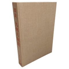
Japanese Porcelain Reference Book Ancient Ceramics of Kyushu - Kyoto Shoin, 1963
Located in Amsterdam, Noord Holland
Ancient Ceramics of Kyushu
Nagatake, Takeshi
Tokyo, Japan: Toko Shoin, 1963.
Hardcover. dark cream linen boards w/ blind-stamped emblem & orange script. approx 400+ pgs w/ bw illust...
Category
20th Century Books
Materials
Paper
$485
H 0.04 in W 0.04 in D 0.04 in
Antique Map of Principality of Monaco
By Antonio Vallardi Editore
Located in Alessandria, Piemonte
ST/619 - "Old Geographical Atlas of Italy - Topographic map of ex-Principality of Monaco" -
ediz Vallardi - Milano -
A somewhat special edition ---
Category
Antique Late 19th Century Italian Other Prints
Materials
Paper

1842 Wall Map of the United States by J. H. Young, Published by S. A. Mitchell
Located in Colorado Springs, CO
Presented is an 1842 hanging “Map of the United States,” engraved by J. H. Young and published by Samuel Augustus Mitchell, Philadelphia. This is a beautiful example of the rare 1842...
Category
Antique 1840s American Maps
Materials
Paper

$5,500
H 45 in W 38 in D 1 in
1866 "Johnson
s United States" Map, Published by Johnson and Ward
Located in Colorado Springs, CO
Presented is a detailed map of the United States by A. J. Johnson. Spanning the whole of the continental United States, as well as adjacent parts of Canada and Mexico, the map reflec...
Category
Antique 1860s American Victorian Maps
Materials
Paper

Large Original Vintage Map of Japan, circa 1920
Located in St Annes, Lancashire
Great map of Japan
Original color. Good condition
Published by Alexander Gross
Unframed.
Category
Vintage 1920s English Maps
Materials
Paper

Large Original Vintage Map of Japan, circa 1920
Located in St Annes, Lancashire
Great map of Japan
Unframed
Original color
By John Bartholomew and Co. Edinburgh Geographical Institute
Published, circa 1920
Free shipping.
Category
Vintage 1920s British Maps
Materials
Paper

More From This Seller
View AllOriginal Antique Map of Southern Asia, Published in 1833
Located in Langweer, NL
Antique map titled 'Carte de l'Inde'. Detailed map extending from India in the west to Vietnam and the Malay Peninsula in the east. This map originates from 'Atlas universel de geogr...
Category
Antique Mid-19th Century Maps
Materials
Paper

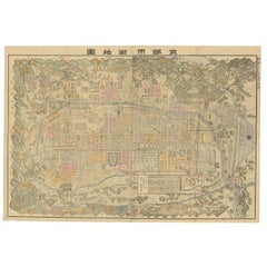
Historical Large Map of Kyoto, Japan (1905) - Published by Kobayashi
Located in Langweer, NL
Old map of Kyoto, Japan. Published by Kobayashi, 1905.
This is an old map of Kyoto, Japan, published by Kobayashi in 1905. The map showcases a detailed layout of Kyoto during the ea...
Category
Early 20th Century Maps
Materials
Paper
$1,681 Sale Price
20% Off
Free Shipping
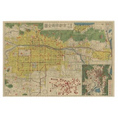
Antique Folding Map of Kyoto, Japan, 1920
Located in Langweer, NL
Antique folding map of Kyoto, Japan. On the verso of this map photos of buildings, other structures and informative text can be found.
Category
20th Century Maps
Materials
Paper
Attractive Hand-Tinted Antique Map of Japan, Published in 1752
Located in Langweer, NL
Nice decorative hand tinted map of Japan with the title (in French): Carte de L'Empire du Japon Bellin, 1752
This antique map is engraved with very attractive title cartouche.
...
Category
Antique 1750s Maps
Materials
Paper
Antique Map of the Region of Delhi in India, 1833
Located in Langweer, NL
Antique map titled 'India IX'. Old steel engraved map of the region of Delhi, with great detail.
Artists and Engravers: Engraved by J. & C. Walker. Published under the superinten...
Category
Antique 19th Century Maps
Materials
Paper
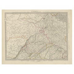
$384 Sale Price
20% Off
Original Antique Map of Iowa, Published in 1881
Located in Langweer, NL
Antique map titled 'Iowa'. Original antique map of Iowa, United States. This print originates from 'Encyclopaedia Britannica', Ninth Edition. Published 188...
Category
Antique Late 19th Century English Maps
Materials
Paper
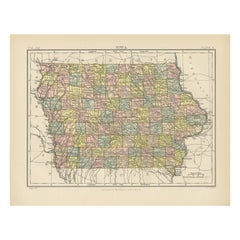
$278 Sale Price
20% Off
Still Thinking About These?
All Recently ViewedMore Ways To Browse
Map Of Japan
Antique English Maps
Indonesia Map
Ancient Maps
Antique Mining
Antique Atlas Furniture
Antique Maps Indonesia
Map Of India
China Map
Victorian Furniture 1920
Antique Maps Amsterdam
Antique Maps Of Russia
19th Century Map Of Africa
Map Of Britain
Antique Oregon
Bali Wood
Railroad Furniture
Antique Malaysia