Items Similar to Antique Map of Lot, France – Hand-Colored Engraving by Vuillemin, c.1850


Want more images or videos?
Request additional images or videos from the seller
1 of 9
Antique Map of Lot, France – Hand-Colored Engraving by Vuillemin, c.1850
$263.16
£195.41
€220
CA$361.57
A$393.25
CHF 208.41
MX$4,711.98
NOK 2,648.77
SEK 2,426.64
DKK 1,677.30
About the Item
Antique Map of Lot, France – Hand-Colored Engraving by Vuillemin, c.1850
This beautifully engraved 19th-century map of the French department of Lot was created by the notable French cartographer Alexandre Vuillemin and published circa 1850 in Paris. It forms part of his acclaimed *Atlas Départemental de la France*, a richly illustrated series of maps celebrating the geography, culture, and history of France’s departments.
The map of Lot is outlined in a soft orange border, with major rivers, roads, and towns carefully rendered. Several routes are highlighted in color, most likely referencing postal roads or railways of the period. Towns and communes are labeled with remarkable clarity, giving insight into the dense settlement patterns and regional importance of this southwestern area of France.
What makes this map particularly appealing are its decorative vignettes and historical references. In the upper left corner is a view of the Château de Fénelon, a medieval castle linked to the famous theologian and writer François Fénelon. The lower left features the arms of the Arrondissement de Cahors. In the bottom right corner is a framed illustration of Generals Jean-Baptiste Bessières and Joachim Murat, both born in Lot and prominent figures in Napoleonic military history. A portrait of Murat also adorns the upper right corner, adding a personal and patriotic element to the cartography.
This map serves both as a visual and historical document, combining geography with iconography and local pride. The style is characteristically mid-19th century, with delicate hand-coloring, precision engraving, and typographic elegance. A perfect piece for collectors of antique maps, French regional history, or Napoleonic memorabilia.
Key locations labeled on the map include:
1. Cahors
2. Figeac
3. Gourdon
4. Gramat
5. Souillac
6. Saint-Céré
7. Puy-l’Évêque
8. Cajarc
9. Castelnau-Montratier
10. Montcuq
11. Bretenoux
12. Labastide-Murat
13. Luzech
14. Lacapelle-Marival
15. Vayrac
16. Martel
17. Livernon
18. Assier
19. Biars-sur-Cère
20. Prayssac
21. Espère
22. Le Montat
23. Saint-Géry
24. Saint-Sozy
25. Saint-Médard-de-Presque
26. Vers
27. Floirac
28. Saint-Projet
29. Crayssac
30. Douelle
31. Salviac
32. Labastide-du-Haut-Mont
33. Saint-Pierre-Toirac
34. Béduer
35. Catus
36. Bagnac-sur-Célé
37. Themines
38. Alvignac
39. Saint-Matré
40. Gigouzac
41. Gignac
42. Carlucet
43. Peyrilles
44. Frayssinet
45. Rampoux
46. Saint-Martin-le-Redon
47. Saint-Cirq-Lapopie
48. Pescadoires
49. Calvignac
50. Aujols
Condition report:
Good condition with wide margins and mild age toning. Minor scattered foxing in outer margin, not affecting printed area. Hand-coloring remains vibrant. Plate mark visible. No tears or repairs.
Framing tips:
Best displayed in a simple black or walnut wooden frame with a cream or soft grey mat. Double matting can enhance the vignette details, especially around the portraits. Consider UV-protective glass to preserve the delicate hand-coloring.
Technique: Engraving, hand-colored
Maker: Alexandre Vuillemin, Paris, circa 1850
- Dimensions:Height: 10.28 in (26.1 cm)Width: 12.8 in (32.5 cm)Depth: 0.01 in (0.2 mm)
- Materials and Techniques:Paper,Engraved
- Place of Origin:
- Period:
- Date of Manufacture:circa 1850
- Condition:Good condition with wide margins and mild age toning. Minor scattered foxing in outer margin, not affecting printed area. Hand-coloring remains vibrant. Plate mark visible. No tears or repairs.
- Seller Location:Langweer, NL
- Reference Number:Seller: BG-13331-451stDibs: LU3054347401202
About the Seller
5.0
Recognized Seller
These prestigious sellers are industry leaders and represent the highest echelon for item quality and design.
Platinum Seller
Premium sellers with a 4.7+ rating and 24-hour response times
Established in 2009
1stDibs seller since 2017
2,823 sales on 1stDibs
Typical response time: 1 hour
- ShippingRetrieving quote...Shipping from: Langweer, Netherlands
- Return Policy
More From This Seller
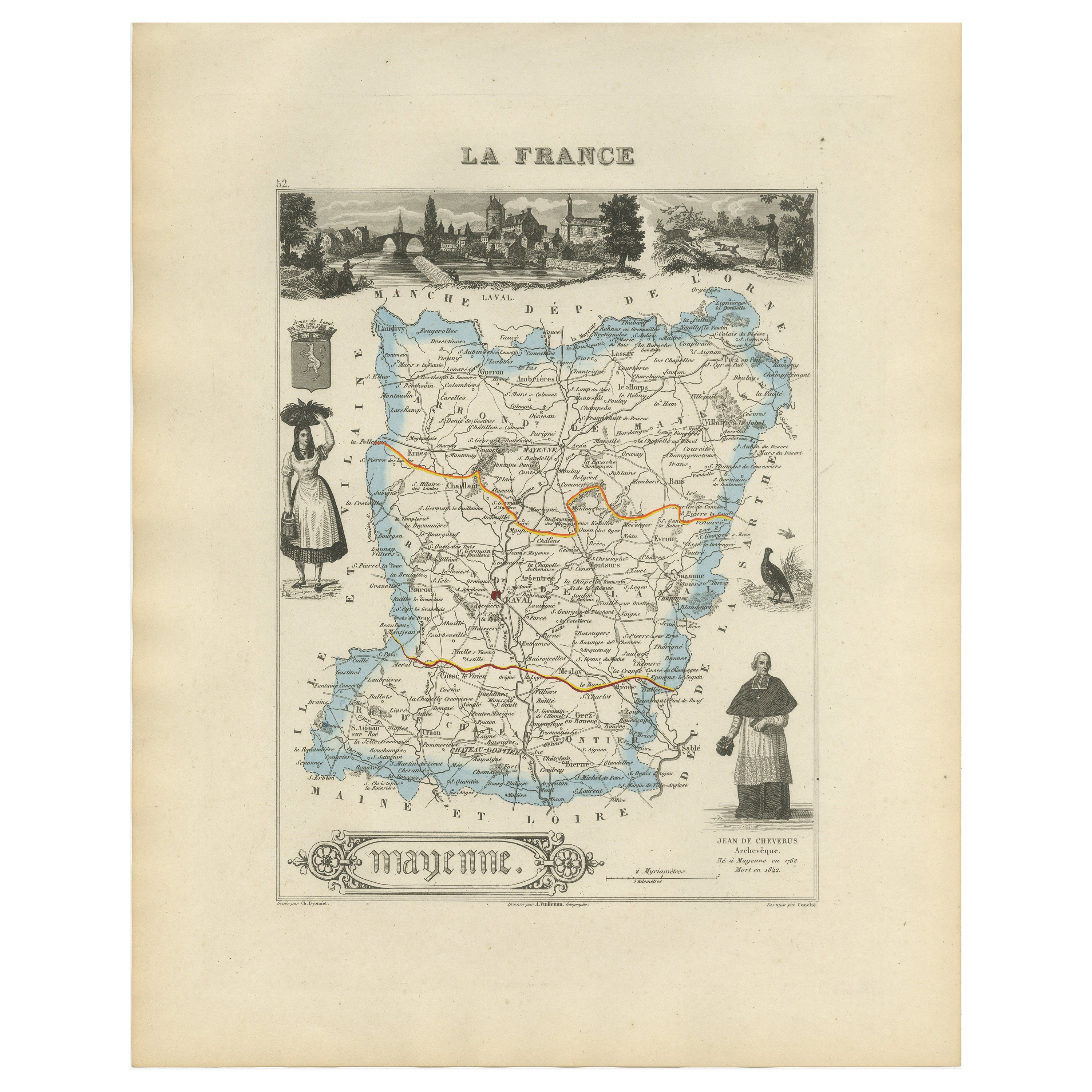
View AllAntique Map of Mayenne – Hand-Colored Engraving by Levasseur, France c.1850
Located in Langweer, NL
Antique Map of Mayenne – Hand-Colored Engraving by Levasseur, France c.1850
This finely detailed 19th-century engraved map of the department of Mayenne in northwestern France was cr...
Category
Antique Mid-19th Century French Maps
Materials
Paper
Antique Map of Marne, France – Engraved by Levasseur, 1850s
Located in Langweer, NL
Antique Map of Marne, France – Engraved by Levasseur, 1850s
This beautifully detailed 19th-century engraved map of the Marne department in northeastern France was created by the ren...
Category
Antique Mid-19th Century French Maps
Materials
Paper

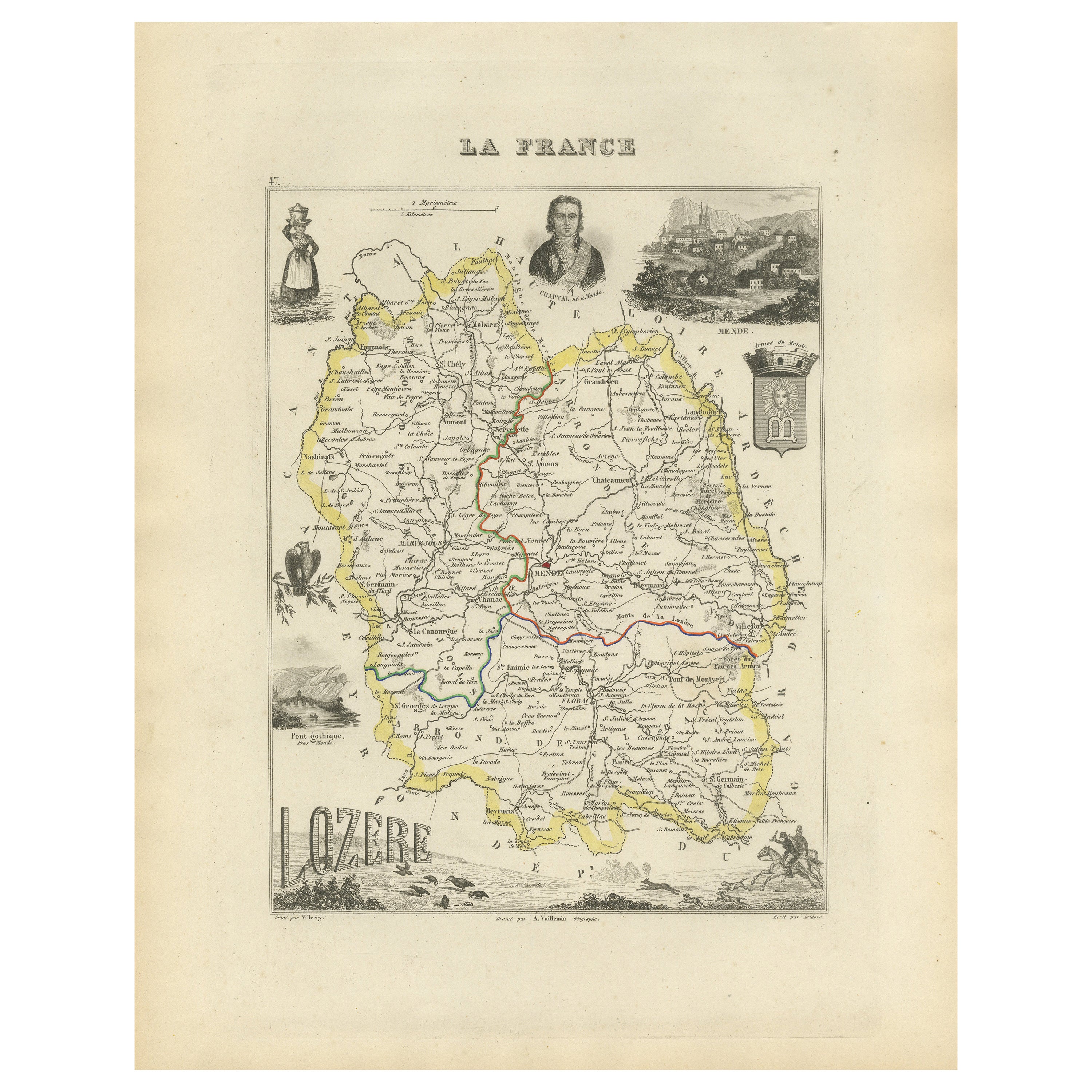
Antique Hand-Colored Map of Lozère, France – Alexandre Vuillemin, 19th Century
Located in Langweer, NL
Antique Map of Lozère, France – Vuillemin & Levasseur, Mid-19th Century
This finely detailed map of the department of Lozère in southern France was created by Alexandre Vuillemin an...
Category
Antique Mid-19th Century French Maps
Materials
Paper

Map of Côtes-du-Nord France with Saint-Brieuc and Brittany Coastline, c.1850
Located in Langweer, NL
Map of Côtes-du-Nord France with Saint-Brieuc and Brittany Coastline, 19th c
Description:
This elegant 19th-century map of Côtes-du-Nord, the historic name for what is now known as ...
Category
Antique Mid-19th Century French Maps
Materials
Paper

Map of Loire France with Saint-Étienne and Montbrison by Vuillemin, 19th c
Located in Langweer, NL
Map of Loire France with Saint-Étienne and Montbrison by Vuillemin, 19th c
This beautifully engraved and hand-colored map of the department of Loire in east-central France is from t...
Category
Antique Mid-19th Century French Maps
Materials
Paper

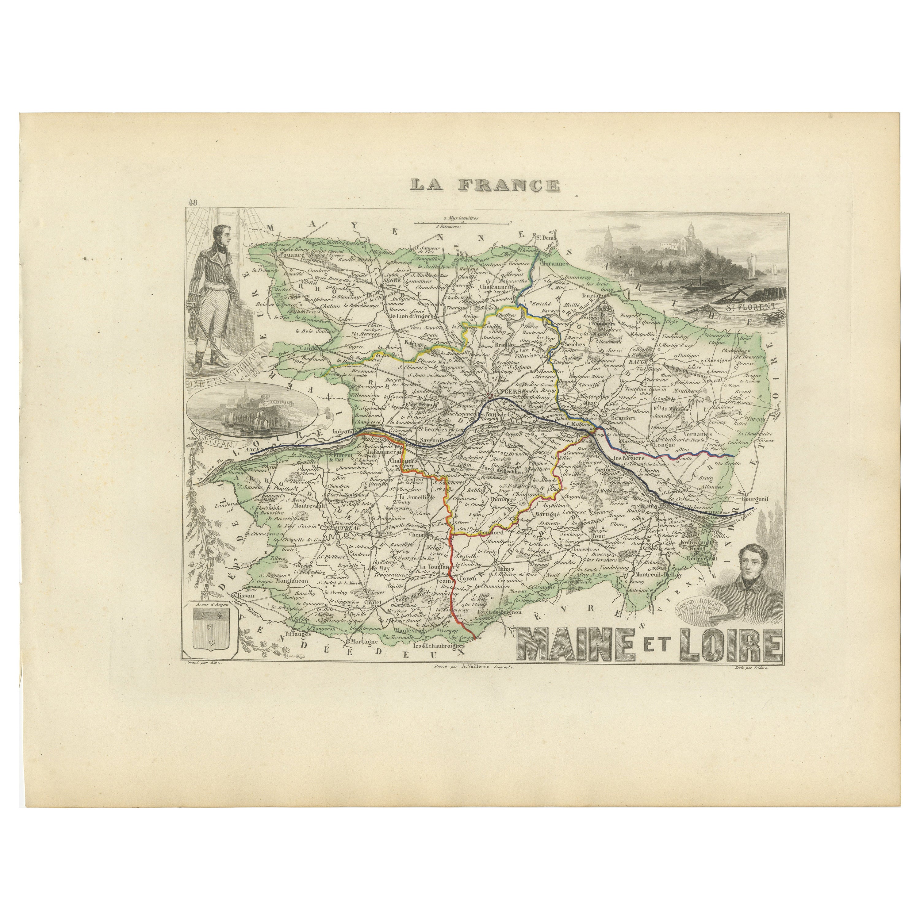
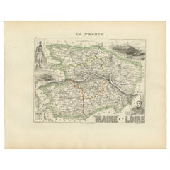
Antique Map of Maine-et-Loire with Illustrations – Vuillemin c.1850
Located in Langweer, NL
Antique Map of Maine-et-Loire with Illustrations – Vuillemin c.1850
A richly detailed 19th-century map of the Maine-et-Loire department in western France, engraved by A. Vuillemin a...
Category
Antique Mid-19th Century French Maps
Materials
Paper
You May Also Like
Saone and Loire, France. Antique map of a French department, 1856
By Victor Levasseur
Located in Melbourne, Victoria
'Dept. de Saone et Loire', steel engraving with original outline hand-colouring., 1856, from Levasseur's Atlas National Illustre.
The French department of Saone et Loire is at the ...
Category
19th Century Naturalistic Landscape Prints
Materials
Engraving

Lozere, France. Antique map of a French department, 1856
By Victor Levasseur
Located in Melbourne, Victoria
'Dept. de La Lozere', steel engraving with original outline hand-colouring., 1856, from Levasseur's 'Atlas National Illustre'.
This remote mountainous part of Languedoc is rural, s...
Category
19th Century Naturalistic Landscape Prints
Materials
Engraving

L
Isere, France. Antique map of French department, 1856
By Victor Levasseur
Located in Melbourne, Victoria
'Dept. de L'Isere', Steel engraving with original outline hand-colouring., 1856, from Levasseur's 'Atlas National Illustre'.
This area is known for its production of Bleu du Vercor...
Category
19th Century Naturalistic Landscape Prints
Materials
Engraving

Var, France. Antique map of a French department, 1856
By Victor Levasseur
Located in Melbourne, Victoria
'Dept. du Var', steel engraving with original outline hand-colouring., 1856, from Levasseur's Atlas National Illustre.
Var covers the heart of the French Riviera or Cote d'Azur., and includes the resort cities of Cannes, Nice and San Tropez...
Category
19th Century Naturalistic Landscape Prints
Materials
Engraving

Aude, France. Antique map of a French department, 1856
By Victor Levasseur
Located in Melbourne, Victoria
'Dept. de L' Aude', steel engraving with original outline hand-colouring., 1856, from Levasseur's 'Atlas National Illustre'.
This area of France is famous for its wide variety of v...
Category
19th Century Naturalistic Landscape Prints
Materials
Engraving

Aube, France. Antique map of a French department, 1856
By Victor Levasseur
Located in Melbourne, Victoria
'Dept. de L'Aube', steel engraving with original outline hand-colouring., 1856, from Levasseur's 'Atlas National Illustre'.
This area of France is known for its production of Chaou...
Category
19th Century Naturalistic Landscape Prints
Materials
Engraving
