Items Similar to Antique Map of Lot ‘France’ by V. Levasseur, 1854
Want more images or videos?
Request additional images or videos from the seller
1 of 5
Antique Map of Lot ‘France’ by V. Levasseur, 1854
$213.58
£159.45
€180
CA$296.73
A$319.17
CHF 170.58
MX$3,762.14
NOK 2,150.55
SEK 1,966.01
DKK 1,371.80
About the Item
Antique map titled 'Dépt. du Lot'. Map of the French department of Lot, France. This area of France is known for its production of Cahors wine, a powerful red wine, often “harsh when young, but remarkable after a few years in bottle.” The Pilgrimage to Santiago de Compostella also passes through the northern part of this region. This map originates from ‘Atlas National de la France Illustré’. Published by A. Combette, Paris, 1854.
- Dimensions:Height: 13.98 in (35.5 cm)Width: 20.67 in (52.5 cm)Depth: 0.02 in (0.5 mm)
- Materials and Techniques:
- Period:
- Date of Manufacture:1854
- Condition:General age-related toning. Please study image carefully.
- Seller Location:Langweer, NL
- Reference Number:Seller: BG-05614/801stDibs: LU3054310764911
About the Seller
5.0
Recognized Seller
These prestigious sellers are industry leaders and represent the highest echelon for item quality and design.
Platinum Seller
Premium sellers with a 4.7+ rating and 24-hour response times
Established in 2009
1stDibs seller since 2017
2,838 sales on 1stDibs
Typical response time: 1 hour
- ShippingRetrieving quote...Shipping from: Langweer, Netherlands
- Return Policy
More From This Seller
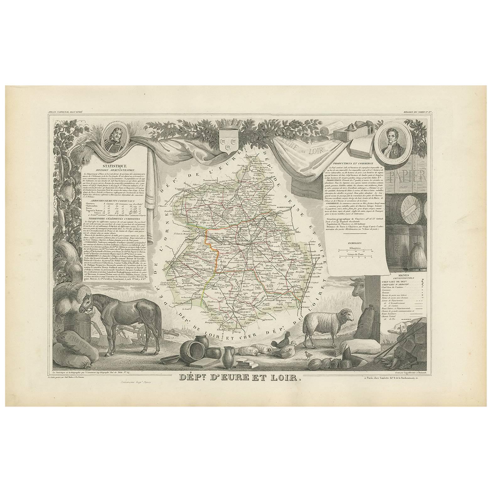
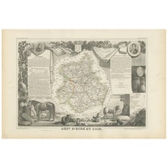
View AllAntique Map of Eure Et Loir ‘France’ by v. Levasseur, 1854
By Victor Levasseur
Located in Langweer, NL
Antique map titled 'Dépt. d'Eure et Loir'. Map of the French department of Eure Et Loir, France. This area is home to the famous Chartres Cathedral....
Category
Antique Mid-19th Century Maps
Materials
Paper
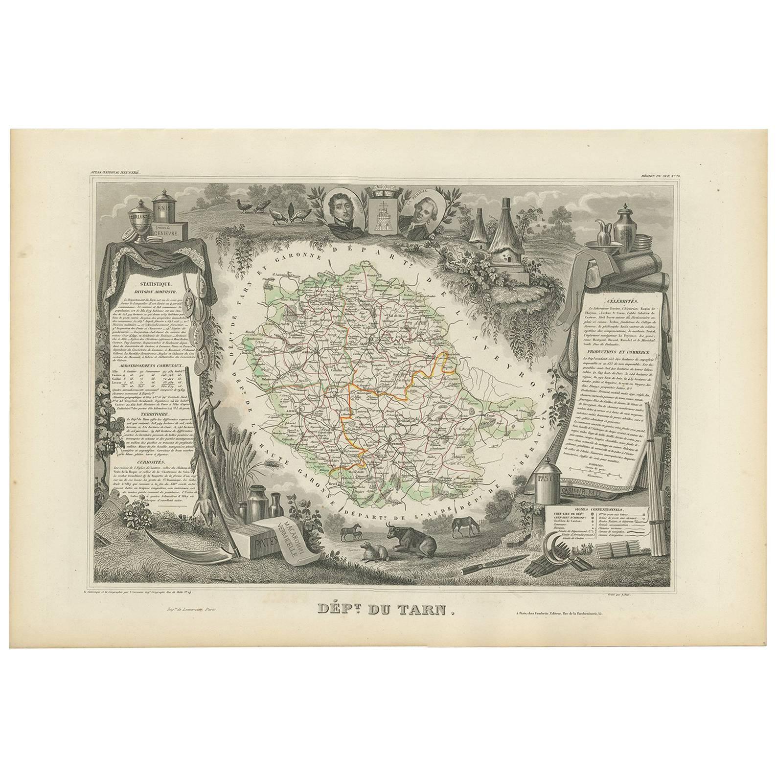
Antique Map of Tarn
France
by V. Levasseur, 1854
By Victor Levasseur
Located in Langweer, NL
Antique map titled 'Dépt. du Tarn'. Map of the French department of Tarn, France. This area produces a variety of traditional wines, including Cahors, Mauzac, Loin de l'Oeil and Onde...
Category
Antique Mid-19th Century Maps
Materials
Paper

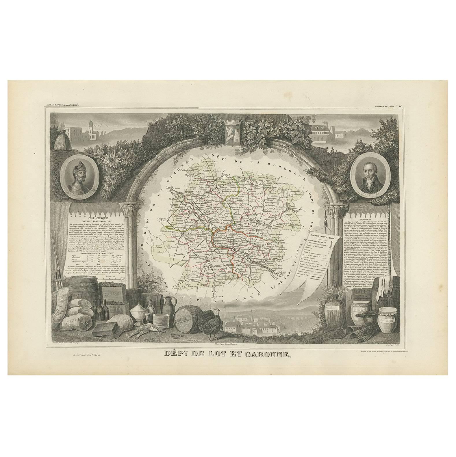
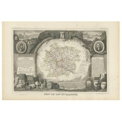
Antique Map of Lot et Garonne ‘France’ by V. Levasseur, 1854
Located in Langweer, NL
Antique map titled 'Dépt. de Lot et Garonne'. Map of the French department of Lot et Garonne, France. This area of France is known for its production of Buzet wines and Cabécou d’Ant...
Category
Antique Mid-19th Century Maps
Materials
Paper
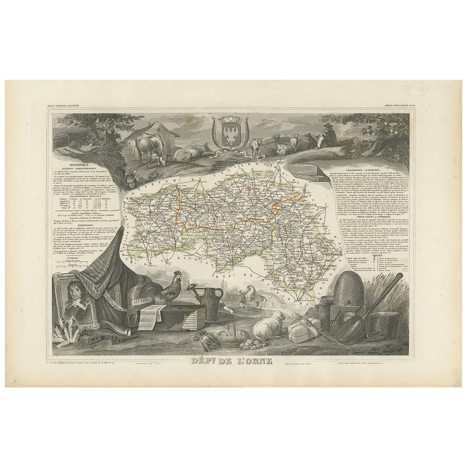
Antique Map of Orne ‘France’ by V. Levasseur, 1854
By Victor Levasseur
Located in Langweer, NL
Antique map titled 'Dépt. de l'Orne'. Map of the French department of Orne, France. This area, part of Normandy, includes the village of Camembert, where the famous Camembert cheese ...
Category
Antique Mid-19th Century Maps
Materials
Paper

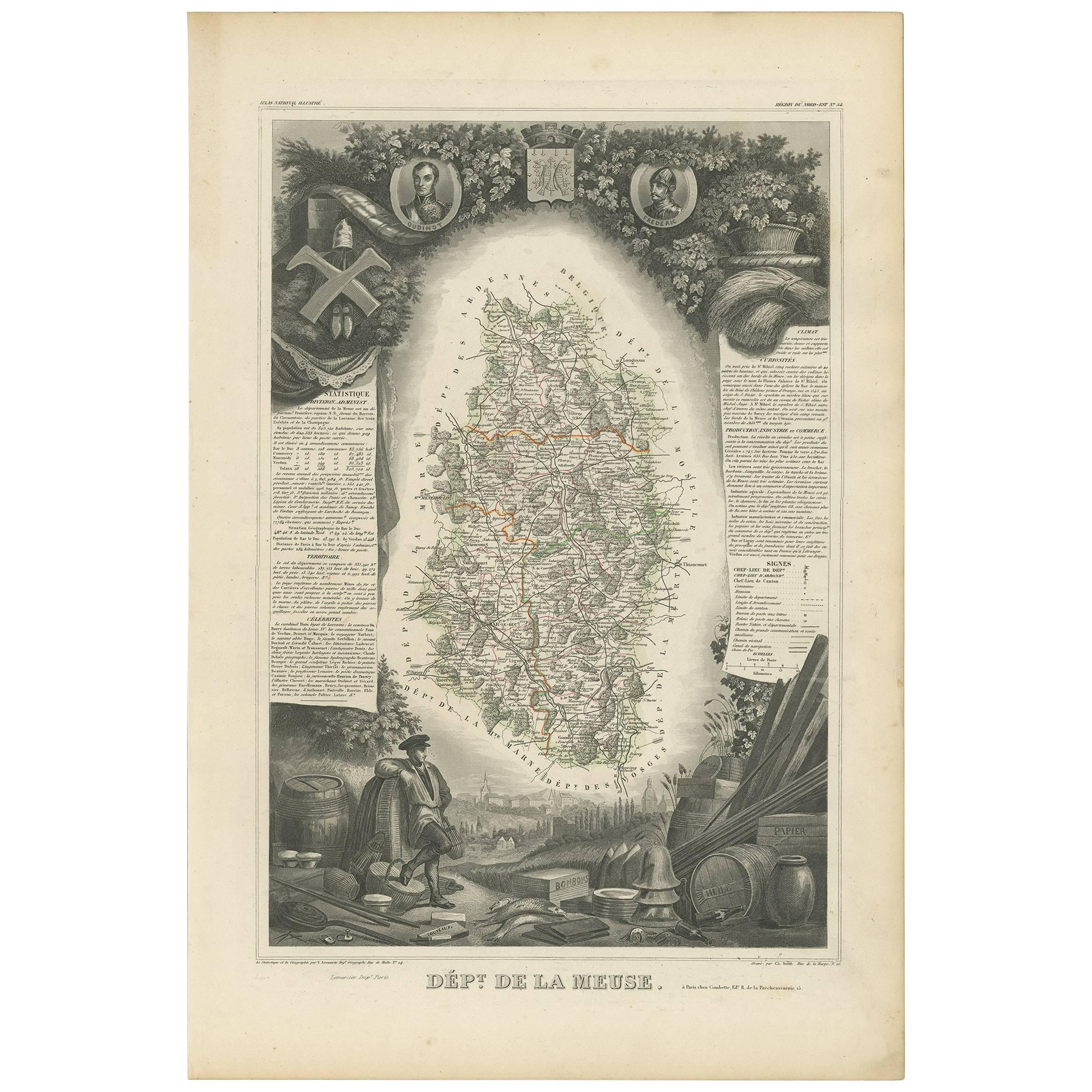
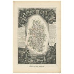
Antique Map of Meuse ‘France’ by V. Levasseur, 1854
Located in Langweer, NL
Antique map titled 'Dépt. de la Meuse'. Map of the French department of Meuse, France. This area part of the Lorraine or Alsace-Lorraine wine regions. It is also known for its produc...
Category
Antique Mid-19th Century Maps
Materials
Paper
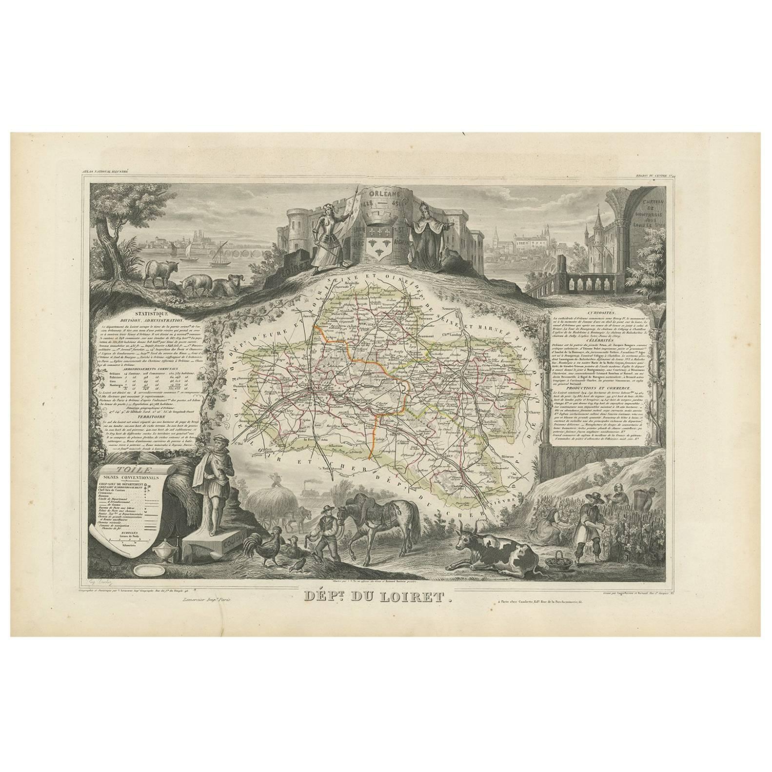
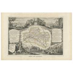
Antique Map of Loiret ‘France’ by V. Levasseur, 1854
Located in Langweer, NL
Antique map titled 'Dépt. du Loiret'. Map of the French department of Loiret, France. Surrounding the city of Orleans, Loiret is considered the heart of France and is a registered Unesco World Heritage Site. This area of France is also part of the Loire Valley wine region, and is especially known for its production of Pinot Noirs...
Category
Antique Mid-19th Century Maps
Materials
Paper
You May Also Like
Jura, France. Antique map of a French department, 1856
By Victor Levasseur
Located in Melbourne, Victoria
'Dept. du Jura', steel engraving with original outline hand-colouring., 1856, from Levasseur's 'Atlas National Illustre'.
The Jura wines are very distinctive and unusual, such as V...
Category
19th Century Naturalistic Landscape Prints
Materials
Engraving

Lozere, France. Antique map of a French department, 1856
By Victor Levasseur
Located in Melbourne, Victoria
'Dept. de La Lozere', steel engraving with original outline hand-colouring., 1856, from Levasseur's 'Atlas National Illustre'.
This remote mountainous part of Languedoc is rural, s...
Category
19th Century Naturalistic Landscape Prints
Materials
Engraving

Saone and Loire, France. Antique map of a French department, 1856
By Victor Levasseur
Located in Melbourne, Victoria
'Dept. de Saone et Loire', steel engraving with original outline hand-colouring., 1856, from Levasseur's Atlas National Illustre.
The French department of Saone et Loire is at the ...
Category
19th Century Naturalistic Landscape Prints
Materials
Engraving

Var, France. Antique map of a French department, 1856
By Victor Levasseur
Located in Melbourne, Victoria
'Dept. du Var', steel engraving with original outline hand-colouring., 1856, from Levasseur's Atlas National Illustre.
Var covers the heart of the French Riviera or Cote d'Azur., and includes the resort cities of Cannes, Nice and San Tropez...
Category
19th Century Naturalistic Landscape Prints
Materials
Engraving

Indre and Loire, France. Antique map of a French department, 1856
By Victor Levasseur
Located in Melbourne, Victoria
'Dept. d'Indre et Loire', steel engraving with original outline hand-colouring., 1856, from Levasseur's 'Atlas National Illustre'.
This area is known for its production of Chenin b...
Category
19th Century Naturalistic Landscape Prints
Materials
Engraving

L
Isere, France. Antique map of French department, 1856
By Victor Levasseur
Located in Melbourne, Victoria
'Dept. de L'Isere', Steel engraving with original outline hand-colouring., 1856, from Levasseur's 'Atlas National Illustre'.
This area is known for its production of Bleu du Vercor...
Category
19th Century Naturalistic Landscape Prints
Materials
Engraving

More Ways To Browse
Antique Maps Of Holland
Compass Rose Antique
Antique Furniture Portugal
Antique Maps Of Europe
Mexican Antiques
Map Of Africa
Mississippi Antique
Antique Furniture Plans
Ancient Collectibles
Antique Wood Coat Of Arms
Antique Quadrant
Antique Maps Of Africa
Antique Map India
Antique Map Of The South Of France
Antique English Maps
Indonesia Map
Ancient Maps
Antique Mining