Items Similar to Antique Map of Madagascar by N. Sanson, circa 1680


Want more images or videos?
Request additional images or videos from the seller
1 of 5
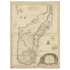
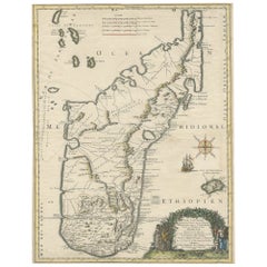
Antique Map of Madagascar by N. Sanson, circa 1680
$299.02
£222.04
€250
CA$410.80
A$446.62
CHF 236.80
MX$5,353.89
NOK 3,009.62
SEK 2,757.22
DKK 1,905.80
About the Item
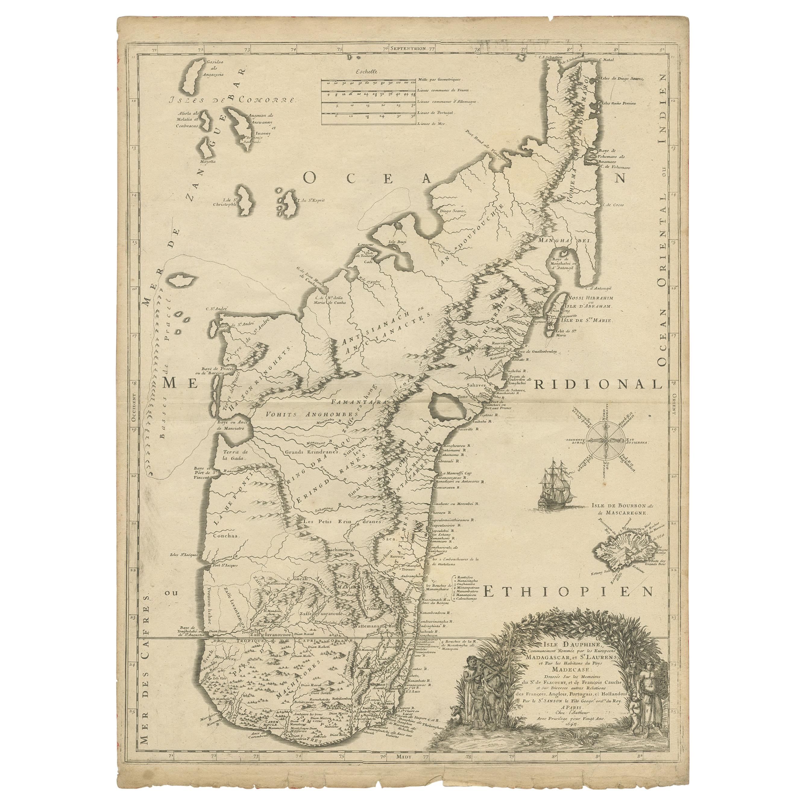
Antique map titled 'Isle de Madagascar ou de St. Laurens. Tiree de Sanutu &c'. Antique map of Madagascar, first published by Sanson in 1657. Sanson notes the source of his map as Livio Sanuto and others. Livio Sanuto was a mid-16th century Italian cosmographer and mathematician who contributed and was one of the primary map makers of his time.
Sanuto created the first Atlas of Africa ( Geografia dell 'Africa) published in 1588 in Venice, which was without question the most accurate work of its time and formed the basis for the mapping of Africa for the next century.
- Creator:Nicolas Sanson (Artist)
- Dimensions:Height: 9.65 in (24.5 cm)Width: 14.57 in (37 cm)Depth: 0.02 in (0.5 mm)
- Materials and Techniques:
- Period:Late 17th Century
- Date of Manufacture:circa 1680
- Condition:General age-related toning. Minor wear and foxing, blank verso. Please study images carefully.
- Seller Location:Langweer, NL
- Reference Number:Seller: BG-12416-31stDibs: LU3054318531232
About the Seller
5.0
Recognized Seller
These prestigious sellers are industry leaders and represent the highest echelon for item quality and design.
Platinum Seller
Premium sellers with a 4.7+ rating and 24-hour response times
Established in 2009
1stDibs seller since 2017
2,821 sales on 1stDibs
Typical response time: 1 hour
- ShippingRetrieving quote...Shipping from: Langweer, Netherlands
- Return Policy
More From This Seller
View AllAntique Map of Madagascar by Mariette
c.1670
Located in Langweer, NL
Antique map titled 'Isle Dauphine communement nommée par les Europeens Madagascar, et St. Laurens (..)'. Original large-scale antique map of Madagascar...
Category
Antique Mid-17th Century Maps
Materials
Paper
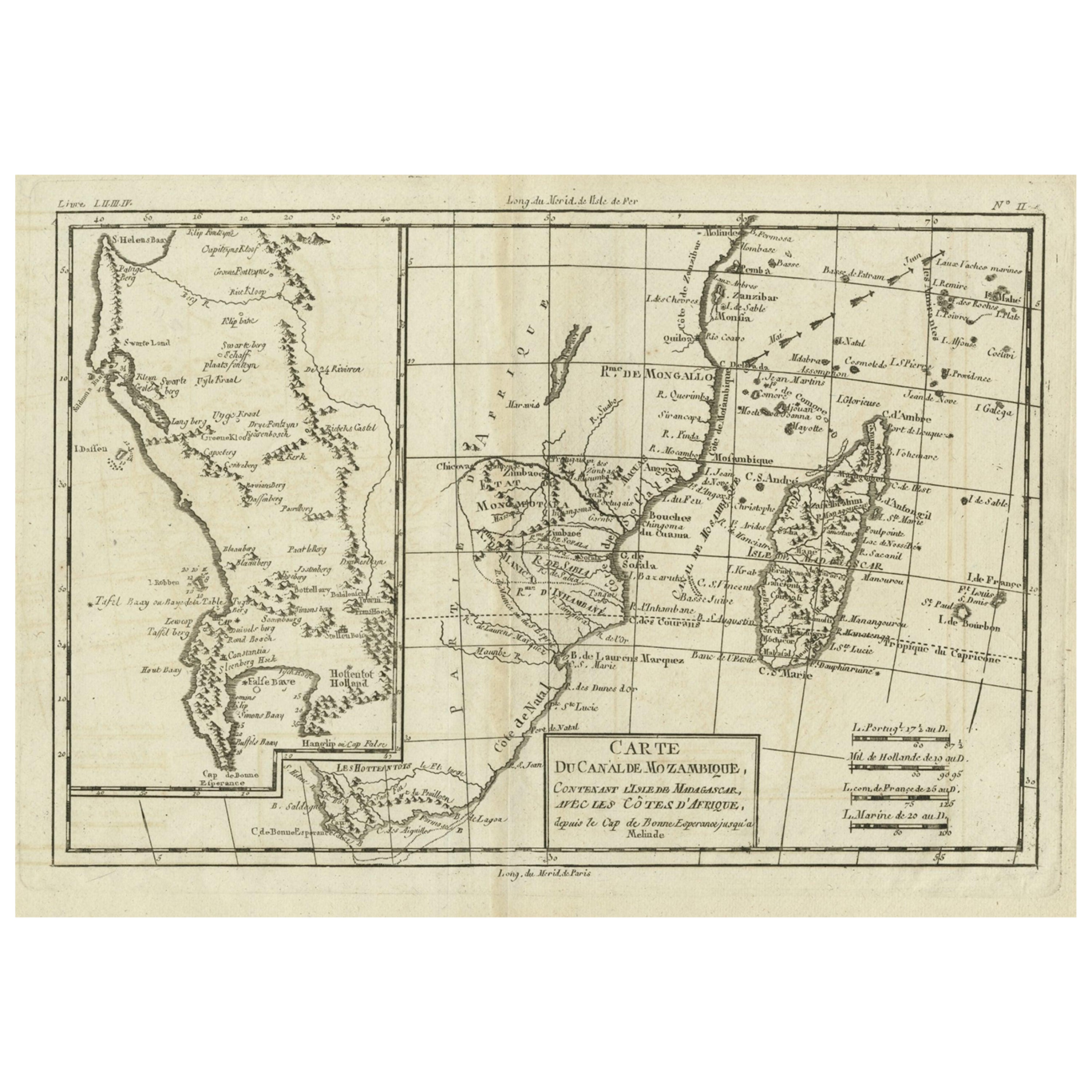
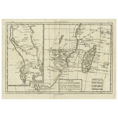
Antique Map of Mozambique Channel with Madagascar and Inset of Cape Region, 1780
Located in Langweer, NL
Antique map titled 'Carte du canal de Mosambique, contenant l'Isle de Madagascar avec les Cotes d'Afrique.' Map of Mozambique Channel, containing the Island of Madagascar with the coasts of Africa from Cape of Good Hope to Melinde. The inset map shows the Cape region in South Africa with False Bay, Robben Island etc. Source unknown, to be determined. Artists and Engravers: Rigobert Bonne (1727-1795 ) was one of the most important cartographers of the late 18th century. In 1773 he succeeded Jacques Bellin as Royal Cartographer to France in the office of the Hydrographer at the Depôt de la Marine. Working in his official capacity Bonne compiled some of the most detailed and accurate maps of the period. Bonne's work represents an important step in the evolution of the cartographic ideology away from the decorative work of the 17th and early 18th century towards a more detail oriented and practical aesthetic. With regard to the rendering of terrain Bonne maps...
Category
Antique 18th Century Maps
Materials
Paper
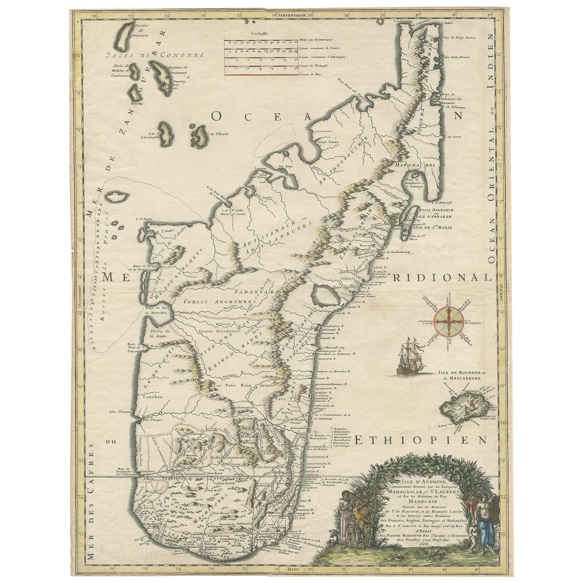
Beautiful Antique Map of Madagascar, The Comoros Islands
Reunion Island, 1667
Located in Langweer, NL
Antique map titled 'Isle d'Auphine, communement Nommée par les Europeens Madagascar, et St. Laurens, et par les Habitans du pays Madecase'.
Beautiful map of Madagascar...
Category
Antique 1660s Maps
Materials
Paper
$870 Sale Price
20% Off
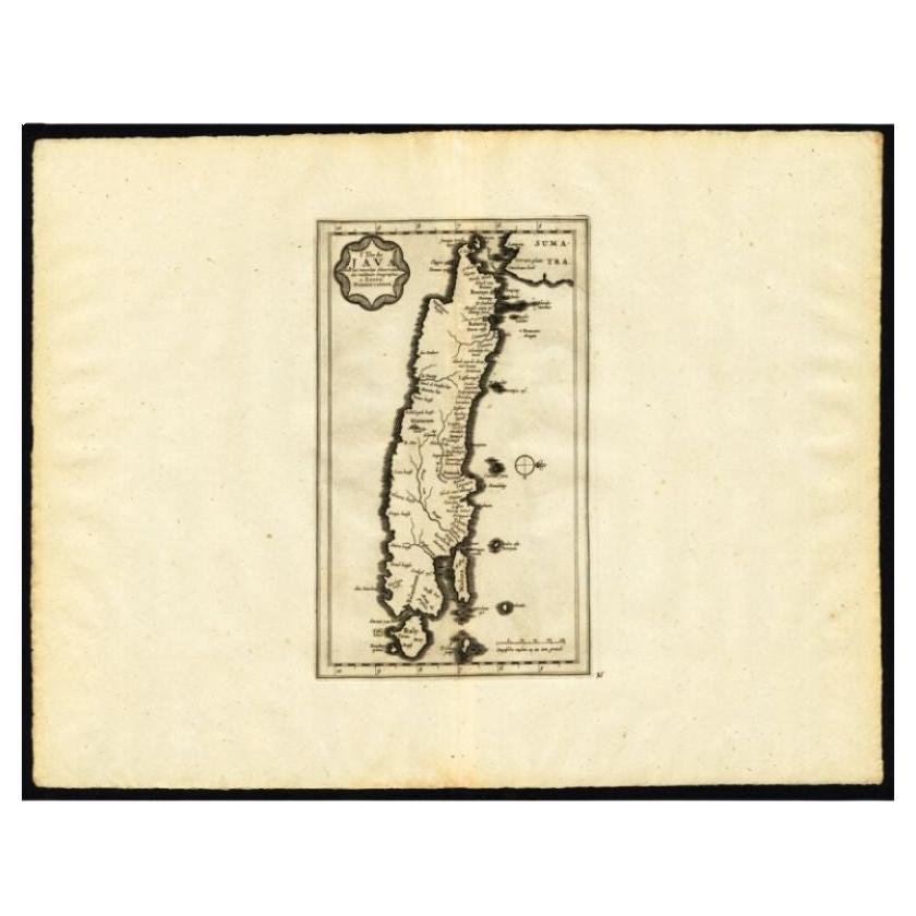
Antique Map of the Island of Java by Van Der Aa, 1725
By Pieter Van Der Aa
Located in Langweer, NL
Antique map titled 'Map: 'L'Ile de Java'. (The island of Java.) This map shows the Indonesian island of Java. With compass rose and scale. This plate originates from the very scarse:...
Category
Antique 18th Century Maps
Materials
Paper
Rare Antique Map of
Barbarie
or Northern Africa, 1655
Located in Langweer, NL
Antique map titled 'Partie de la Coste de Barbarie en Africque ou sont les Royaumes de Tunis et Tripoli et Pays Circomvoisins'. This map depicts North Africa with Malta and originate...
Category
Antique 17th Century Maps
Materials
Paper

Antique Map of the Island of Java, Indonesia by P. Van Der Aa, 1713
Located in Langweer, NL
This rare map shows the Indonesian island of Java. With compass rose and scale. From: Nouvel Atlas, très exact et fort commode pour toutes sortes de personnes, Contenant Les Principa...
Category
Antique Early 18th Century Maps
Materials
Paper

You May Also Like
1627 Hendrik Hondius Map Entitled "Vltoniae Orientalis Pars, " Ric.a009
Located in Norton, MA
1627 Hendrik Hondius map entitled
"Vltoniae orientalis pars,"
Ric.a009
Title:
Vltoniae orientalis : pars
Title (alt.) :
Ultoniae orientalis pars
Creator:
Mercator, Gerh...
Category
Antique 17th Century Dutch Maps
Materials
Paper

1646 Jansson Map Entitled "Procinvia Connactiae, " Ric.a006
Located in Norton, MA
1646 Jansson map entitled
"Procinvia connactiae,"
Ric.a006
Description: The PROVINCE of CONNAVGT 490 x 380From vol 4 of Jansson's Atlas Novus 1646, published in Amsterdam with...
Category
Antique 17th Century Unknown Maps
Materials
Paper

Sweden
Adjacent Portions of Scandinavia: A Hand-Colored 18th C. Map by Homann
By Johann Baptist Homann
Located in Alamo, CA
This hand-colored map of Sweden and adjacent portions of Scandinavia entitled "Regni Sueciae in Omnes suas Subjacentes Provincias accurate divisi Tabula Generalis" was created by Joh...
Category
Antique 1720s German Maps
Materials
Paper

$780 Sale Price
20% Off
Southern Greece: A Large 17th C. Hand-colored Map by Sanson and Jaillot
By Nicolas Sanson
Located in Alamo, CA
This large original hand-colored copperplate engraved map of southern Greece and the Pelopponese Peninsula entitled "La Moree Et Les Isles De Zante, Cefalonie, Ste. Marie, Cerigo & C...
Category
Antique 1690s French Maps
Materials
Paper

$1,580 Sale Price
20% Off
Africa: A Large 17th Century Hand-Colored Map by Sanson and Jaillot
By Nicolas Sanson
Located in Alamo, CA
This large original hand-colored copperplate engraved map of Africa entitled "L'Afrique divisee suivant l'estendue de ses principales parties ou sont distingues les uns des autres, L...
Category
Antique 1690s French Maps
Materials
Paper

$1,740 Sale Price
20% Off
West Coast of Africa, Guinea
Sierra Leone: An 18th Century Map by Bellin
By Jacques-Nicolas Bellin
Located in Alamo, CA
Jacques Bellin's copper-plate map entitled "Partie de la Coste de Guinee Dupuis la Riviere de Sierra Leona Jusquau Cap das Palmas", depicting the coast of Guinea and Sierra Leone in ...
Category
Antique Mid-18th Century French Maps
Materials
Paper

$460 Sale Price
20% Off
More Ways To Browse
Map Of Madagascar
Blaeu Maps
Antique Topographic Maps
Antique Maps Of North America
Antique Maps Of Italy
Antique Navigator
Antique Maps Of Britain
Wood Furniture Bali
Scotland Map
Antique Maps Scotland
Furniture Russian 18th Century
Antique Map Of Middle East
London Antique Maps
Map Colorful
Maps Of Australia
Antique Railroad Furniture
Map Of London
Antique Galleon