Items Similar to Antique Map of the Maluku Islands or Moluccas, Indonesia

Want more images or videos?
Request additional images or videos from the seller
1 of 6
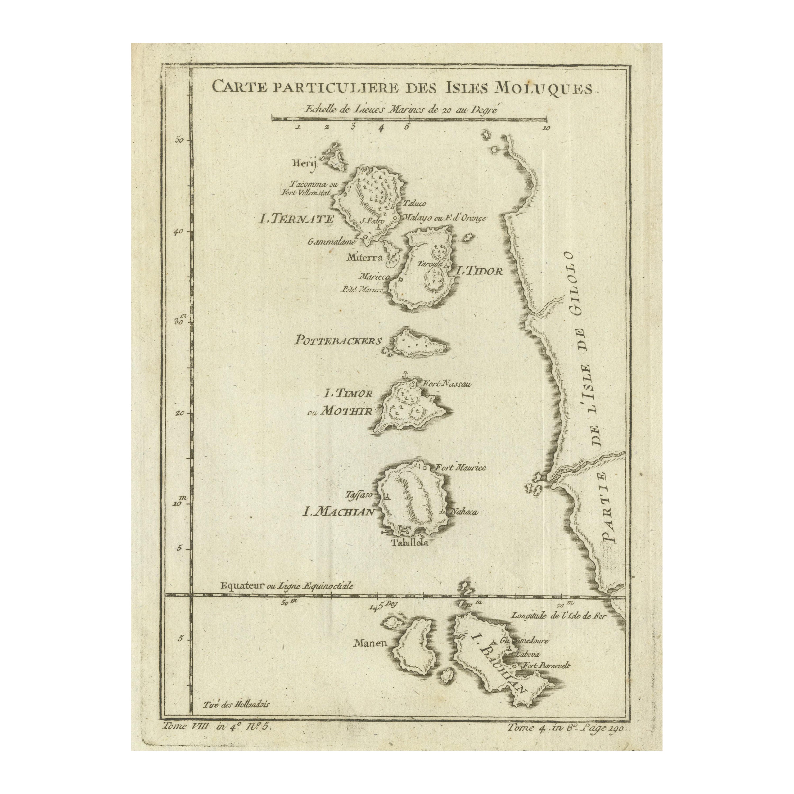
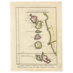
Antique Map of the Maluku Islands or Moluccas, Indonesia
$143.53
$179.4120% Off
£106.58
£133.2220% Off
€120
€15020% Off
CA$197.18
CA$246.4820% Off
A$214.38
A$267.9720% Off
CHF 113.66
CHF 142.0820% Off
MX$2,569.87
MX$3,212.3420% Off
NOK 1,444.62
NOK 1,805.7720% Off
SEK 1,323.46
SEK 1,654.3320% Off
DKK 914.78
DKK 1,143.4820% Off
About the Item
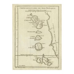
Antique map titled 'Carte Particuliere des Isles Moluques'. This map depicts the islands of Herij, Ternate, Tidor, Pottebackers, Timor, Machian and Bachian. The Moluccan islands were once part of the Dutch East Indies. Today the Moluccas are part of Indonesia. This map originates from Prevost’s ‘Histoire Generale des Voyages (..)’ Engraved by J.N. Bellin.
Jacques-Nicolas Bellin (1703 - 1772) was one of the most important cartographers of the 18th century. With a career spanning some 50 years, Bellin is best understood as geographe de cabinet and transitional mapmaker spanning the gap between 18th and early 19th century cartographic styles. His long career as Hydrographer and Ingénieur Hydrographe at the French Dépôt des cartes et plans de la Marine resulted in hundreds of high quality nautical charts of practically everywhere in the world. A true child of the Enlightenment Era, Bellin's work focuses on function and accuracy tending in the process to be less decorative than the earlier 17th and 18th century cartographic work. Unlike many of his contemporaries, Bellin was always careful to cite his references and his scholarly corpus consists of over 1400 articles on geography prepared for Diderot's Encyclopedie. Bellin, despite his extraordinary success, may not have enjoyed his work, which is described as "long, unpleasant, and hard." In addition to numerous maps and charts published during his lifetime, many of Bellin's maps were updated (or not) and published posthumously. He was succeeded as Ingénieur Hydrographe by his student, also a prolific and influential cartographer, Rigobert Bonne.
- Dimensions:Height: 10.08 in (25.6 cm)Width: 7.17 in (18.2 cm)Depth: 0.02 in (0.5 mm)
- Materials and Techniques:
- Period:
- Date of Manufacture:circa 1760
- Condition:Replacements made: Left margin extended. General age-related toning. Left margin extended. Shows wear and soiling. Blank verso. Please study image carefully.
- Seller Location:Langweer, NL
- Reference Number:Seller: BG-12707-681stDibs: LU3054334606012
About the Seller
5.0
Recognized Seller
These prestigious sellers are industry leaders and represent the highest echelon for item quality and design.
Platinum Seller
Premium sellers with a 4.7+ rating and 24-hour response times
Established in 2009
1stDibs seller since 2017
2,821 sales on 1stDibs
Typical response time: 1 hour
- ShippingRetrieving quote...Shipping from: Langweer, Netherlands
- Return Policy
More From This Seller
View AllOriginal Antique Map of the Maluku Islands or Moluccas, Indonesia
Located in Langweer, NL
Antique map titled 'Carte Particuliere des Isles Moluques'. This map depicts the islands of Herij, Ternate, Tidor, Pottebackers, Timor, Machian and Bachian. The Moluccan islands were...
Category
Antique Mid-18th Century Maps
Materials
Paper
$105 Sale Price
20% Off
Original Antique Map of the Maluku Islands or Moluccas
Located in Langweer, NL
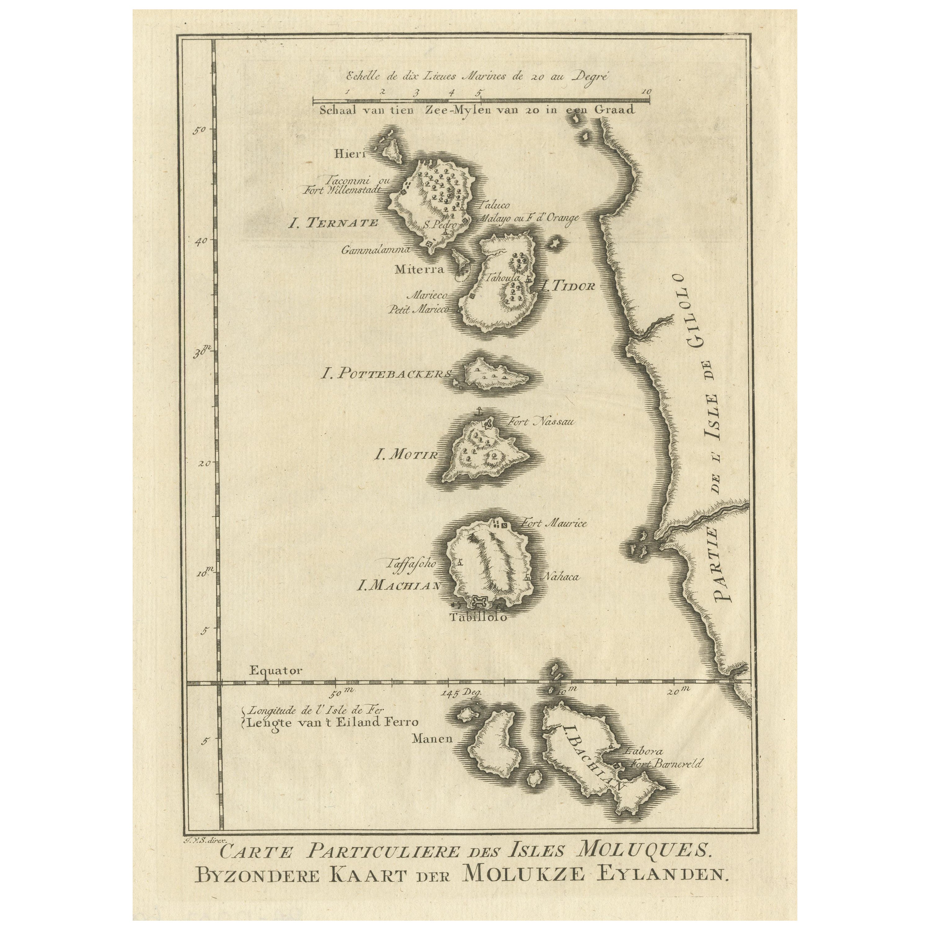
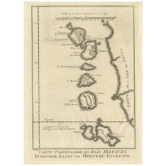
Antique map titled 'Carte Particuliere des Isles Moluques - Byzondere Kaart der Molukze Eylanden'. This map depicts the islands of Herij, Ternate, Tidor, Pottebackers, Timor, Machian...
Category
Antique Mid-18th Century Maps
Materials
Paper
$181 Sale Price
20% Off
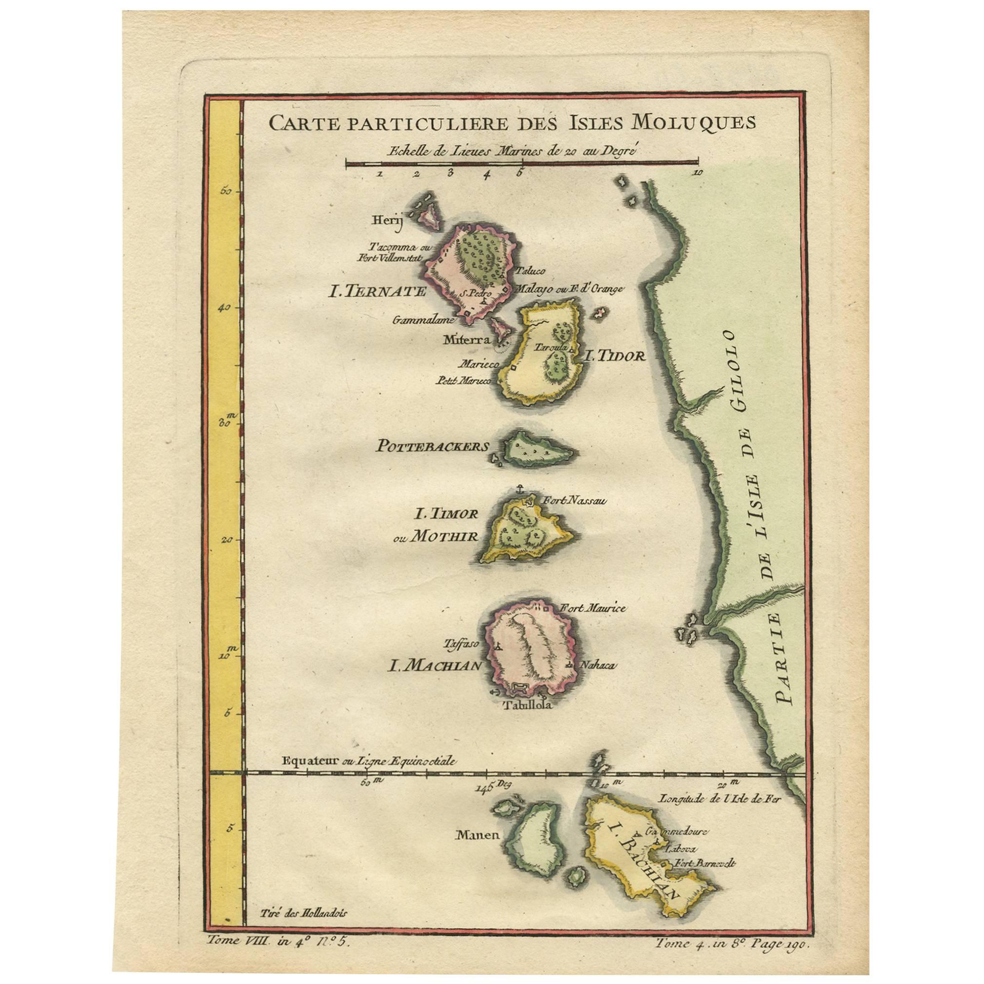
Antique Map of the Moluques Islands, Part of Indonesia, circa 1750
Located in Langweer, NL
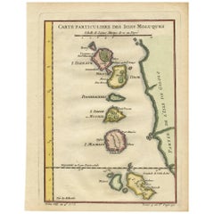
Map of the Moluques (also known as the Moluccas, Moluccan Islands or simply Maluku). Depicts the islands of Herij, Ternate, Tidor, Pottebackers, Timor, Machian and Bachian.
Category
Antique Mid-18th Century Maps
Materials
Paper
Old Map of the Spice Islands, Moluccas by Bellin, Published in 1771
Located in Langweer, NL
Title: 1771 Jacques-Nicolas Bellin Map of the Moluccas, the Spice Islands of Indonesia
Description: This finely engraved eighteenth-century map, titled Carte Particulière des Is...
Category
Antique 1770s Maps
Materials
Paper
$191 Sale Price
20% Off
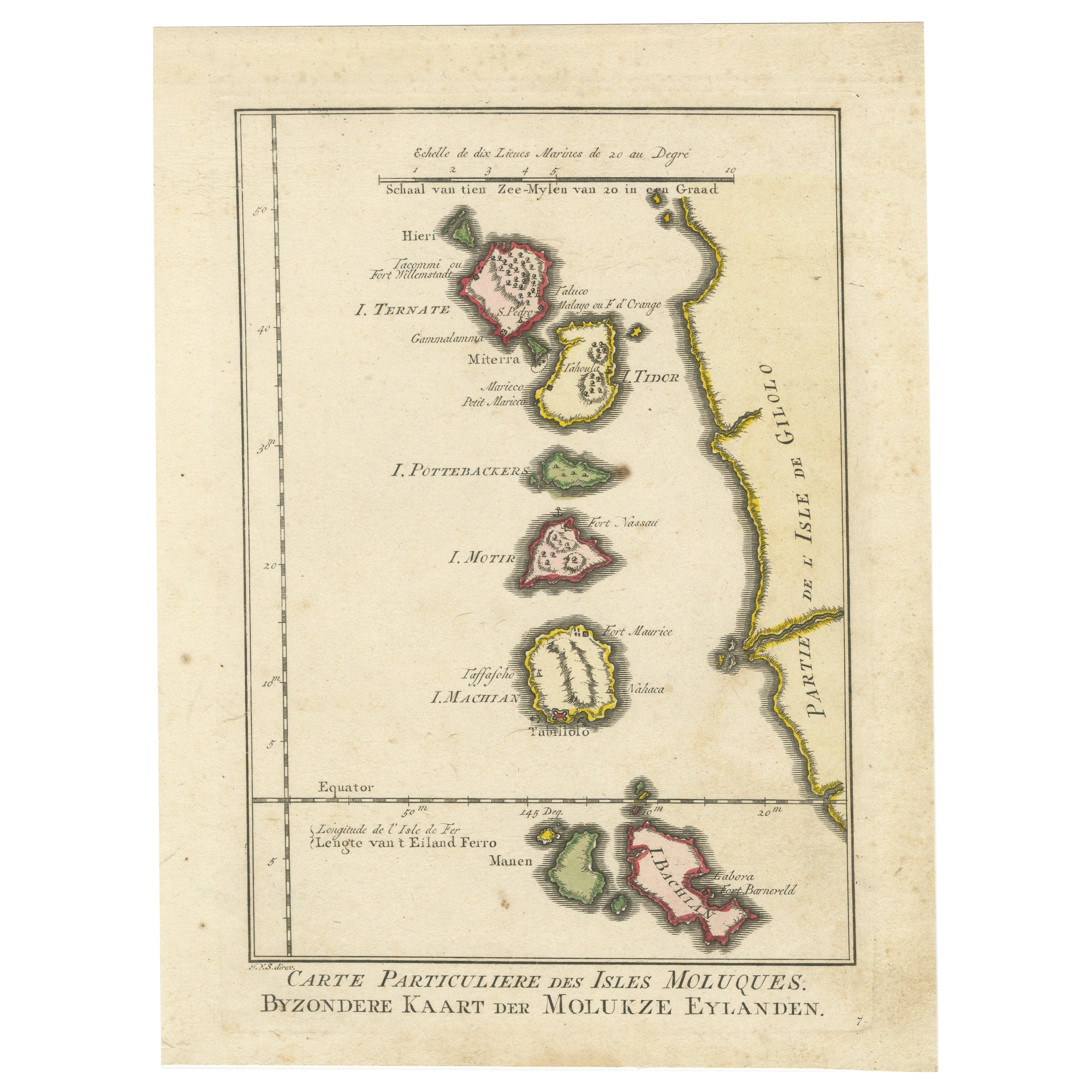
Antique Map of the Maluku Islands by Bellin, c.1750
By Jacques-Nicolas Bellin
Located in Langweer, NL
Antique map titled 'Carte Particuliere des Isles Moluques'. This map depicts the islands of Herij, Ternate, Tidor, Pottebackers, Timor, Machian and Bachian. The Moluccan islands were...
Category
Antique 18th Century Maps
Materials
Paper

Old Map of the Moluccas, Known as the Famous Spice Islands, Indonesia, ca.1730
Located in Langweer, NL
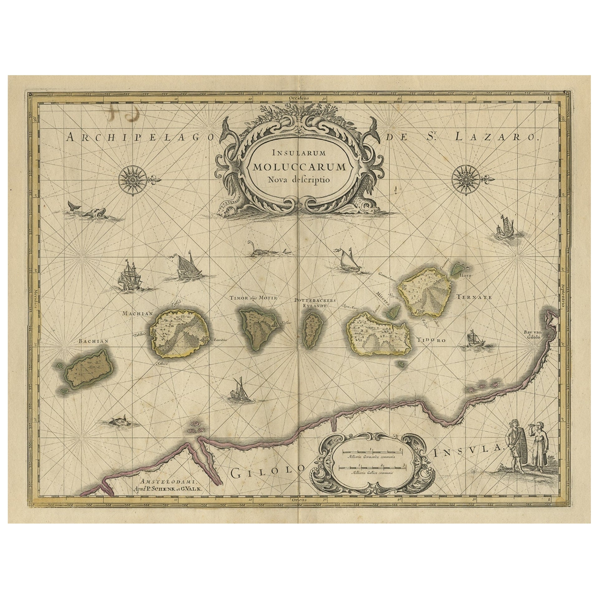
Antique map titled 'Insularum Moluccarum Nova Descriptio.'
Old map of the Moluccas. The famous Spice Islands, the cornerstone of the Dutch trading empire in the East Indies throughout the 17th Century, is the focus of this exquisite map. Similar to Blaeu's map, except that it extends further south...
Category
Antique 1730s Maps
Materials
Paper

$660 Sale Price
20% Off
You May Also Like
Antique French Map of Asia Including China Indoneseia India, 1783
Located in Amsterdam, Noord Holland
Very nice map of Asia. 1783 Dedie au Roy.
Additional information:
Country of Manufacturing: Europe
Period: 18th century Qing (1661 - 1912)
Condition: Overall Condition B (Good Used)...
Category
Antique 18th Century European Maps
Materials
Paper

$486 Sale Price
40% Off
Captain Cook
s Exploration of Tahiti 18th C. Hand-Colored Map by Bellin
By Jacques-Nicolas Bellin
Located in Alamo, CA
This beautiful 18th century hand-colored copper plate engraved map is entitled "Carte de l'Isle de Taiti, par le Lieutenant J. Cook" was created by Jacques Nicolas Bellin and publish...
Category
Antique Mid-18th Century French Maps
Materials
Paper

$620 Sale Price
20% Off
Large Original Vintage Map of The Pacific Islands Including Hawaii
Located in St Annes, Lancashire
Great map of The Pacific Islands
Unframed
Original color
By John Bartholomew and Co. Edinburgh Geographical Institute
Published, circa 1...
Category
Vintage 1920s British Maps
Materials
Paper

Original Antique Map of US Possessions In The Pacific Ocean, C.1900
Located in St Annes, Lancashire
Fabulous map of US possessions in the Pacific Ocean
Original color.
Engraved and printed by the George F. Cram Company, Indianapolis.
Published, C.1900.
Unframed.
Free shipping.
Category
Antique 1890s American Maps
Materials
Paper

Original Antique Map of South East Asia by Thomas Clerk, 1817
Located in St Annes, Lancashire
Great map of South East Asia
Copper-plate engraving
Drawn and engraved by Thomas Clerk, Edinburgh.
Published by Mackenzie And Dent, 1817
Unframed.
Category
Antique 1810s English Maps
Materials
Paper

West Coast of Africa, Guinea
Sierra Leone: An 18th Century Map by Bellin
By Jacques-Nicolas Bellin
Located in Alamo, CA
Jacques Bellin's copper-plate map entitled "Partie de la Coste de Guinee Dupuis la Riviere de Sierra Leona Jusquau Cap das Palmas", depicting the coast of Guinea and Sierra Leone in ...
Category
Antique Mid-18th Century French Maps
Materials
Paper

$460 Sale Price
20% Off
More Ways To Browse
Indonesian Antiques
Vintage Long Island Map
Vintage World Map Desk
Vintage World Map Mirror
Antique Furniture Toledo Ohio
Antique Maps Washington Dc
Blaeu World Map
Cape Cod Map
F Colton
Irish Antiques 16th Century
Ithaca Antique Map
Leonard Jones
Russia Globe
Salt Lake City Used Furniture
World Map Copper
Luxury Modern Carpet
French Directoire Furniture
French Earthenware