Items Similar to Antique Map of the Middle East with a Large Arabia, 1799


Want more images or videos?
Request additional images or videos from the seller
1 of 6
Antique Map of the Middle East with a Large Arabia, 1799
$1,431.59
$1,789.4920% Off
£1,060.44
£1,325.5520% Off
€1,192
€1,49020% Off
CA$1,958.77
CA$2,448.4720% Off
A$2,131.30
A$2,664.1220% Off
CHF 1,128.49
CHF 1,410.6220% Off
MX$25,640.94
MX$32,051.1720% Off
NOK 14,329.36
NOK 17,911.7120% Off
SEK 13,110.36
SEK 16,387.9620% Off
DKK 9,084.02
DKK 11,355.0220% Off
About the Item
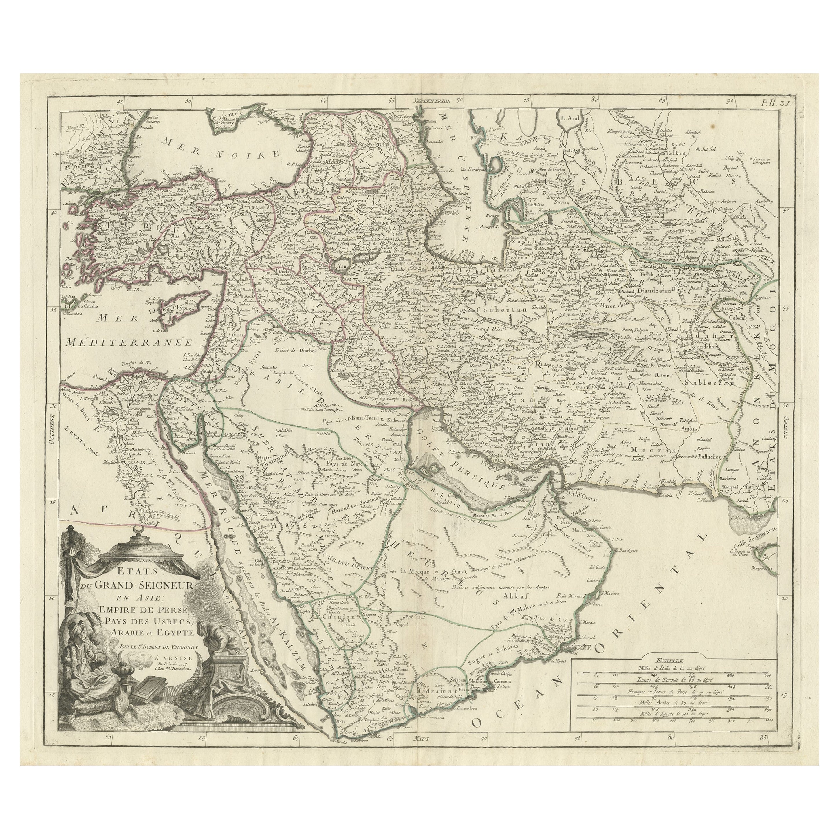
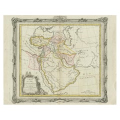
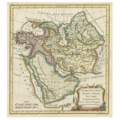
Antique map titled 'Perse, Turquie Asiatique et Arabie (..)'. Map of the Middle East with a large Arabia, extending from the Black Sea to the Indian Ocean and from the Red Sea to Persia and Iraq. Small but decorative cartouche and a very elaborate border. Published 1799.
- Dimensions:Height: 11.03 in (28 cm)Width: 15.63 in (39.7 cm)Depth: 0.02 in (0.5 mm)
- Materials and Techniques:Paper,Engraved
- Period:
- Date of Manufacture:1799
- Condition:General age-related toning. Original folding line. Minor wear and soiling, blank verso. Please study image carefully.
- Seller Location:Langweer, NL
- Reference Number:Seller: BG-13366-31stDibs: LU3054333938172
About the Seller
5.0
Recognized Seller
These prestigious sellers are industry leaders and represent the highest echelon for item quality and design.
Platinum Seller
Premium sellers with a 4.7+ rating and 24-hour response times
Established in 2009
1stDibs seller since 2017
2,816 sales on 1stDibs
Typical response time: 1 hour
- ShippingRetrieving quote...Shipping from: Langweer, Netherlands
- Return Policy
More From This Seller
View AllAntique Map of the Middle East by Brion de la Tour
1772
Located in Langweer, NL
Antique map titled 'Carte des Pays et Principaux Lieux (..)'. Original antique map of Middle East, extending to the Red Sea, Egypt, the Eastern Medi...
Category
Antique Late 18th Century Maps
Materials
Paper
$624 Sale Price
20% Off
Detailed Original Antique Map of the Turkish Empire with Arabia, 1778
Located in Langweer, NL
Title: Etats Due Grand-Seigneur En Asie, Empire De Perse, Pays Des Usbecs, Arabie et Egypte . . . 1753
Detailed map of the Turkish Empire, extending to the Black Sea, Georgia, the...
Category
Antique 1770s French Maps
Materials
Paper

Antique Map of the Arabian Peninsula by Bonne
c.1780
Located in Langweer, NL
Antique map titled 'Carte de l'Arabie, du Golfe Persique, et de la Mer Rouge (..)'. Original antique map of the Arabian Peninsula, including the horn...
Category
Antique Late 18th Century Maps
Materials
Paper

$528 Sale Price
20% Off
Old Map Depicting Turkey, Persia, Arab and Black Sea Etc, 1778
Located in Langweer, NL
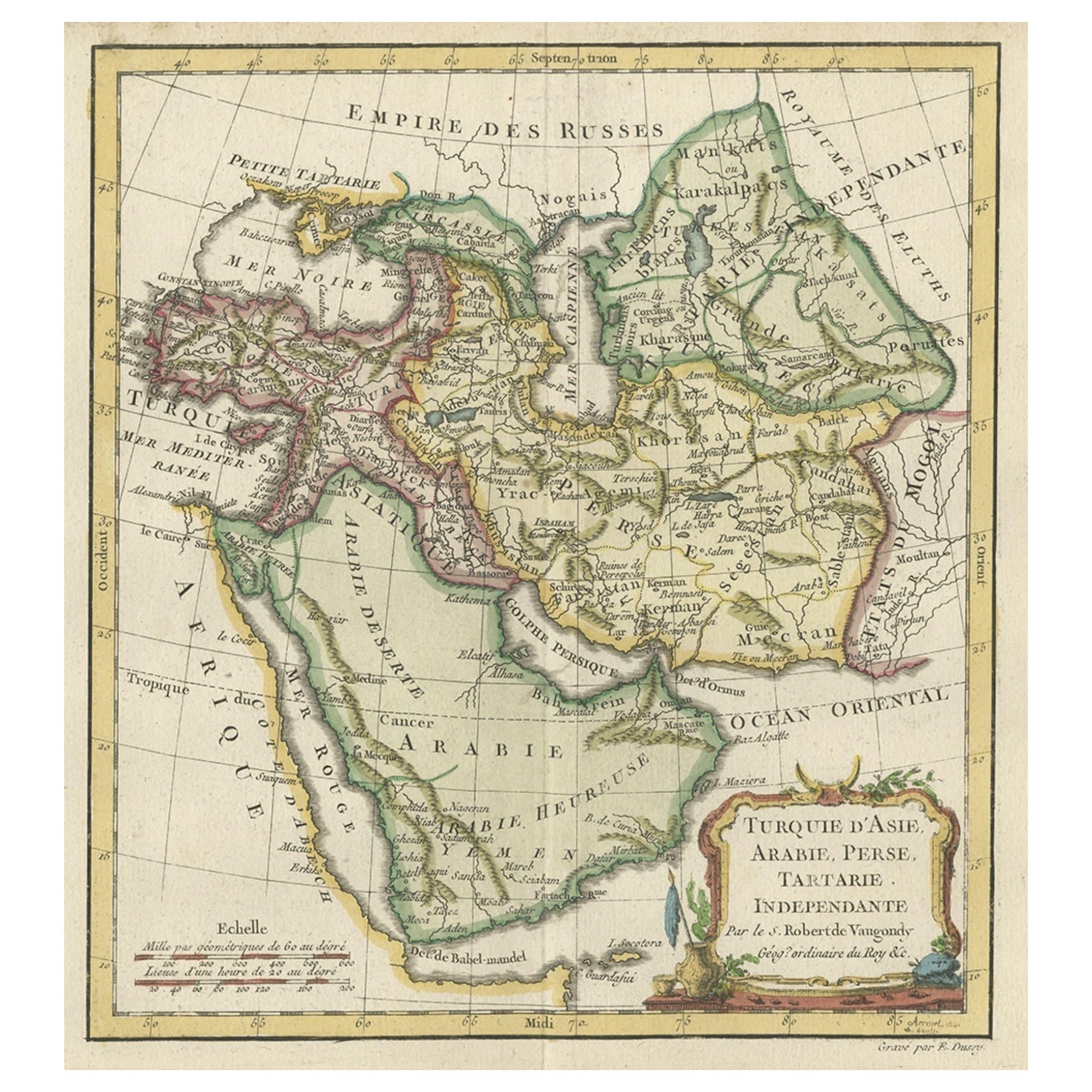
Antique map titled 'Turquie d'Asie, Arabie, Perse, Tartarie Independante'.
Old map of Turkey in Asia. The map shows all of Turkey and the Black Sea, and extends east to include t...
Category
Antique 1770s Maps
Materials
Paper
$518 Sale Price
20% Off
Finely Engraved Historical Map of Middle East and Asia, c.1745
Located in Langweer, NL
Description: Antique map titled'Theatrum Historicum pars Orientalis.'
Finely engraved historical map with a profusion of details. It shows the Middle East and Asia. Decorative ti...
Category
Antique 1740s Maps
Materials
Paper

Antique Map of Western Asia by Van Dùren
1752
Located in Langweer, NL
Antique map titled 'Neue Geographische Vorstellung von Asien'. Original antique map of Western Asia. This map originates from 'Neue Sammlung der merkwürdigsten Reisegeschichten, inso...
Category
Antique Mid-18th Century Maps
Materials
Paper

$432 Sale Price
20% Off
You May Also Like
Persia, Armenia
Adjacent Regions: A 17th Century Hand-colored Map by De Wit
By Frederick de Wit
Located in Alamo, CA
A large 17th century hand colored copperplate engraved map entitled "Novissima nec non Perfectissima Scandinaviae Tabula comprehendens Regnorum Sueciae, Daniae et Norvegiae distincte...
Category
Antique Late 17th Century Dutch Maps
Materials
Paper

$1,500 Sale Price
20% Off
Map of the Holy Land "Carte de la Syrie et de l
Egypte" by Pierre M. Lapie
By Pierre M. Lapie
Located in Alamo, CA
An early 19th century map of ancient Syria and Egypt entitled "Carte de la Syrie et de l'Egypte anciennes/dressée par M. Lapie, Colonel d'Etat Major, et...
Category
Antique Early 19th Century French Maps
Materials
Paper

$620 Sale Price
20% Off
Antique French Map of Asia Including China Indoneseia India, 1783
Located in Amsterdam, Noord Holland
Very nice map of Asia. 1783 Dedie au Roy.
Additional information:
Country of Manufacturing: Europe
Period: 18th century Qing (1661 - 1912)
Condition: Overall Condition B (Good Used)...
Category
Antique 18th Century European Maps
Materials
Paper

$486 Sale Price
40% Off
Antique Map of Eastern Hemisphere from the collection of Thierry Despont
Located in New York, NY
Designed by Enrico Bonetti (E. Bonatti) and published by Francesco Vallardi Editore. Based on an earlier map by Evangelista Azzi (Ev. Azzi). Labeled as such at bottom edge of map.
T...
Category
Antique Late 19th Century Italian Maps
Materials
Canvas, Wood

London 1744 Published Watercolour Antique Map of East Africa by Eman Bowen
Located in West Sussex, Pulborough
We are delighted to offer for sale this New and Accurate Map of Nubia & Abissinia, together with all the Kingdoms Tributary Thereto, and bordering upon them published in 1744 by Emanuel Bowen
This is a decorative antique engraved map of East Africa...
Category
Antique 1740s English George III Maps
Materials
Paper

1790 Thomas Stackhouse Map, Entitled "Russia in Europe, " , Ric.a004
Located in Norton, MA
1790 Thomas Stackhouse map, entitled
"Russia in Europe"
Ric.a004
Stackhouse, Thomas
Russia in Europe [map]
London: T. Stackhouse, 1783. Map. Matted hand-colored copper engraving. Image size: 14.5 x 15.25 inches. Mat size: 22.75 x 23.75 inches. A beautiful example of this map of Eastern Europe...
Category
Antique 17th Century Unknown Maps
Materials
Paper

More Ways To Browse
Arabian Antique
Middle East Furniture
Georgetown Map
Hemisphere Antiques
J Matthews
Japanese Kite
Maltese Falcon
Map Tuscany
St Eustatius
Sumba Map
Used Furniture Denver Co
Used Furniture Leominster
Vintage Long Island Map
Vintage World Map Desk
Vintage World Map Mirror
Antique Furniture Toledo Ohio
Antique Maps Washington Dc
Blaeu World Map