Items Similar to Antique Map of the Netherlands by Guicciardini, 1582

Want more images or videos?
Request additional images or videos from the seller
1 of 5
Antique Map of the Netherlands by Guicciardini, 1582
$714.53
£529.22
€595
CA$977.45
A$1,063.76
CHF 563.90
MX$12,797.87
NOK 7,152.05
SEK 6,543.63
DKK 4,534
About the Item
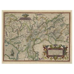
Antique map titled 'Hollandiae Cattorum Regionis Typus'. Early copper engraving of the Netherlands in the 2nd state, numbered 30 bottom right. This map originates from 'Description de touts les Pais Bas' by L. Guicciardini.
Artists and Engravers: Lodovico Guicciardini (1521-1589): an Italian merchant from aristocratic descent.
Condition: Good. Some foxing and age-related toning. Please study image carefully.
Date: 1582
Overall size: 38 x 29 cm.
Image size: 31 x 23 cm.
We sell original antique maps to collectors, historians, educators and interior decorators all over the world. Our collection includes a wide range of authentic antique maps from the 16th to the 20th centuries. Buying and collecting antique maps is a tradition that goes back hundreds of years. Antique maps have proved a richly rewarding investment over the past decade, thanks to a growing appreciation of their unique historical appeal. Today the decorative qualities of antique maps are widely recognized by interior designers who appreciate their beauty and design flexibility. Depending on the individual map, presentation, and context, a rare or antique map can be modern, traditional, abstract, figurative, serious or whimsical. We offer a wide range of authentic antique maps for any budget.
- Dimensions:Height: 11.42 in (29 cm)Width: 14.97 in (38 cm)Depth: 0 in (0.01 mm)
- Materials and Techniques:
- Period:
- Date of Manufacture:1582
- Condition:
- Seller Location:Langweer, NL
- Reference Number:Seller: BG-067291stDibs: LU3054327828402
About the Seller
5.0
Recognized Seller
These prestigious sellers are industry leaders and represent the highest echelon for item quality and design.
Platinum Seller
Premium sellers with a 4.7+ rating and 24-hour response times
Established in 2009
1stDibs seller since 2017
2,816 sales on 1stDibs
Typical response time: 1 hour
- ShippingRetrieving quote...Shipping from: Langweer, Netherlands
- Return Policy
More From This Seller
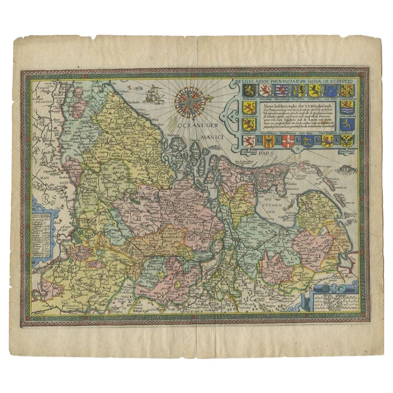
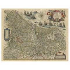
View AllAntique Map of the Netherlands by Guicciardini, 1612
Located in Langweer, NL
Antique map titled 'Belgicarum Provinciarum Nova Descriptio'. Beautiful old map of the Netherlands. With decorative cartouche including the coat...
Category
Antique 17th Century Maps
Materials
Paper
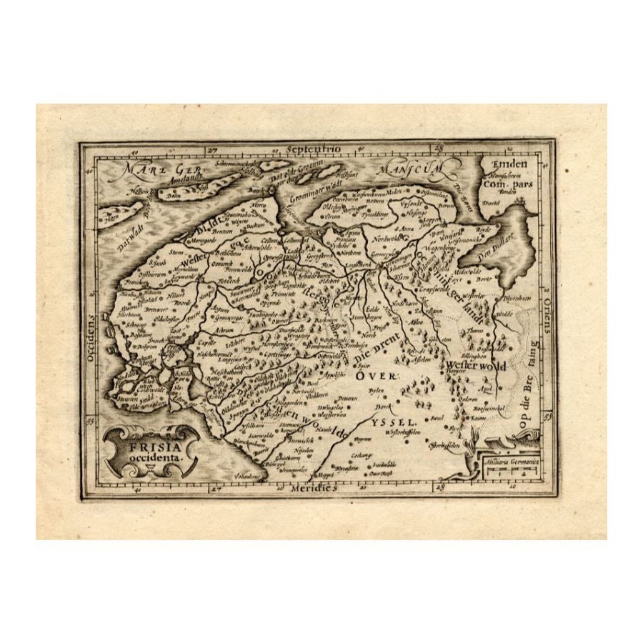
Antique Map of Friesland by Guicciardini, 1613
Located in Langweer, NL
Antique map titled 'Frisia Occidenta.' (Map of the province of Friesland, the Netherlands.) This original old antique print / plate originates from the scarse French edition of 'Desc...
Category
Antique 17th Century Maps
Materials
Paper
$269 Sale Price
20% Off
Old Antique Map of the Province of Friesland, the Netherlands, c.1580
Located in Langweer, NL
Antique map titled 'Frisia Occidentalis'. Old map of the province of Friesland, the Netherlands. This map is also known as the 'Pauwenkaart' ('peacock map'), referring to the peacock next to the inset map. Based on a manuscript map...
Category
Antique 16th Century Maps
Materials
Paper
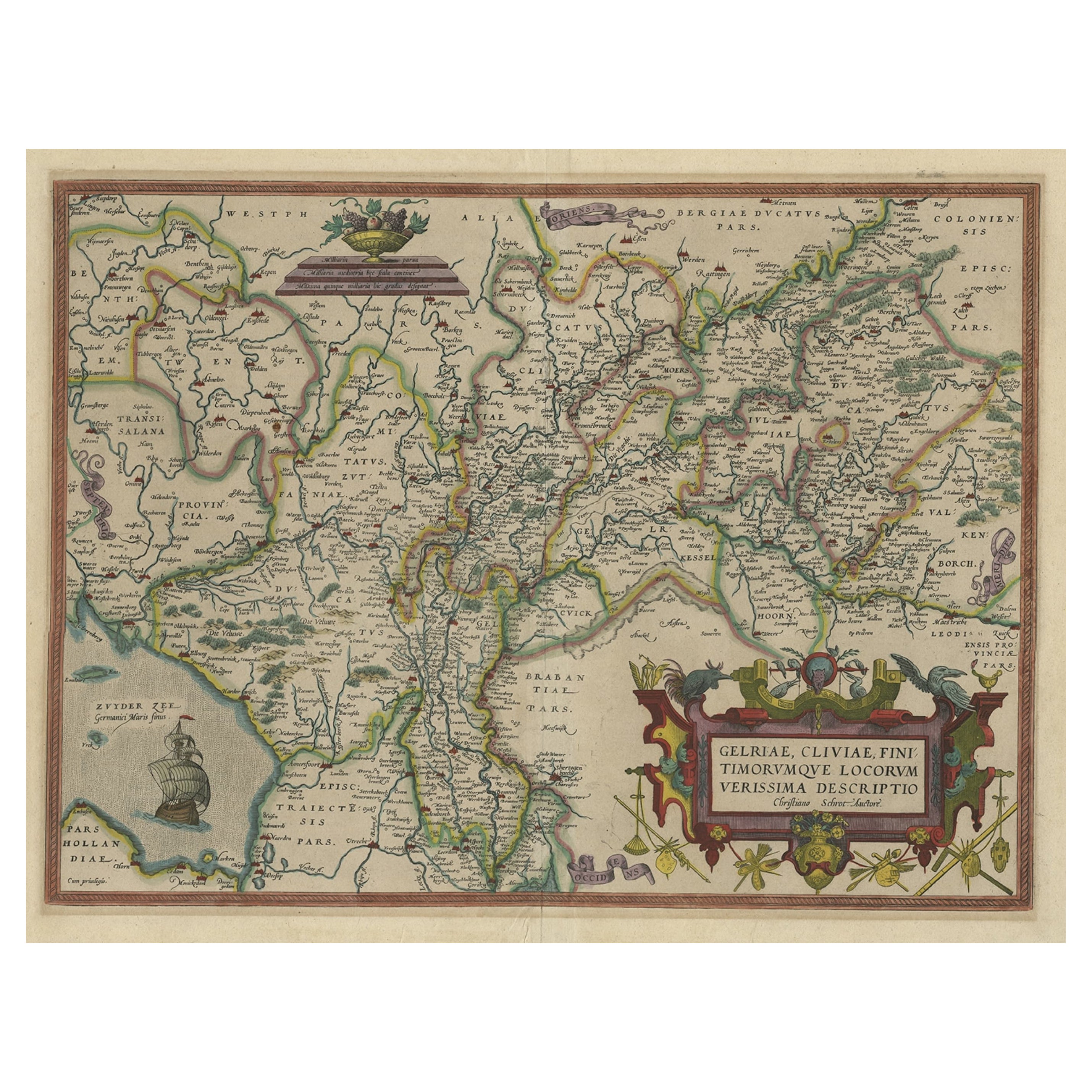
Superb Antique Map of the Province of Gelderland, the Netherlands, ca.1575
Located in Langweer, NL
Antique map titled 'Gelriae, Cliviae, Finitimorumque Locorum Verissima Descriptio Christiano Schrot. Auctore'.
This superb map is Ortelius' first plate covering Gelderland. It is b...
Category
Antique 16th Century Maps
Materials
Paper
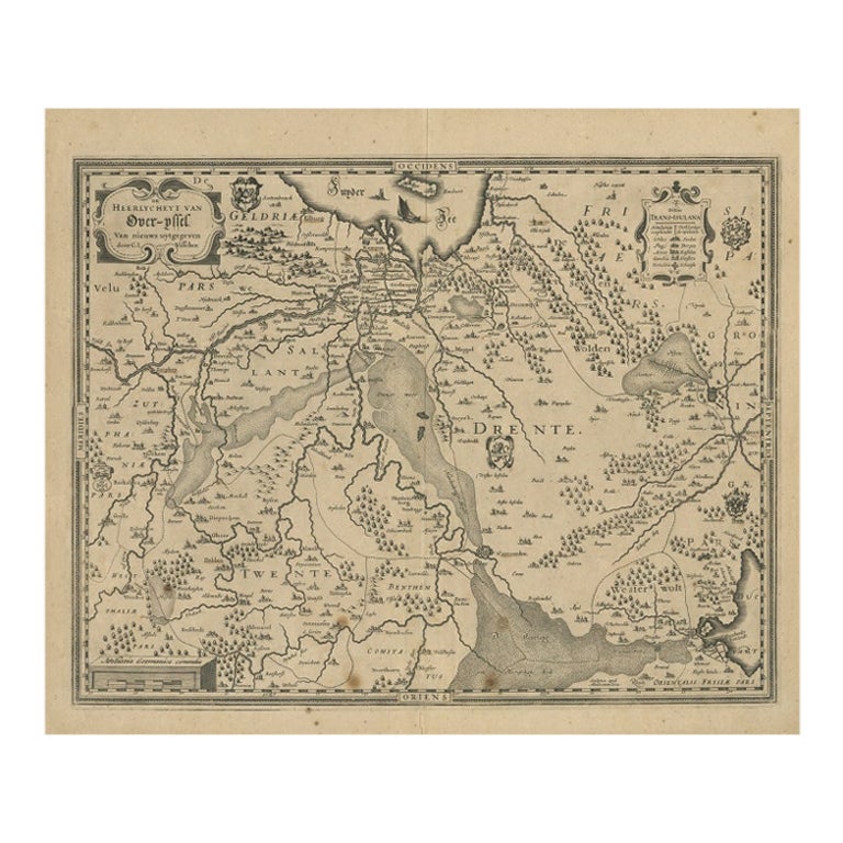
Antique Map of Overijssel by Visscher, 1632
Located in Langweer, NL
Antique map titled 'De Heerlyckheyt van Over-IJssel'. Old map of the province of Overijssel, the Netherlands. Also depicted are various coats of arms. Artists and Engravers: Engraved...
Category
Antique 17th Century Maps
Materials
Paper

$492 Sale Price
20% Off
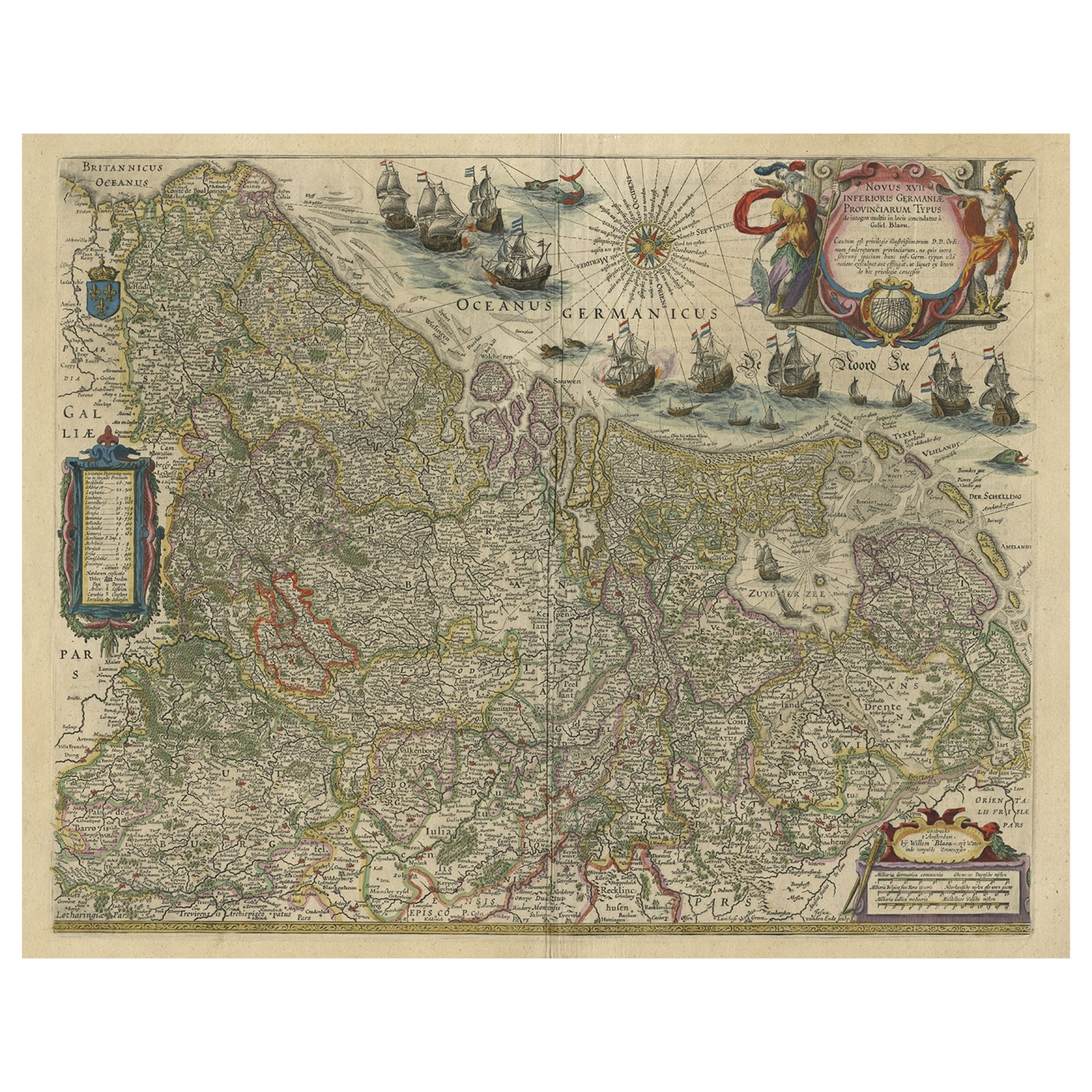
Handsome Old Detailed Map of the Low Countries by Famous Mapmaker Blaeu, ca.1635
Located in Langweer, NL
Antique map titled 'Novus XVII Inferioris Germaniae Provinciarum Typus'.
Handsome - and much sought after- detailed map of the Low Countries by the world most famous map maker Bla...
Category
Antique 1630s Maps
Materials
Paper
You May Also Like
Map of the Netherlands - Etching by G. Braun and F. Hogenberg -Late 16th Century
By Franz Hogenberg
Located in Roma, IT
Map of the Netherlands is an original etching realized by George Braun and Franz Hogenberg, as part of the "Civitates Orbis Terrarum".
The “Civitates Orbis Terrarum” (Atlas of Citi...
Category
16th Century Figurative Prints
Materials
Etching

1643 Willem&Joan Blaeu Map NW Flanders "Flandriae Teutonicae Pars Prientalior
Located in Norton, MA
1643 Willem and Joan Blaeu map of northwest Flanders, entitled
"Flandriae Teutonicae Pars Prientalior,"
Ric0012
" Authentic" - Map of the northwest Fl...
Category
Antique 17th Century Dutch Maps
Materials
Paper

1635 Willem Blaeu Map of Northern France"Comitatvs Bellovacvm" Ric.a08
Located in Norton, MA
1635 Willem Blaeu map of northern France, entitled.
"Comitatvs Bellovacvm Vernacule Beavvais,"
Colored
Ric.a008
“COMITATVS BELLOVACVM…” Amsterdam: W...
Category
Antique 17th Century Unknown Maps
Materials
Paper

Map of Antwerp - Etching by G.Braun and F. Hogenberg -Late 16th century
By Franz Hogenberg
Located in Roma, IT
This Map of Anverpia is an original etching hand colored realized by George Braun and Franz Hogenberg as part of the famous Atlas "Civitates Orbis Ter...
Category
16th Century Old Masters Figurative Prints
Materials
Etching

1590 Ortelius Map of Calais and Vermandois, France and Vicinity Ric.a014
Located in Norton, MA
1590 Ortelius map of
Calais and Vermandois, France and Vicinity
Ric.a014
Two rare regional Abraham Ortelius maps on a single folio sheet. Left map, entitled Caletensium, depic...
Category
Antique 16th Century Dutch Maps
Materials
Paper

1627 Hendrik Hondius Map Entitled "Vltoniae Orientalis Pars, " Ric.a009
Located in Norton, MA
1627 Hendrik Hondius map entitled
"Vltoniae orientalis pars,"
Ric.a009
Title:
Vltoniae orientalis : pars
Title (alt.) :
Ultoniae orientalis pars
Creator:
Mercator, Gerh...
Category
Antique 17th Century Dutch Maps
Materials
Paper

More Ways To Browse
Antique Map Vietnam
Antique Maps Colorado
Antique Maps Of Kansas
Antique Marine Maps
Antique World Globe Map
Garde Corps
Marie Galante
Nevada Antique Map
Nova Scotia Antique Furniture
Patagonia Map
Antique Furniture South Carolina
Antique Map Of Boston
Antique Map Of Venice
Antique Maps Of Maryland
Charlotte Reine
Cleveland Antique Furniture
Gambia Antique Map
Johann Baptist Homann On Sale