Items Similar to Antique Map of New Jersey, Delaware and Maryland by Johnson, 1872

Want more images or videos?
Request additional images or videos from the seller
1 of 5
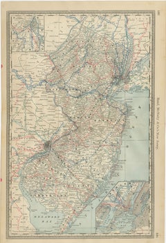
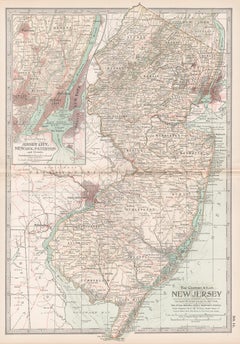
Antique Map of New Jersey, Delaware and Maryland by Johnson, 1872
$287.99
$359.9920% Off
£213.42
£266.7720% Off
€240
€30020% Off
CA$393.60
CA$49220% Off
A$428.46
A$535.5820% Off
CHF 227.43
CHF 284.2920% Off
MX$5,155.33
MX$6,444.1720% Off
NOK 2,881.83
NOK 3,602.2820% Off
SEK 2,640.57
SEK 3,300.7120% Off
DKK 1,828.15
DKK 2,285.1920% Off
About the Item
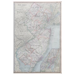
Antique map titled 'Johnson's New Jersey (..). Two maps on one sheet showing New Jersey, Delaware and Maryland. With inset map of the district of Columbia. This map originates from 'Johnson's New Illustrated Family Atlas of the World' by A.J. Johnson. Published 1872.
- Dimensions:Height: 18.12 in (46 cm)Width: 26.38 in (67 cm)Depth: 0.02 in (0.5 mm)
- Materials and Techniques:
- Period:
- Date of Manufacture:1872
- Condition:General age-related toning, shows minor wear and creasing. Some soiling. Original folding line. English text on verso. Please study images carefully.
- Seller Location:Langweer, NL
- Reference Number:Seller: BG-12592-391stDibs: LU3054321467652
About the Seller
5.0
Recognized Seller
These prestigious sellers are industry leaders and represent the highest echelon for item quality and design.
Platinum Seller
Premium sellers with a 4.7+ rating and 24-hour response times
Established in 2009
1stDibs seller since 2017
2,816 sales on 1stDibs
Typical response time: 1 hour
- ShippingRetrieving quote...Shipping from: Langweer, Netherlands
- Return Policy
More From This Seller
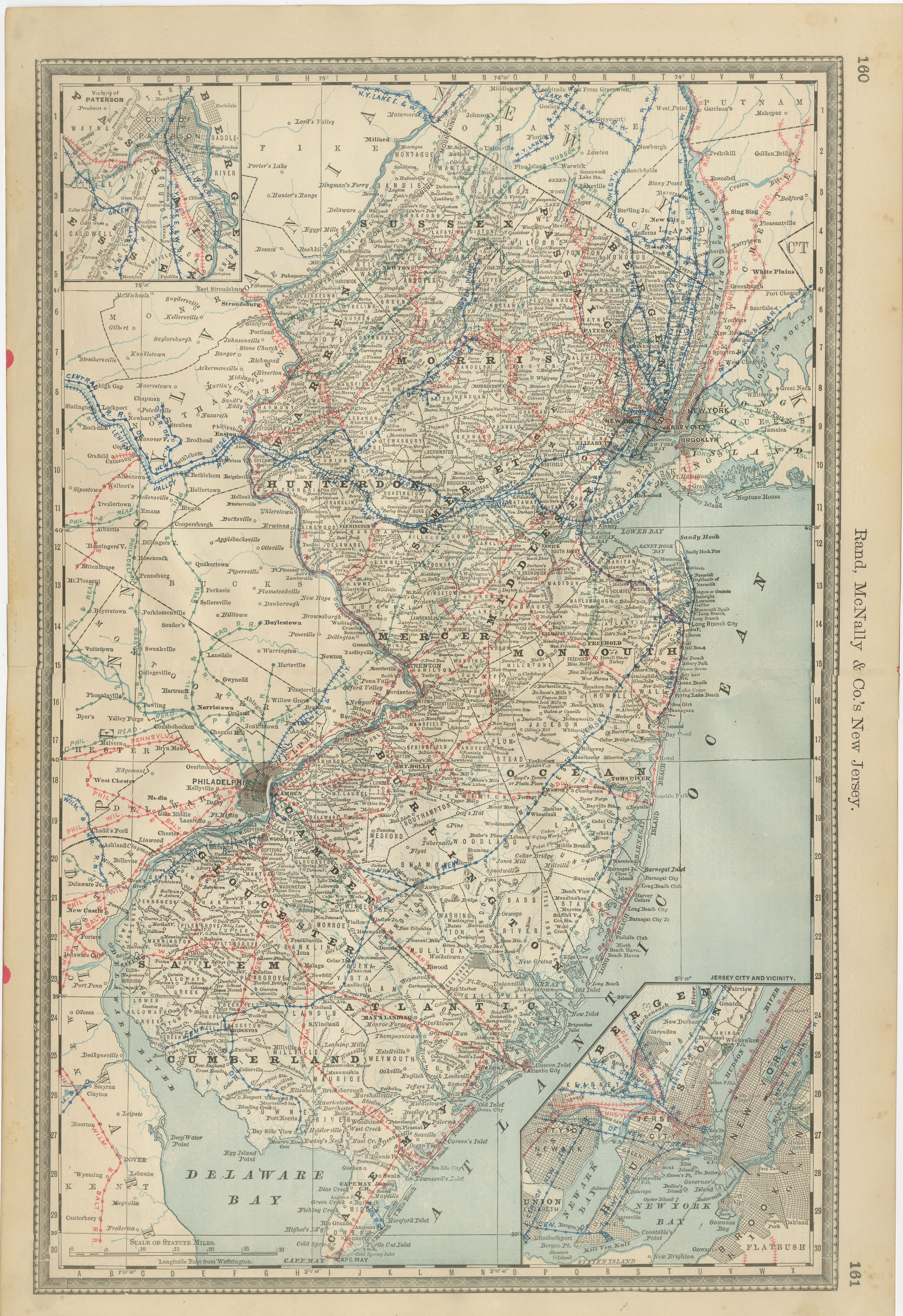
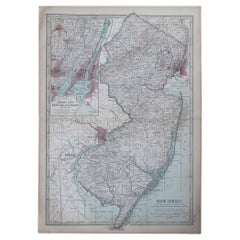
View AllNew Jersey Antique Map – The Garden State, Railroads
Counties, c.1888
Located in Langweer, NL
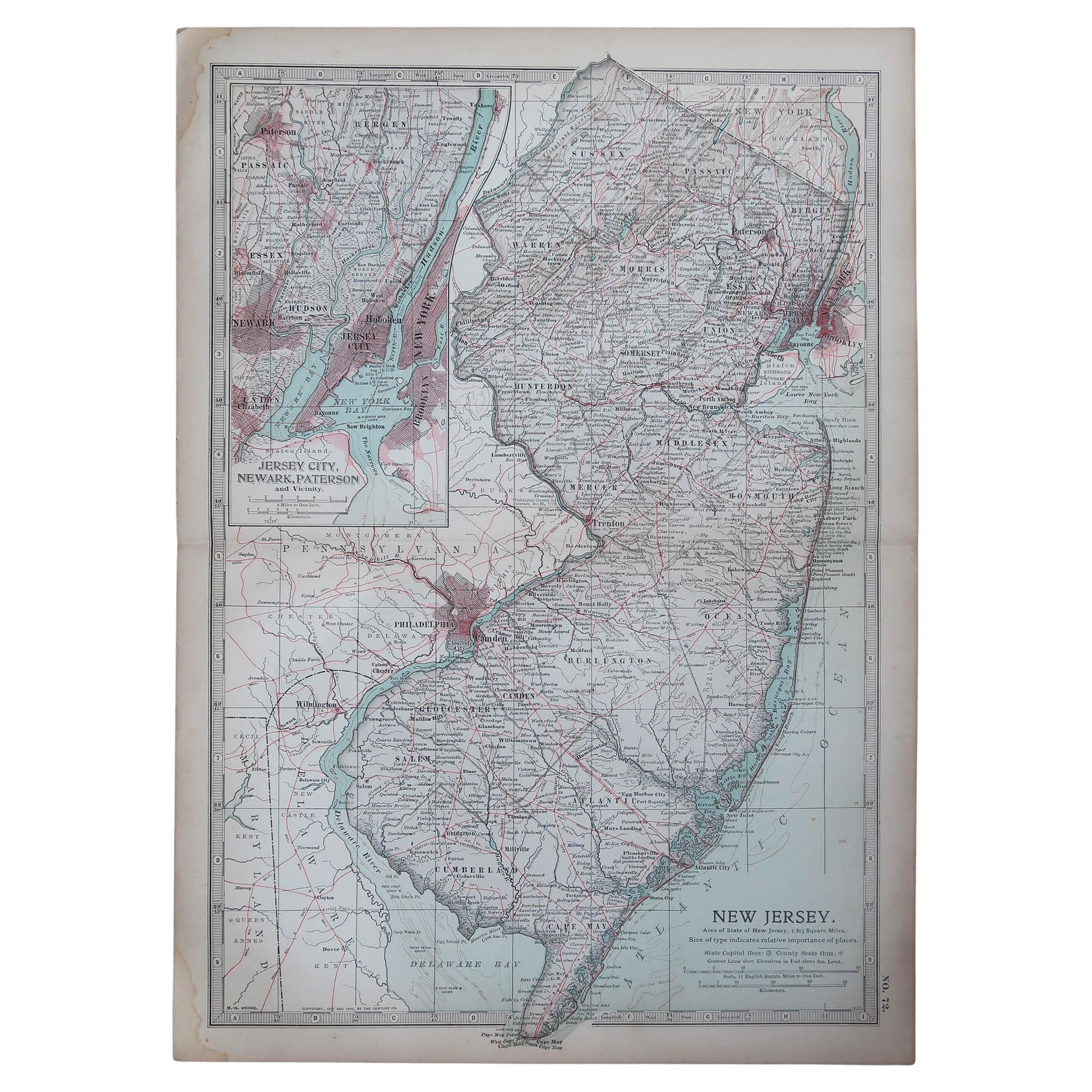
Antique Map of New Jersey – Rand McNally, circa 1888
This antique map of New Jersey was published by Rand, McNally & Co. around 1888. It offers a detailed late 19th-century portrait...
Category
Antique Late 19th Century American Maps
Materials
Paper
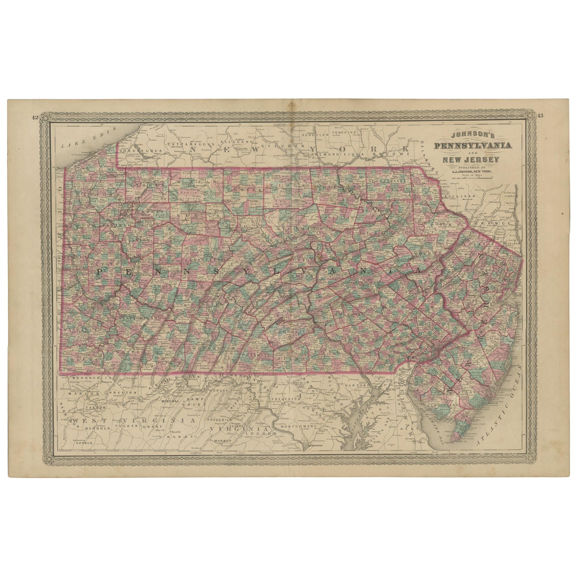
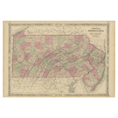
Antique Map of Pennsylvania and New Jersey by Johnson, 1872
Located in Langweer, NL
Antique map titled 'Johnson's Pennsylvania and New Jersey'. Original map showing Pennsylvania and New Jersey. This map originates from 'Johnson's New Illustrated Family Atlas of the ...
Category
Antique Late 19th Century Maps
Materials
Paper

Antique Map of New Jersey
Located in Langweer, NL
Antique map titled 'Colton's New Jersey'. This rare hand colored map of New Jersey is a copper plate engraving dating to 1855. Produced by the import...
Category
Antique Mid-19th Century Maps
Materials
Paper

$191 Sale Price
20% Off
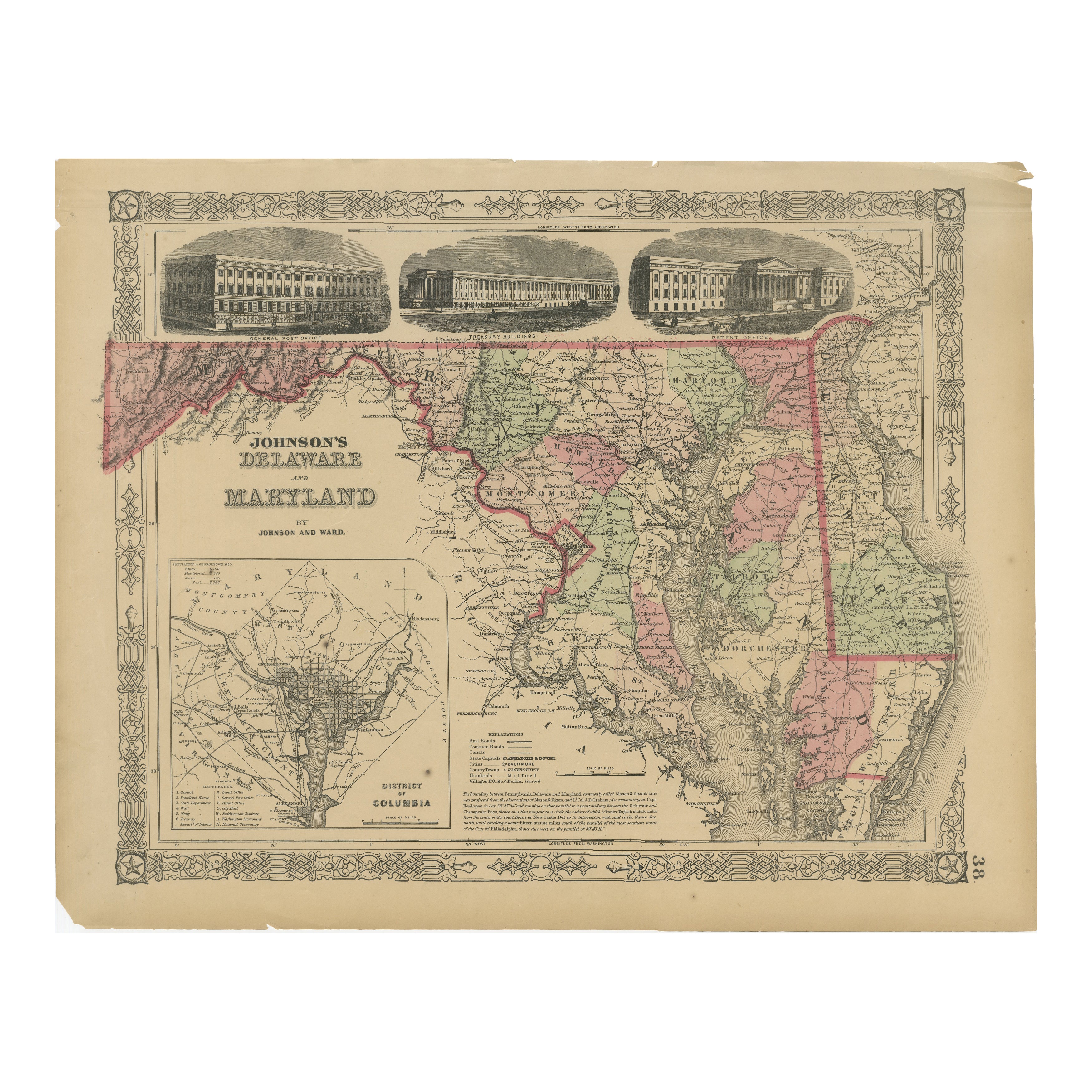
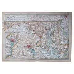
Delaware and Maryland Map – Johnson, Hand-Colored with Insets, 1864
Located in Langweer, NL
Johnson’s Delaware and Maryland Map, USA c.1864 – Hand-Colored with Insets
This is a finely engraved and hand-colored map titled Johnson’s Delaware and Maryland, published by Johnso...
Category
Antique Mid-19th Century American Maps
Materials
Paper
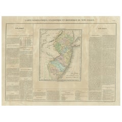
Original Antique Map of the State of New Jersey Published in France
Located in Langweer, NL
Original antique map titled 'Carte Géographique Statistique et Historique du New-Jersey'. One of the earliest obtainable maps of the State of New Jersey published outside of the Unit...
Category
Antique Early 19th Century Maps
Materials
Paper
$191 Sale Price
20% Off
Historic 1864 Civil War Map of Pennsylvania and New Jersey with Coastal Focus
Located in Langweer, NL
Title: Historic 1864 Civil War Map of Pennsylvania and New Jersey with Coastal Focus
Description: This meticulously crafted antique map, titled "Johnson's Pennsylvania and New Jerse...
Category
Antique 1860s Maps
Materials
Paper
You May Also Like
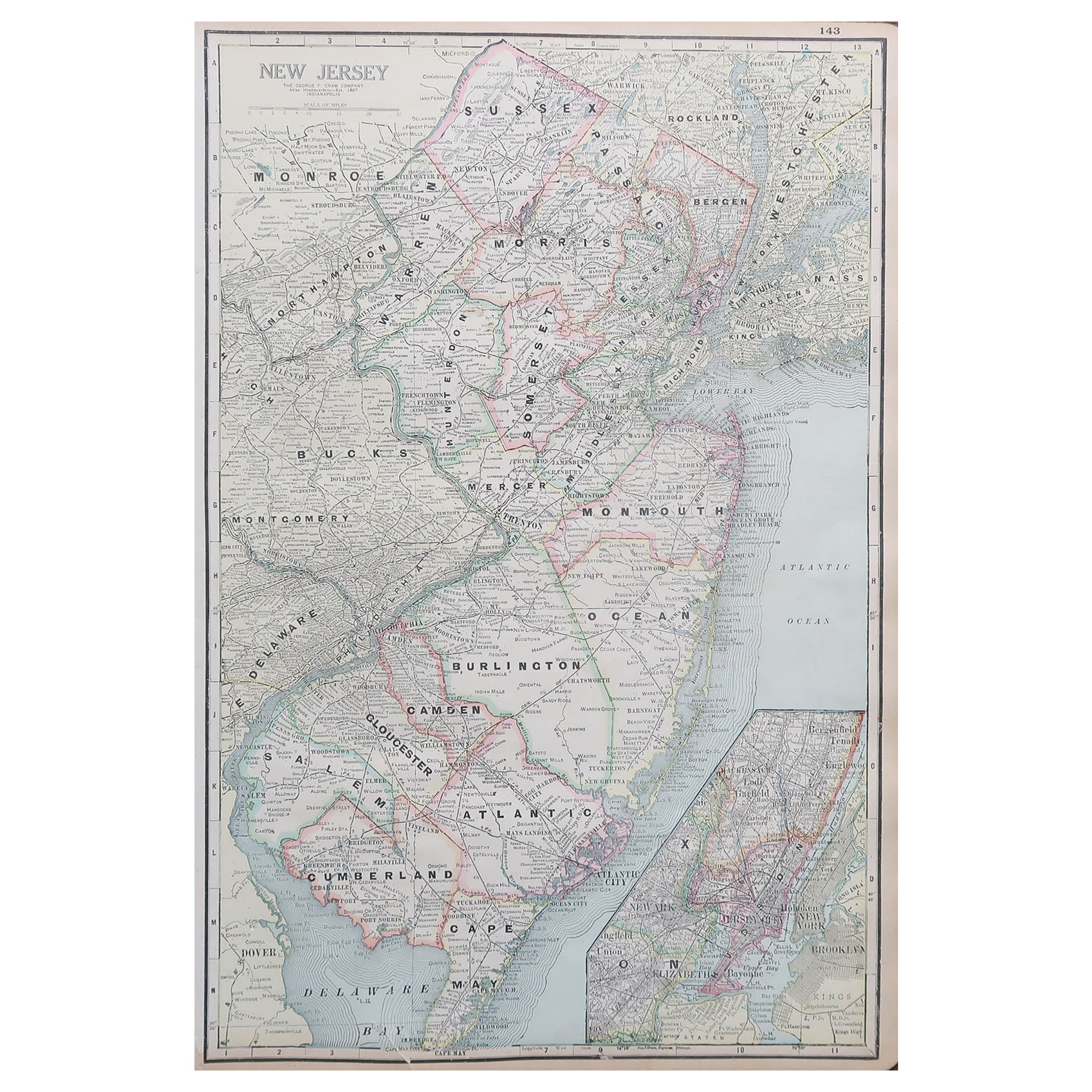
Large Original Antique Map of New Jersey, USA, circa 1900
Located in St Annes, Lancashire
Fabulous map of New Jersey
Original color
Engraved and printed by the George F. Cram Company, Indianapolis.
Published, circa 1900
Unframed
Repairs to minor edge tears
Category
Antique 1890s American Maps
Materials
Paper
Original Antique Map of the American State of New Jersey, 1903
Located in St Annes, Lancashire
Antique map of New Jersey
Published By A & C Black. 1903
Original colour
Good condition
Unframed.
Free shipping
Category
Antique Early 1900s English Maps
Materials
Paper
Original Antique Map of the American State of Maryland
Delaware, 1903
Located in St Annes, Lancashire
Antique map of Maryland And Delaware
Published By A & C Black. 1903
Original colour
Good condition
Unframed.
Free shipping
Category
Antique Early 1900s English Maps
Materials
Paper
New Jersey. USA Century Atlas state antique vintage map
Located in Melbourne, Victoria
'The Century Atlas. New Jersey'
Original antique map, 1903.
Central fold as issued. Map name and number printed on the reverse corners.
Sheet 40cm by 29.5cm.
Category
Early 20th Century Victorian More Prints
Materials
Lithograph
Maryland and Delaware. USA. Century Atlas state antique vintage map
Located in Melbourne, Victoria
'The Century Atlas. Maryland and Delaware.'
Original antique map, 1903.
Central fold as issued. Map name and number printed on the reverse corners.
Sheet 29.5cm by 40cm.
Category
Early 20th Century Victorian More Prints
Materials
Lithograph
Original Antique Map of the American State of Pennsylvania( Eastern Part ), 1903
Located in St Annes, Lancashire
Antique map of Pennsylvania ( Eastern part )
Published By A & C Black. 1903
Original colour
Good condition
Unframed.
Free shipping
Category
Antique Early 1900s English Maps
Materials
Paper

More Ways To Browse
Antique Delaware
Antique Furniture Delaware
New Jersey 19th Century
New Jersey Antique Furniture
Antique Maps Of Maryland
Map Railroad
Antique Railroad Maps
Antique Maps Of Greece
Brazilian Antiques
Turkey Map
Map Of Japan
Antique Nautical Charts
Denmark Map
Antique Macedonia
Hemispheres Map
Java Map
Miniature Maps
Antique Maps Of Wales