Items Similar to Antique Map of North America – Physical Relief Map by Hachette c.1883


Video Loading
Want more images or videos?
Request additional images or videos from the seller
1 of 11
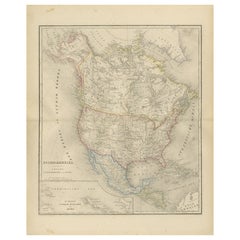
Antique Map of North America – Physical Relief Map by Hachette c.1883
$468.35
£346.88
€390
CA$640.68
A$697.26
CHF 369.61
MX$8,388.52
NOK 4,687.90
SEK 4,289.10
DKK 2,971.87
About the Item
Antique Map of North America – Physical Relief Map by Hachette c.1883
Description:
This antique map titled “Amérique du Nord” was published around 1883 by E. Hachette in Paris as part of their renowned “Atlas en relief.” The map presents North America with vivid hypsometric tints to indicate elevation, showing physical features such as the Rocky Mountains, Appalachian Mountains, Sierra Madre, Central Plains, Canadian Shield, and coastal lowlands in clear relief.
The map extends from Greenland in the northeast to Central America in the south, and from the Pacific islands in the west to the Caribbean islands in the east. It labels key regions such as Alaska (shown here as part of the United States following its purchase from Russia in 1867), Canada, Mexico, and the entire contiguous United States with state boundaries outlined.
An inset at top right shows a size comparison of France to eastern North America, highlighting the geographical scale for educational purposes. The title is presented in French, and the legend at lower left categorises elevations from depressions below sea level up to mountain ranges above 5000 metres.
Condition:
Very good condition with original hand colour preserved. Light age-toning and minor foxing in margins consistent with age. Ready for framing.
Framing tip:
This beautifully coloured educational map is ideal for framing in a simple oak or black wood frame to enhance its academic and historical aesthetic. Perfect for libraries, offices, geography enthusiasts, or anyone celebrating North American heritage and cartographic history.
- Dimensions:Height: 10.12 in (25.7 cm)Width: 12.84 in (32.6 cm)Depth: 0.01 in (0.2 mm)
- Materials and Techniques:
- Place of Origin:
- Period:
- Date of Manufacture:circa 1883
- Condition:Very good condition with original hand colour preserved. Light age-toning and minor foxing in margins consistent with age. Ready for framing.
- Seller Location:Langweer, NL
- Reference Number:Seller: BG-13384-311stDibs: LU3054345658022
About the Seller
5.0
Recognized Seller
These prestigious sellers are industry leaders and represent the highest echelon for item quality and design.
Platinum Seller
Premium sellers with a 4.7+ rating and 24-hour response times
Established in 2009
1stDibs seller since 2017
2,816 sales on 1stDibs
Typical response time: 1 hour
- ShippingRetrieving quote...Shipping from: Langweer, Netherlands
- Return Policy
More From This Seller
View AllAntique Map of North America by A
C. Black, 1870
Located in Langweer, NL
Antique map titled 'North America'. Original antique map of North America. This map originates from ‘Black's General Atlas of The World’. Published by A & C. Black, 1870.
Category
Antique Late 19th Century Maps
Materials
Paper

$264 Sale Price
20% Off
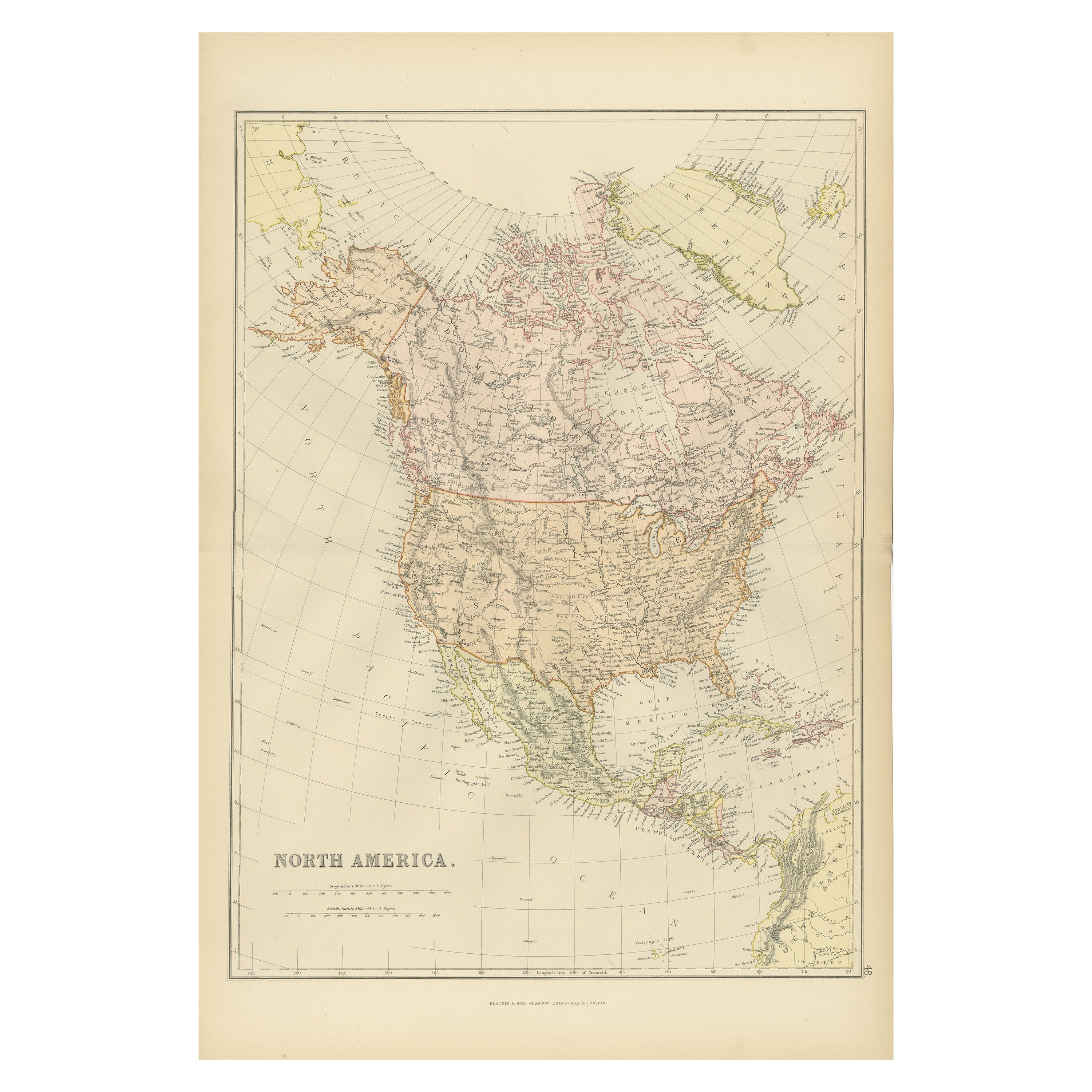
Antique Decorative Coloured Map of North America, 1882
Located in Langweer, NL
This original antique map of North America is from the Blackie & Son Atlas published in 1882. Here are several points of interest about this map:
1. **Political Borders**: The map l...
Category
Antique 1880s Maps
Materials
Paper

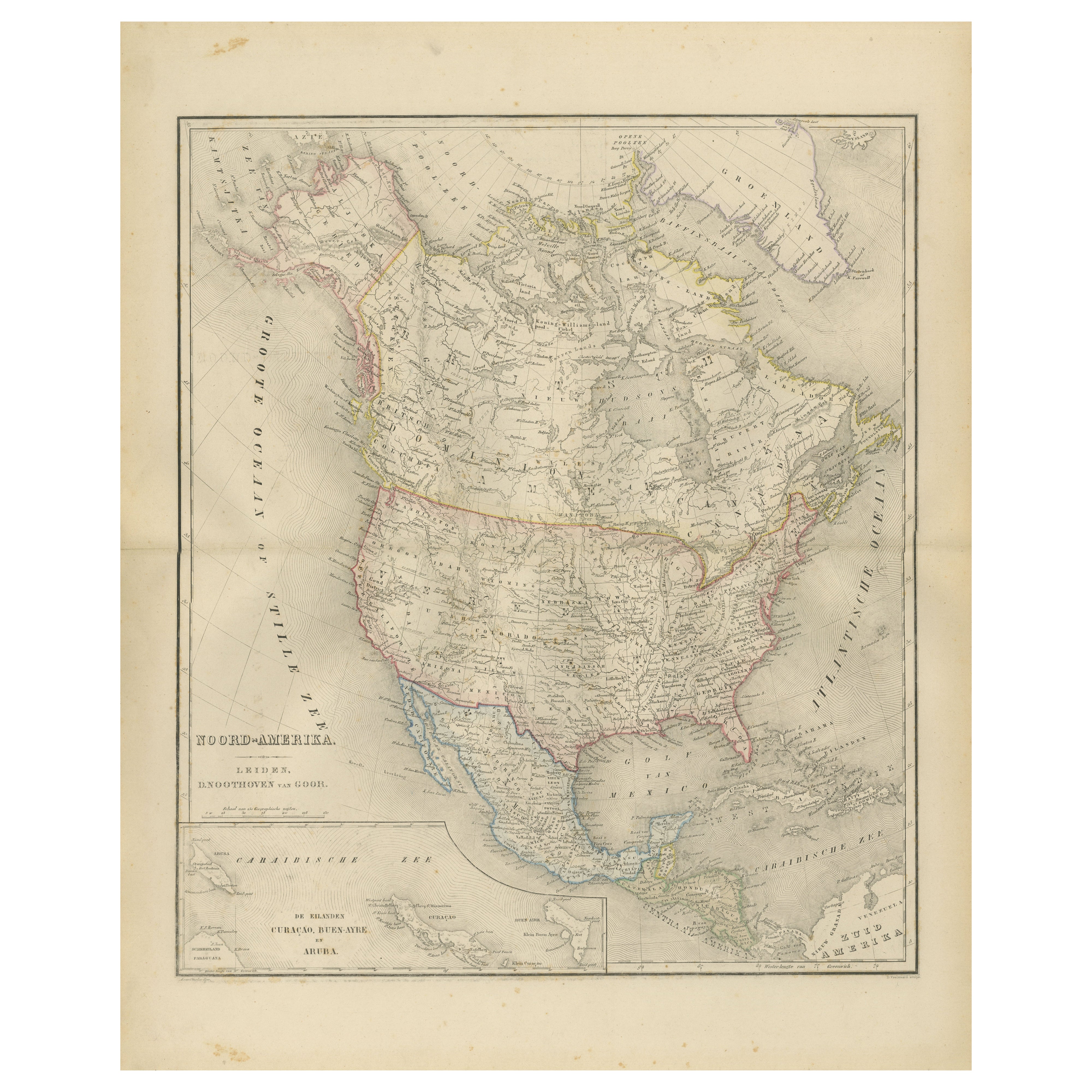
North America Map with USA, Canada
Mexico – Nieuwe Hand-Atlas, 1876
Located in Langweer, NL
North America Map with USA, Canada & Mexico – Nieuwe Hand-Atlas, 1876
This finely engraved 19th-century map of “Noord-Amerika,” published in 1876 by D. Noothoven van Goor of Leiden ...
Category
Antique 1870s Dutch Maps
Materials
Paper
Explore North America in 1903 - Intricately Detailed Antique Map
Located in Langweer, NL
North America, 1903 - A Colorful Historical Map with Detailed Borders
This attractive map of North America was engraved, printed, and published by W. & A.K. Johnston in 1903. A wond...
Category
Early 20th Century Maps
Materials
Paper
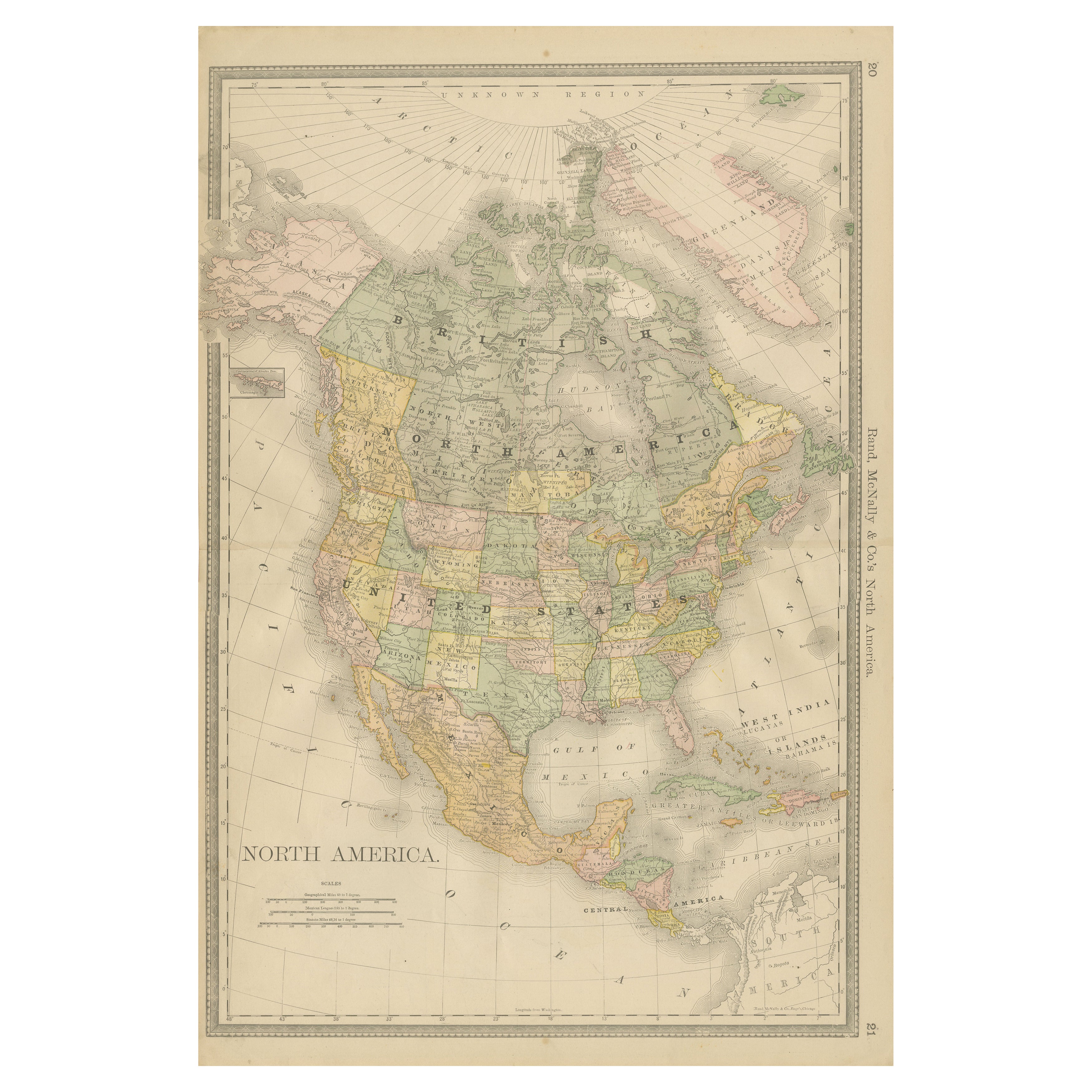
North America Antique Railroad Map c.1888 – U.S., Canada
Mexico
Located in Langweer, NL
Antique Map of North America – Rand McNally, circa 1888
This antique map of North America, published by Rand, McNally & Co. circa 1888, offers a comprehensive view of the continent ...
Category
Antique Late 19th Century American Maps
Materials
Paper
Antique Map of the United States of North America, c.1882
Located in Langweer, NL
Antique map titled 'United States of North America'. Old map of the United States of North America. This map originates from 'The Royal Atlas of Modern Geography, Exhibiting, in a Se...
Category
Antique 1880s Maps
Materials
Paper

You May Also Like
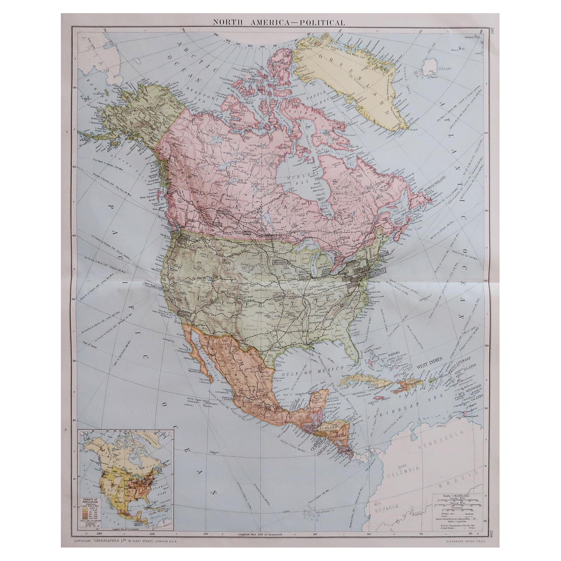
Large Original Vintage Map of North America, circa 1920
Located in St Annes, Lancashire
Great map of North America
Original color. Good condition
Published by Alexander Gross
Unframed.
Category
Vintage 1920s English Edwardian Maps
Materials
Paper

North America. Century Atlas antique vintage map
Located in Melbourne, Victoria
'The Century Atlas. North America'
Original antique map, 1903.
Central fold as issued. Map name and number printed on the reverse corners.
Sheet 40cm by 29.5cm.
Category
Early 20th Century Victorian More Prints
Materials
Lithograph

Original Antique Map of North America by Dower, circa 1835
Located in St Annes, Lancashire
Nice map of North America
Drawn and engraved by J.Dower
Published by Orr & Smith. C.1835
Unframed.
Free shipping
Category
Antique 1830s English Maps
Materials
Paper

Early 19th Century Hand Coloured Map of North America by Aaron Arrowsmith
By Aaron Arrowsmith
Located in Hamilton, Ontario
Hand coloured map in French by English cartographer Aaron Arrowsmith (1750–1823) titled "Amerique Septentionale" (North America).
Map size: 9.5" x 8"
Mat size: 20.5" x 14.25".
Category
Antique Early 19th Century English Maps
Materials
Paper

$795 Sale Price
36% Off
1864 Map of North America, Antique Hand-Colored Map, by Adolphe Hippolyte Dufour
Located in Colorado Springs, CO
Offered is a map of North America entitled Amerique du Nord from 1864. This rare, separately published wall map was produced by Adolphe Hippolyte Dufour. This map includes vibrant an...
Category
Antique 1860s French Maps
Materials
Paper

Original Antique Map of The United States of America by Dower, circa 1835
Located in St Annes, Lancashire
Nice map of the USA
Drawn and engraved by J.Dower
Published by Orr & Smith. C.1835
Unframed.
Free shipping
Category
Antique 1830s English Maps
Materials
Paper

More Ways To Browse
Antique Victorian Dining Tables
Italian Plastic Chairs
Black Crystal Glasses
French Mid Century Modern Rug
China Silk Rug
Chrome Glass Coffee Tables
Antique Italian Chairs
Antique Walnut Bar
Beni Ourain Rugs
French Iron And Glass Table
Glass Top Wood Base Coffee Tables
T Chair
Antique Silver Basket
Antique Walkers
Ebony Wood Furniture
Opalescent Glass
Pair Of Danish Chairs
Veneer Dining Tables