Items Similar to Antique Map of the North-Western Part of France by Janssonius (c.1657)


Want more images or videos?
Request additional images or videos from the seller
1 of 5
Antique Map of the North-Western Part of France by Janssonius (c.1657)
$688.23
£511.37
€575
CA$942.73
A$1,028.47
CHF 545.48
MX$12,390.76
NOK 6,923.20
SEK 6,338.38
DKK 4,380.28
About the Item
Antique map of France titled 'Le Gouvernement de Calais'. Attractive map of the north-western part of France including the towns of Calais, Gravelines. This map originates from 'Atlas Novus, Sive Theatrum Orbis Orbis Terrarum: In quo Galliae, Helvetiae (..)' by J. Janssonius (1656-1657).
- Creator:Johannes Janssonius (Artist)
- Dimensions:Height: 19.69 in (50 cm)Width: 23.63 in (60 cm)Depth: 0.02 in (0.5 mm)
- Materials and Techniques:
- Period:Mid-17th Century
- Date of Manufacture:1657
- Condition:Wear consistent with age and use. General age-related toning. Some creasing around the folding line and minor foxing. Latin text on verso. Please study images carefully.
- Seller Location:Langweer, NL
- Reference Number:Seller: BG-12082-31stDibs: LU3054316431661
About the Seller
5.0
Recognized Seller
These prestigious sellers are industry leaders and represent the highest echelon for item quality and design.
Platinum Seller
Premium sellers with a 4.7+ rating and 24-hour response times
Established in 2009
1stDibs seller since 2017
2,819 sales on 1stDibs
Typical response time: 1 hour
- ShippingRetrieving quote...Shipping from: Langweer, Netherlands
- Return Policy
More From This Seller
View AllAntique Map of the Coast of Artois by Janssonius, 1657
By Johannes Janssonius
Located in Langweer, NL
Antique map of France titled 'Descriptio Boloniae, Pontieu'. Detailed map of the coast of Artois featuring the fortified cities of St. Valery-sur-Somme, Le Crotoy, Rue, Estaples, and...
Category
Antique 17th Century Maps
Materials
Paper
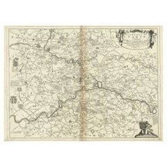
Antique Map of the Region of Picardy by Janssonius, 1657
By Johannes Janssonius
Located in Langweer, NL
Antique map of France titled 'Picardia vera et inferior'. Detailed map of the Picardy region of France. This map originates from 'Atlas Novus, Sive Theatrum Orbis Orbis Terrarum: In ...
Category
Antique Mid-17th Century Maps
Materials
Paper

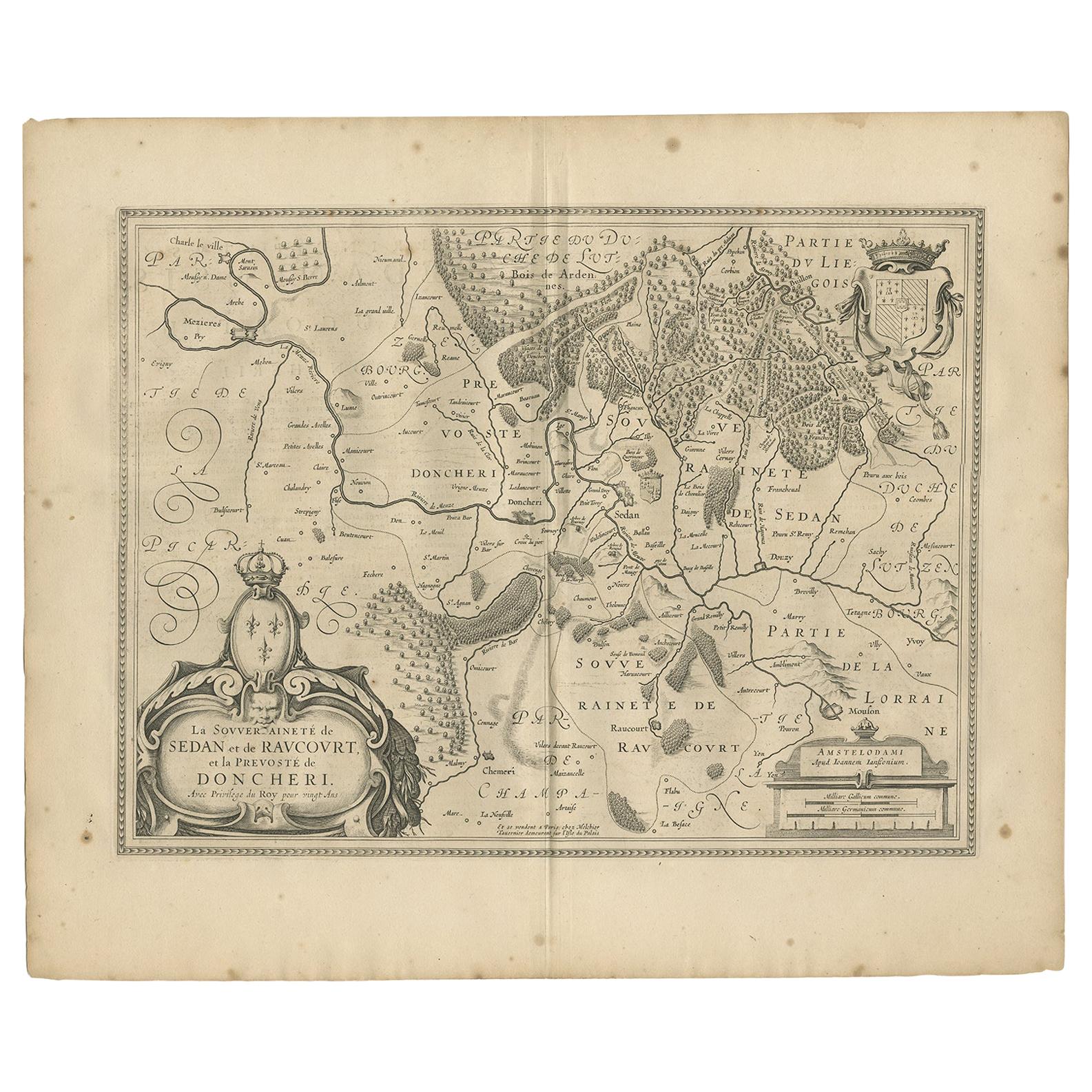
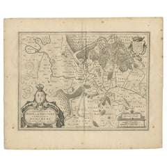
Antique Map of the Region of Sedan and Doncheri by Janssonius, 1657
By Johannes Janssonius
Located in Langweer, NL
Antique map of France titled 'La Souveraineté de Sedan et de Raucourt, et la prevosté de Doncheri'. Lovely map centered on Sedan and Doncheri and the Meuze River from Charleville and...
Category
Antique Mid-17th Century Maps
Materials
Paper
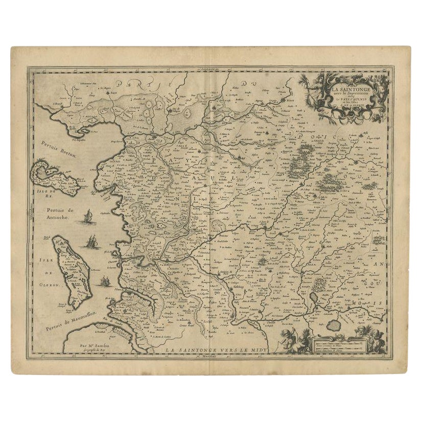
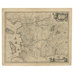
Antique Map of the Region of Saintonge by Janssonius, 1657
By Johannes Janssonius
Located in Langweer, NL
Antique map of France titled 'La Saintonge vers le Septentrion avecq le Pays d'Aulnis'. Decorative map of the Saintonge region. Includes Ile de Re, Ile d'Oleron and the cities of Nio...
Category
Antique 17th Century Maps
Materials
Paper
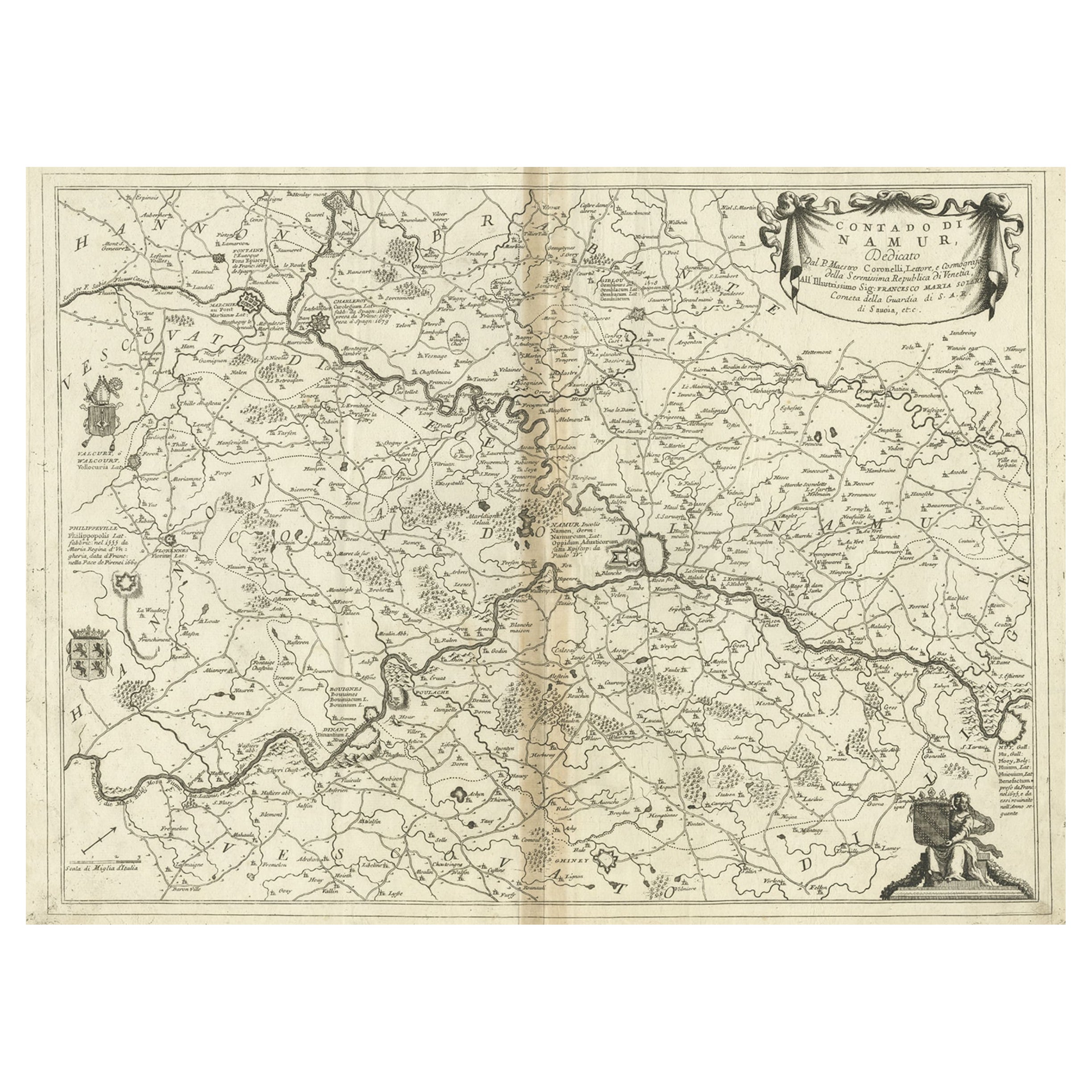
Antique Map of the Namur Region in France by Coronelli, c.1695
By Vincenzo Coronelli
Located in Langweer, NL
Antique map titled 'Contado di Namur (..)'. Old map of the Namur region in central Belgium. Includes several coats of arms.
Artists and Engravers: The remarkable Vincenzo Coronell...
Category
Antique 17th Century Maps
Materials
Paper
Antique Map of Beauce by Janssonius, 1657
By Johannes Janssonius
Located in Langweer, NL
Antique map 'Belsia vulgo la Beausse'. Decorative map of the region of Beauce, a natural region in northern France, located between the Seine and Loire rivers. This map originates fr...
Category
Antique Mid-17th Century Maps
Materials
Paper

You May Also Like
1657 Janssonius Map of Vermandois and Cappelle, Ric. A-004
Located in Norton, MA
1657 Janssonius map of
Vermandois and Cappelle
Ric.a004
Description: Antique map of France titled 'Descriptio Veromanduorum - Gouvernement de la Cappelle'. Two detailed maps o...
Category
Antique 17th Century Unknown Maps
Materials
Paper

1640 Joan Bleau Map Entitled"Diocecese de rheims et le pais de rethel, " Eic.a011
Located in Norton, MA
1640 Joan Bleau map entitled
"Diocecese de rheims et le pais de rethel,"
Ric.a011
OAN BLAEU
Diocecese de Rheims, et le pais de Rethel.
Handcolored engraving, c.1640.
...
Category
Antique 17th Century Dutch Maps
Materials
Paper

1590 Ortelius Map of Calais and Vermandois, France and Vicinity Ric.a014
Located in Norton, MA
1590 Ortelius map of
Calais and Vermandois, France and Vicinity
Ric.a014
Two rare regional Abraham Ortelius maps on a single folio sheet. Left map, entitled Caletensium, depic...
Category
Antique 16th Century Dutch Maps
Materials
Paper

1635 Willem Blaeu Map of Northern France"Comitatvs Bellovacvm" Ric.a08
Located in Norton, MA
1635 Willem Blaeu map of northern France, entitled.
"Comitatvs Bellovacvm Vernacule Beavvais,"
Colored
Ric.a008
“COMITATVS BELLOVACVM…” Amsterdam: W...
Category
Antique 17th Century Unknown Maps
Materials
Paper

1752 Vaugoundy Map of Flanders : Belgium, France, and the Netherlands, Ric.a002
Located in Norton, MA
Large Vaugoundy Map of Flanders:
Belgium, France, and the Netherlands
Colored -1752
Ric.a002
Description: This is a 1752 Didier Robert de Vaugondy map of Flanders. The map de...
Category
Antique 17th Century Unknown Maps
Materials
Paper

1771 Bonne Map of Poitou, Touraine and Anjou, France, Ric.a015
Located in Norton, MA
1771 Bonne Map of Poitou,
Touraine and Anjou, France
Ric.a015
1771 Bonne map of Potiou, Touraine and Anjou entitled "Carte des Gouvernements D'Anjou et du Saumurois, de la Touraine, du Poitou,du Pays d'aunis, Saintonge?Angoumois,"
Carte des gouvernements d'Anjou et du Saumurois, de la Touraine, du Poitou, du Pays d'Aunis, Saintonge-Angoumois. Projettee et assujettie au ciel par M. Bonne, Hyd. du Roi. A Paris, Chez Lattre, rue St. Jacques a la Ville de Bord(ea)ux. Avec priv. du Roi. 1771. Arrivet inv. & sculp., Atlas moderne ou collection de cartes sur toutes...
Category
Antique 17th Century Unknown Maps
Materials
Paper

More Ways To Browse
Antique English Maps
Indonesia Map
Ancient Maps
Antique Mining
Antique Atlas Furniture
Antique Maps Indonesia
Map Of India
China Map
Victorian Furniture 1920
Antique Maps Amsterdam
Antique Maps Of Russia
19th Century Map Of Africa
Map Of Britain
Antique Oregon
Bali Wood
Railroad Furniture
Antique Malaysia
Blaeu Maps