Items Similar to Antique Map of Northern Italy by F. de Wit, 1690

Want more images or videos?
Request additional images or videos from the seller
1 of 5
Antique Map of Northern Italy by F. de Wit, 1690
$524.70
$655.8820% Off
£388.52
£485.6520% Off
€440
€55020% Off
CA$724.73
CA$905.9220% Off
A$776.19
A$970.2420% Off
CHF 417.27
CHF 521.5920% Off
MX$9,427.29
MX$11,784.1220% Off
NOK 5,272.47
NOK 6,590.5920% Off
SEK 4,827.34
SEK 6,034.1720% Off
DKK 3,353.36
DKK 4,191.7020% Off
About the Item
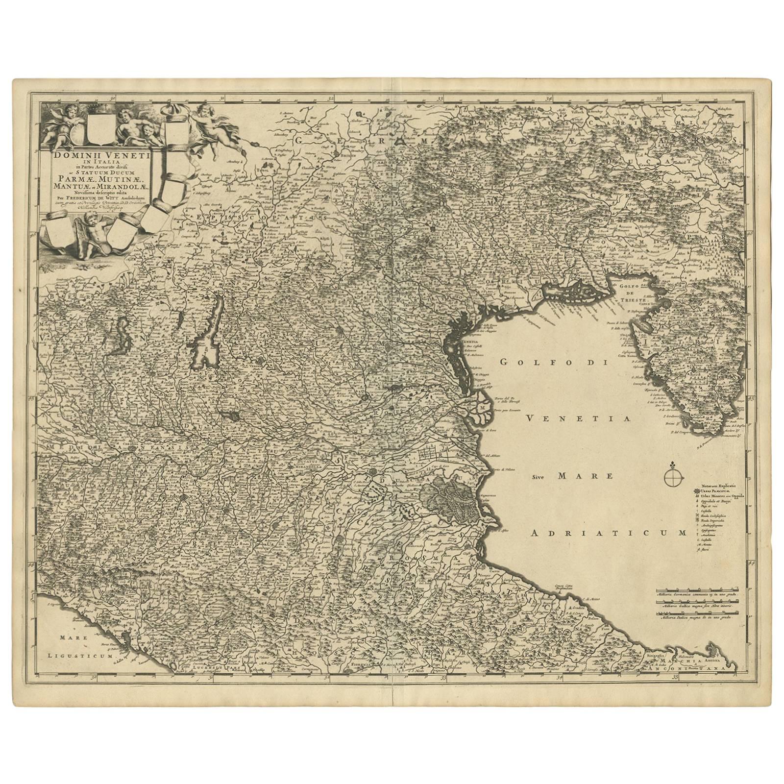
A very decorative map centered on Genua, and including the towns of Milan, Torino, Parma, Cremona, etc. Decorative title cartouche upper right, five putti holding the arms of the regions of the north western part of Italy.
- Dimensions:Height: 20.79 in (52.8 cm)Width: 25.2 in (64 cm)Depth: 0.02 in (0.5 mm)
- Materials and Techniques:
- Period:Late 17th Century
- Date of Manufacture:1690
- Condition:Minor fading. Small tear along folding line. Please study image carefully.
- Seller Location:Langweer, NL
- Reference Number:Seller: BG-091831stDibs: LU305439942631
About the Seller
5.0
Recognized Seller
These prestigious sellers are industry leaders and represent the highest echelon for item quality and design.
Platinum Seller
Premium sellers with a 4.7+ rating and 24-hour response times
Established in 2009
1stDibs seller since 2017
2,826 sales on 1stDibs
Typical response time: 1 hour
- ShippingRetrieving quote...Shipping from: Langweer, Netherlands
- Return Policy
More From This Seller
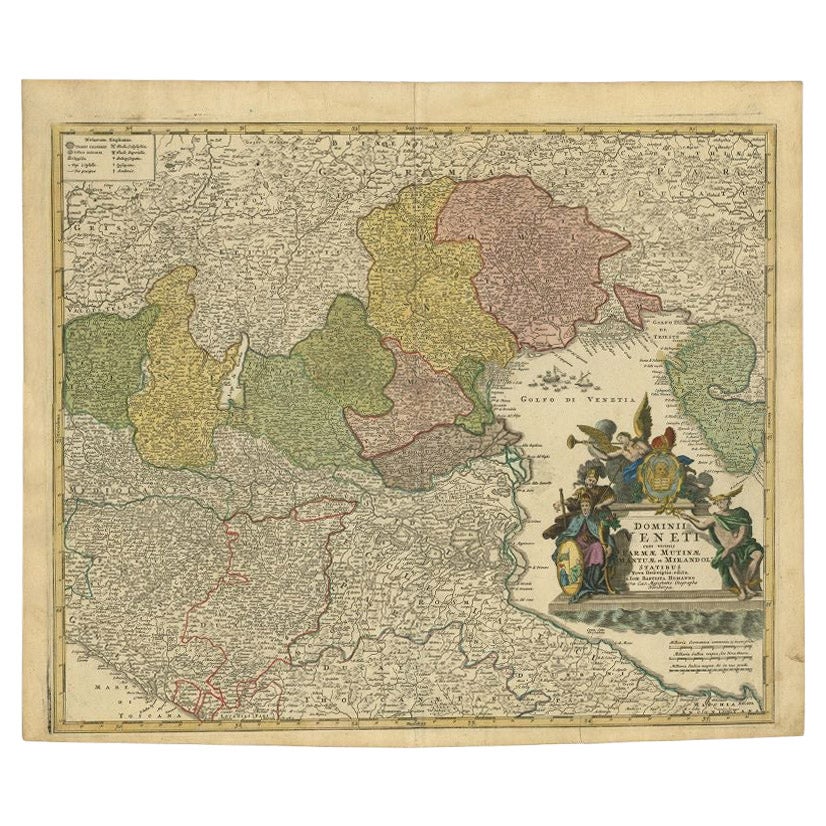
View AllAntique Map of the Region of Venice, Italy by F. De Wit, circa 1700
Located in Langweer, NL
Antique map of the Dominion of Venice, extending from Stato di Milano and Genoa to Istria. Including Lake Garda, Venice and Istria.
Category
Antique Early 18th Century Maps
Materials
Paper
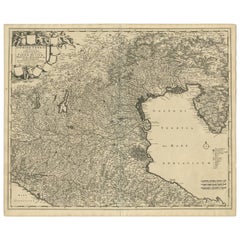
$562 Sale Price
20% Off
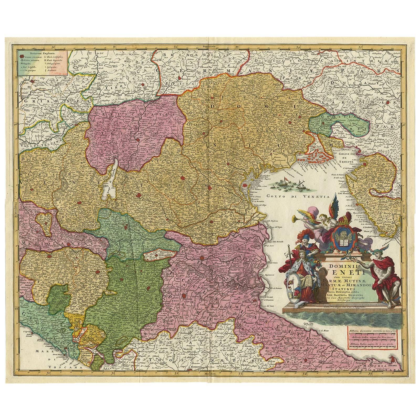
Antique Map of Northern Italy by Homann Heirs, c.1730
Located in Langweer, NL
Antique map titled 'Domini Veneti cum vicinis Parmae Mutinae, Matuae et Mirandol (..).' Detailed map of northern Italy by J. B. Homann. This map shows Venice and its adjacent states ...
Category
Antique 18th Century Maps
Materials
Paper

$496 Sale Price
20% Off
Decorative Antique Map of Austria – Frederick de Wit, Amsterdam c.1690
Located in Langweer, NL
Antique Map of Austria – “Circuli Austriaci pars Septentrionalis” by F. de Wit, c.1670
This finely engraved map, titled “Circuli Austriaci pars Septent...
Category
Antique Late 17th Century Dutch Maps
Materials
Paper

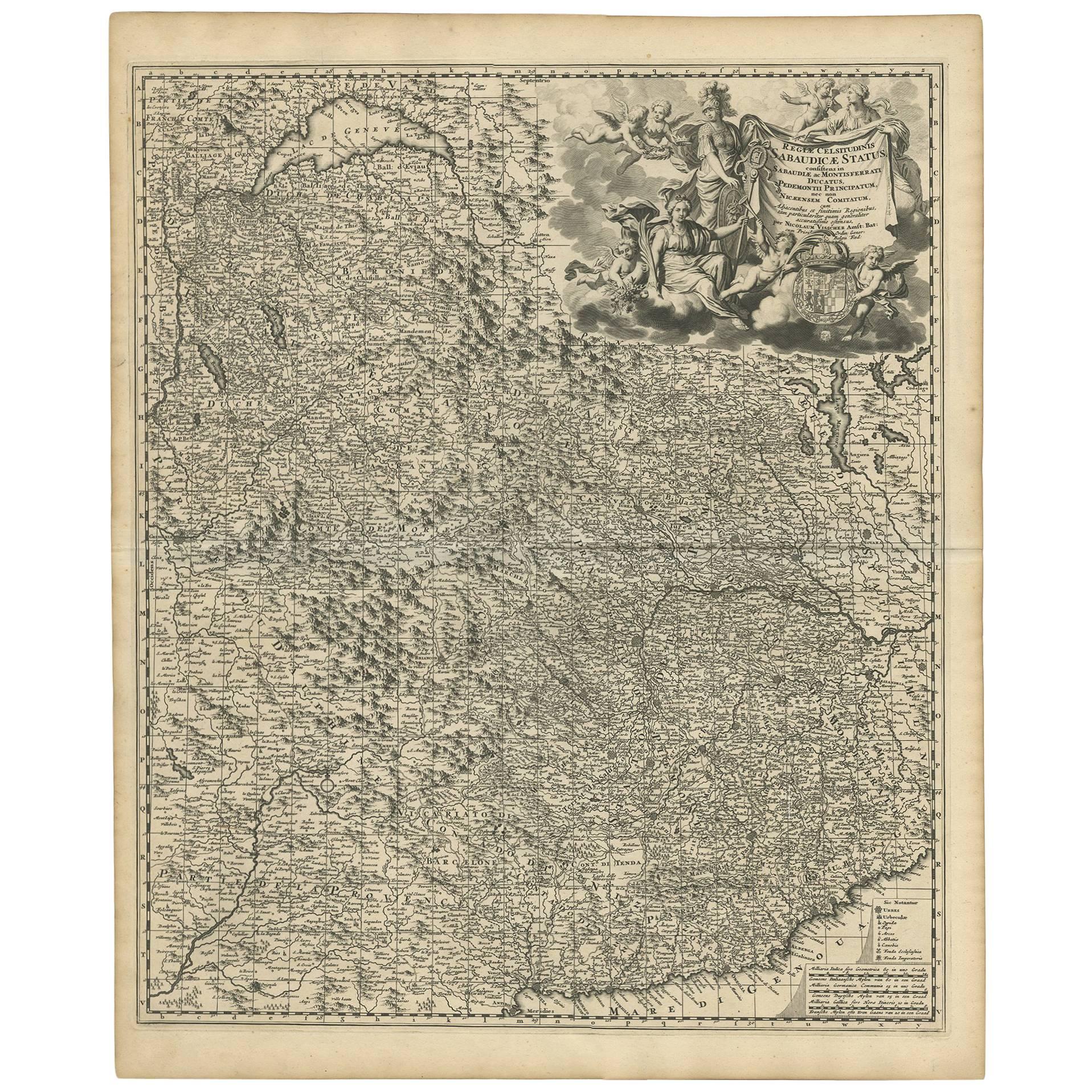
Antique Map of Piedmonte and Savoie
Italy
by N. Visscher, circa 1683
Located in Langweer, NL
Antique map titled 'Regiae Celsitudinis Sabaudicae Status consistens in Sabaudiae ac Montisferrati Ducatus, Pedemontii Principatum (..). This map originates from 'Atlas Minor Sive Ge...
Category
Antique Late 17th Century Dutch Maps
Materials
Paper
$591 Sale Price
20% Off
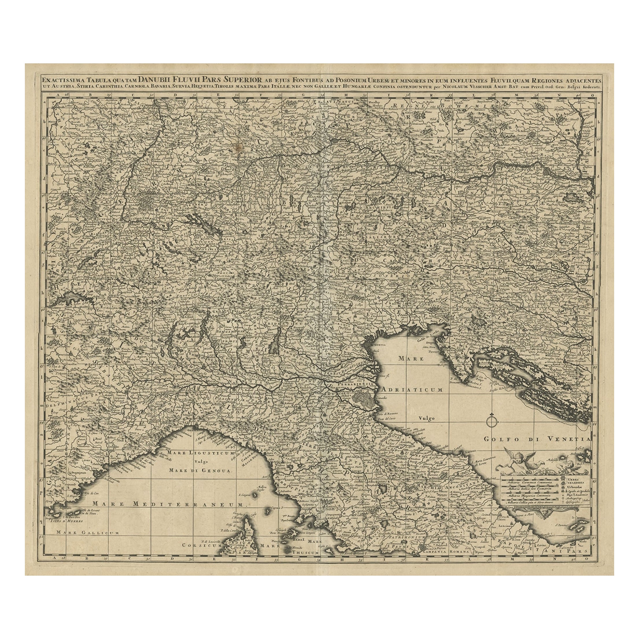
Antique Map Covering Northern Italy, Austria, Slovenia
Croatia, ca.1690
Located in Langweer, NL
Antique map titled 'Exactissima Tabula, qua tam Danubii Fluvii Pars Superior'.
Detailed map covering the region of northern Italy, Austria, Slovenia and Croatia. The course of th...
Category
Antique 1690s Maps
Materials
Paper
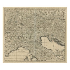
Stunning Antique Map of Northern Italy by J.B. Homann, circa 1745
By Johann Baptist Homann
Located in Langweer, NL
This beautiful hand-colored map covers from Bergamo east as far as Albona (Labin) and from Vipiteno Sterzing south as far as Florence.
The map is exceptionally detailed, noting towns, rivers, lakes, cities and a host of additional topographical features. Includes neighboring Parma, Modena, Mantua and Mirandol. The map depicts the Veneto region and its vicinity during the decline of the Republic of Venice. A key in included in the top left quadrant of the map, while a beautifully engraved title cartouche adorns the lower right quadrant. This map was issued in Homann Heirs circa 1745 edition of Atlas Novus Terrarum Orbis.
Category
Antique Mid-18th Century Maps
Materials
Paper

$621 Sale Price
25% Off
You May Also Like
1640 Willem Blaeu Map Entitled "Contado di molise et principato vltra, " Ric.a003
By Willem Blaeu
Located in Norton, MA
1640 Willem Blaeu map entitled
"Contado di molise et principato vltra,"
Colored
Ric. a003
Measures: 38 x 49.6 cm and wide margins
DBLAEU.
Cou...
Category
Antique 17th Century Dutch Maps
Materials
Paper

17th Century Hand Colored Map of the Liege Region in Belgium by Visscher
By Nicolaes Visscher II
Located in Alamo, CA
An original 17th century map entitled "Leodiensis Episcopatus in omnes Subjacentes Provincias distincté divisusVisscher, Leodiensis Episcopatus" by Nicolaes Visscher II, published in Amsterdam in 1688. The map is centered on Liege, Belgium, includes the area between Antwerp, Turnhout, Roermond, Cologne, Trier and Dinant.
This attractive map is presented in a cream-colored mat measuring 30" wide x 27.5" high. There is a central fold, as issued. There is minimal spotting in the upper margin and a tiny spot in the right lower margin, which are under the mat. The map is otherwise in excellent condition.
The Visscher family were one of the great cartographic families of the 17th century. Begun by Claes Jansz Visscher...
Category
Antique Late 17th Century Dutch Maps
Materials
Paper

17th Century Nicolas Visscher Map of Southeastern Europe
Located in Hamilton, Ontario
A beautiful, highly detailed map of southeastern Europe by Nicolas Visscher. Includes regions of Northern Italy (showing the cities Bologna, Padua, and Venice), Bohemia, Austria (sho...
Category
Antique 17th Century Dutch Maps
Materials
Paper

$1,350 Sale Price
38% Off
18th Century Map of the Southern Balkans by Giovanni Maria Cassini
By Giovanni Maria Cassini
Located in Hamilton, Ontario
18th century map by Italian engraver Giovanni Maria Cassini (Italy 1745-1824).
Map of the Southern Balkans: Rome. Hand colored and copper engraved print done in the year 1788. It in...
Category
Antique 18th Century Italian Maps
Materials
Paper

$795 Sale Price
36% Off
1714 Henri Chatelain "Nouvelle Carte Des Etatas Du Grand.Duc De Mos Moscovie Eur
Located in Norton, MA
A 1714 Henri Chatelain map, entitled
"Nouvelle Carte Des Etatas Du Grand Duc De Moscovie En Europe,"
Ricb001
Henri Abraham Chatelain (1684-1743) was a Huguenot pastor of Parisi...
Category
Antique Early 18th Century Dutch Maps
Materials
Paper

Engraving Depicting 16th Century Map of Terra Sancta
Located in Buchanan, MI
Abraham Ortelius (Flemish, 1527-1598) Terra Sancta.
Engraving depicting 16th century map of Terra Sancta. Site 15" x 19.5.
Category
Antique 18th Century and Earlier Maps
Materials
Paper

More Ways To Browse
Mid Century Modern Corner Chair
Dining Tables With Brass Inlay
Oak Mid Century Armchair
Solid Wood Side Table Stool
Antique Marble Top Hall Table
Old Carpet
Porcelain Modern Hand Painted
Bent Plywood
1960 Italian Dining Set
Italian Giltwood Table
Polished Bronze Table
Antique Laurel Wreath
Armchair In France
Green Oushak
Interlocking Tables
Mid Century Norwegian Furniture
Round Side Table With Glass Top
Vintage Netherlands