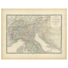
Items Similar to Antique Map of Northern Italy by Migeon, 1880


Want more images or videos?
Request additional images or videos from the seller
1 of 5
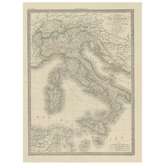
Antique Map of Northern Italy by Migeon, 1880
$100.48
$125.6020% Off
£74.61
£93.2720% Off
€84
€10520% Off
CA$138.06
CA$172.5720% Off
A$150.15
A$187.6920% Off
CHF 79.57
CHF 99.4720% Off
MX$1,799.12
MX$2,248.9020% Off
NOK 1,011.35
NOK 1,264.1920% Off
SEK 926.53
SEK 1,158.1720% Off
DKK 640.42
DKK 800.5320% Off
About the Item
Antique map titled 'Italie Septentrionale'. Old map of the northern part of Italy. This map originates from 'Géographie Universelle Atlas-Migeon' by J. Migeon. Artists and Engravers: Published by J. Migeon. Reviewed by A. Vuillemin. Alexandre Vuillemin (1812-1880) was a cartographer and an book editor based in Paris, France.
Artist: Published by J. Migeon. Reviewed by A. Vuillemin. Alexandre Vuillemin (1812-1880) was a cartographer and an book editor based in Paris, France.
Condition: Good, age-related toning. Please study image carefully.
Date: 1880
Overall size: 47.5 x 34.5 cm.
Image size: 0.001 x 37.5 x 28 cm.
Antique prints have long been appreciated for both their aesthetic and investment value. They were the product of engraved, etched or lithographed plates. These plates were handmade out of wood or metal, which required an incredible level of skill, patience and craftsmanship. Whether you have a house with Victorian furniture or more contemporary decor an old engraving can enhance your living space.
- Dimensions:Height: 13.59 in (34.5 cm)Width: 18.71 in (47.5 cm)Depth: 0 in (0.01 mm)
- Materials and Techniques:
- Period:
- Date of Manufacture:1880
- Condition:
- Seller Location:Langweer, NL
- Reference Number:Seller: BG-11793-141stDibs: LU3054327622492
About the Seller
5.0
Recognized Seller
These prestigious sellers are industry leaders and represent the highest echelon for item quality and design.
Platinum Seller
Premium sellers with a 4.7+ rating and 24-hour response times
Established in 2009
1stDibs seller since 2017
2,823 sales on 1stDibs
Typical response time: 1 hour
- ShippingRetrieving quote...Shipping from: Langweer, Netherlands
- Return Policy
More From This Seller
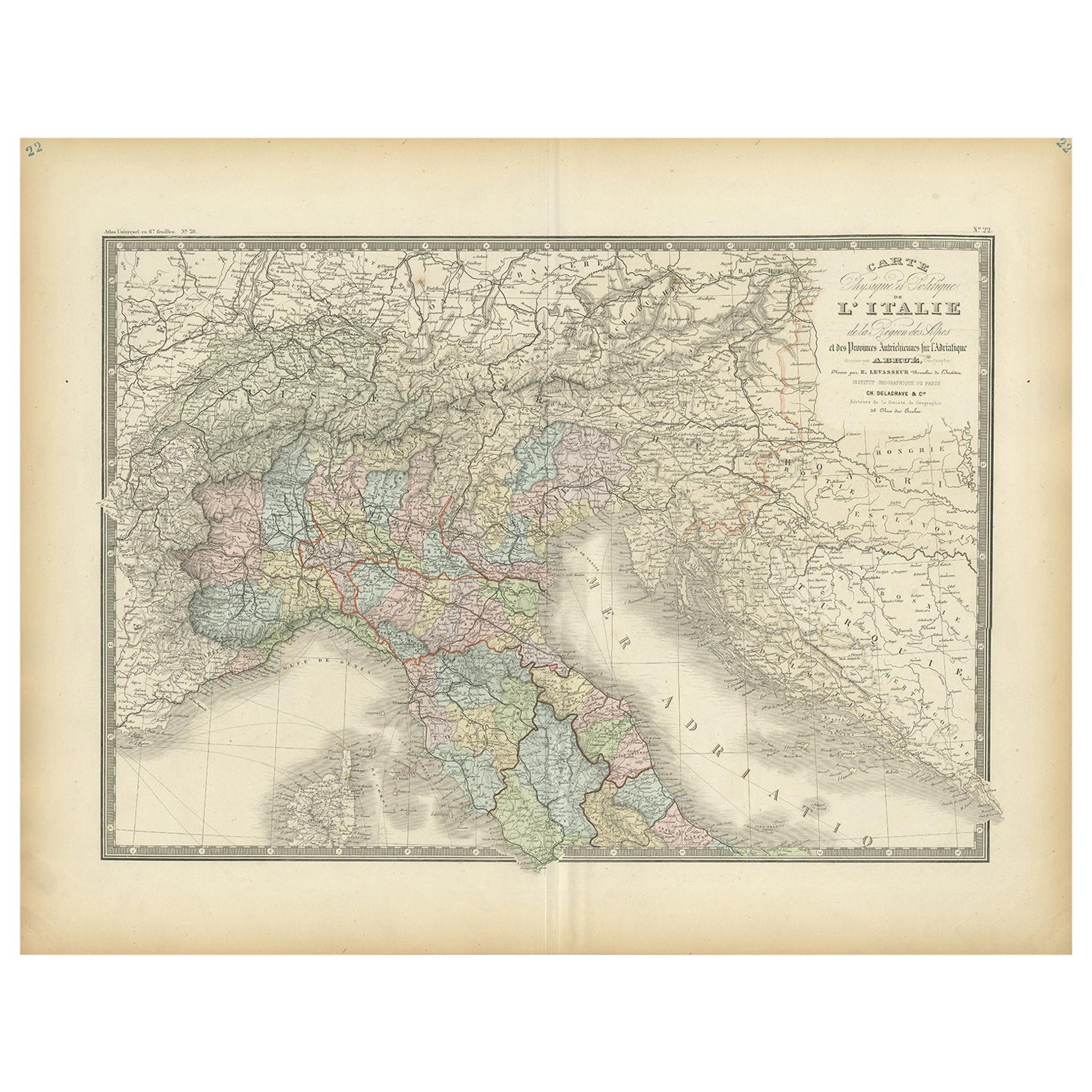
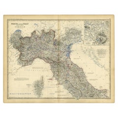
View AllAntique Map of Northern Italy by Levasseur, 1875
Located in Langweer, NL
Antique map titled 'Carte l'Italie (..)'. Large map of Northern Italy. This map originates from 'Atlas de Géographie Moderne Physique et Politique' by A. Levasseur. Published 1875.
Category
Antique Late 19th Century French Maps
Materials
Paper
Antique Map of Northern Italy by J. Tallis, circa 1851
Located in Langweer, NL
A highly decorative mid-19th century map of Northern Italy which was drawn and engraved by John Rapkin (vignettes by A. H. Wray & J. B. Allen) and published in John Tallis & co.'s Th...
Category
Antique Mid-19th Century British Maps
Materials
Paper

Original Antique Map of Italy with an Inset of Sardinia, 1882
Located in Langweer, NL
Embark on a historical odyssey with an original Antique Map of Italy from the esteemed 'Comprehensive Atlas and Geography of the World,' meticulously crafted in 1882. This captivatin...
Category
Antique 1880s Maps
Materials
Paper

$200 Sale Price
20% Off
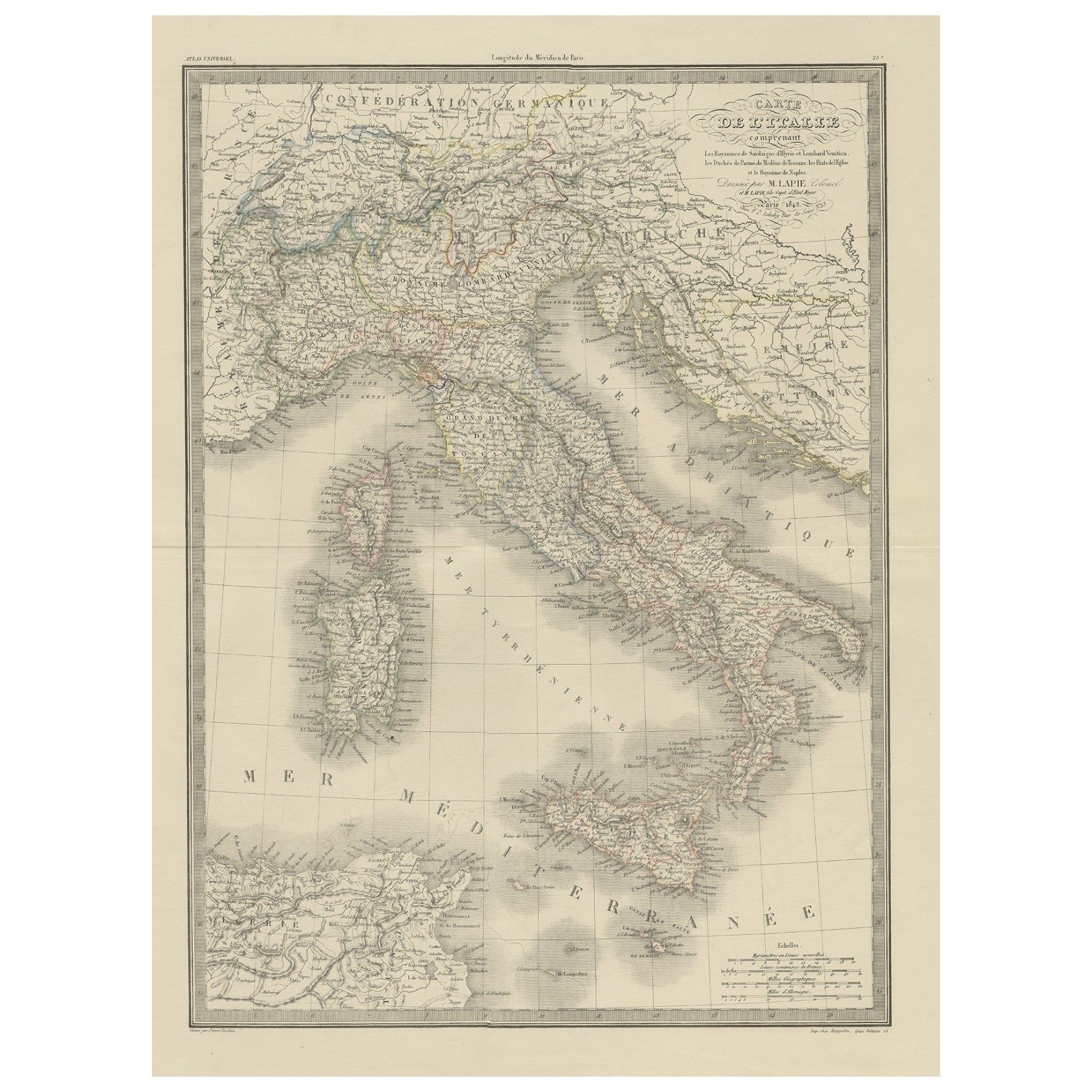
Antique Map of Italy from an Old French Atlas, 1842
Located in Langweer, NL
Antique map titled 'Carte de l'Italie'. Map of Italy.
This map originates from 'Atlas universel de géographie ancienne et moderne (..)' by Pierre M. Lapie and Alexandre E. Lapie. A...
Category
Antique 19th Century French Maps
Materials
Paper
Antique Map of Italy by Pierre M. Lapie, Paper Print, Mid-19th Century
Located in Langweer, NL
Antique map titled 'Carte de l'Italie Ancienne'. Map of Italy. This map originates from 'Atlas universel de géographie ancienne et moderne (..)' by Pierre...
Category
Antique Mid-19th Century French Maps
Materials
Paper

$478 Sale Price
20% Off
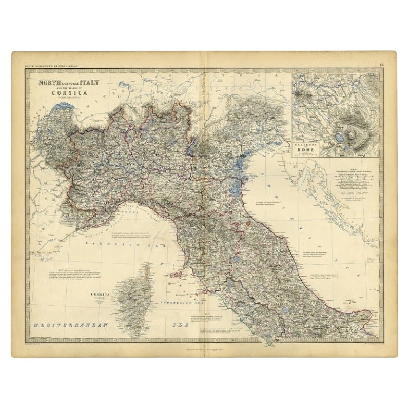
Antique Map of Italy and Corsica, c.1860
Located in Langweer, NL
Antique map titled 'North & Central Italy and the Island of Corsica'.
Old map of North and Central Italy, and the island of Corsica. With an inset map of the region of Rome. Orig...
Category
Antique 19th Century Maps
Materials
Paper
You May Also Like
Large Original Antique Map of Italy. John Dower, 1861
Located in St Annes, Lancashire
Great map of Italy
Lithograph engraving by John Dower
Original colour
Published, 1861
Unframed
Good condition / repair to top right corner seen in last image
Category
Antique 1860s English Victorian Maps
Materials
Paper

Italy, Northern Part. Century Atlas antique vintage map
Located in Melbourne, Victoria
'The Century Atlas. Italy, Northern Part.'
Original antique map, 1903.
Central fold as issued. Map name and number printed on the reverse corners.
Sheet 29.5cm by 40cm.
Category
Early 20th Century Victorian More Prints
Materials
Lithograph

Large Original Antique Map of The South of Italy. John Dower, 1861
Located in St Annes, Lancashire
Great map of the South of Italy
Lithograph engraving by John Dower
Original colour
Published, 1861
Unframed
Good condition
Free shipping
Category
Antique 1860s English Victorian Maps
Materials
Paper

Italy, Central and Southern Part. Century Atlas antique map
Located in Melbourne, Victoria
'The Century Atlas. Italy, Central and Southern Part.'
Original antique map, 1903.
Inset maps of Sicily and Naples.
Central fold as issued. Map name an...
Category
Early 20th Century Victorian More Prints
Materials
Lithograph

Map of the Republic of Genoa
Located in New York, NY
Framed antique hand-coloured map of the Republic of Genoa including the duchies of Mantua, Modena, and Parma.
Europe, late 18th century.
Dimension: 25...
Category
Antique Late 18th Century European Maps

Geographical Map of Italy
Located in Alessandria, Piemonte
BOLIS Publishing House - Bergamo.
A beautiful large map of Italy, on paper but suitably reinforced to preserve it correctly. The maps were usually p...
Category
Mid-20th Century Italian Other Prints
Materials
Paper

More Ways To Browse
Ptolemy Map
Antique Maps Massachusetts
Antique Maps Singapore
Antique Planisphere
Map Of Palestine
R Johnston
Santa Cruz Island
Shetland Map
Antique Alabama Map
Antique Framed Map Engravings
Antique Furniture Cheshire
Antique Great Lakes Map
Antique Map Of Michigan
Antique Map Of Turkish Empire
Antique Map Of Yorkshire
Bali Map
Bermuda Map
British Empire Map