Items Similar to Antique Map of Nottinghamshire by Speed, 1676


Want more images or videos?
Request additional images or videos from the seller
1 of 5
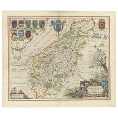
Antique Map of Nottinghamshire by Speed, 1676
$464.18
$580.2320% Off
£346.53
£433.1720% Off
€391.20
€48920% Off
CA$644.89
CA$806.1120% Off
A$693.67
A$867.0920% Off
CHF 370.72
CHF 463.4020% Off
MX$8,176.38
MX$10,220.4820% Off
NOK 4,673.87
NOK 5,842.3420% Off
SEK 4,272.81
SEK 5,341.0120% Off
DKK 2,981.38
DKK 3,726.7320% Off
About the Item
Antique map titled 'The Countie of Nottingham (..)'. Map of Nottinghamshire, England. Includes an inset town plan of Nottingham. This map originates from 'Theatre of Great Britaine' by John Speed. Artists and Engravers: John Speed (1551 or 1552 - 28 July 1629) was an English cartographer and historian. He is, alongside Christopher Saxton, one of the best known English mapmakers of the early modern period.
Artist: John Speed (1551 or 1552 ? 28 July 1629) was an English cartographer and historian. He is, alongside Christopher Saxton, one of the best known English mapmakers of the early modern period.
Condition: Fair, strong toning. Small split on folding line. Minor wear and soiling, English text on verso. Please study image carefully.
Date: 1676
Overall size: 54 x 42.5 cm.
Image size: 0.001 x 51 x 38.5 cm.
Antique prints have long been appreciated for both their aesthetic and investment value. They were the product of engraved, etched or lithographed plates. These plates were handmade out of wood or metal, which required an incredible level of skill, patience and craftsmanship. Whether you have a house with Victorian furniture or more contemporary decor an old engraving can enhance your living space. We offer a wide range of authentic antique prints for any budget.
- Dimensions:Height: 16.74 in (42.5 cm)Width: 21.26 in (54 cm)Depth: 0 in (0.01 mm)
- Materials and Techniques:
- Period:
- Date of Manufacture:1676
- Condition:
- Seller Location:Langweer, NL
- Reference Number:Seller: BG-12705-61stDibs: LU3054327616382
About the Seller
5.0
Recognized Seller
These prestigious sellers are industry leaders and represent the highest echelon for item quality and design.
Platinum Seller
Premium sellers with a 4.7+ rating and 24-hour response times
Established in 2009
1stDibs seller since 2017
2,836 sales on 1stDibs
Typical response time: 1 hour
- ShippingRetrieving quote...Shipping from: Langweer, Netherlands
- Return Policy
More From This Seller
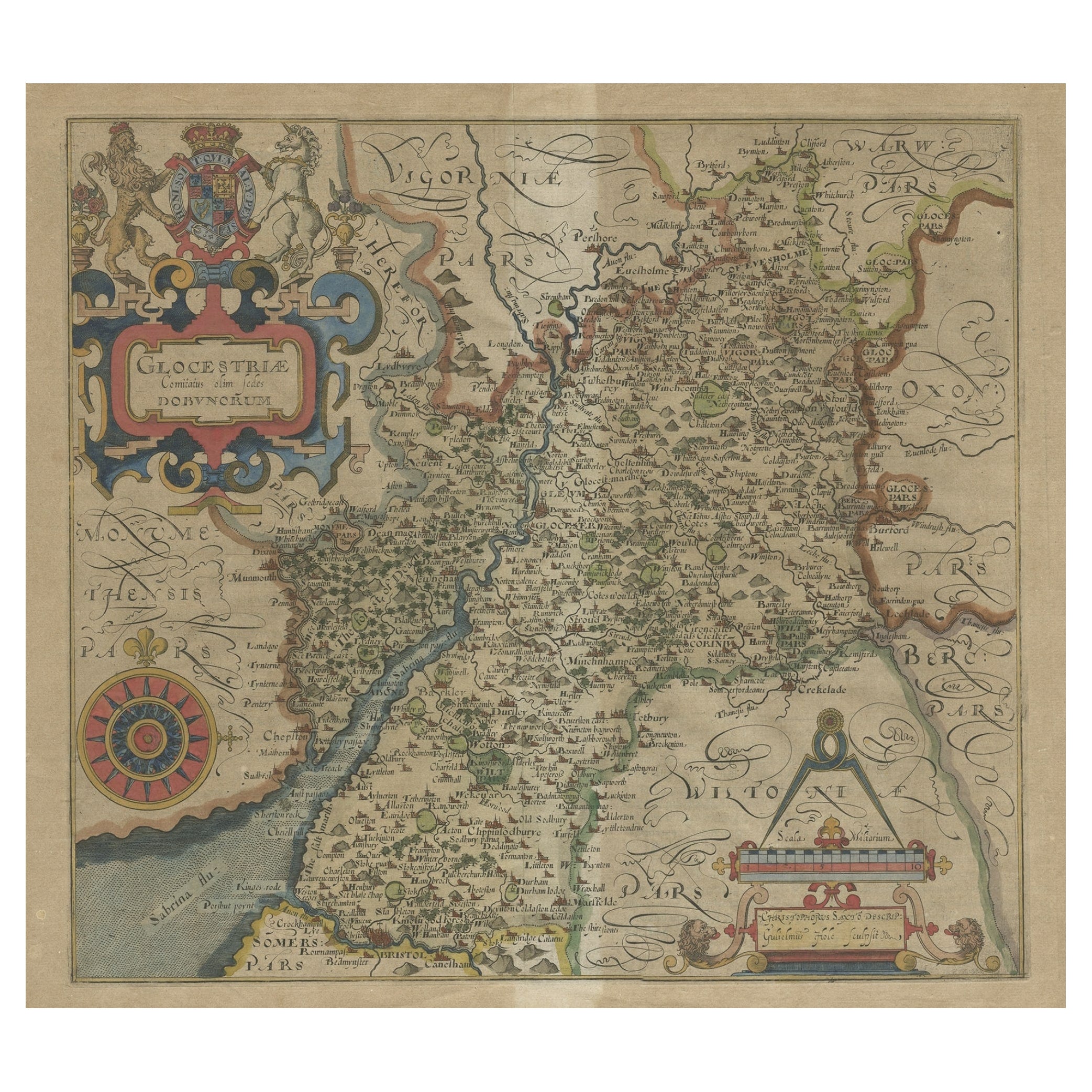
View AllAntique Map of Gloucestershire by Camden, c.1607
Located in Langweer, NL
Antique map titled 'Glocestriae comitatus olim sedes Dobunorum'. Map of Gloucestershire, England. This map originates from Camden?s 'Britannia' ...
Category
Antique 17th Century Maps
Materials
Paper

Antique Map of Hertfordshire in England by Speed, 1627
Located in Langweer, NL
Antique map titled 'Hartfordshire described the sittuations of Hartford (..)'.
Map of Hertfordshire, England. Includes inset maps of Hertford and the Roman settlement of Verolani...
Category
Antique 17th Century Maps
Materials
Paper

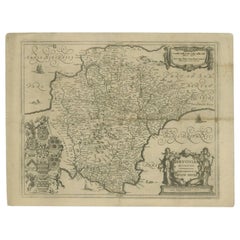
Antique Map of Northamptonshire by Speed, 1676
Located in Langweer, NL
Antique map titled 'Norhamtonshire'. Map of Norhamptonshire, England. Includes inset town plans of Peterborough and Northampton. This map originates from 'Theatre of Great Britaine' ...
Category
Antique 17th Century Maps
Materials
Paper

$522 Sale Price
20% Off
Antique Map of Buckinghamshire in England, 1743
Located in Langweer, NL
Antique map titled 'Buckingham both shyre and shire towne describ'. Map of Buckinghamshire, England. With town plans of Buckingham and Redding. This map originates from Overton's atl...
Category
Antique 18th Century Maps
Materials
Paper

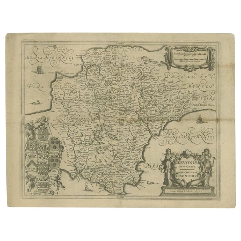
Antique Map of the County of Devon by Overton, 1713
Located in Langweer, NL
Antique map titled 'Devoniae Descriptio - The Description of Devon Shire'. Map of the County of Devon, England. This map originates from the 1713 edition of the 'Overton Atlas'. Henry Overton only revised the Devon map...
Category
Antique 18th Century Maps
Materials
Paper
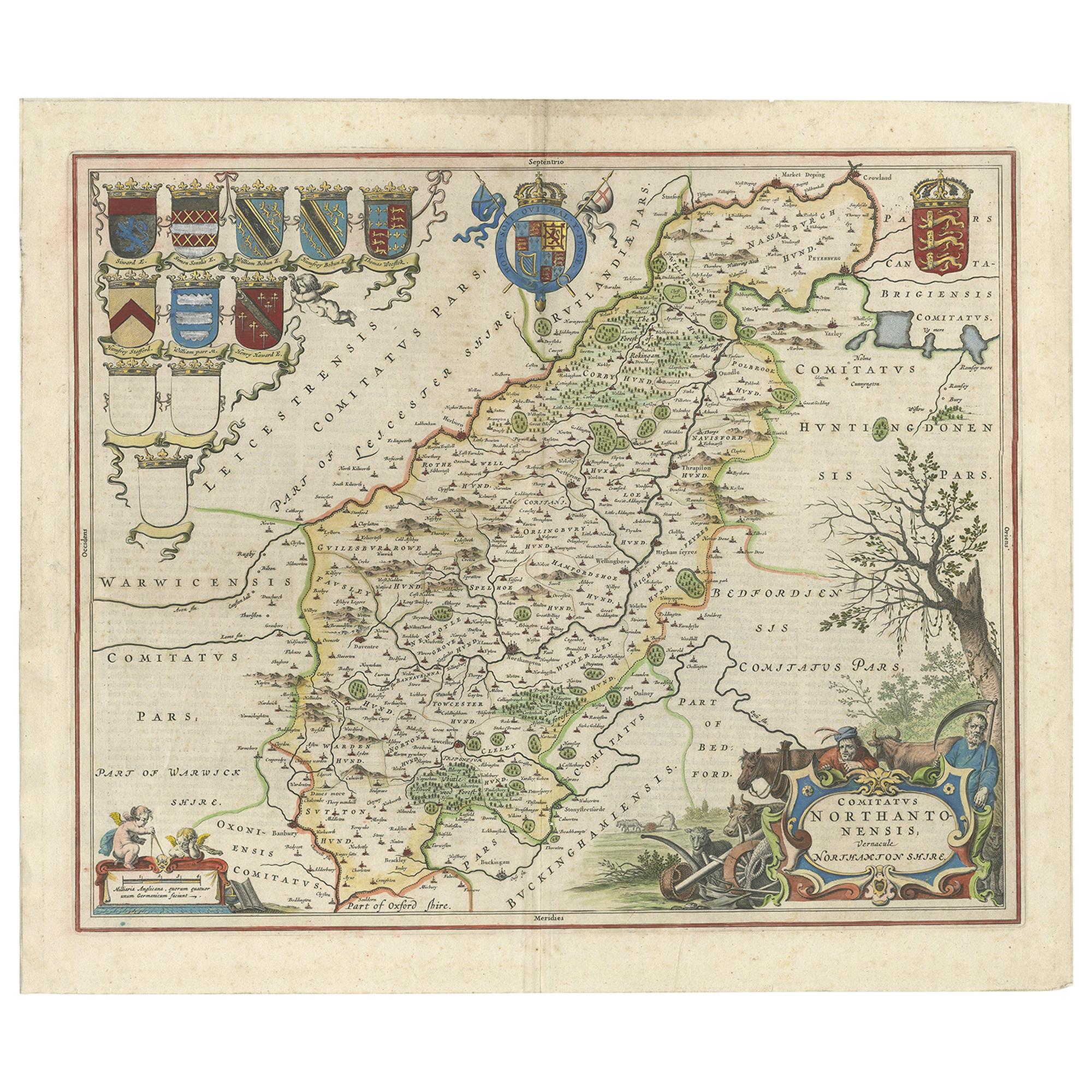
A Gold Highlighted Antique Map of Northamptonshire by Blaeu
1659
Located in Langweer, NL
Antique map titled 'Comitatus Northantonensis vernacule Northamtonshire'. Original antique map of Northamptonshire, England. This map originates from 'Atlas Universal y Cosmographico...
Category
Antique Mid-17th Century Dutch Maps
Materials
Paper
$759 Sale Price
20% Off
You May Also Like
Antique Stafford County Map, English, Atlas Engraving, 17th Century, Cartography
Located in Hele, Devon, GB
This is an antique Stafford County Map. An English, framed atlas engraving of Staffordshire, dating to the 17th century and later, circa 1676.
Superb cartography reproduction of St...
Category
Antique Late 17th Century British Charles II Maps
Materials
Glass, Paper
Antique Road Map, London to Hythe, Kent, English, Cartography, John Ogilby, 1675
Located in Hele, Devon, GB
This is an antique Road Map from London to Hythe, Kent. An English, cartographic atlas excerpt by John Ogilby, dating to the late 17th century with later frame, circa 1675
A superb ...
Category
Antique 17th Century British Queen Anne Maps
Materials
Glass, Paper
Antique Suffolk County Map, Dutch, Atlas Novus, Joan Blaeu, Cartography, C.1645
Located in Hele, Devon, GB
This is an antique county map of Suffolk. A Dutch, framed atlas engraving by Joan Blaeu, dating to the 17th century and later.
A treat for the collector or county native, with this ...
Category
Antique 1640s Dutch Charles II Maps
Materials
Glass, Paper
1635 Willem Blaeu Map of Northern France"Comitatvs Bellovacvm" Ric.a08
Located in Norton, MA
1635 Willem Blaeu map of northern France, entitled.
"Comitatvs Bellovacvm Vernacule Beavvais,"
Colored
Ric.a008
“COMITATVS BELLOVACVM…” Amsterdam: W...
Category
Antique 17th Century Unknown Maps
Materials
Paper

1640 Joan Bleau Map Entitled"Diocecese de rheims et le pais de rethel, " Eic.a011
Located in Norton, MA
1640 Joan Bleau map entitled
"Diocecese de rheims et le pais de rethel,"
Ric.a011
OAN BLAEU
Diocecese de Rheims, et le pais de Rethel.
Handcolored engraving, c.1640.
...
Category
Antique 17th Century Dutch Maps
Materials
Paper

1657 Janssonius Map of Vermandois and Cappelle, Ric. A-004
Located in Norton, MA
1657 Janssonius map of
Vermandois and Cappelle
Ric.a004
Description: Antique map of France titled 'Descriptio Veromanduorum - Gouvernement de la Cappelle'. Two detailed maps o...
Category
Antique 17th Century Unknown Maps
Materials
Paper

More Ways To Browse
Map Of Native American Tribes
Old Spice
Romania Map
Used Furniture Nova Scotia
18th Century Scottish Collectibles
Antique Furniture Northumberland
Antique Map Nova Scotia
Antique Map Palestine
California Island Map
Constantinople Map
Croatian Antiques
Jamaican Antique
Large Map Of Italy
Louisiana Antiques
Maps South East Asia
New Jersey Antique Furniture
Ptolemy Map
Antique Maps Massachusetts