Items Similar to Antique Map of Oostergo, Friesland by von Reilly, 1791


Want more images or videos?
Request additional images or videos from the seller
1 of 10
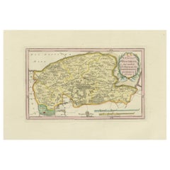
Antique Map of Oostergo, Friesland by von Reilly, 1791
$468.74
£347.21
€390
CA$641.22
A$698.90
CHF 369.50
MX$8,413.41
NOK 4,689.90
SEK 4,299.68
DKK 2,971.58
About the Item
Antique Map of Oostergo, Friesland by von Reilly, 1791
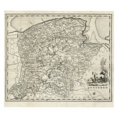
Original engraved map titled 'Oostergo No. 643', published in Vienna in 1791. This map depicts the historic region of Oostergo in Friesland, bounded by the Lauwerszee to the north and the Groningen border to the east. It shows in fine detail the rural districts (grietenijen), towns, villages, and waterways that defined the region at the end of the 18th century.
The map highlights Dokkum, the old fortified town famous as the place where Saint Boniface was martyred in 754. Other important places marked include Kollum, Buitenpost, Ferwerd, Holwerd, Ee, Metslawier, Anjum, Engwierum, Oostrum, Jislum, Ternaard, and Wierum. The southern part of the map shows the approach to Leeuwarden, the provincial capital. District boundaries are outlined in original hand color, with a simple but elegant decorative cartouche in the lower right corner.
The engraving was produced for Franz Joseph Johann von Reilly’s Schauplatz der fünf Theile der Welt (“Showplace of the Five Parts of the World”), one of the first comprehensive Austrian atlas projects. Von Reilly (1766–1820), a Viennese publisher and art dealer, sought to bring together accurate geography with appealing design. The plate was engraved by Ignaz Alberti (1760–1794), whose fine linework gave clarity and elegance to the series.
This map offers a fascinating record of Friesland’s northeastern territories, rich in waterways and agricultural land. It is particularly valuable to collectors interested in Frisian history, Dutch provincial cartography, and Austrian atlas production of the late Enlightenment period.
Condition report: Very good condition with light age toning. Small marginal water stain at lower right, outside the printed area. Original hand coloring intact. Blank verso.
Framing tips: A gilt or dark wooden frame with a cream or ivory mat will highlight the fine detail and subtle hand coloring. For added depth, a thin green or ochre inner line in the mount can echo the tones of the map and cartouche.
Technique: Engraving with original hand color
Maker: Franz Joseph Johann von Reilly, engraved by Ignaz Alberti, Vienna, 1791
- Dimensions:Height: 13.39 in (34 cm)Width: 20.08 in (51 cm)Depth: 0.01 in (0.2 mm)
- Materials and Techniques:Paper,Engraved
- Place of Origin:
- Period:
- Date of Manufacture:1791
- Condition:Condition report: Very good condition with light age toning. Small marginal water stain at lower right, outside the printed area. Original hand coloring intact. Blank verso.
- Seller Location:Langweer, NL
- Reference Number:Seller: BG-13229-171stDibs: LU3054346690472
About the Seller
5.0
Recognized Seller
These prestigious sellers are industry leaders and represent the highest echelon for item quality and design.
Platinum Seller
Premium sellers with a 4.7+ rating and 24-hour response times
Established in 2009
1stDibs seller since 2017
2,813 sales on 1stDibs
Typical response time: 1 hour
- ShippingRetrieving quote...Shipping from: Langweer, Netherlands
- Return Policy
More From This Seller
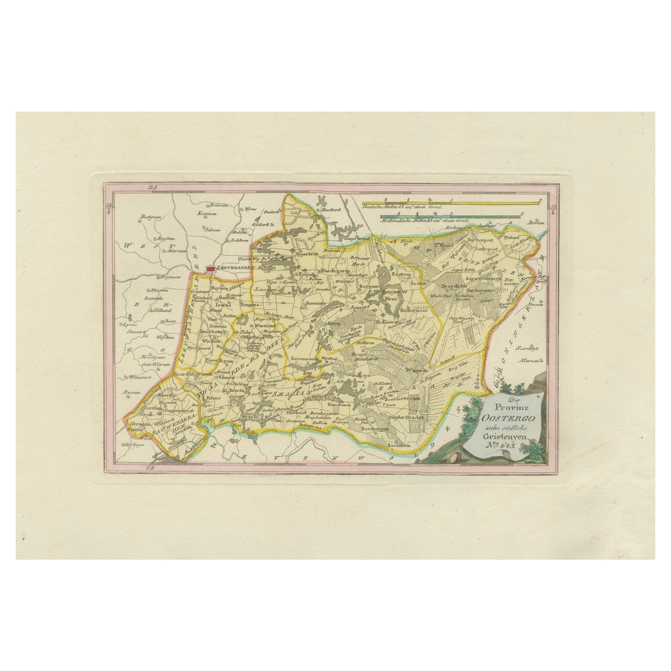
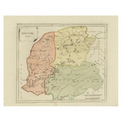
View AllAntique Map of Eastern Oostergo, Friesland by von Reilly, 1791
Located in Langweer, NL
Antique Map of Eastern Oostergo, Friesland by von Reilly, 1791
Original engraved map titled Der Provinz Oostergo sechs östliche Grietenyen No. 643, published in Vienna in 1791. This...
Category
Antique 18th Century Austrian Maps
Materials
Paper
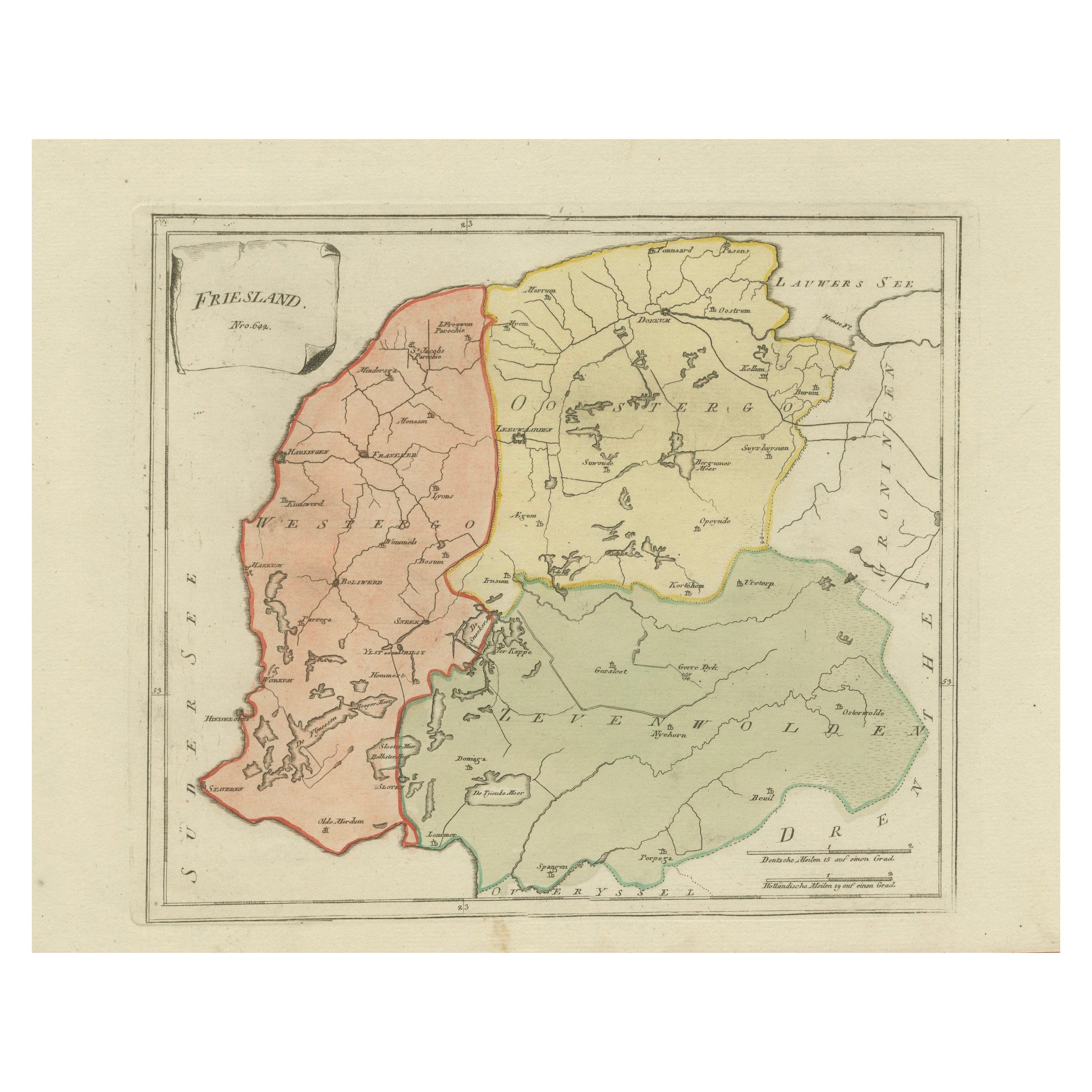
Antique Map of Friesland by Von Reilly, 1791
Located in Langweer, NL
Antique map titled 'Friesland'. Map of the province of Friesland, the Netherlands. This map orginates from 'Schauplatz der fünf Theile der Welt'. Artists and Engravers: Franz Joseph ...
Category
Antique 18th Century Austrian Maps
Materials
Paper

Antique Map of Southern Westergo, Friesland by von Reilly, 1791
Located in Langweer, NL
Antique Map of Southern Westergo, Friesland by von Reilly, 1791
Original engraved map titled Westergoo Norde, published in Vienna in 1791. This sheet depicts the southern and coasta...
Category
Antique 18th Century Austrian Maps
Materials
Paper
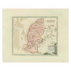
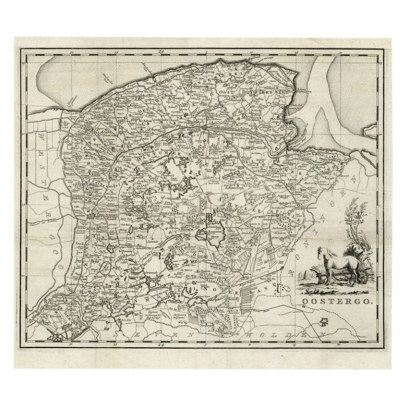
Antique Map of Oostergo, Friesland by Tirion, 1785
Located in Langweer, NL
Antique map Friesland titled 'Oostergo'. Antique map of part of Friesland depicting the 'Oostergo' region. Decorative titled cartouche with horse and plough. Originates from 'Tegenwo...
Category
Antique 18th Century Maps
Materials
Paper
$180 Sale Price
20% Off
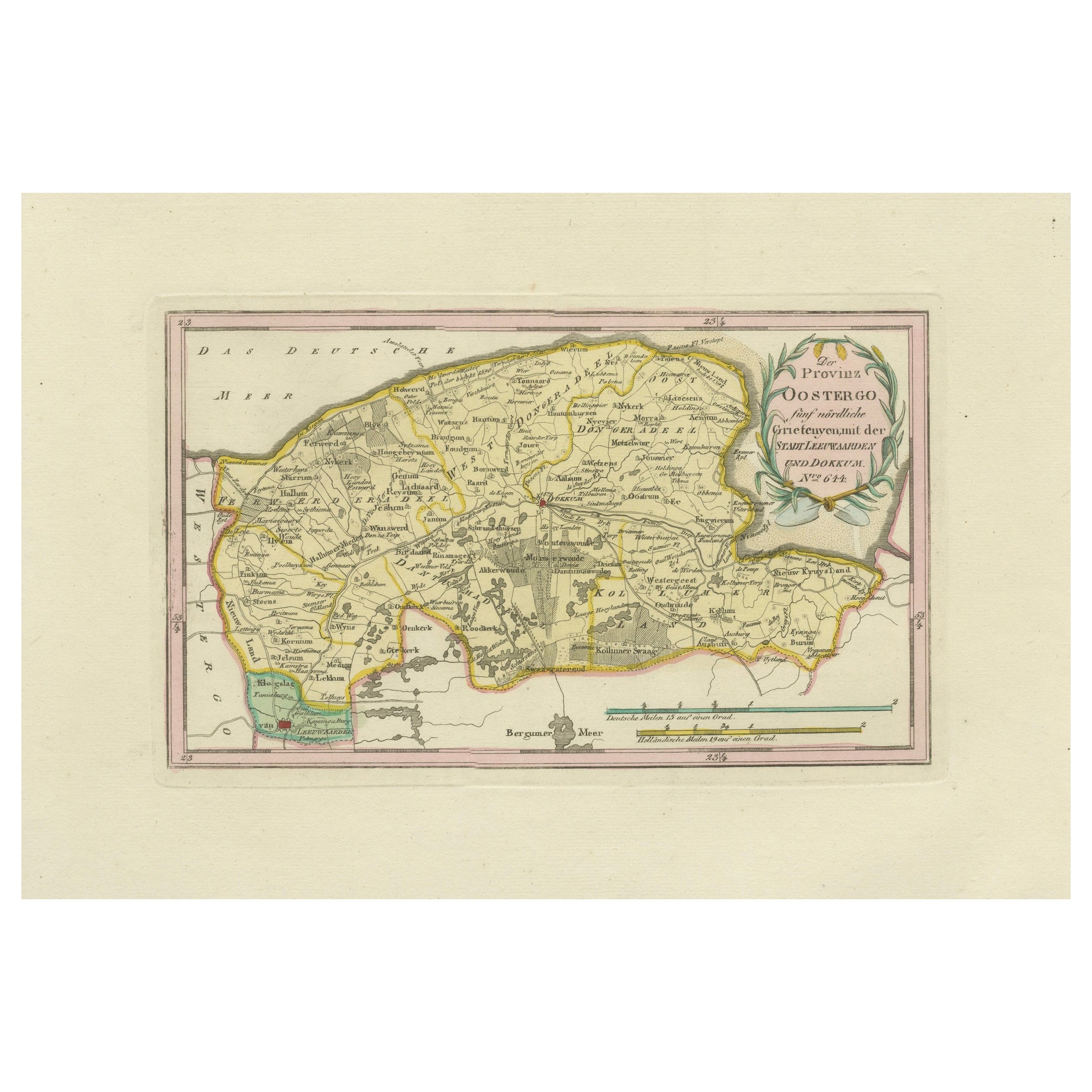
Antique Map of Leeuwarden and Dokkum, Friesland by von Reilly, 1791
Located in Langweer, NL
Antique Map of Leeuwarden and Dokkum, Friesland by von Reilly, 1791
Original engraved map titled Der Provinz Oostergo fünf nördliche Grietenyen, mit der Stadt Leeuwarden und Dokkum ...
Category
Antique 18th Century Austrian Maps
Materials
Paper
Antique General Map of Friesland – Dutch Provincial Map by von Reilly, 1791
Located in Langweer, NL
Antique General Map of Friesland by von Reilly, 1791
Original engraved map titled Friesland No. 640, published in Vienna in 1791. This sheet is the general overview of the province ...
Category
Antique 18th Century Austrian Maps
Materials
Paper
You May Also Like
1752 Vaugoundy Map of Flanders : Belgium, France, and the Netherlands, Ric.a002
Located in Norton, MA
Large Vaugoundy Map of Flanders:
Belgium, France, and the Netherlands
Colored -1752
Ric.a002
Description: This is a 1752 Didier Robert de Vaugondy map of Flanders. The map de...
Category
Antique 17th Century Unknown Maps
Materials
Paper

1635 Willem Blaeu Map of Northern France"Comitatvs Bellovacvm" Ric.a08
Located in Norton, MA
1635 Willem Blaeu map of northern France, entitled.
"Comitatvs Bellovacvm Vernacule Beavvais,"
Colored
Ric.a008
“COMITATVS BELLOVACVM…” Amsterdam: W...
Category
Antique 17th Century Unknown Maps
Materials
Paper

1771 Bonne Map of Poitou, Touraine and Anjou, France, Ric.a015
Located in Norton, MA
1771 Bonne Map of Poitou,
Touraine and Anjou, France
Ric.a015
1771 Bonne map of Potiou, Touraine and Anjou entitled "Carte des Gouvernements D'Anjou et du Saumurois, de la Touraine, du Poitou,du Pays d'aunis, Saintonge?Angoumois,"
Carte des gouvernements d'Anjou et du Saumurois, de la Touraine, du Poitou, du Pays d'Aunis, Saintonge-Angoumois. Projettee et assujettie au ciel par M. Bonne, Hyd. du Roi. A Paris, Chez Lattre, rue St. Jacques a la Ville de Bord(ea)ux. Avec priv. du Roi. 1771. Arrivet inv. & sculp., Atlas moderne ou collection de cartes sur toutes...
Category
Antique 17th Century Unknown Maps
Materials
Paper

1643 Willem&Joan Blaeu Map NW Flanders "Flandriae Teutonicae Pars Prientalior
Located in Norton, MA
1643 Willem and Joan Blaeu map of northwest Flanders, entitled
"Flandriae Teutonicae Pars Prientalior,"
Ric0012
" Authentic" - Map of the northwest Fl...
Category
Antique 17th Century Dutch Maps
Materials
Paper

18th Century Emanuel Bowen Map of County of York, c.1740
By Emanuel Bowen
Located in Royal Tunbridge Wells, Kent
Antique 18th century British rare and original Emanuel Bowen (1694-1767) map of the County of York divided into its Ridings and subdivided into wapontakes, mounted in solid wood fram...
Category
Antique Early 18th Century British Maps
Materials
Paper

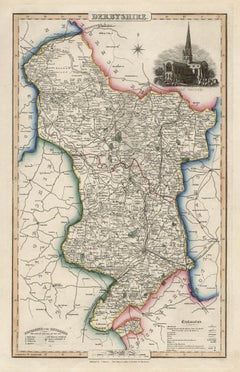
Derbyshire, English County Antique map, 1847
By Isaac Slater
Located in Melbourne, Victoria
Steel-engraved map with original outline colouring by Isaac Slater. A detailed engraved map of the English county with title, scale, and key. Decorated with an uncoloured engraved vi...
Category
19th Century Naturalistic Landscape Prints
Materials
Engraving