Items Similar to Antique Map of Ooststellingwerf by Kuyper, 1868

Want more images or videos?
Request additional images or videos from the seller
1 of 5
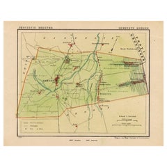
Antique Map of Ooststellingwerf by Kuyper, 1868
$119.14
$148.9220% Off
£88.51
£110.6420% Off
€100
€12520% Off
CA$165.19
CA$206.4920% Off
A$177.65
A$222.0620% Off
CHF 94.99
CHF 118.7420% Off
MX$2,142.41
MX$2,678.0120% Off
NOK 1,201.21
NOK 1,501.5120% Off
SEK 1,094.46
SEK 1,368.0720% Off
DKK 762.17
DKK 952.7120% Off
About the Item
Antique map titled 'Provincie Friesland - Gemeente Oost-Stellingwerf'. Map of the township of Ooststellingwerf including Makkinga, Oosterwolde and many other villages. This map originates from 'Gemeente-Atlas van Nederland' by J. Kuyper. Artists and Engravers: Published by H. Suringar.
Artist: Published by H. Suringar.
Condition: Good, passe-partout/matting included. Top left sl. bumped. General age-related toning, minor wear. Please study image carefully.
Date: 1868
Overall size: 29.5 x 27 cm.
Antique prints have long been appreciated for both their aesthetic and investment value. They were the product of engraved, etched or lithographed plates. These plates were handmade out of wood or metal, which required an incredible level of skill, patience and craftsmanship. Whether you have a house with Victorian furniture or more contemporary decor an old engraving can enhance your living space. We offer a wide range of authentic antique prints for any budget.
- Dimensions:Height: 10.63 in (27 cm)Width: 11.62 in (29.5 cm)Depth: 0 in (0.01 mm)
- Materials and Techniques:
- Period:
- Date of Manufacture:1868
- Condition:
- Seller Location:Langweer, NL
- Reference Number:Seller: BG-073171stDibs: LU3054327623212
About the Seller
5.0
Recognized Seller
These prestigious sellers are industry leaders and represent the highest echelon for item quality and design.
Platinum Seller
Premium sellers with a 4.7+ rating and 24-hour response times
Established in 2009
1stDibs seller since 2017
2,828 sales on 1stDibs
Typical response time: 1 hour
- ShippingRetrieving quote...Shipping from: Langweer, Netherlands
- Return Policy
More From This Seller
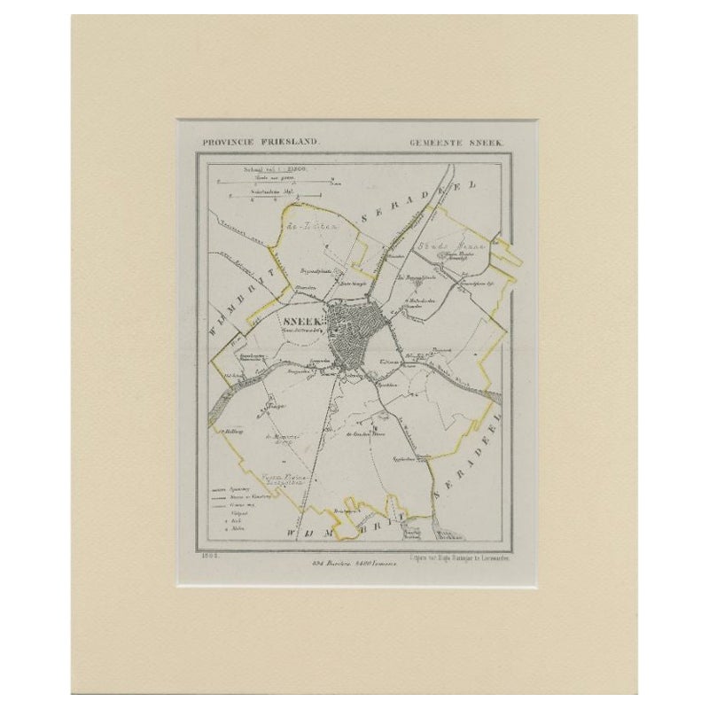
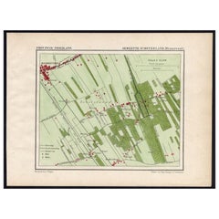
View AllAntique Map of Sneek by Kuyper, 1868
Located in Langweer, NL
Antique map titled 'Provincie Friesland - Gemeente Sneek'. Map of the township of Sneek, Friesland. This map originates from 'Gemeente-Atlas van Nederland' by J. Kuyper. Artists and ...
Category
Antique 19th Century Maps
Materials
Paper
$121 Sale Price
20% Off
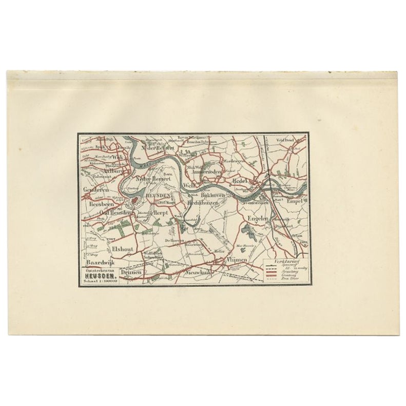
Antique Map of the Region of Heusden by Craandijk, 1884
Located in Langweer, NL
Antique map titled 'Omstreken van Heusden'. Old map of the region of Heusden also including cities and villages like Elshout, Aalburg, Hedel and Vlijmen. This map orginates from 'Atl...
Category
Antique 19th Century Maps
Materials
Paper
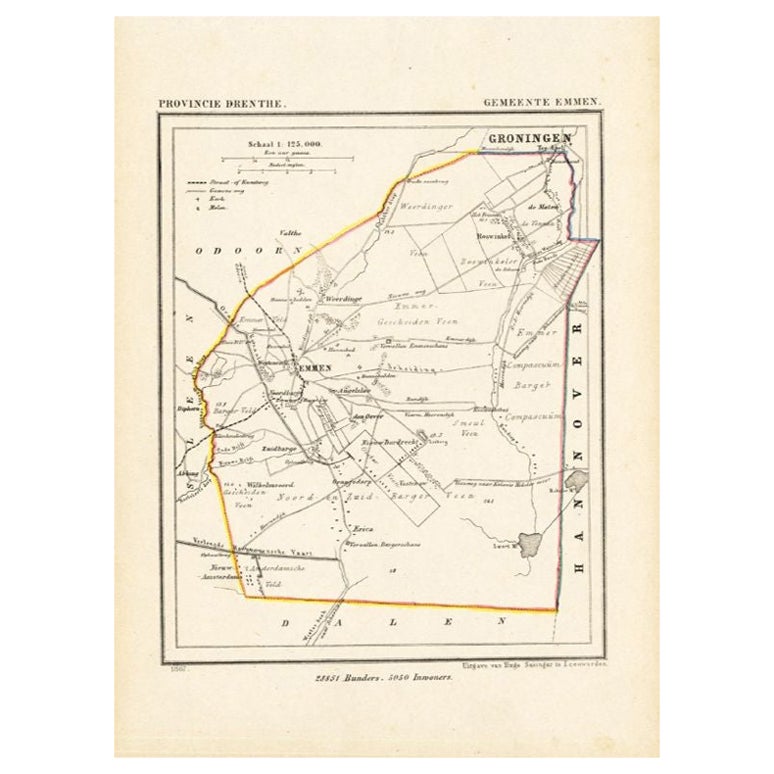
Antique Map of the Township of Emmen, Drenthe in The Netherlands, 1865
Located in Langweer, NL
Drenthe: Gemeente Emmen, Roswinkel, Werdinge, Zuidbarge. These scarse detailed maps of Dutch Towns originate from the 'Gemeente-atlas' of Jacob Kuyper. This atlas of all towns in the...
Category
Antique 19th Century Maps
Materials
Paper
$162 Sale Price
20% Off
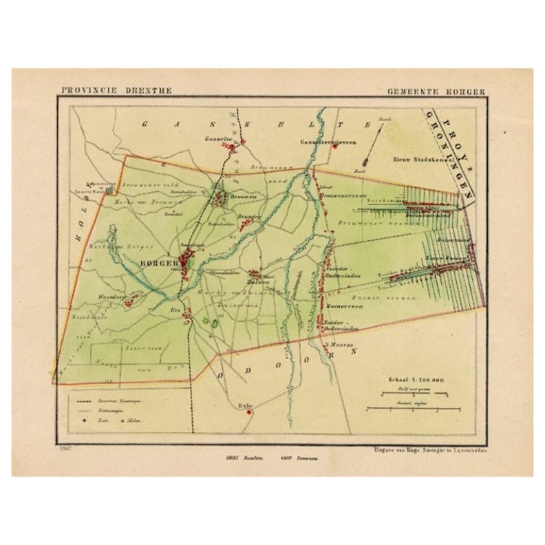
Original Antique Map of the Township of Borger in The Netherlands, 1865
Located in Langweer, NL
Drenthe - Gemeente Borger, Drouwen, Buinene, Westdorp. These scarse detailed maps of Dutch Towns originate from the 'Gemeente-atlas' of Jacob Kuyper. This atlas of all towns in the N...
Category
Antique 19th Century Maps
Materials
Paper
$171 Sale Price
20% Off
Antique Map of the Region of Oranjewoud by Kuyper, 1868
Located in Langweer, NL
Antique map titled 'Provincie Friesland - Gemeente Schoterland (Oranjewoud)'. Map of the township of Schoterland with a focus on the region of Oranjewoud. This map originates from 'G...
Category
Antique 19th Century Maps
Materials
Paper
Antique Map of the Region of Doetinchem by Craandijk, 1884
Located in Langweer, NL
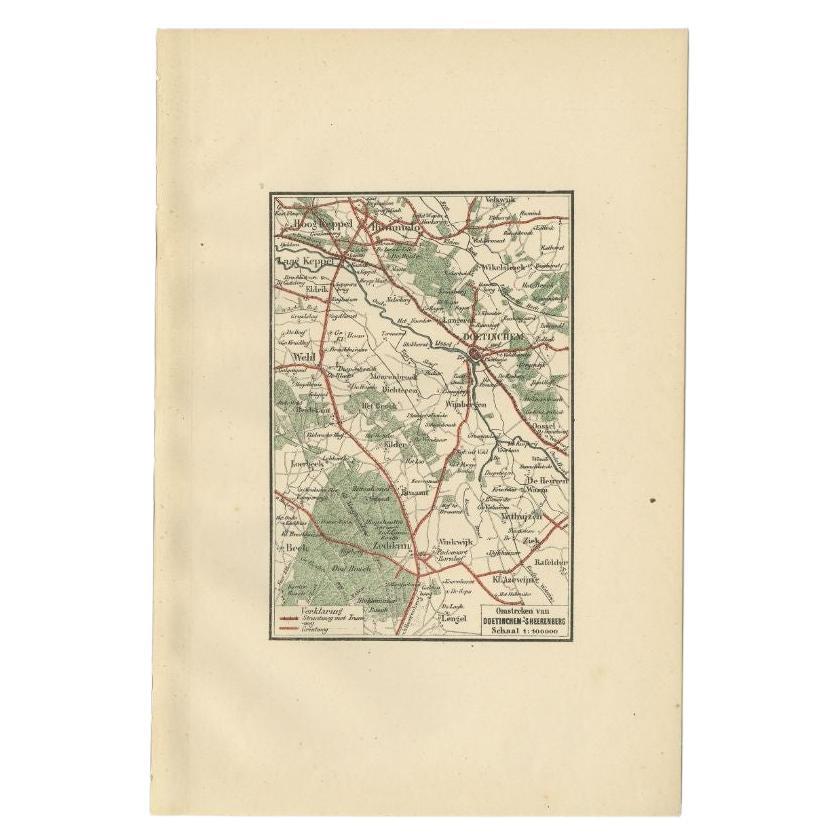
Antique map titled 'Omstreken van Doetinchem - 's Heerenberg'. Old map of the region of Doetinchem also including cities and villages like Keppel, Wehl and Zeddam. This map orginates...
Category
Antique 19th Century Maps
Materials
Paper
You May Also Like
Original Antique English County Map, Buckinghamshire, J
C Walker, 1851
Located in St Annes, Lancashire
Great map of Buckinghamshire
Original colour
By J & C Walker
Published by Longman, Rees, Orme, Brown & Co. 1851
Unframed.
Category
Antique 1850s English Other Maps
Materials
Paper

Original Antique English County Map, Huntingdonshire, J
C Walker, 1851
Located in St Annes, Lancashire
Great map of Huntingdonshire
Original colour
By J & C Walker
Published by Longman, Rees, Orme, Brown & Co. 1851
Unframed.
Category
Antique 1850s English Other Maps
Materials
Paper

Original Antique English County Map, Cambridgeshire, J
C Walker, 1851
Located in St Annes, Lancashire
Great map of Cambridgeshire
Original colour
By J & C Walker
Published by Longman, Rees, Orme, Brown & Co. 1851
Unframed.
Category
Antique 1850s English Other Maps
Materials
Paper

Original Antique English County Map, Leicestershire, J
C Walker, 1851
Located in St Annes, Lancashire
Great map of Leicestershire
Original colour
By J & C Walker
Published by Longman, Rees, Orme, Brown & Co. 1851
Unframed.
Category
Antique 1850s English Other Maps
Materials
Paper

Original Antique English County Map, Warwickshire, J
C Walker, 1851
Located in St Annes, Lancashire
Great map of Warwickshire
Original colour
By J & C Walker
Published by Longman, Rees, Orme, Brown & Co. 1851
Unframed.
Category
Antique 1850s English Other Maps
Materials
Paper

Original Antique English County Map, Nottinghamshire, J
C Walker, 1851
Located in St Annes, Lancashire
Great map of Nottinghamshire
Original colour
By J & C Walker
Published by Longman, Rees, Orme, Brown & Co. 1851
Unframed.
Category
Antique 1850s English Other Maps
Materials
Paper

More Ways To Browse
1868 Furniture
Ptolemy Map
Antique Maps Massachusetts
Antique Maps Singapore
Antique Planisphere
Map Of Palestine
R Johnston
Santa Cruz Island
Shetland Map
Antique Alabama Map
Antique Framed Map Engravings
Antique Furniture Cheshire
Antique Great Lakes Map
Antique Map Of Michigan
Antique Map Of Turkish Empire
Antique Map Of Yorkshire
Bali Map
Bermuda Map