Items Similar to Antique Map of Overijssel by Visscher, 1632
Want more images or videos?
Request additional images or videos from the seller
1 of 5
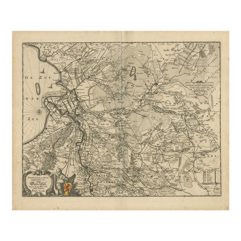
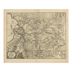
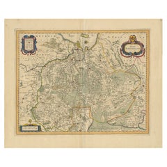
Antique Map of Overijssel by Visscher, 1632
$493.26
$616.5720% Off
£365.37
£456.7220% Off
€410.40
€51320% Off
CA$674.76
CA$843.4520% Off
A$735.46
A$919.3220% Off
CHF 388.83
CHF 486.0420% Off
MX$8,853.50
MX$11,066.8820% Off
NOK 4,935.21
NOK 6,169.0220% Off
SEK 4,524.58
SEK 5,655.7320% Off
DKK 3,127.02
DKK 3,908.7820% Off
About the Item
Antique map titled 'De Heerlyckheyt van Over-IJssel'. Old map of the province of Overijssel, the Netherlands. Also depicted are various coats of arms. Artists and Engravers: Engraved by A. Goos, published by C.J. Visscher. laes Janszoon Visscher (1587 ? 19 June 1652) was a Dutch Golden Age draughtsman, engraver, mapmaker and publisher. He was also known as Nicolas Joannes Piscator.
Artist: Engraved by A. Goos, published by C.J. Visscher. laes Janszoon Visscher (1587 ? 19 June 1652) was a Dutch Golden Age draughtsman, engraver, mapmaker and publisher. He was also known as Nicolas Joannes Piscator.
Condition: Fair, general age-related toning and some foxing. Minor tears and defects, repair on folding line. Please study image carefully.
Date: 1632
Overall size: 55.5 x 47 cm.
Image size: 0.001 x 50.5 x 39 cm.
Antique prints have long been appreciated for both their aesthetic and investment value. They were the product of engraved, etched or lithographed plates. These plates were handmade out of wood or metal, which required an incredible level of skill, patience and craftsmanship. Whether you have a house with Victorian furniture or more contemporary decor an old engraving can enhance your living space. We offer a wide range of authentic antique prints for any budget.
- Dimensions:Height: 18.51 in (47 cm)Width: 21.86 in (55.5 cm)Depth: 0 in (0.01 mm)
- Materials and Techniques:
- Period:
- Date of Manufacture:1632
- Condition:
- Seller Location:Langweer, NL
- Reference Number:Seller: BG-11880-11stDibs: LU3054327618062
About the Seller
5.0
Recognized Seller
These prestigious sellers are industry leaders and represent the highest echelon for item quality and design.
Platinum Seller
Premium sellers with a 4.7+ rating and 24-hour response times
Established in 2009
1stDibs seller since 2017
2,813 sales on 1stDibs
Typical response time: 1 hour
- ShippingRetrieving quote...Shipping from: Langweer, Netherlands
- Return Policy
More From This Seller
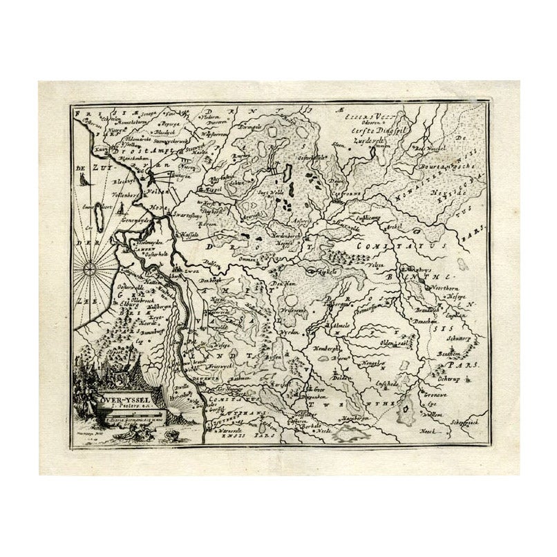
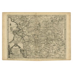
View AllAntique Map of Overijssel by Visscher, c.1652
Located in Langweer, NL
Antique map titled 'Transisalania provincia vulgo Over-yssel'. Original antique map of the province of Overijssel, the Netherlands. Published by N. Visscher after N. ten Have, circa ...
Category
Antique 17th Century Maps
Materials
Paper
$526 Sale Price
20% Off
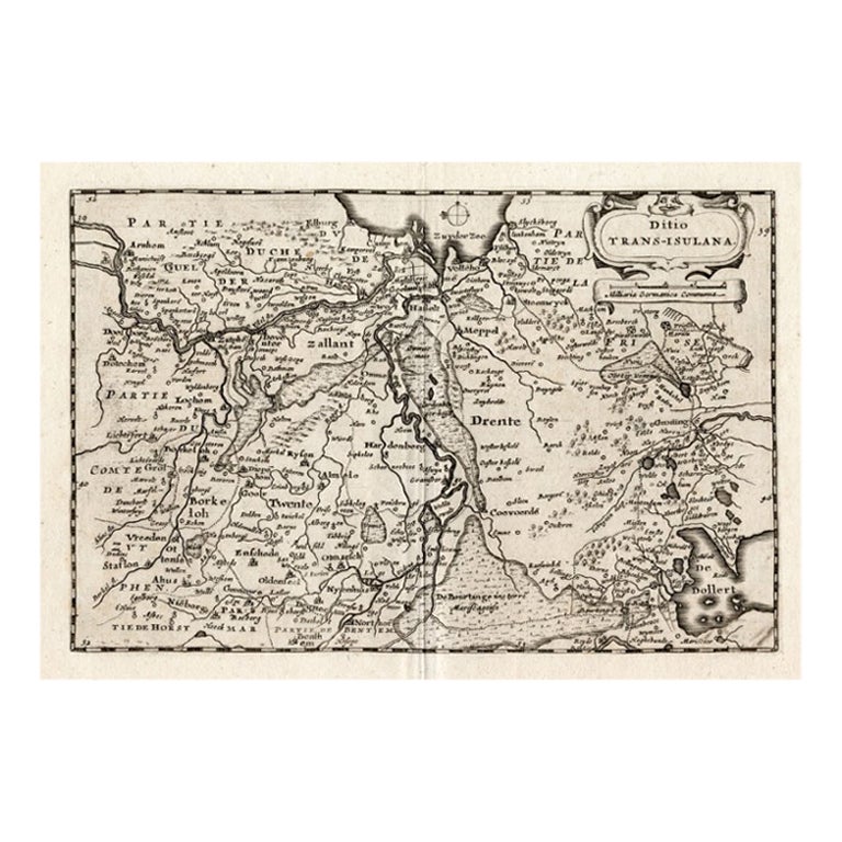
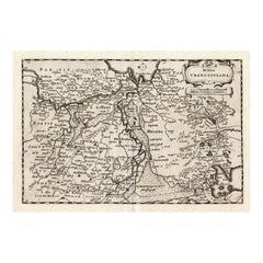
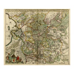
Antique Map of Overijssel by Colom, 1635
Located in Langweer, NL
Antique map titled 'Ditio Trans-Isulana'. Original antique map of the province of Overijssel, the Netherlands. This map originates from 'Vyerige Colom verthonende de 17 Nederlandsche...
Category
Antique 17th Century Maps
Materials
Paper
$211 Sale Price
20% Off
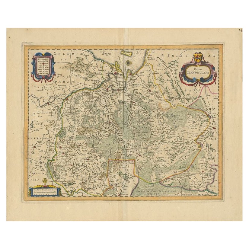
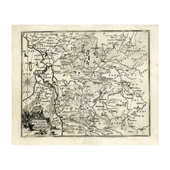
Antique Map of the Province of Overijssel by Janssonius, c.1650
Located in Langweer, NL
Antique map titled 'Ditio Trans-isulana'. Original antique map of the province of Overijssel, the Netherlands. With coat of arms and two decorative cartouches. Published by J. Jansso...
Category
Antique 17th Century Maps
Materials
Paper
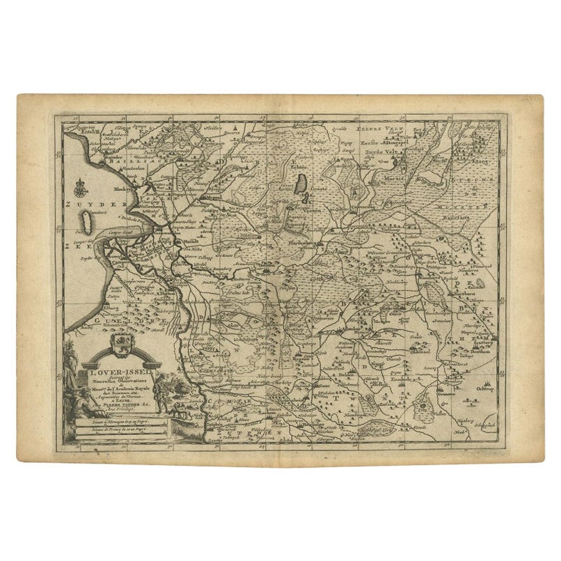
Antique Map of Overijssel by Van der Aa, c.1715
Located in Langweer, NL
Antique map titled 'L'Over-Issel'. This map depicts the Dutch province Overijssel. This map originates from 'Nouvel Atlas, très exact et fort commode pour toutes sortes de personnes,...
Category
Antique 18th Century Maps
Materials
Paper
$182 Sale Price
20% Off
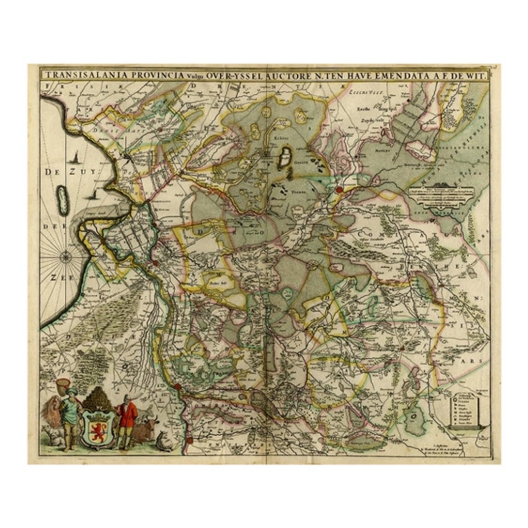
Antique Map of Overijssel by De Wit, c.1680
Located in Langweer, NL
Antique map titled 'Transisalania Provincia Vulgo Over-Yssel'. Original antique map of Overijssel, the Netherlands, showing the regio between Zutphen, Zwolle, Blokzijl, Coevorden, Ol...
Category
Antique 17th Century Maps
Materials
Paper
$427 Sale Price
20% Off
Antique Map of Overijssel by Bachiene, 1758
Located in Langweer, NL
Antique map titled 'Over-Yssel'. Map of the Overijssel, the Netherlands. This map originates from 'Kort begrip der Oude en Nieuwe Staatkundige Geographie', by W.A. Bachiene, publishe...
Category
Antique 18th Century Maps
Materials
Paper
$163 Sale Price
20% Off
You May Also Like
1646 Jansson Map Entitled "Procinvia Connactiae, " Ric.a006
Located in Norton, MA
1646 Jansson map entitled
"Procinvia connactiae,"
Ric.a006
Description: The PROVINCE of CONNAVGT 490 x 380From vol 4 of Jansson's Atlas Novus 1646, published in Amsterdam with...
Category
Antique 17th Century Unknown Maps
Materials
Paper

1657 Janssonius Map of Vermandois and Cappelle, Ric. A-004
Located in Norton, MA
1657 Janssonius map of
Vermandois and Cappelle
Ric.a004
Description: Antique map of France titled 'Descriptio Veromanduorum - Gouvernement de la Cappelle'. Two detailed maps o...
Category
Antique 17th Century Unknown Maps
Materials
Paper

1635 Willem Blaeu Map of Northern France"Comitatvs Bellovacvm" Ric.a08
Located in Norton, MA
1635 Willem Blaeu map of northern France, entitled.
"Comitatvs Bellovacvm Vernacule Beavvais,"
Colored
Ric.a008
“COMITATVS BELLOVACVM…” Amsterdam: W...
Category
Antique 17th Century Unknown Maps
Materials
Paper

1620 Map of Artois Entitled "Artesia Comitatvs Artois, " by Bleau, Ric.a012
Located in Norton, MA
1640 map of Artois entitled
"Artesia Comitatvs Artois,"
by Bleau
Colored
A-012.
Detailed map of the northern province of Artois, France on the border with Belgium. Feature...
Category
Antique 17th Century Dutch Maps
Materials
Paper

17th Century Hand Colored Map of the Liege Region in Belgium by Visscher
By Nicolaes Visscher II
Located in Alamo, CA
An original 17th century map entitled "Leodiensis Episcopatus in omnes Subjacentes Provincias distincté divisusVisscher, Leodiensis Episcopatus" by Nicolaes Visscher II, published in Amsterdam in 1688. The map is centered on Liege, Belgium, includes the area between Antwerp, Turnhout, Roermond, Cologne, Trier and Dinant.
This attractive map is presented in a cream-colored mat measuring 30" wide x 27.5" high. There is a central fold, as issued. There is minimal spotting in the upper margin and a tiny spot in the right lower margin, which are under the mat. The map is otherwise in excellent condition.
The Visscher family were one of the great cartographic families of the 17th century. Begun by Claes Jansz Visscher...
Category
Antique Late 17th Century Dutch Maps
Materials
Paper

$940 Sale Price
20% Off
1640 Willem Blaeu Map Entitled "Contado di molise et principato vltra, " Ric.a003
By Willem Blaeu
Located in Norton, MA
1640 Willem Blaeu map entitled
"Contado di molise et principato vltra,"
Colored
Ric. a003
Measures: 38 x 49.6 cm and wide margins
DBLAEU.
Cou...
Category
Antique 17th Century Dutch Maps
Materials
Paper

More Ways To Browse
Romania Map
Used Furniture Nova Scotia
18th Century Scottish Collectibles
Antique Furniture Northumberland
Antique Map Nova Scotia
Antique Map Palestine
California Island Map
Constantinople Map
Croatian Antiques
Jamaican Antique
Large Map Of Italy
Louisiana Antiques
Maps South East Asia
New Jersey Antique Furniture
Ptolemy Map
Antique Maps Massachusetts
Antique Maps Singapore
Antique Planisphere