Items Similar to Antique Map of the Pacific Ocean by Anson, 1765

Want more images or videos?
Request additional images or videos from the seller
1 of 5
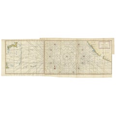
Antique Map of the Pacific Ocean by Anson, 1765
$1,182.98
£876.28
€985
CA$1,618.62
A$1,761.18
CHF 932.52
MX$21,188.19
NOK 11,840.96
SEK 10,833.65
DKK 7,506.51
About the Item
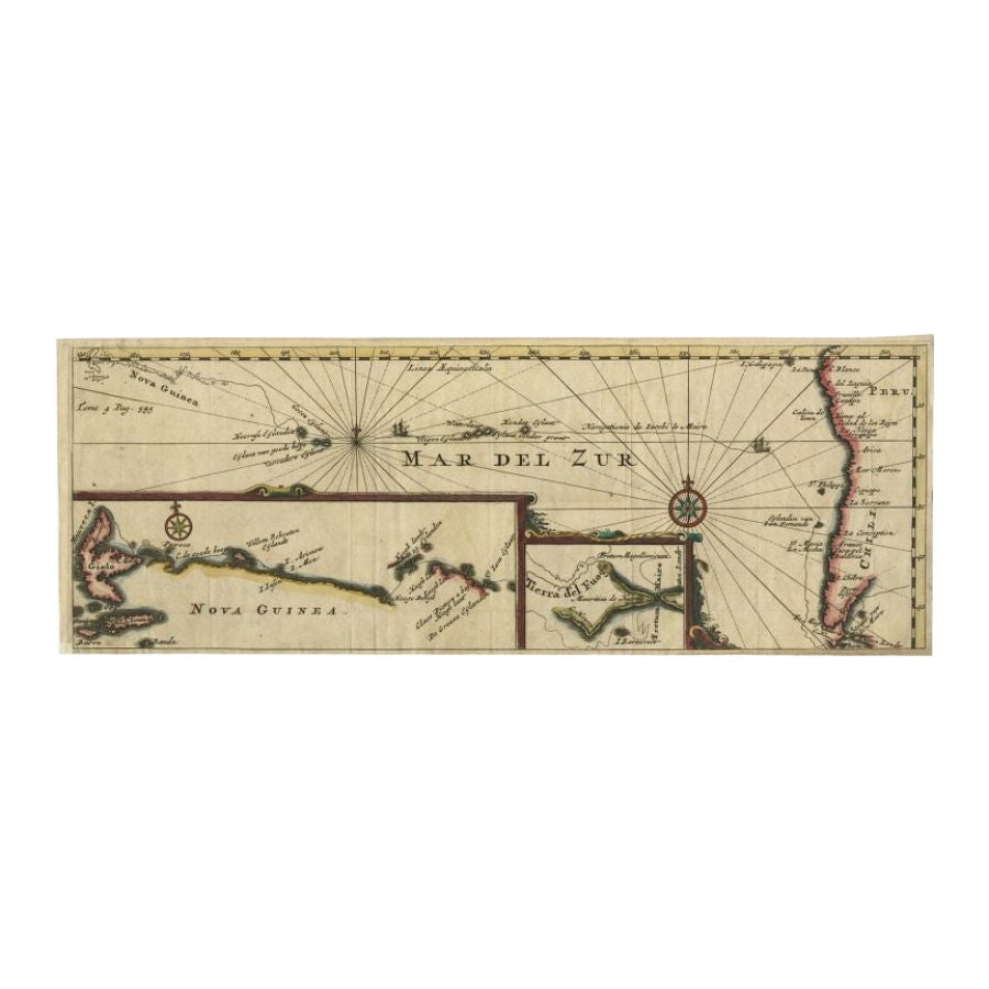
Antique map titled 'Carte de la Mer du Sud ou Mer Pacifique - Kaart van de Zuyd-Zee of stille oceaan (..)'. Nautical chart of the Pacific Ocean depicting the trade routes used by Spanish Galleons from Acapulco in Mexico to Manila in the Philippines. In particular this chart depicts the voyages of the Spanish Nostra Seigniora de Cabadonga and the British Navy Commodore George Anson. Anson succeed in capturing the Spanish treasure galleon off Cape Espiritu Santo on June 20, 1743. Following his capture of the Nostra the treasures were paraded through the streets of London. The map shows the pacific islands and much of the Mexican and California coast. Numerous important destinations along the California coast are named,including Cabo San Lucas, San Diego and Acapulco. This map originates from 'Reize rondsom de Werreld (..) door den heere George Anson'.
Artists and Engravers: George Anson, Baron Anson, British admiral whose four-year voyage around the world is one of the great tales of naval heroism.
We sell original antique maps to collectors, historians, educators and interior decorators all over the world. Our collection includes a wide range of authentic antique maps from the 16th to the 20th centuries. Buying and collecting antique maps is a tradition that goes back hundreds of years. Antique maps have proved a richly rewarding investment over the past decade, thanks to a growing appreciation of their unique historical appeal. Today the decorative qualities of antique maps are widely recognized by interior designers who appreciate their beauty and design flexibility. Depending on the individual map, presentation, and context, a rare or antique map can be modern, traditional, abstract, figurative, serious or whimsical. We offer a wide range of authentic antique maps for any budget.
- Dimensions:Height: 13.98 in (35.5 cm)Width: 35.44 in (90 cm)Depth: 0 in (0.01 mm)
- Materials and Techniques:
- Period:
- Date of Manufacture:1765
- Condition:Repaired: Two small restorations on the folds. Lower left margin partly remargined. Good, given age. A few brown stains upper right. Edges with some tiny and small tears. Original folds as issued. Printed on 2 plates joined together. General age-related toning.
- Seller Location:Langweer, NL
- Reference Number:Seller: PCT-633361stDibs: LU3054327872172
About the Seller
5.0
Recognized Seller
These prestigious sellers are industry leaders and represent the highest echelon for item quality and design.
Platinum Seller
Premium sellers with a 4.7+ rating and 24-hour response times
Established in 2009
1stDibs seller since 2017
2,816 sales on 1stDibs
Typical response time: 1 hour
- ShippingRetrieving quote...Shipping from: Langweer, Netherlands
- Return Policy
More From This Seller
View AllAntique Map of the Coast of Acapulco by Anson, c.1740
Located in Langweer, NL
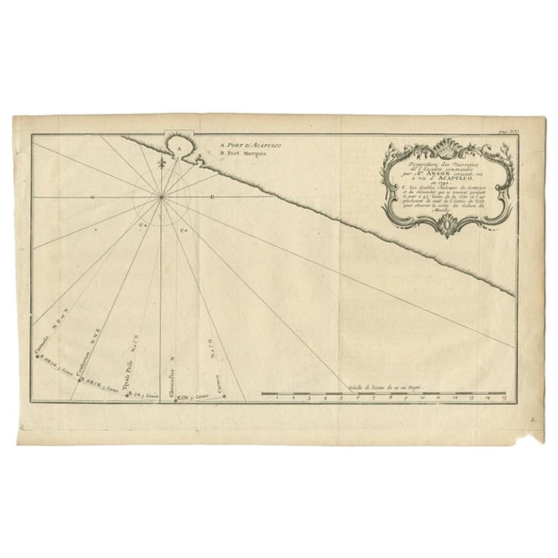
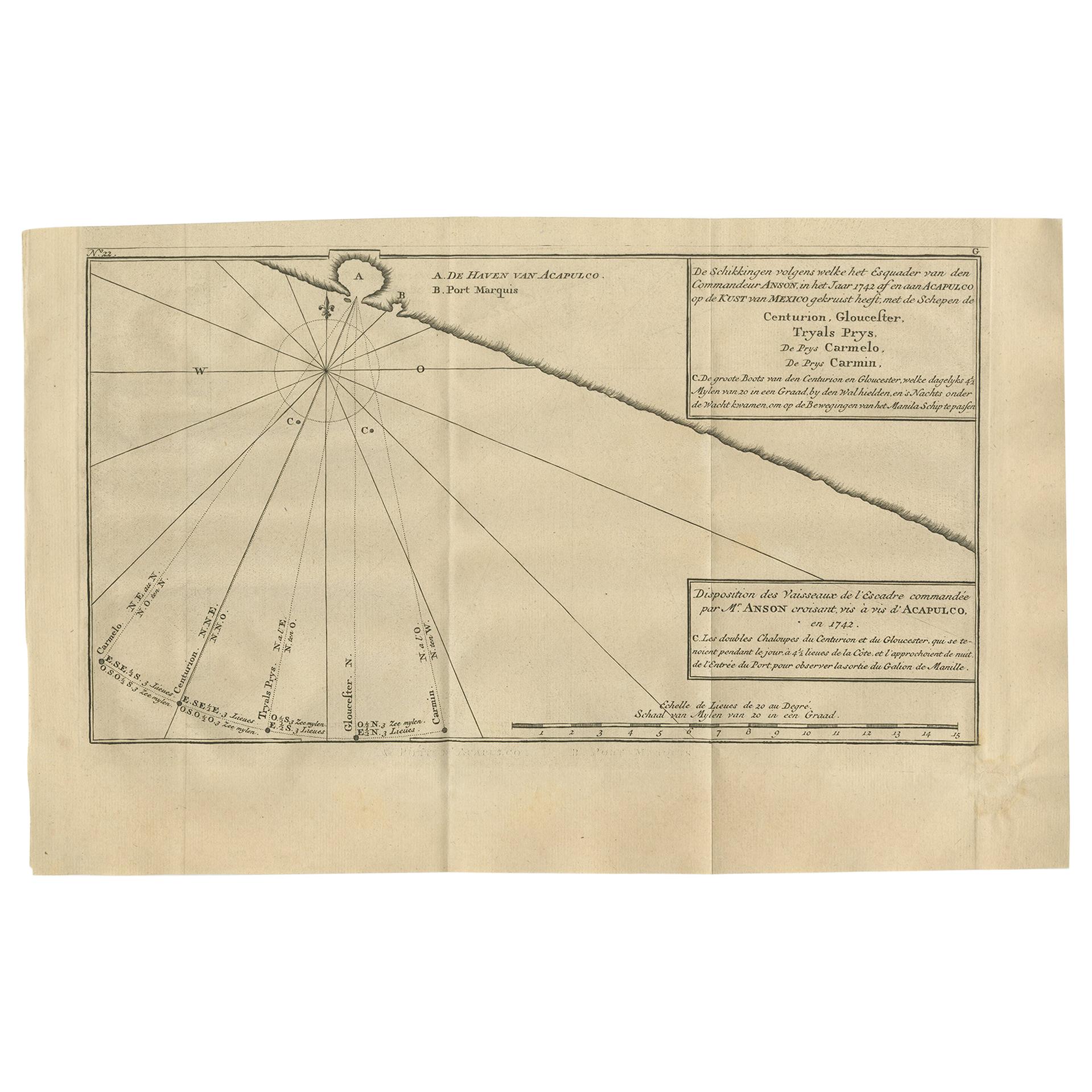
Antique map titled 'Disposition des Vaisseaux de l'Escadre commandée par Mr. Anson croisant vis à vis d'Acapulco en 1742'. This map depicts the coast of Acapulco in Mexico with a decorative cartouche and windrose. Acapulco and its port were important to the Mission of Commodore George Anson, who captured a Spanish treasure...
Category
Antique 18th Century Maps
Materials
Paper
Antique Map of the Bay and Rocks of Petatlan by Anson, 1749
Located in Langweer, NL
Antique map titled 'Baye et Rochers de Petaplan (..) - De Baay en de Rotsen van Petaplan (..)'. Original antique map of the bay and rocks of Petatlan, Mexico. This map originates fro...
Category
Antique 18th Century Maps
Materials
Paper
$153 Sale Price
20% Off
Antique Map of the Coast of Acapulco by Anson, 1749
Located in Langweer, NL
Antique map titled 'Disposition des Vaisseaux de l'Escadre commandée par Mr. Anson croisant vis à vis d'Acapulco en 1742'. This map depicts the coast of Acapulco in Mexico with a decorative cartouche and windrose. Acapulco and its port were important to the mission of Commodore George Anson, who captured a Spanish treasure...
Category
Antique Mid-18th Century Prints
Materials
Paper
$172 Sale Price
42% Off
Antique Chart of the Mid-Pacific Ocean by Anson, c.1784
Located in Langweer, NL
Antique map titled 'Carte de la Mer du Sud ou Mer Pacifique'. Original chart of the mid-Pacific Ocean, includes voyage tracks of Anson’s Centurion and the ship he stalked, the Spanish treasure...
Category
Antique Late 18th Century French Maps
Materials
Paper
$1,351 Sale Price
25% Off
Antique Map of the Pacific Ocean by Renneville, 1725
Located in Langweer, NL
Rare map of the Southern Pacific, illustrating Le Maire's tracks, extending from the La Maire Straits to Nova Guinea, with a large inset of the northern Coastline of New Guinea and a...
Category
Antique 18th Century Maps
Materials
Paper

$432 Sale Price
20% Off
Antique Map of the World with California as an Island, 1788
Located in Langweer, NL
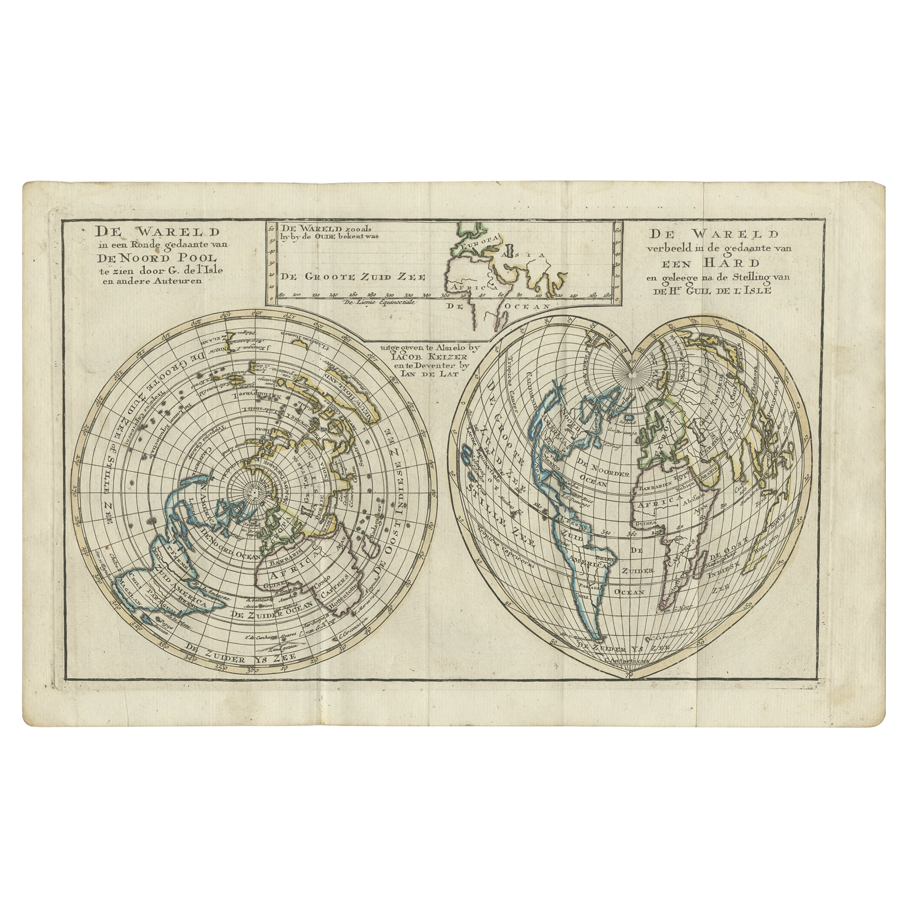
Description: Antique map titled 'De wareld in een ronde gedaante van de Noord Pool te zien - De Wareld verbeeld in de gedaante van een hard'. This interesting composition contains three world maps on the sheet. At left is a northern projection showing all the landmasses. At right is a cordiform projection (heart-shaped). At top is a map of the world as known to the ancients. Both the polar and cordiform projections show California as an island...
Category
Antique 1780s Maps
Materials
Paper

You May Also Like
California, Alaska and Mexico: 18th Century Hand-Colored Map by de Vaugondy
By Didier Robert de Vaugondy
Located in Alamo, CA
This is an 18th century hand-colored map of the western portions of North America entitled "Carte de la Californie et des Pays Nord-Ouest separés de l'Asie par le détroit d'Anian, ex...
Category
Antique 1770s French Maps
Materials
Paper

West Coast of Africa, Guinea
Sierra Leone: An 18th Century Map by Bellin
By Jacques-Nicolas Bellin
Located in Alamo, CA
Jacques Bellin's copper-plate map entitled "Partie de la Coste de Guinee Dupuis la Riviere de Sierra Leona Jusquau Cap das Palmas", depicting the coast of Guinea and Sierra Leone in ...
Category
Antique Mid-18th Century French Maps
Materials
Paper

$460 Sale Price
20% Off
Original Antique Map of South America. C.1780
Located in St Annes, Lancashire
Great map of South America
Copper-plate engraving
Published C.1780
Two small worm holes to left side of map
Unframed.
Category
Antique Early 1800s English Georgian Maps
Materials
Paper

Original Antique Map of The World by Thomas Clerk, 1817
Located in St Annes, Lancashire
Great map of The Eastern and Western Hemispheres
On 2 sheets
Copper-plate engraving
Drawn and engraved by Thomas Clerk, Edinburgh.
Published by Mackenzie And Dent, 1817
...
Category
Antique 1810s English Maps
Materials
Paper

Large Original Antique Map of The Pacific Ocean, Fullarton, C.1870
Located in St Annes, Lancashire
Great map of The Pacific Ocean
From the celebrated Royal Illustrated Atlas
Lithograph by Swanston. Original color.
Published by Fullarton,...
Category
Antique 1870s Scottish Maps
Materials
Paper

Antique Map - Mare Pacificum - Etching by Johannes Janssonius - 1650s
By Johannes Janssonius
Located in Roma, IT
Mare Pacificum is an antique map realized in 1650 by Johannes Janssonius (1588-1664).
The Map is Hand-colored etching, with coeval watercolorang.
Good conditions with slight foxing...
Category
1650s Modern Figurative Prints
Materials
Etching

More Ways To Browse
Spanish Galleon
Naval Antiques
Johann Baptist Homann On Sale
Magellan Map
Map Of Puerto Rico
Map Ukraine
Papua New Guinea Antique Map
Serbia Antique Map
Stanford Antique Furniture
Tipu Sultan
Used Office Furniture Cornwall
Vintage Wooden Roller
Albania Antique Map
Ancient Bible
Antique Bermuda Furniture
Antique Constellation Map
Antique Map Burgundy
Antique Map Of Hawaii