Want more images or videos?
Request additional images or videos from the seller
1 of 6
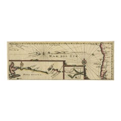
Antique Map of the Pacific Ocean by Renneville, 1702
$522.09List Price
About the Item
- Dimensions:Height: 14.18 in (36 cm)Width: 15.16 in (38.5 cm)Depth: 0 in (0.01 mm)
- Materials and Techniques:
- Period:
- Date of Manufacture:1702
- Condition:Condition: Very good. General age-related toning. Please study image carefully.
- Seller Location:Langweer, NL
- Reference Number:Seller: BG-035251stDibs: LU3054327872242
About the Seller
5.0
Recognized Seller
These prestigious sellers are industry leaders and represent the highest echelon for item quality and design.
Platinum Seller
Premium sellers with a 4.7+ rating and 24-hour response times
Established in 2009
1stDibs seller since 2017
2,836 sales on 1stDibs
Typical response time: 1 hour
Authenticity Guarantee
In the unlikely event there’s an issue with an item’s authenticity, contact us within 1 year for a full refund. DetailsMoney-Back Guarantee
If your item is not as described, is damaged in transit, or does not arrive, contact us within 7 days for a full refund. Details24-Hour Cancellation
You have a 24-hour grace period in which to reconsider your purchase, with no questions asked.Vetted Professional Sellers
Our world-class sellers must adhere to strict standards for service and quality, maintaining the integrity of our listings.Price-Match Guarantee
If you find that a seller listed the same item for a lower price elsewhere, we’ll match it.Trusted Global Delivery
Our best-in-class carrier network provides specialized shipping options worldwide, including custom delivery.You May Also Like
Large Original Antique Map of The Pacific Ocean, Fullarton, C.1870
Located in St Annes, Lancashire
Great map of The Pacific Ocean
From the celebrated Royal Illustrated Atlas
Lithograph by Swanston. Original color.
Published by Fullarton,...
Category
Antique 1870s Scottish Maps
Materials
Paper

$60
Free Shipping
H 18.5 in W 22.5 in D 0.07 in
Original Antique Map of US Possessions In The Pacific Ocean, C.1900
Located in St Annes, Lancashire
Fabulous map of US possessions in the Pacific Ocean
Original color.
Engraved and printed by the George F. Cram Company, Indianapolis.
Published, C.1900.
Unframed.
Free shipping.
Category
Antique 1890s American Maps
Materials
Paper

$60
Free Shipping
H 11.5 in W 14.5 in D 0.07 in
Large Original Vintage Map of The Pacific Islands Including Hawaii
Located in St Annes, Lancashire
Great map of The Pacific Islands
Unframed
Original color
By John Bartholomew and Co. Edinburgh Geographical Institute
Published, circa 1...
Category
Vintage 1920s British Maps
Materials
Paper

$45
Free Shipping
H 18 in W 23 in D 0.07 in
The Overland Guide From the Missouri River to the Pacific Ocean, Revised, 1883
Located in Colorado Springs, CO
Gleed, Charles S, ed. Rand, McNally & Co.'s Overland Guide From the Missouri River to the Pacific Ocean Via Kansas, Colorado, New Mexico, Arizona and California. Chicago: Rand, McNally & Co., 1883. Revised Edition. Rebound in ¼ red leather and cloth boards, with original cloth gilt-stamped pictorial front board saved, new marbled endpapers, and a custom archival slipcase to match. Illustrated throughout with engravings.
This is a “Revised Edition” of the Rand, McNally & Co.'s Overland Guide From the Missouri River to the Pacific Ocean, via Kansas, Colorado, New Mexico, Arizona and California. The book was edited by Charles S. Gleed and published by Rand, McNally & Co., in Chicago in 1883. It has been artfully rebound in ¼ red leather and cloth boards, with the original gilt-stamped pictorial front cloth board saved, new marbled endpapers, and a matching archival cloth slipcase.
As explained in the beginning of the guidebook, the purpose of the book is “to give the reader a satisfactory general idea of the States and Territories of Kansas, Colorado, New Mexico, Arizona, and California, through which the traveler passes in going from the Missouri river to the Pacific ocean, or vice versa, entering or leaving California at its southern extremity.” Following the southern route of railways, editor Charles Gleed lays out in extensive detail information on each state, including population numbers, key industries, important towns and railway stations, farming and agriculture, mining opportunities, and weather patterns.
Throughout the guidebook are countless engravings, both full page and in-text, from well known engravers of the time. Meant to further entice readers to take this overland journey, the illustrations offer views of key tourist spots, townviews, and scenic destinations, throughout the featured states of Kansas, Colorado, New Mexico, Arizona, and California. The guidebook is also supplemented by pages of printed advertisements in the beginning of the book, showcasing local businesses, services, and wares.
Charles Sumner...
Category
Antique 1880s American Late Victorian Books
Materials
Leather, Fabric, Paper
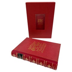
$1,500
H 8.38 in W 6 in D 1.63 in
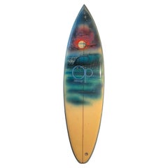
Vintage 1970s Ocean Pacific Wave Mural Surfboard
Located in Haleiwa, HI
Vintage 1970s Ocean Pacific (Op) wave mural surfboard. Features stunning airbrushed work of art depicting a nocturnal wave mural. Rounded pintail shape design. A beautiful example of...
Category
Vintage 1970s American Sports Equipment and Memorabilia
Materials
Fiberglass, Foam, Softwood
Original Antique Map of The Philippines. C.1900
Located in St Annes, Lancashire
Fabulous map of The Philippines
Original color.
Engraved and printed by the George F. Cram Company, Indianapolis.
Published, C.1900.
Unframed.
Free shipping.
Category
Antique 1890s American Maps
Materials
Paper

Original Antique Map of The World by Thomas Clerk, 1817
Located in St Annes, Lancashire
Great map of The Eastern and Western Hemispheres
On 2 sheets
Copper-plate engraving
Drawn and engraved by Thomas Clerk, Edinburgh.
Published by Mackenzie And Dent, 1817
...
Category
Antique 1810s English Maps
Materials
Paper

$90 / set
Free Shipping
H 10.25 in W 8.25 in D 0.07 in
Original Antique Map of The World by Dower, circa 1835
Located in St Annes, Lancashire
Nice map of the World
Drawn and engraved by J.Dower
Published by Orr & Smith. C.1835
Unframed.
Free shipping
Category
Antique 1830s English Maps
Materials
Paper

$60
Free Shipping
H 9.25 in W 12.25 in D 0.07 in
Original Antique Map of The Western Hemisphere by Dower, circa 1835
Located in St Annes, Lancashire
Nice map of the Western Hemisphere
Drawn and engraved by J.Dower
Published by Orr & Smith. C.1835
Unframed.
Free shipping
Category
Antique 1830s English Maps
Materials
Paper

$60
Free Shipping
H 9.25 in W 12.25 in D 0.07 in
Original Antique Map of The Eastern Hemisphere by Dower, circa 1835
Located in St Annes, Lancashire
Nice map of the Eastern Hemisphere
Drawn and engraved by J.Dower
Published by Orr & Smith. C.1835
Unframed.
Free shipping
Category
Antique 1830s English Maps
Materials
Paper

$60
Free Shipping
H 9.25 in W 12.25 in D 0.07 in
More From This Seller
View AllAntique Map of the Pacific Ocean by Renneville, 1725
Located in Langweer, NL
Rare map of the Southern Pacific, illustrating Le Maire's tracks, extending from the La Maire Straits to Nova Guinea, with a large inset of the northern Coastline of New Guinea and a...
Category
Antique 18th Century Maps
Materials
Paper
$427 Sale Price
20% Off
Antique Map of the Pacific Ocean by Rienzi, 1836
Located in Langweer, NL
Antique map titled 'Mélanésie'. Map of the Pacific ocean around Australia, including Java, Timor, the Solomon Islands and New Zealand. This print or...
Category
Antique 19th Century Maps
Materials
Paper

Antique Map of the Pacific Ocean by Anson, 1765
Located in Langweer, NL
Antique map titled 'Carte de la Mer du Sud ou Mer Pacifique - Kaart van de Zuyd-Zee of stille oceaan (..)'. Nautical chart of the Pacific Ocean depicting the trade routes used by Spanish Galleons from Acapulco in Mexico to Manila in the Philippines. In particular this chart depicts the voyages of the Spanish Nostra Seigniora de Cabadonga and the British Navy Commodore George Anson. Anson succeed in capturing the Spanish treasure...
Category
Antique 18th Century Maps
Materials
Paper

Antique Map of the Islands in the Pacific Ocean by Wyld,
1845
Located in Langweer, NL
Antique map titled 'Islands in the Pacific Ocean'. Original antique map of the islands in the Pacific Ocean. This map originates from 'An Atlas of the World, Comprehending Separate M...
Category
Antique Mid-19th Century Maps
Materials
Paper

$189 Sale Price
20% Off
Antique Map of South Pacific Ocean by W. G. Blackie, 1859
Located in Langweer, NL
Antique map titled 'South Pacific Ocean'. Original antique map of South Pacific Ocean with inset Map of Tahiti. This map originates from ‘The Imperial Atlas of Modern Geography’. Pub...
Category
Antique Mid-19th Century Maps
Materials
Paper
$237 Sale Price
20% Off
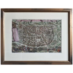
Antique Map of the City of Jerusalem by N. Visscher, 1702
Located in Langweer, NL
Antique map titled 'Die Heylige en Wytvermaerde stadt Jerusalem Eerst Genaemt Salem, Genesis 14 vers 18'. This map originates from 'Biblia. Ouden ende Nieuwen Testaments (..)'. Publi...
Category
Antique Early 18th Century Dutch Maps
Materials
Paper
$3,274 Sale Price
20% Off
Still Thinking About These?
All Recently ViewedMore Ways To Browse
Compagnie Des Indes
Johann Baptist Homann On Sale
Magellan Map
Map Of Puerto Rico
Map Ukraine
Papua New Guinea Antique Map
Serbia Antique Map
Stanford Antique Furniture
Tipu Sultan
Used Office Furniture Cornwall
Vintage Wooden Roller
Albania Antique Map
Ancient Bible
Antique Bermuda Furniture
Antique Constellation Map
Antique Map Burgundy
Antique Map Of Hawaii
Antique Maps Of Long Island