Items Similar to Antique Map of Part of Russia by Spyk, c.1740


Want more images or videos?
Request additional images or videos from the seller
1 of 5
Antique Map of Part of Russia by Spyk, c.1740
$146.48
$183.1020% Off
£109.66
£137.0720% Off
€122.40
€15320% Off
CA$201.65
CA$252.0620% Off
A$220.44
A$275.5520% Off
CHF 116.62
CHF 145.7820% Off
MX$2,637.94
MX$3,297.4220% Off
NOK 1,483.87
NOK 1,854.8320% Off
SEK 1,358.33
SEK 1,697.9120% Off
DKK 932.54
DKK 1,165.6720% Off
About the Item
Antique map titled 'Mappa Geogr: Continens partem Russici Imperii (..)'. Old map of part of Russia including the city of Moscow, Vologda, Tobolsk and others. Source unknown, to be determined. Artists and Engravers: Engraved by J. v.d. Spyk.
Artist: Engraved by J. v.d. Spyk.
Condition: Good, general age-related toning. Minor wear and light soiling. Blank verso, please study image carefully.
Date: c.1740
Overall size: 38 x 30 cm.
Image size: 0.001 x 33.5 x 26 cm.
Antique prints have long been appreciated for both their aesthetic and investment value. They were the product of engraved, etched or lithographed plates. These plates were handmade out of wood or metal, which required an incredible level of skill, patience and craftsmanship. Whether you have a house with Victorian furniture or more contemporary decor an old engraving can enhance your living space. We offer a wide range of authentic antique prints for any budget.
- Dimensions:Height: 11.82 in (30 cm)Width: 14.97 in (38 cm)Depth: 0 in (0.01 mm)
- Materials and Techniques:
- Period:
- Date of Manufacture:circa 1740
- Condition:
- Seller Location:Langweer, NL
- Reference Number:Seller: BG-12290-41stDibs: LU3054327621712
About the Seller
5.0
Recognized Seller
These prestigious sellers are industry leaders and represent the highest echelon for item quality and design.
Platinum Seller
Premium sellers with a 4.7+ rating and 24-hour response times
Established in 2009
1stDibs seller since 2017
2,793 sales on 1stDibs
Typical response time: <1 hour
- ShippingRetrieving quote...Shipping from: Langweer, Netherlands
- Return Policy
More From This Seller
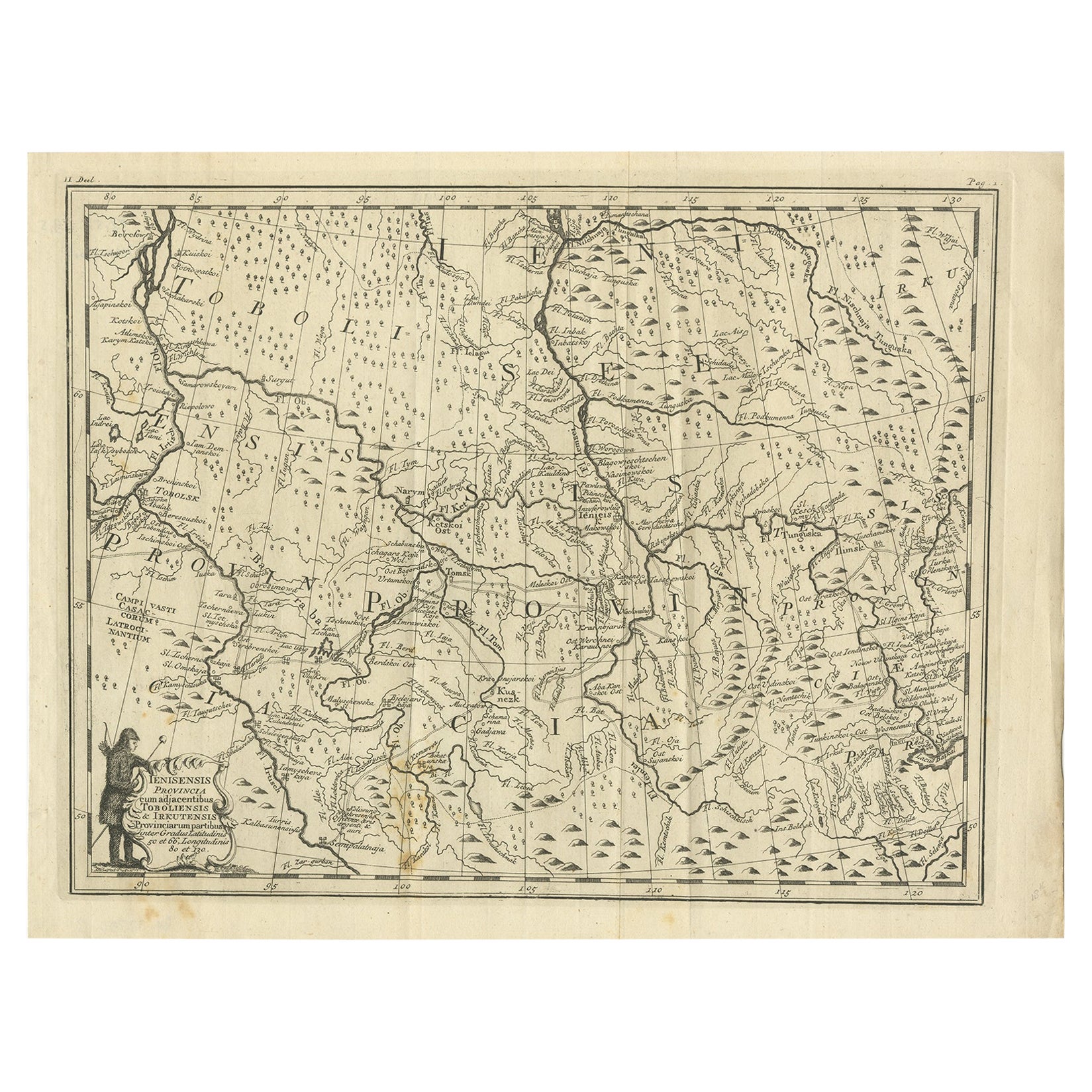
View AllAntique Map of Part of Russia, c.1740
Located in Langweer, NL
Antique map titled 'Ienisensis Provinicia cum adjacentibus Toboliensis & Irkutensis'. Old map of part of Russia including the city of Tobolsk and others. Source unknown, to be determ...
Category
Antique 18th Century Maps
Materials
Paper
$131 Sale Price
20% Off
Antique Map of Russia by N. Sanson, 1705
Located in Langweer, NL
A strongly engraved map of European Russia showing its political divisions, major topographical features, cities and towns. Extends to the Sea of Azov and the tip of the Caspian Sea ...
Category
Antique Early 18th Century French Maps
Materials
Paper

Antique Map of Russia in Europe by T. Kitchin, circa 1770
Located in Langweer, NL
Antique map titled 'Russia or Moscovy in Europe, drawn from the latest authorities (..)'. An interesting and attractive early 19th century map of Russia in Europe which was engraved ...
Category
Antique Late 18th Century Maps
Materials
Paper

Antique Map of Moscovy
Russia
by E. Bowen, 1747
Located in Langweer, NL
Beautiful map of European Russia by the English cartographer Emmanuel Bowen. It depicts the European portion of Russia extending from the Gulf of Finland to the Ural Mountains. The m...
Category
Antique Mid-18th Century Maps
Materials
Paper

Antique Map of European Russia by Tirion, c.1725
Located in Langweer, NL
Antique map titled 'Nieuwe Kaart van Muskovie of Rusland na de laatste ondekking int licht gebracht te Amsterdam by Isaak Tirion'. Detailed map of European Russia.
Artists and En...
Category
Antique 18th Century Maps
Materials
Paper

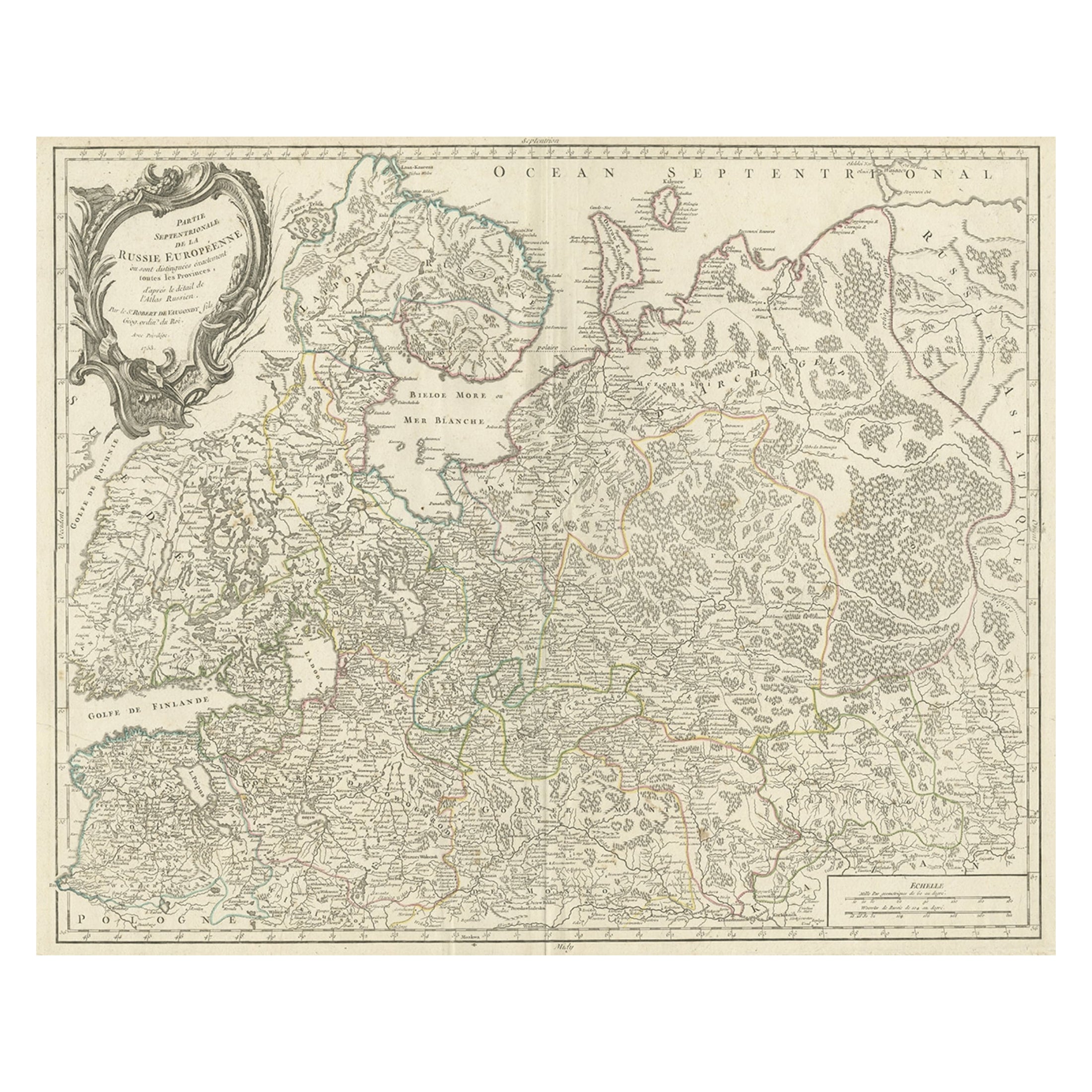
Original Antique Map of the Northwestern Part of Russia in Europe, 1753
Located in Langweer, NL
Antique map titled 'Partie septentrionale de la Russie Européenne'.
Detailed map of the Northwestern part of Russia, from the Gulf of Finland and Poland, to the western part of Asian Russia.
Artists and Engravers: Gilles Robert de Vaugondy (1688-1766) was the head of a leading family of geographers in eighteenth century France. Gilles got his start when he jointly inherited the shop of Pierre-Moullart Sanson, grandson of the famous geographer Nicholas Sanson. The inheritance included the business, its stock of plates, and a roller press...
Category
Antique 1750s Maps
Materials
Paper
$564 Sale Price
20% Off
You May Also Like
Von Reilly Map of the Russian Empire, 1796
Located in Savannah, GA
A map of the Russian Empire in Europe by Von Reilly. Published in Vienna, 1796.
32 inches wide by 24 ½ inches tall
Category
Antique 1790s Austrian Prints
Materials
Glass, Wood, Paper

1853 Map of "Russia in Europe Including Poland" Ric.r016
Located in Norton, MA
Description
Russia in Europe incl. Poland by J Wyld c.1853
Hand coloured steel engraving
Dimension: Paper: 25 cm W x 33 cm H ; Sight: 22 cm W x 28 cm H
Condition: Good ...
Category
Antique 19th Century Unknown Maps
Materials
Paper

1849 Map of "Europaische Russland",
Meyer Map of European Russia
, Ric. R017
Located in Norton, MA
1849 Map of
"Europaische Russland"
( Meyer Map of European Russia)
Ric.r017
A lovely map of European Russia dating to 1849 by Joseph Meyer. It covers the European portions of...
Category
Antique 19th Century Unknown Maps
Materials
Paper

1790 Thomas Stackhouse Map, Entitled "Russia in Europe, " , Ric.a004
Located in Norton, MA
1790 Thomas Stackhouse map, entitled
"Russia in Europe"
Ric.a004
Stackhouse, Thomas
Russia in Europe [map]
London: T. Stackhouse, 1783. Map. Matted hand-colored copper engraving. Image size: 14.5 x 15.25 inches. Mat size: 22.75 x 23.75 inches. A beautiful example of this map of Eastern Europe...
Category
Antique 17th Century Unknown Maps
Materials
Paper

1646 Jansson Map Entitled "Procinvia Connactiae, " Ric.a006
Located in Norton, MA
1646 Jansson map entitled
"Procinvia connactiae,"
Ric.a006
Description: The PROVINCE of CONNAVGT 490 x 380From vol 4 of Jansson's Atlas Novus 1646, published in Amsterdam with...
Category
Antique 17th Century Unknown Maps
Materials
Paper

Large Original Antique Map of Poland by Sidney Hall, 1847
Located in St Annes, Lancashire
Great map of Poland
Drawn and engraved by Sidney Hall
Steel engraving
Original colour outline
Published by A & C Black. 1847
Unframed
...
Category
Antique 1840s Scottish Maps
Materials
Paper

More Ways To Browse
Jamaican Antique
Large Map Of Italy
Louisiana Antiques
Maps South East Asia
New Jersey Antique Furniture
Ptolemy Map
Antique Maps Massachusetts
Antique Maps Singapore
Antique Planisphere
Map Of Palestine
R Johnston
Santa Cruz Island
Shetland Map
Antique Alabama Map
Antique Framed Map Engravings
Antique Furniture Cheshire
Antique Great Lakes Map
Antique Map Of Michigan