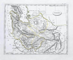
Items Similar to Antique Map of Persia and Tartary by Lowry,
1852


Want more images or videos?
Request additional images or videos from the seller
1 of 5
Antique Map of Persia and Tartary by Lowry,
1852
$94.92
$118.6620% Off
£70.87
£88.5820% Off
€80
€10020% Off
CA$131.88
CA$164.8520% Off
A$141.85
A$177.3220% Off
CHF 75.81
CHF 94.7620% Off
MX$1,672.06
MX$2,090.0820% Off
NOK 955.80
NOK 1,194.7520% Off
SEK 873.78
SEK 1,092.2320% Off
DKK 609.69
DKK 762.1120% Off
About the Item
Antique map titled 'Persia and Tartary'. Original map of Persia and Tartary. This map originates from 'Lowry's Table Atlas constructed and engraved from the most recent Authorities' by J.W. Lowry. Published 1852.
- Dimensions:Height: 12.21 in (31 cm)Width: 9.65 in (24.5 cm)Depth: 0.02 in (0.5 mm)
- Materials and Techniques:
- Period:
- Date of Manufacture:1852
- Condition:General age-related toning, blank verso. Minor wear, please study image carefully.
- Seller Location:Langweer, NL
- Reference Number:Seller: BG-12593-231stDibs: LU3054321548722
About the Seller
5.0
Recognized Seller
These prestigious sellers are industry leaders and represent the highest echelon for item quality and design.
Platinum Seller
Premium sellers with a 4.7+ rating and 24-hour response times
Established in 2009
1stDibs seller since 2017
2,838 sales on 1stDibs
Typical response time: 1 hour
- ShippingRetrieving quote...Shipping from: Langweer, Netherlands
- Return Policy
More From This Seller
View AllAntique Map of Eastern Persia, 1852
Located in Langweer, NL
Antique map titled 'Eastern Persia'. Original map of Eastern Persia. This map originates from 'Lowry's Table Atlas constructed and engraved from the most recent Authorities' by J.W. ...
Category
Antique Mid-19th Century Maps
Materials
Paper

$94 Sale Price
20% Off
Persia Unveiled: Antique Map of Iran, Afghanistan, and Beyond, 1852
Located in Langweer, NL
The antique map titled 'Royaumes de Perse Herat & Kaboul' is an attractive map of Persia. Here are the key details and features of the map:
1. **Geographic Coverage**:
- The map ...
Category
Antique Mid-19th Century French Maps
Materials
Paper

$151 Sale Price
20% Off
Antique Map of Persia and Afghanistan by Johnston, 1882
Located in Langweer, NL
Antique map titled 'Persia and Afghanistan'.
Old map of Persia and Afghanistan. This map originates from 'The Royal Atlas of Modern Geography, Exhibiting, in a Series of Entirely O...
Category
Antique 19th Century Maps
Materials
Paper

Antique Map of Afghanistan and Surroundings,
1845
Located in Langweer, NL
Antique map titled 'Map of Persia and Caubul'. Original antique map of Afghanistan and surroundings.
This map originates from 'An Atlas of the World, Comprehending Separate Maps of...
Category
Antique Mid-19th Century Maps
Materials
Paper

$189 Sale Price
20% Off
Antique Map of Persia and Afghanistan by Johnston
1909
Located in Langweer, NL
Antique map titled 'Persia and Afghanistan'. Original antique map of Persia and Afghanistan. This map originates from the ‘Royal Atlas o...
Category
Early 20th Century Maps
Materials
Paper

$237 Sale Price
20% Off
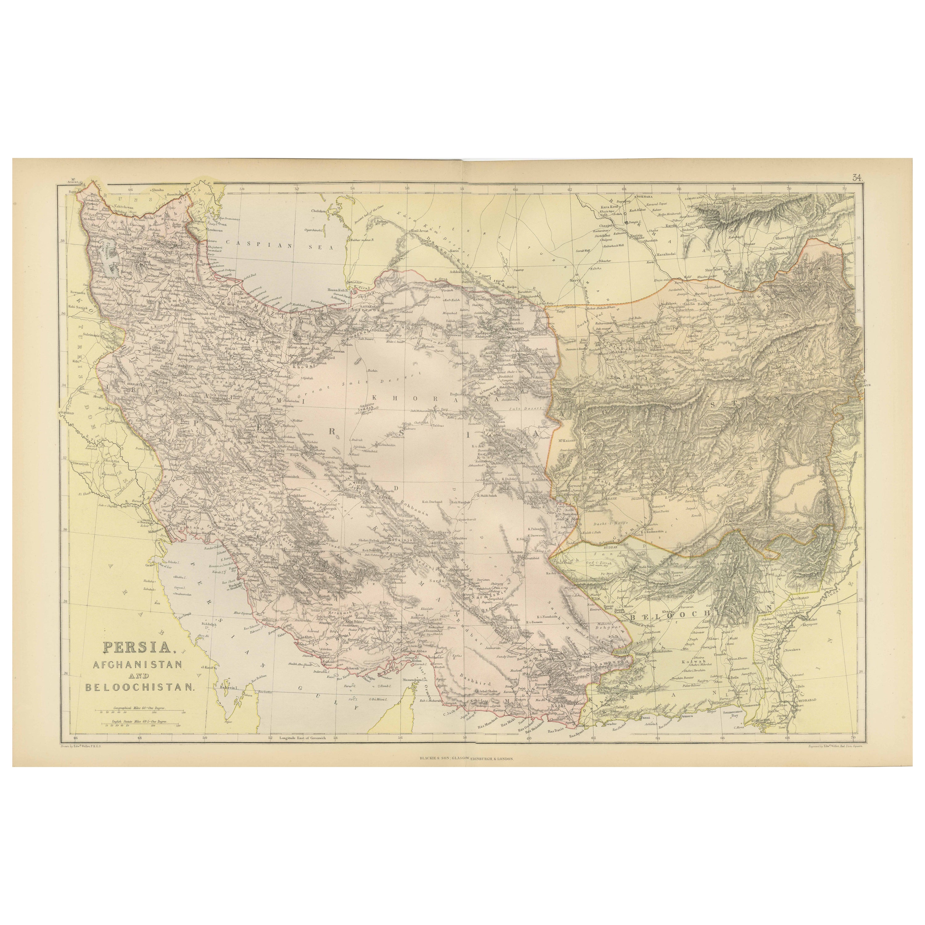
Oriental Realms: A Detailed Map of Persia, Afghanistan, and Beloochistan, 1882
Located in Langweer, NL
This historical map from the 1882 atlas published by Blackie & Son is a comprehensive depiction of Persia (modern-day Iran), Afghanistan, and Baluchistan (the region that includes pa...
Category
Antique 1880s English Maps
Materials
Paper

You May Also Like
Map of Persia - Original Etching - Late 19th Century
Located in Roma, IT
This Map of Persia is an etching realized by an anonymous artist.
The state of preservation of the artwork is good with some small diffused stains.
Sheet dimension: 25.5 x 44
At t...
Category
Late 19th Century Modern Figurative Prints
Materials
Etching
Large Original Vintage Map of Persia / Iran, circa 1920
Located in St Annes, Lancashire
Great maps of Persia.
Unframed.
Original color.
By John Bartholomew and Co. Edinburgh Geographical Institute.
Published, circa 1920.
Free shipping.
Category
Vintage 1920s British Maps
Materials
Paper

Large Original Antique Map of Afghanistan. Edward Weller, 1861
Located in St Annes, Lancashire
Great map of Afghanistan
Lithograph engraving by Edward Weller
Original colour
Published, 1861
Unframed
Good condition
Category
Antique 1860s English Victorian Maps
Materials
Paper

1851 Map of "Independent Tartary", Ric. R018
Located in Norton, MA
1851 Map of
Independent Tartary
"Russia"
Ric.r018
A highly decorative 1851 map of Independent Tartary by John Tallis and John Rapkin. Covers the regions between the Caspian Sea and Lake Bakquash and between Russia and Afghanistan. These include the ancient Silk Route kingdoms of Khiva, Tartaria, Kokand, and Bokhara. Today this region roughly includes Kazakhstan, Uzbekistan, Turkmenistan, Kyrgyzstan, and Tajikistan. This wonderful map offers a wealth of detail for anyone with an interest in the Central Asian portion of the ancient Silk Road. Identifies various caravan routes, deserts, wells, and stopping points, including the cities of Bokhara and Samarkand. Three vignettes by W. Bragg decorate the map, these including an image of Tartars on a Journey, a horseback Bride Chase, and a tartar camp site. Surrounded by a vine motif border. Engraved by J. Rapkin for John Tallis's 1851 Illustrated Atlas .
Tartary Antique Map...
Category
Antique 19th Century Unknown Maps
Materials
Paper

Persia
Afghanistan: A Framed Hand-colored 17th Century Map by John Cary
By John Cary
Located in Alamo, CA
This colorful and detailed early 18th century copperplate map by John Cary entitled "A New Map of Persia from the Latest Authorities" was published in London in 1801. It depicts Persia, the region of modern day Afghanistan, the Caspian Sea, the Sea of Aral, the Persian Gulf...
Category
Early 19th Century Old Masters More Prints
Materials
Engraving

Persia, Armenia
Adjacent Regions: A 17th Century Hand-colored Map by De Wit
By Frederick de Wit
Located in Alamo, CA
A large 17th century hand colored copperplate engraved map entitled "Novissima nec non Perfectissima Scandinaviae Tabula comprehendens Regnorum Sueciae, Daniae et Norvegiae distincte...
Category
Antique Late 17th Century Dutch Maps
Materials
Paper

More Ways To Browse
Antique Maps Persia
Antique Nautical Charts
Antique Macedonia
Hemispheres Map
Java Map
Miniature Maps
Antique Maps Of Wales
Swiss Antiques And Collectables
Map Stand
Caribbean Antique Furniture
West Indies Furniture
Railroad Collectibles
Antique Map Denmark
American West Furniture
Antique Railroad Collectibles
Gold Maps
World Map Of Trade Routes
J Walker