Items Similar to Antique Map of the Picardy Region of France by Ortelius,
circa 1590


Want more images or videos?
Request additional images or videos from the seller
1 of 5
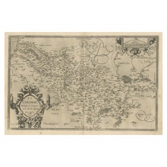
Antique Map of the Picardy Region of France by Ortelius,
circa 1590
$576.48
$720.6020% Off
£427.02
£533.7820% Off
€480
€60020% Off
CA$788.77
CA$985.9620% Off
A$858.24
A$1,072.8020% Off
CHF 454.43
CHF 568.0320% Off
MX$10,325.21
MX$12,906.5120% Off
NOK 5,770.21
NOK 7,212.7720% Off
SEK 5,279.34
SEK 6,599.1820% Off
DKK 3,657.99
DKK 4,572.4920% Off
About the Item
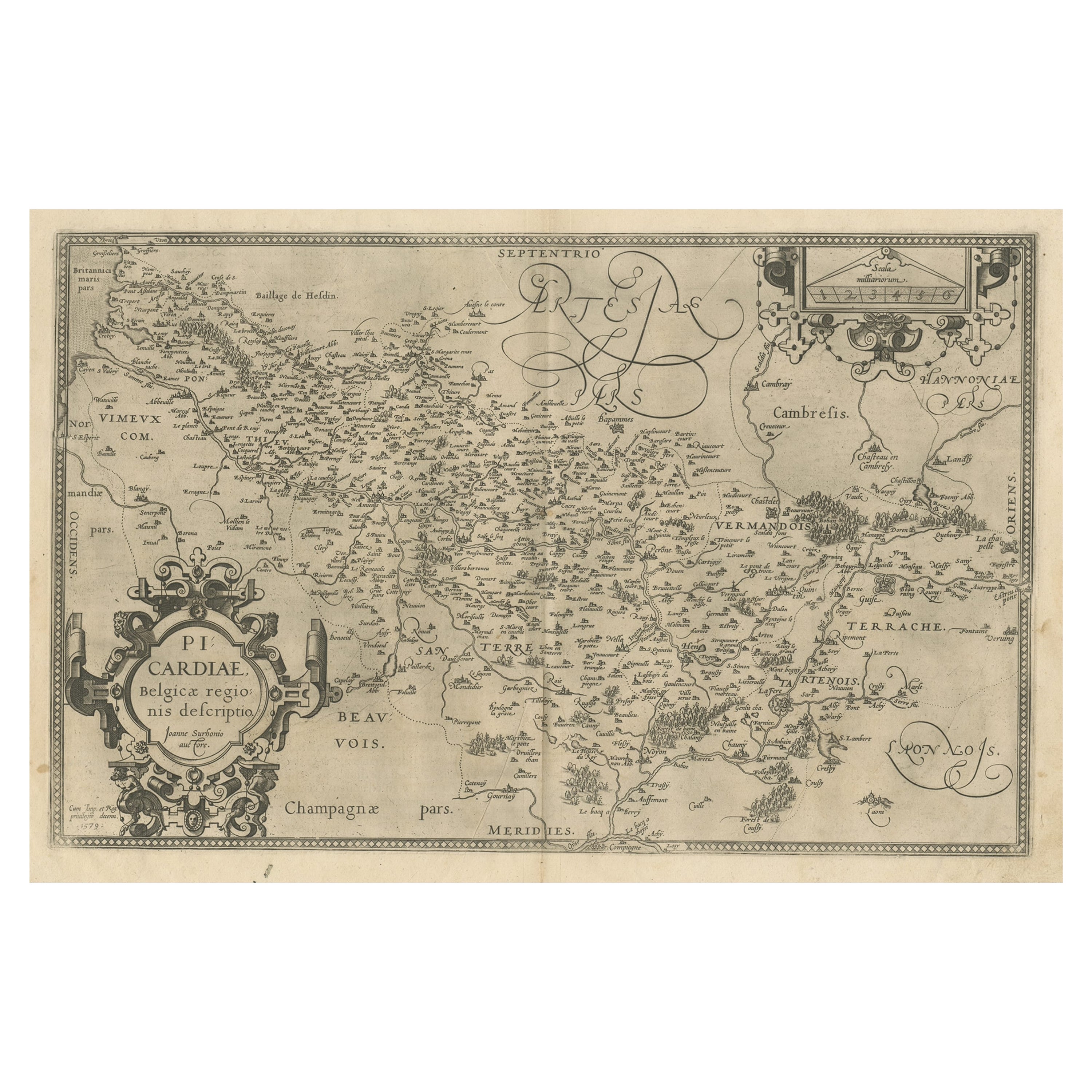
Antique map titled 'Picardiae Belgicae regionis descriptio'. Original antique map of the Picardy region, France. Published by A. Ortelius, circa 1590.
- Dimensions:Height: 15.36 in (39 cm)Width: 21.86 in (55.5 cm)Depth: 0.02 in (0.5 mm)
- Materials and Techniques:
- Period:
- Date of Manufacture:circa 1590
- Condition:Original/contemporary hand coloring. Latin text on verso. Genearl age-related toning, minor wear. Please study images carefully.
- Seller Location:Langweer, NL
- Reference Number:Seller: BG-12883-11stDibs: LU3054322270282
About the Seller
5.0
Recognized Seller
These prestigious sellers are industry leaders and represent the highest echelon for item quality and design.
Platinum Seller
Premium sellers with a 4.7+ rating and 24-hour response times
Established in 2009
1stDibs seller since 2017
2,816 sales on 1stDibs
Typical response time: 1 hour
- ShippingRetrieving quote...Shipping from: Langweer, Netherlands
- Return Policy
More From This Seller
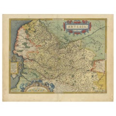
View AllAntique Map of the Artois Region of France by Ortelius,
circa 1590
Located in Langweer, NL
Antique map titled 'Artesia'. Original antique map of the Artois region, France. Published by A. Ortelius, circa 1590.
Category
Antique 16th Century Maps
Materials
Paper
$576 Sale Price
20% Off
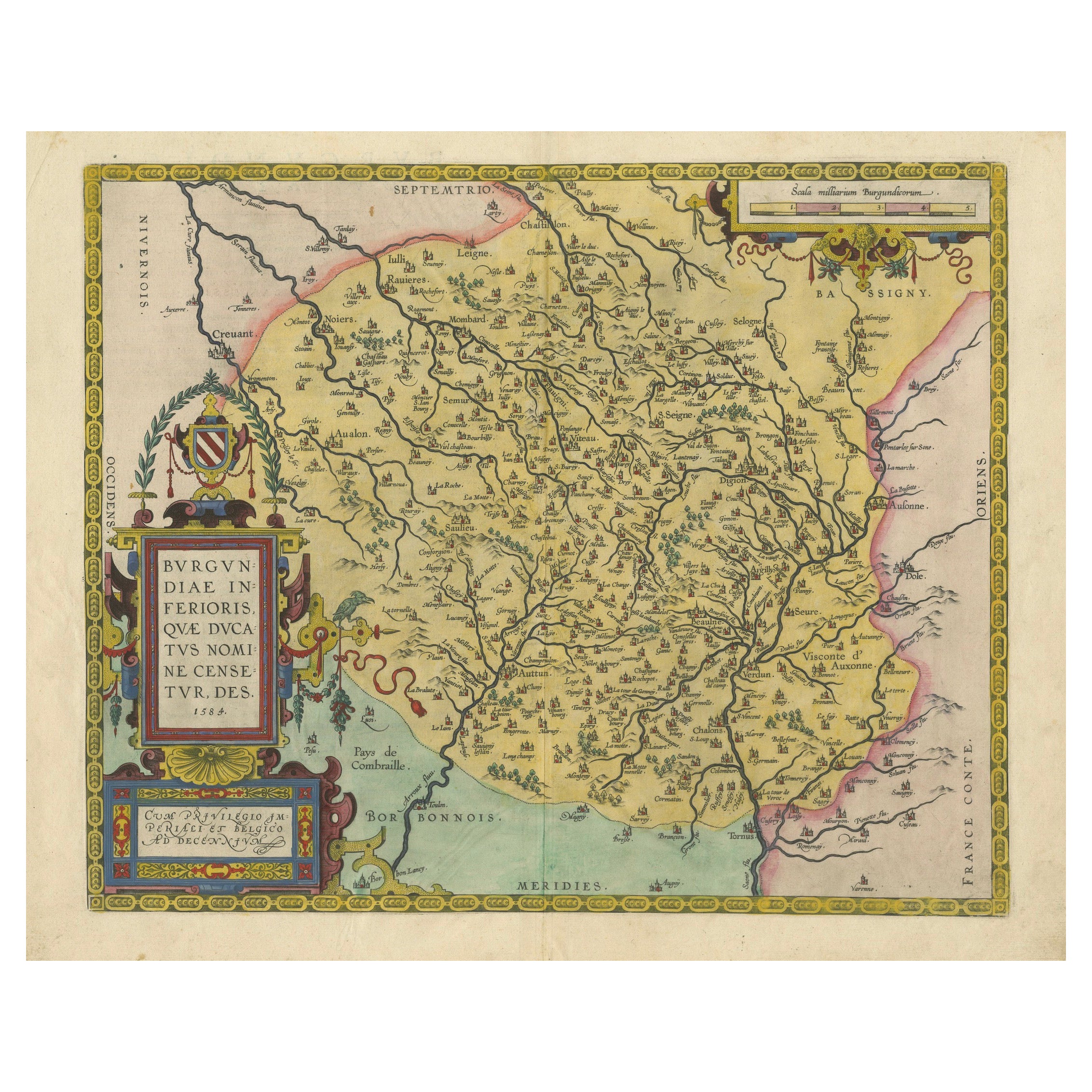
1584 Abraham Ortelius Map of Lower Burgundy, France
Located in Langweer, NL
1584 Abraham Ortelius Map of Lower Burgundy, France
Description of the Map:
This antique map by Abraham Ortelius, titled "Bvrgvndiae Inferioris Qvae Dvcatvs Nomine Censetur Des," w...
Category
Antique 16th Century Maps
Materials
Paper
$1,220 Sale Price
20% Off
Antique Map of the Region of Poitou by Ortelius, circa 1600
Located in Langweer, NL
Antique map titled 'Poictou'. Original antique map of the region of Poitou, a former province of west-central France whose capital city was Poitiers. Published by A. Ortelius, circa ...
Category
Antique Early 17th Century Maps
Materials
Paper

$576 Sale Price
20% Off
Antique Map of the Region of Boulogne and Peronne, France
C.1590
Located in Langweer, NL
Antique map titled 'Caletensium et Bononiensium (..)'.
Two detailed regional maps on one sheet. The first map shows Belgian and French Coastal region, from Estaples to Gruerlinge...
Category
Antique 16th Century Maps
Materials
Paper

$470 Sale Price
20% Off
Antique Map of the Region of Bourbonnais by Janssonius, circa 1640
Located in Langweer, NL
Antique map titled 'Bourbonois - Borbonium Ducatus'. Old map of the former region of Bourbonnais, France. It includes the cities of Bourbon, Moulins, Charenton, Brulles, Varennes and...
Category
Antique Mid-17th Century Maps
Materials
Paper

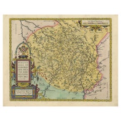
Original Antique Map of the Region of Picardy, France, ca.1602
Located in Langweer, NL
Antique map titled 'Picardiae Belgicae regionis descriptio'.
Original antique map of the region of Picardy, France. Superb example of the decorative style of Ortelius and filled ...
Category
Antique Early 1600s Maps
Materials
Paper
$624 Sale Price
20% Off
You May Also Like
17th Century Hand-Colored Map of a Region in West Germany by Janssonius
By Johannes Janssonius
Located in Alamo, CA
This attractive highly detailed 17th century original hand-colored map is entitled "Archiepiscopatus Maghdeburgensis et Anhaltinus Ducatus cum terris adjacentibus". It was published ...
Category
Antique Mid-17th Century Dutch Maps
Materials
Paper

$1,020 Sale Price
20% Off
1590 Ortelius Map of Calais and Vermandois, France and Vicinity Ric.a014
Located in Norton, MA
1590 Ortelius map of
Calais and Vermandois, France and Vicinity
Ric.a014
Two rare regional Abraham Ortelius maps on a single folio sheet. Left map, entitled Caletensium, depic...
Category
Antique 16th Century Dutch Maps
Materials
Paper

1590 Mercator Map Entitled "France Picardie Champaigne, Ric.0001
Located in Norton, MA
Description: Published in Amsterdam by Mercator/Hondius ca. 1590.
Ric.0001
Artists and Engravers: Map : 'France Picardie Champaigne cum regionibus adiacentibus'. (Map of the french provinces of Picardie and Champagne.) Copper engraved map of the french provinces of Picardie and Champagne, showing the cities of Caen, Paris, Melun, Auxerre, Verdun, etc. Copperplate engraving on verge type hand laid paper with watermark. Description: Published in Amsterdam by Mercator/Hondius ca. 1600.Artists and Engravers: Mercator was born in Rupelmonde in Flanders and studied in Louvain under Gemma Frisius, Dutch writer, astronomer and mathematician. The excellence of his work brought him the patronage of Charles V, but in spite of his favor with the Emperor he was caught up in the persecution of Lutheran protestants and charged with heresy, fortunately without serious consequences. No doubt the fear of further persecution influenced his move in 1552 to Duisburg, where he continued the production of maps, globes and instruments. Mercator's sons and grandsons, were all cartographers and made their contributions in various ways to his atlas. Rumold, in particular, was responsible for the complete edition in 1595. The map plates...
Category
Antique 16th Century Dutch Maps
Materials
Paper

1625 Mercator Map of the Provenience of Quercy, "Quercy Cadvrcivm Ric.0013
Located in Norton, MA
1625 Mercator map of the provenience of Quercy, entitled
"Quercy Cadvrcivm,"
Ric.0013
" Authentic" - Map of the provenience of Quercy Cadvrcivm
D...
Category
Antique 17th Century French Maps
Materials
Paper

1656 Jansson Map Metz Region of France Entitled "Territorium Metense" Ric0014
Located in Norton, MA
1656 Jansson map Metz Region of France entitled "Territorium Metense."
Ric0014
" Authentic" - Map of the historical region surrounding Metz, in Lorraine, France.
Oriented with ...
Category
Antique 17th Century Dutch Maps
Materials
Paper

1630 Pierre Petit map "Description du Gouvernement de la Capelle" Ric0010
Located in Norton, MA
1630 Pierre Petit map entitled
"Description du Gouvernement de la Capelle,"
Ric0010
Pierre Petit was the son of a minor provincial official in Montluçon. The town, in the Auver...
Category
Antique 17th Century Dutch Maps
Materials
Paper

More Ways To Browse
Antique Map Ortelius
West Indies Furniture
Railroad Collectibles
Antique Map Denmark
American West Furniture
Antique Railroad Collectibles
Gold Maps
World Map Of Trade Routes
J Walker
Mercator Map
Antique Map Of Switzerland
Albanian Antique
Antique Pamphlets
Antique Mediterranean Map
Antique Map Mexico
Antique Map Paris
Antique Puerto Rico
West Indies Antique Furniture