Items Similar to Antique Map of present-day North-Rhine Westphalia, Germany


Want more images or videos?
Request additional images or videos from the seller
1 of 6
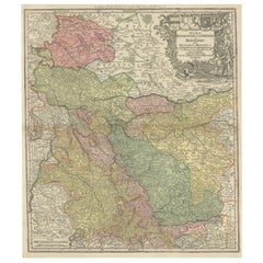
Antique Map of present-day North-Rhine Westphalia, Germany
$505.24
$631.5520% Off
£376.33
£470.4120% Off
€424
€53020% Off
CA$695.75
CA$869.6920% Off
A$757.31
A$946.6320% Off
CHF 401.27
CHF 501.5920% Off
MX$9,107.77
MX$11,384.7120% Off
NOK 5,102.05
NOK 6,377.5620% Off
SEK 4,675.46
SEK 5,844.3320% Off
DKK 3,230.60
DKK 4,038.2520% Off
About the Item
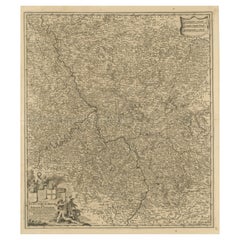
Antique map titled 'Nova et Accurata Ducatus Cliviae et Comitatus Marchiae (..)'. Detailed regional map of Germany showing the region bounded by the Maas River in the west and to part of Westphalia in the East. The map is centered on the Rhine region from Cologne to Arnheim, and showing Cleef, Nidwesel, Rheinbergen, Duisberg, Dusseldorf, Munster, etc. Nice decorative cartouche. Published by M. Seutter.
Matthäus Seutter (1678-1757) was a prominent German mapmaker in the mid-eighteenth century. Initially apprenticed to a brewer, he trained as an engraver under Johann Baptist Homann in Nuremburg before setting up shop in his native Augsburg. In 1727 he was granted the title Imperial Geographer. His most famous work is Atlas Novus Sive Tabulae Geographicae, published in two volumes ca. 1730, although the majority of his maps are based on earlier work by other cartographers like the Homanns, Delisles, and de Fer.
- Dimensions:Height: 21.66 in (55 cm)Width: 25.52 in (64.8 cm)Depth: 0.02 in (0.5 mm)
- Materials and Techniques:
- Period:
- Date of Manufacture:c.1750
- Condition:Repaired: Professional restorations on both bottom corners. General age-related toning. Shows some wear and soiling. Original folding line with large split, but still attached. Professional restorations on both bottom corners. Few small defects in margins. Blank verso. Please study image carefully.
- Seller Location:Langweer, NL
- Reference Number:Seller: BG-13442-171stDibs: LU3054335045782
About the Seller
5.0
Recognized Seller
These prestigious sellers are industry leaders and represent the highest echelon for item quality and design.
Platinum Seller
Premium sellers with a 4.7+ rating and 24-hour response times
Established in 2009
1stDibs seller since 2017
2,824 sales on 1stDibs
Typical response time: 1 hour
- ShippingRetrieving quote...Shipping from: Langweer, Netherlands
- Return Policy
More From This Seller
View AllAntique Map of the Westphalia region of Germany
Located in Langweer, NL
Antique map titled 'Circulus Westphaliae (..)'. Original old map of the Westphalia region, Germany. Published by Justus Danckerts, circa 1696.
Justus Danckerts I (11 November 1635 ...
Category
Antique Late 17th Century Maps
Materials
Paper

Antique Map of the Niederrhein region, Germany
Located in Langweer, NL
Antique map titled 'Circulus Electorum Rheni sive Rhenanus Inferior (..)'. Original antique map of the Niederrhein region, Germany. By F. de Wit, circa 1690.
Frederick de Wit (1629-...
Category
Antique Late 17th Century Maps
Materials
Paper
$428 Sale Price
20% Off
Antique Map of Western Germany with part of the Netherlands
Located in Langweer, NL
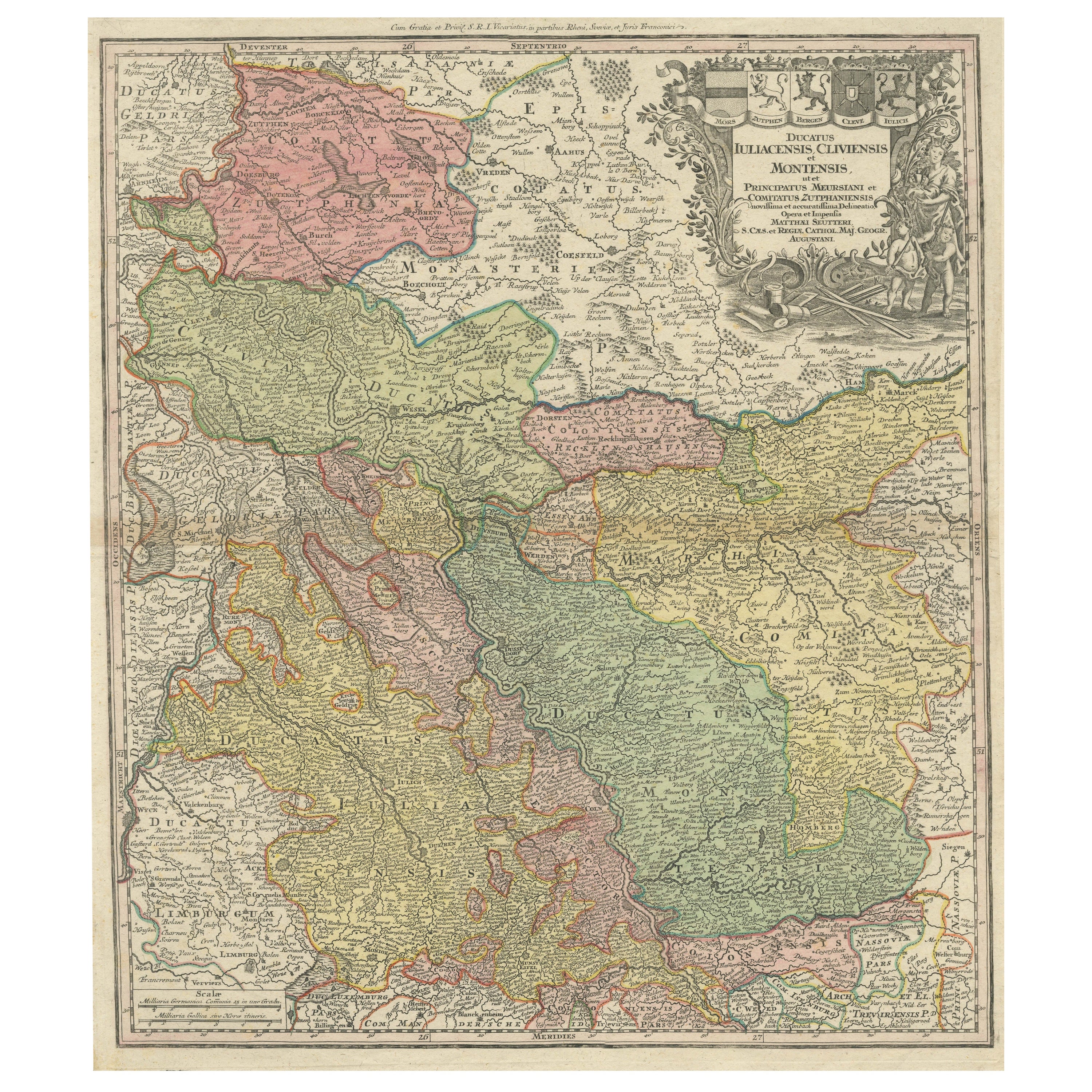
Antique map titled 'Ducatus Iuliacensis Cliviensis et Montensis (..)'. Original old map of Western Germany with part of the Netherlands. Published by M. Seutter, circa 1750.
George...
Category
Antique Mid-18th Century Maps
Materials
Paper
$428 Sale Price
20% Off
Detailed Antique Map of the Lower Rhine region, Germany
Located in Langweer, NL
Antique map titled 'S.R.I. Circulus Rhanus Inferior sive Electorum Rheni (..)'. Detailed map of the Lower Rhine region, Germany. The title cartouche in the upper left quadrant featur...
Category
Antique Mid-18th Century Maps
Materials
Paper

$428 Sale Price
20% Off
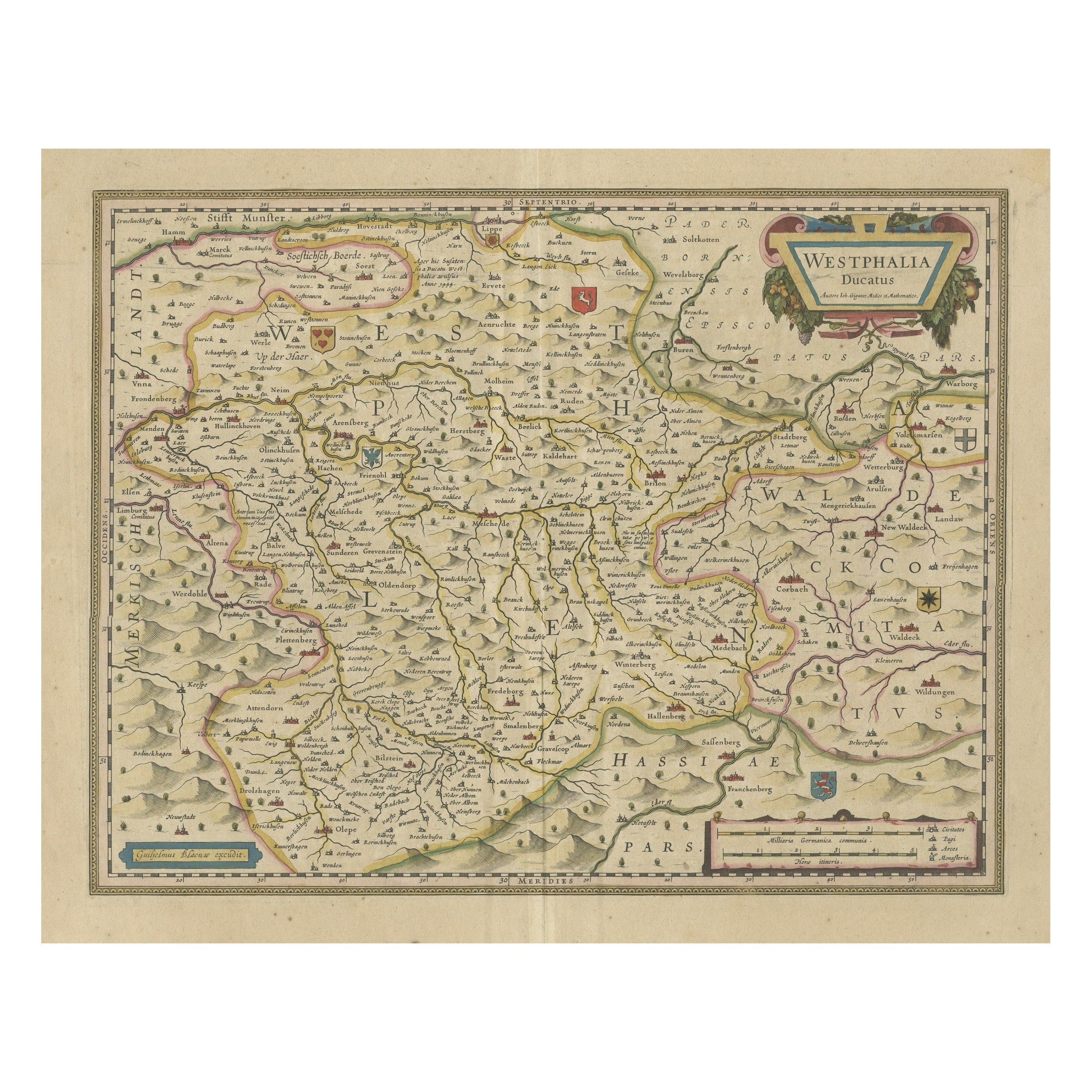
Antique Map of the Duchy of Westphalia, Germany
Located in Langweer, NL
Original antique map titled 'Westphalia Ducatus'. Fine map of the Duchy of Westphalia, Germany. The map is centered on Meschede and includes Arensberg, Beelick, and Brilon. Published...
Category
Antique Mid-17th Century Maps
Materials
Paper
$705 Sale Price
20% Off
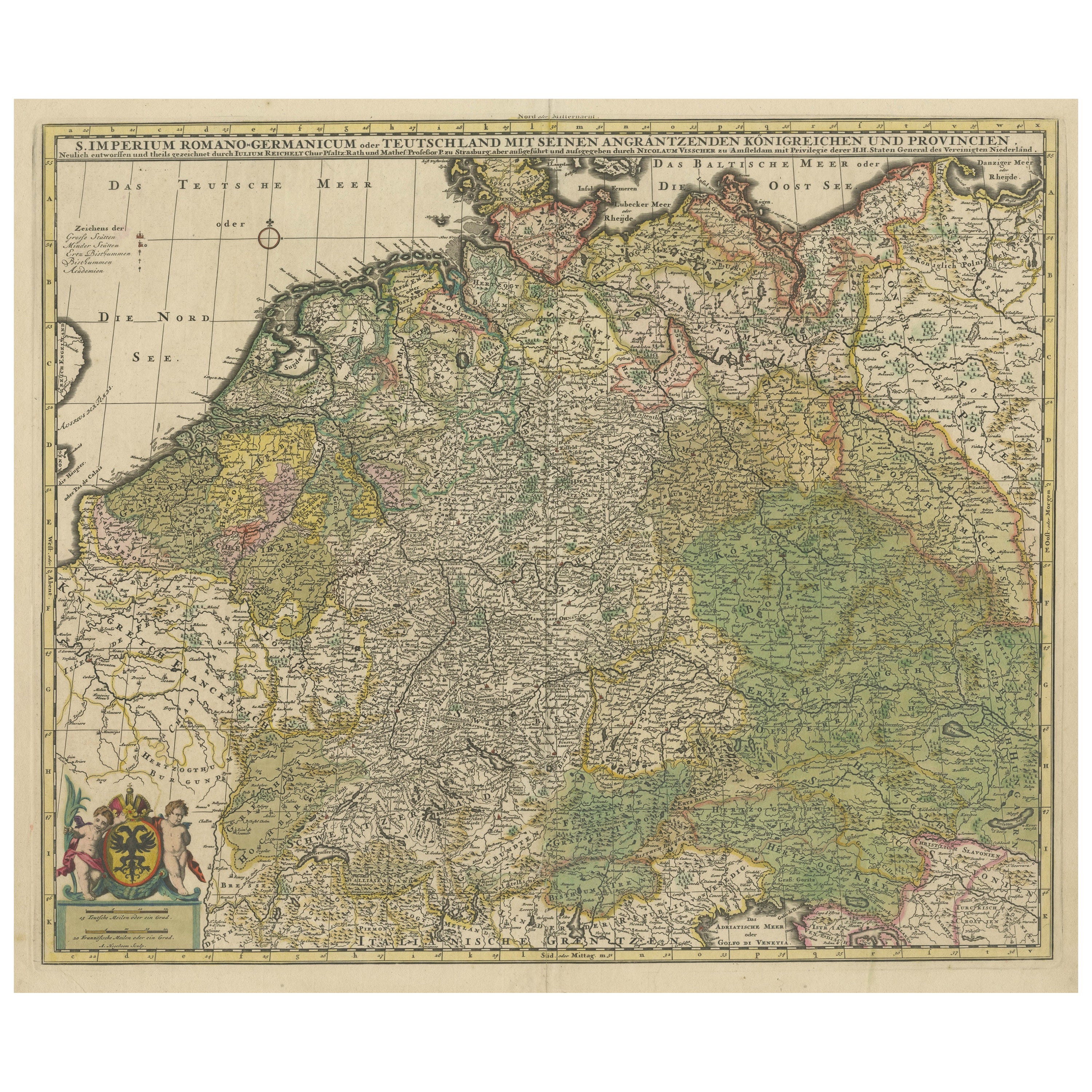
Antique Map of Germany and Central Europe, ca.1690
Located in Langweer, NL
Antique map titled 'S. Imperium Romano-Germanicum oder Teutschland mit seinen angrantzenden Königreichen und Provincien'. Original antique map of Germany...
Category
Antique Late 17th Century Dutch Maps
Materials
Paper

$1,048 Sale Price
20% Off
You May Also Like
17th Century Hand-Colored Map of a Region in West Germany by Janssonius
By Johannes Janssonius
Located in Alamo, CA
This attractive highly detailed 17th century original hand-colored map is entitled "Archiepiscopatus Maghdeburgensis et Anhaltinus Ducatus cum terris adjacentibus". It was published ...
Category
Antique Mid-17th Century Dutch Maps
Materials
Paper

Prussia, Poland, N. Germany, Etc: A Hand-colored 17th Century Map by Janssonius
By Johannes Janssonius
Located in Alamo, CA
This is an attractive hand-colored copperplate engraved 17th century map of Prussia entitled "Prussia Accurate Descripta a Gasparo Henneberg Erlichensi", published in Amsterdam by Joannes Janssonius in 1664. This very detailed map from the golden age of Dutch cartography includes present-day Poland, Latvia, Lithuania, Estonia and portions of Germany. This highly detailed map is embellished by three ornate pink, red, mint green and gold...
Category
Antique Mid-17th Century Dutch Maps
Materials
Paper

17th Century Nicolas Visscher Map of Southeastern Europe
Located in Hamilton, Ontario
A beautiful, highly detailed map of southeastern Europe by Nicolas Visscher. Includes regions of Northern Italy (showing the cities Bologna, Padua, and Venice), Bohemia, Austria (sho...
Category
Antique 17th Century Dutch Maps
Materials
Paper

$1,350 Sale Price
38% Off
German Empire, Northern Part. Century Atlas antique vintage map
Located in Melbourne, Victoria
'The Century Atlas. German Empire, Northern Part.'
Original antique map, 1903.
Central fold as issued. Map name and number printed on the reverse corne...
Category
Early 20th Century Victorian More Prints
Materials
Lithograph

Austria-Hungary, Western Part. Century Atlas antique vintage map
Located in Melbourne, Victoria
'The Century Atlas. Austria-Hungary, Western Part'
Original antique map, 1903.
Central fold as issued. Map name and number printed on the reverse corners.
Sheet 40cm by 29.5cm.
Category
Early 20th Century Victorian More Prints
Materials
Lithograph

1853 Map of "Russia in Europe Including Poland" Ric.r016
Located in Norton, MA
Description
Russia in Europe incl. Poland by J Wyld c.1853
Hand coloured steel engraving
Dimension: Paper: 25 cm W x 33 cm H ; Sight: 22 cm W x 28 cm H
Condition: Good ...
Category
Antique 19th Century Unknown Maps
Materials
Paper

More Ways To Browse
Antique German 18th Century
Vintage Long Island Map
Vintage World Map Desk
Vintage World Map Mirror
Antique Furniture Toledo Ohio
Antique Maps Washington Dc
Blaeu World Map
Cape Cod Map
F Colton
Irish Antiques 16th Century
Ithaca Antique Map
Leonard Jones
Russia Globe
Salt Lake City Used Furniture
World Map Copper
Luxury Modern Carpet
French Directoire Furniture
French Earthenware