Items Similar to Antique Map of the Province of Zeeland, The Netherlands by Coronelli, 1692


Want more images or videos?
Request additional images or videos from the seller
1 of 5
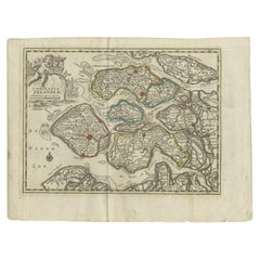
Antique Map of the Province of Zeeland, The Netherlands by Coronelli, 1692
$804.60
£595.93
€670
CA$1,100.65
A$1,197.85
CHF 634.98
MX$14,411.05
NOK 8,053.57
SEK 7,368.46
DKK 5,105.52
About the Item
Antique map titled 'Contado di Zelanda'. Beautiful map of the Dutch province of Zeeland. With the islands of Walcheren, Schouwen-Duiveland, Noord-Beveland, Zuid-Beveland, Tholen and Zeeuws Vlaanderen. On the map, among other things, Vlissingen, Middelburg, Veere, Goes, Tholen, Zierikzee Domburg, Sluis and Terneuzen.
Artists and Engravers: Published in Venice by V. Coronelli. The remarkable Vincenzo Coronelli (1650-1718), encyclopaedist, geographer, inventor and Doctor of Theology, was citizen of the Republic of Venice. He was also one of the most prominent mapmakers and publishers in Europe of his day.
Condition: Very good, please study image carefully.
Date: 1692
Overall size: 68 x 48 cm.
Image size: 60 x 46 cm.
We sell original antique maps to collectors, historians, educators and interior decorators all over the world. Our collection includes a wide range of authentic antique maps from the 16th to the 20th centuries. Buying and collecting antique maps is a tradition that goes back hundreds of years. Antique maps have proved a richly rewarding investment over the past decade, thanks to a growing appreciation of their unique historical appeal. Today the decorative qualities of antique maps are widely recognized by interior designers who appreciate their beauty and design flexibility. Depending on the individual map, presentation, and context, a rare or antique map can be modern, traditional, abstract, figurative, serious or whimsical. We offer a wide range of authentic antique maps for any budget.
- Dimensions:Height: 18.9 in (48 cm)Width: 26.78 in (68 cm)Depth: 0 in (0.01 mm)
- Materials and Techniques:
- Period:
- Date of Manufacture:1692
- Condition:Condition: Very good, please study image carefully.
- Seller Location:Langweer, NL
- Reference Number:Seller: BGJC-002451stDibs: LU3054327827552
About the Seller
5.0
Recognized Seller
These prestigious sellers are industry leaders and represent the highest echelon for item quality and design.
Platinum Seller
Premium sellers with a 4.7+ rating and 24-hour response times
Established in 2009
1stDibs seller since 2017
2,813 sales on 1stDibs
Typical response time: 1 hour
- ShippingRetrieving quote...Shipping from: Langweer, Netherlands
- Return Policy
More From This Seller
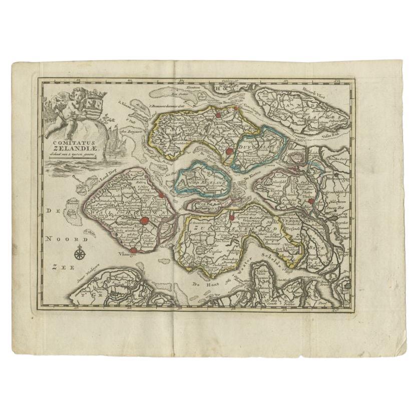
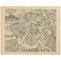
View AllAntique Map of the Province of Zeeland by Keizer
De Lat, 1788
Located in Langweer, NL
Antique map titled 'Comitatus Zelandiae'. Uncommon antique map of the province of Zeeland, the Netherlands. This map originates from 'Nieuwe Natuur- Geschied- en Handelkundige Zak- e...
Category
Antique 18th Century Maps
Materials
Paper
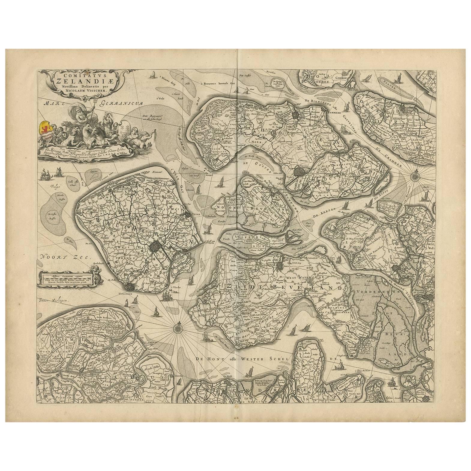
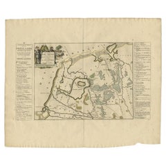
Antique Map of Zeeland
The Netherlands
by N. Visscher, circa 1690
Located in Langweer, NL
Antique map titled 'Comitatus Zelandiae (..)'. Detailed chart of the province Zeeland, The Netherlands, with details shown pictorially. Published by N. Visscher.
Category
Antique Late 17th Century Maps
Materials
Paper
$634 Sale Price
20% Off
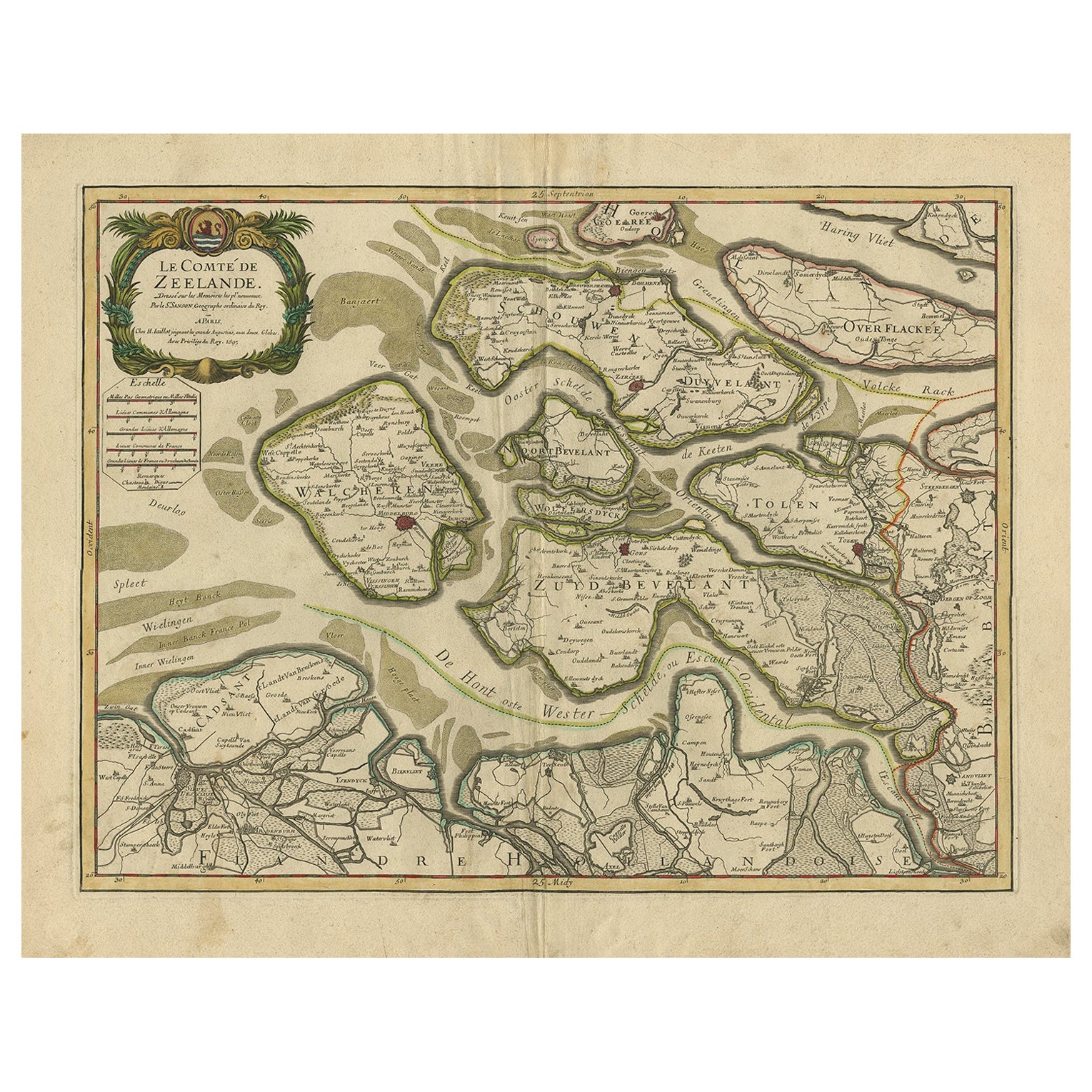
Antique Map of Zeeland, The Netherlands, by Jaillot, 1693
Located in Langweer, NL
Antique map titled 'Le Comte de Zeelande (..).' Detailed map of the province of Zeeland, The Netherlands. Details shown include fortified towns, roads, sandbanks and marshlands. Base...
Category
Antique 17th Century Maps
Materials
Paper

$855 Sale Price
20% Off
Antique Map of the Province of Friesland in The Netherlands, 1718
Located in Langweer, NL
Antique map titled 'Frisiae Dominium vernacule Friesland (..)'.
Original antique map of Friesland, the Netherlands. Originates from 'Uitbeelding van de Heerlijkheid van Friesland...
Category
Antique 18th Century Maps
Materials
Paper

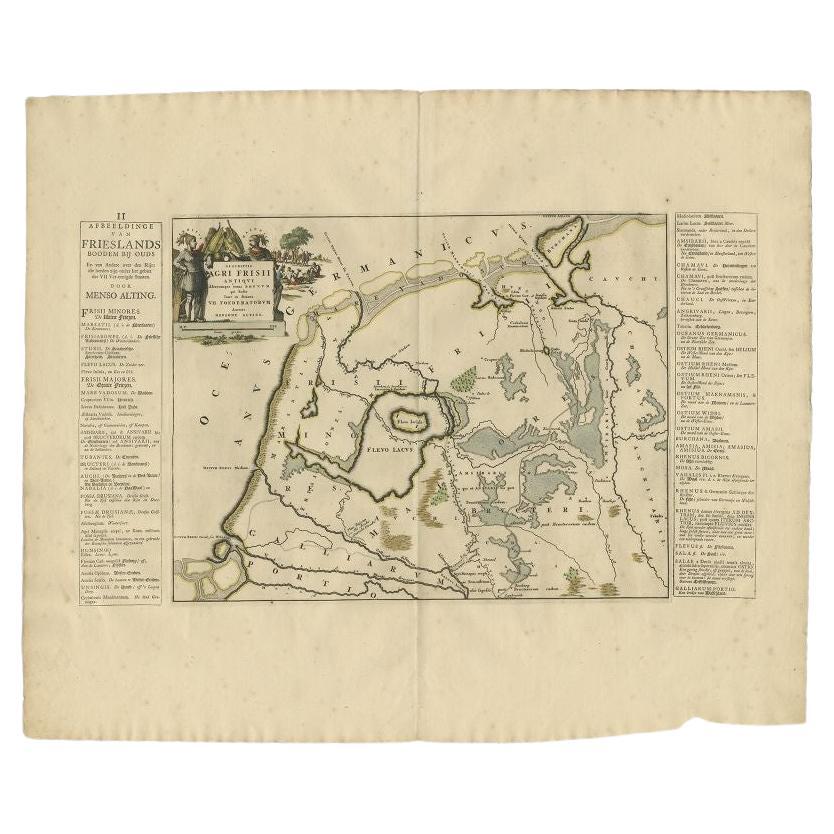
Antique Map of the Old Lands of FriesLand by Halma, 1718
Located in Langweer, NL
Antique map Friesland titled 'Descriptio Agri Frisii (..)'. Old map of Friesland, the Netherlands. This map depicts the old lands of Friesland. Originates from 'Uitbeelding van de He...
Category
Antique 18th Century Maps
Materials
Paper
Antique Map of Friesland by De Wit, c.1690
Located in Langweer, NL
Antique map titled 'Tabula Comitatus Frisiae'.
Old map of the province of Friesland, the Netherlands. With a small inset map of the Wadden area. Third state of the map by Schotan...
Category
Antique 17th Century Maps
Materials
Paper

You May Also Like
1752 Vaugoundy Map of Flanders : Belgium, France, and the Netherlands, Ric.a002
Located in Norton, MA
Large Vaugoundy Map of Flanders:
Belgium, France, and the Netherlands
Colored -1752
Ric.a002
Description: This is a 1752 Didier Robert de Vaugondy map of Flanders. The map de...
Category
Antique 17th Century Unknown Maps
Materials
Paper

1643 Willem&Joan Blaeu Map NW Flanders "Flandriae Teutonicae Pars Prientalior
Located in Norton, MA
1643 Willem and Joan Blaeu map of northwest Flanders, entitled
"Flandriae Teutonicae Pars Prientalior,"
Ric0012
" Authentic" - Map of the northwest Fl...
Category
Antique 17th Century Dutch Maps
Materials
Paper

1646 Jansson Map Entitled "Procinvia Connactiae, " Ric.a006
Located in Norton, MA
1646 Jansson map entitled
"Procinvia connactiae,"
Ric.a006
Description: The PROVINCE of CONNAVGT 490 x 380From vol 4 of Jansson's Atlas Novus 1646, published in Amsterdam with...
Category
Antique 17th Century Unknown Maps
Materials
Paper

17th Century Hand Colored Map of the Liege Region in Belgium by Visscher
By Nicolaes Visscher II
Located in Alamo, CA
An original 17th century map entitled "Leodiensis Episcopatus in omnes Subjacentes Provincias distincté divisusVisscher, Leodiensis Episcopatus" by Nicolaes Visscher II, published in Amsterdam in 1688. The map is centered on Liege, Belgium, includes the area between Antwerp, Turnhout, Roermond, Cologne, Trier and Dinant.
This attractive map is presented in a cream-colored mat measuring 30" wide x 27.5" high. There is a central fold, as issued. There is minimal spotting in the upper margin and a tiny spot in the right lower margin, which are under the mat. The map is otherwise in excellent condition.
The Visscher family were one of the great cartographic families of the 17th century. Begun by Claes Jansz Visscher...
Category
Antique Late 17th Century Dutch Maps
Materials
Paper

$940 Sale Price
20% Off
Hand-Colored 18th Century Homann Map of Denmark and Islands in the Baltic Sea
By Johann Baptist Homann
Located in Alamo, CA
An 18th century copper plate hand-colored map entitled "Insulae Danicae in Mari Balthico Sitae utpote Zeelandia, Fionia, Langelandia, Lalandia, Falstria, Fembria Mona" created by Joh...
Category
Antique Early 18th Century German Maps
Materials
Paper

$620 Sale Price
20% Off
Ancient Map - Zeilan - Etching by Johannes Janssonius - 1650s
By Johannes Janssonius
Located in Roma, IT
Ancient Map - Zeilan is an ancient map realized in 1650 by Johannes Janssonius (1588-1664).
The Map is Hand-colored etching, with coeval watercoloring.
...
Category
1650s Modern Figurative Prints
Materials
Etching

More Ways To Browse
Antique Map Of Cuba
Antique Map Vietnam
Antique Maps Colorado
Antique Maps Of Kansas
Antique Marine Maps
Antique World Globe Map
Garde Corps
Marie Galante
Nevada Antique Map
Nova Scotia Antique Furniture
Patagonia Map
Antique Furniture South Carolina
Antique Map Of Boston
Antique Map Of Venice
Antique Maps Of Maryland
Charlotte Reine
Cleveland Antique Furniture
Gambia Antique Map