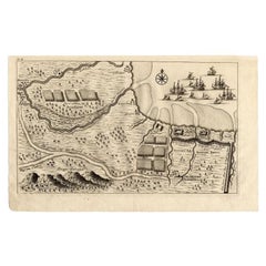
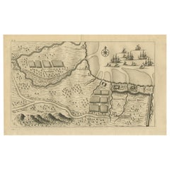
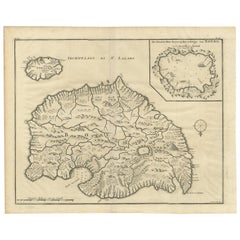
Items Similar to Antique Map of the Region aroud Pasuruan
Indonesia
by F. Valentijn, 1726
Want more images or videos?
Request additional images or videos from the seller
1 of 10
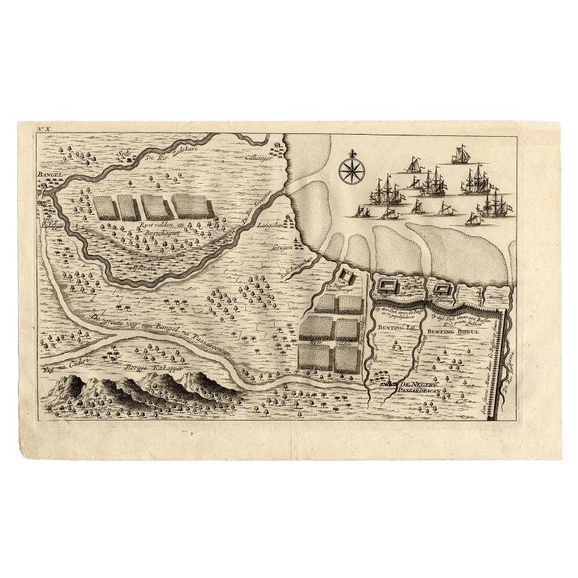
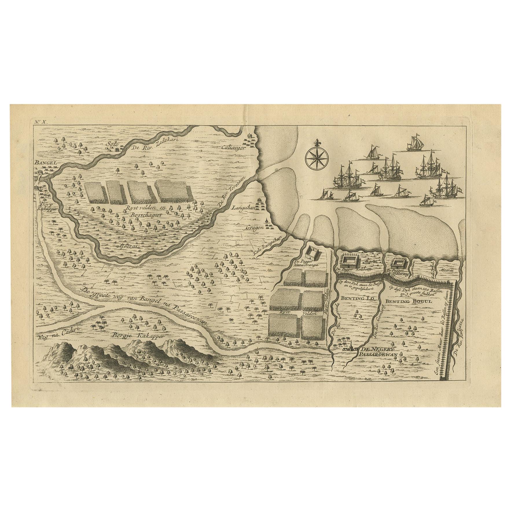
Antique Map of the Region aroud Pasuruan
Indonesia
by F. Valentijn, 1726
On Hold
$239.10
On Hold
£178.44
On Hold
€200
On Hold
CA$329.82
On Hold
A$360.77
On Hold
CHF 189.95
On Hold
MX$4,307.19
On Hold
NOK 2,420.98
On Hold
SEK 2,214.62
On Hold
DKK 1,523.67
About the Item
Map of the region around Pasuruan. It shows the location of rice fields, the village Bangil, as well as three places named Pagger (also Pagar), a cluster of buildings surrounded by a bamboo fence. The location of a earthen wall with pallisade and small cannons (Bas) is also given. From the monumental: "Oud en Nieuw Oost-Indiën ..." by François Valentyn / Valentijn, published in 1724-1726. VOC.
- Dimensions:Height: 7.8 in (19.8 cm)Width: 13 in (33 cm)Depth: 0.02 in (0.5 mm)
- Materials and Techniques:
- Place of Origin:
- Period:
- Date of Manufacture:1726
- Condition:Minor fading. Good. Please study image carefully.
- Seller Location:Langweer, NL
- Reference Number:Seller: BG-094231stDibs: LU3054310070041
About the Seller
5.0
Recognized Seller
These prestigious sellers are industry leaders and represent the highest echelon for item quality and design.
Platinum Seller
Premium sellers with a 4.7+ rating and 24-hour response times
Established in 2009
1stDibs seller since 2017
2,810 sales on 1stDibs
Typical response time: <1 hour
- ShippingRetrieving quote...Shipping from: Langweer, Netherlands
- Return Policy
More From This Seller
View AllAntique Map of the Region of Pasuruan, Java, Indonesia, 1726
Located in Langweer, NL
"Map of the region around Pasuruan. It shows the location of rice fields, the village Bangil, as well as three places named Pagger (also Pagar), a cluster of buildings surrounded by a bamboo fence. The location of a earthen wall with pallisade and small cannons...
Category
Antique 18th Century Maps
Materials
Paper
Antique Print of the Region around Pasuruan Indonesia by Valentijn, 1726
Located in Langweer, NL
Antique print of the region around Pasuruan near Surabaya, Indonesia. It shows the location of rice fields, the village Bangil, as well as three places named Pagger (also Pagar), a cluster of buildings surrounded by a bamboo fence. The location of a earthen wall with pallisade and small cannons...
Category
Antique Mid-18th Century Dutch Prints
Materials
Paper
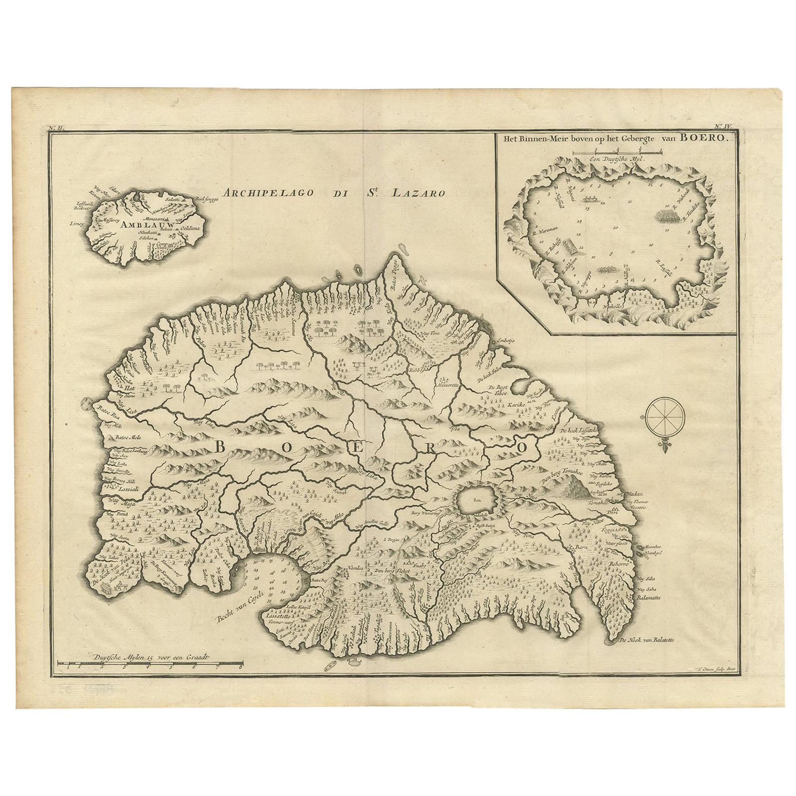
Antique Map of Boero in Indonesia by Valentijn, 1726
By F. Valentijn
Located in Langweer, NL
Antique map titled 'Boero-Amblauw'. Detailed map of the Island Ambelau and Buru, Maluku Islands, Indonesia. With an inset of the lake on the Buru mountains. This print originates fro...
Category
Antique Early 18th Century Dutch Maps
Materials
Paper
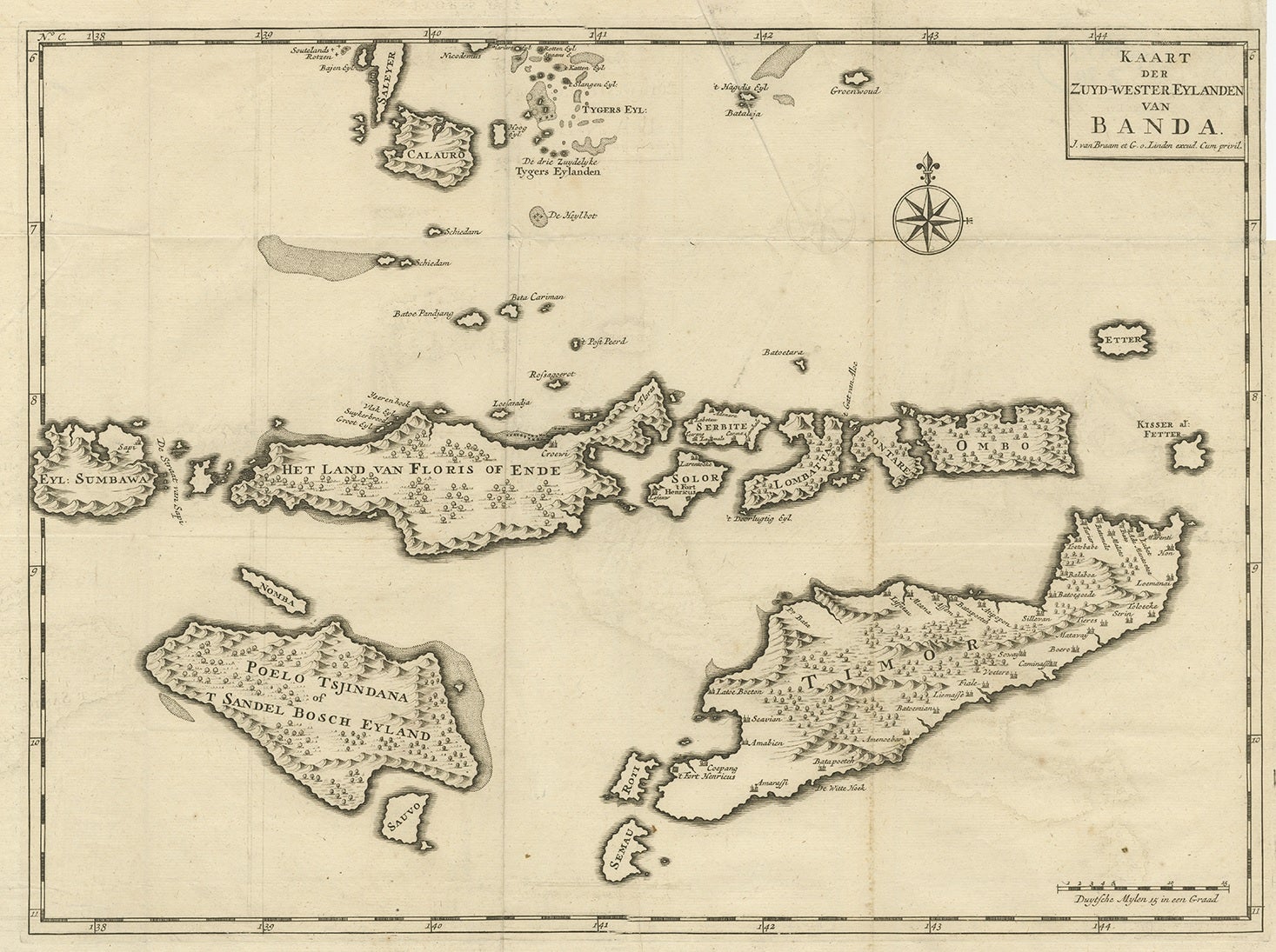
Antique Map of the Banda Islands in Indonesia by Valentijn, 1726
Located in Langweer, NL
Antique map Indonesia titled 'Kaart der Zuyd-Wester Eylanden van Banda'. Map of the islands in the southwestern part of the Banda Sea including ...
Category
Antique Mid-18th Century Dutch Maps
Materials
Paper
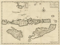
$478 Sale Price
20% Off
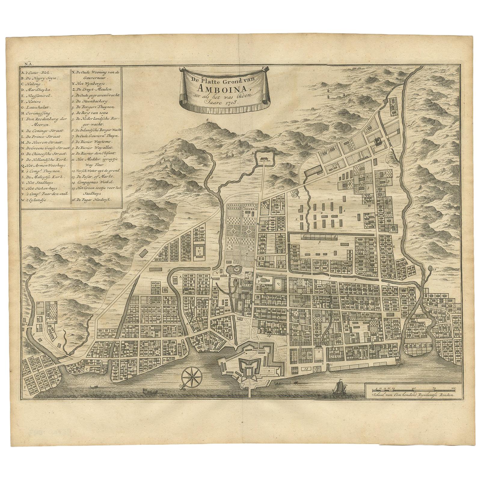
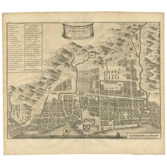
Antique Map of the City of Ambon by Valentijn, 1726
By F. Valentijn
Located in Langweer, NL
Antique map titled 'De Platte Grond van Amboina zoo als het was in den Jaare, 1718'. Antique map depicting the City of Ambon, Indonesia. This print originates from 'Oud en Nieuw Oost...
Category
Antique Early 18th Century Dutch Maps
Materials
Paper
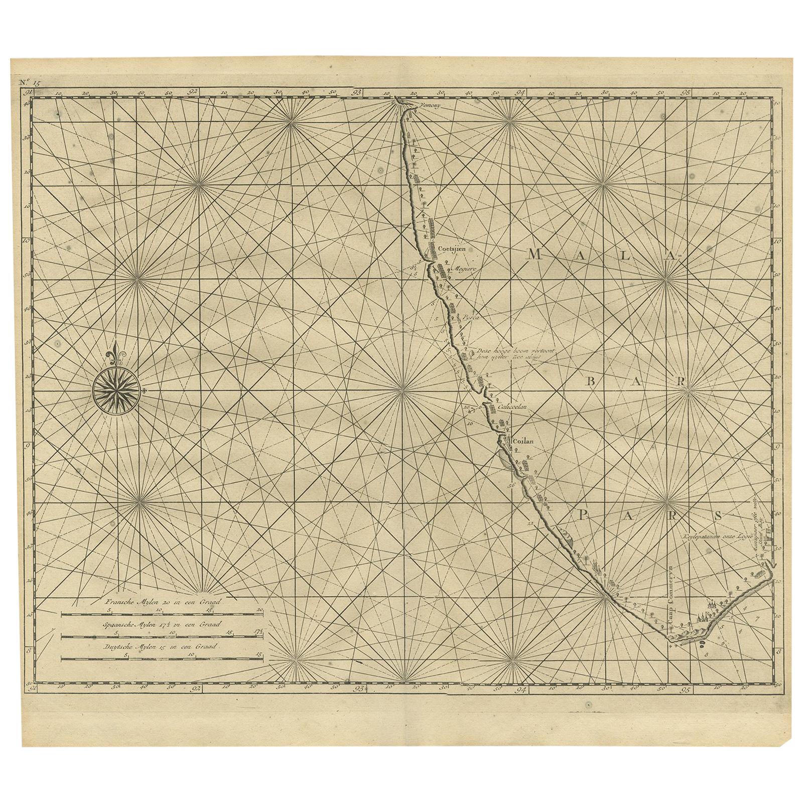
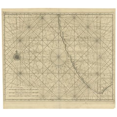
Antique Map of Malabar Coast by Valentijn, 1726
By F. Valentijn
Located in Langweer, NL
Untitled sea chart of the coast of Malabar, India. This print originates from 'Oud en Nieuw Oost-Indiën' by F. Valentijn.
Category
Antique Early 18th Century Dutch Maps
Materials
Paper
You May Also Like
Original Antique Map of The World by Thomas Clerk, 1817
Located in St Annes, Lancashire
Great map of The Eastern and Western Hemispheres
On 2 sheets
Copper-plate engraving
Drawn and engraved by Thomas Clerk, Edinburgh.
Published by Mackenzie And Dent, 1817
...
Category
Antique 1810s English Maps
Materials
Paper

Map of the Republic of Genoa
Located in New York, NY
Framed antique hand-coloured map of the Republic of Genoa including the duchies of Mantua, Modena, and Parma.
Europe, late 18th century.
Dimension: 25...
Category
Antique Late 18th Century European Maps

Antique Map of Principality of Monaco
By Antonio Vallardi Editore
Located in Alessandria, Piemonte
ST/619 - "Old Geographical Atlas of Italy - Topographic map of ex-Principality of Monaco" -
ediz Vallardi - Milano -
A somewhat special edition ---
Category
Antique Late 19th Century Italian Other Prints
Materials
Paper

Antique 18th Century Map of the Province of Pensilvania
Pennsylvania State
Located in Philadelphia, PA
A fine antique of the colony of Pennsylvania.
Noted at the top of the sheet as a 'Map of the province of Pensilvania'.
This undated and anonymous map is thought to be from the Gentleman's Magazine, London, circa 1775, although the general appearance could date it to the 1760's.
The southern boundary reflects the Mason-Dixon survey (1768), the western boundary is placed just west of Pittsburgh, and the northern boundary is not marked.
The map has a number of reference points that likely refer to companion text and appear to be connected to boundaries. The western and southern boundaries are marked Q, R, S, for example. A diagonal line runs from the Susquehanna R to the Lake Erie P. A broken line marked by many letters A, B, N, O, etc., appears in the east.
There are no latitude or longitude markings, blank verso.
Framed in a shaped contemporary gilt wooden frame and matted under a cream colored matte.
Bearing an old Graham Arader Gallery...
Category
Antique 18th Century British American Colonial Maps
Materials
Paper

Map "Estuary- Mouth of the Thames"
Located in Alessandria, Piemonte
ST/426 - Antique French Map of the estuary of the Thames, map dated 1769 -
"Mape of the entrance of the Thames. Designed by filing of Navy cards fo...
Category
Antique Mid-18th Century French Other Prints
Materials
Paper

Original Antique Map of Sweden, Engraved by Barlow, 1806
Located in St Annes, Lancashire
Great map of Sweden
Copper-plate engraving by Barlow
Published by Brightly & Kinnersly, Bungay, Suffolk. 1806
Unframed.
Category
Antique Early 1800s English Maps
Materials
Paper

More Ways To Browse
Illustrated Map
Antique World Maps
Antique Southern Furniture
Map Of Europe
Antique Maps Of Holland
Compass Rose Antique
Antique Furniture Portugal
Antique Maps Of Europe
Mexican Antiques
Map Of Africa
Mississippi Antique
Antique Furniture Plans
Ancient Collectibles
Antique Wood Coat Of Arms
Antique Quadrant
Antique Maps Of Africa
Antique Map India
Antique Map Of The South Of France