Items Similar to Antique Map of the Region of Dongeradeel by Schotanus, 1664
Want more images or videos?
Request additional images or videos from the seller
1 of 5
Antique Map of the Region of Dongeradeel by Schotanus, 1664
$176.49
£130.68
€148
CA$243.77
A$261.08
CHF 140.36
MX$3,171
NOK 1,773.47
SEK 1,623.74
DKK 1,127.95
About the Item
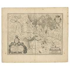
Antique map titled 'De Grietenije van Dongeradeel West-zyde der Pasens (..)'. Map of the Grietenij of Dongeradeel, Friesland, The Netherlands. Multiple cartouches, key and coat of arms. Originates from "Beschrijvinge ende nieuwe caerten van de Heerlyckheydt van Frieslandt (…).", by Schotanus a Sterringa, first published in 1664.
Artists and Engravers: Bernardus Schotanus a Sterringa (1640-1704) was a Dutch / Frisian cartographer from Franeker.
Condition: Fair, given age. Two vertical creases, left and right. Edges with an occasional tiny tear. Bottom left and right corner paper loss; restored and part of the cartouche lower left retouched. Some creasing in the left and right margins. Original middle fold as issued. General age-related toning and/or occasional minor defects from handling. Please study image carefully.
Date: 1664
Overall size: 40 x 31 cm.
Image size: 36 x 27.7 cm.
We sell original antique maps to collectors, historians, educators and interior decorators all over the world. Our collection includes a wide range of authentic antique maps from the 16th to the 20th centuries. Buying and collecting antique maps is a tradition that goes back hundreds of years. Antique maps have proved a richly rewarding investment over the past decade, thanks to a growing appreciation of their unique historical appeal. Today the decorative qualities of antique maps are widely recognized by interior designers who appreciate their beauty and design flexibility. Depending on the individual map, presentation, and context, a rare or antique map can be modern, traditional, abstract, figurative, serious or whimsical. We offer a wide range of authentic antique maps for any budget.
- Dimensions:Height: 12.21 in (31 cm)Width: 15.75 in (40 cm)Depth: 0 in (0.01 mm)
- Materials and Techniques:
- Period:
- Date of Manufacture:1664
- Condition:
- Seller Location:Langweer, NL
- Reference Number:Seller: PCT-578881stDibs: LU3054327873162
About the Seller
5.0
Recognized Seller
These prestigious sellers are industry leaders and represent the highest echelon for item quality and design.
Platinum Seller
Premium sellers with a 4.7+ rating and 24-hour response times
Established in 2009
1stDibs seller since 2017
2,826 sales on 1stDibs
Typical response time: 1 hour
- ShippingRetrieving quote...Shipping from: Langweer, Netherlands
- Return Policy
More From This Seller
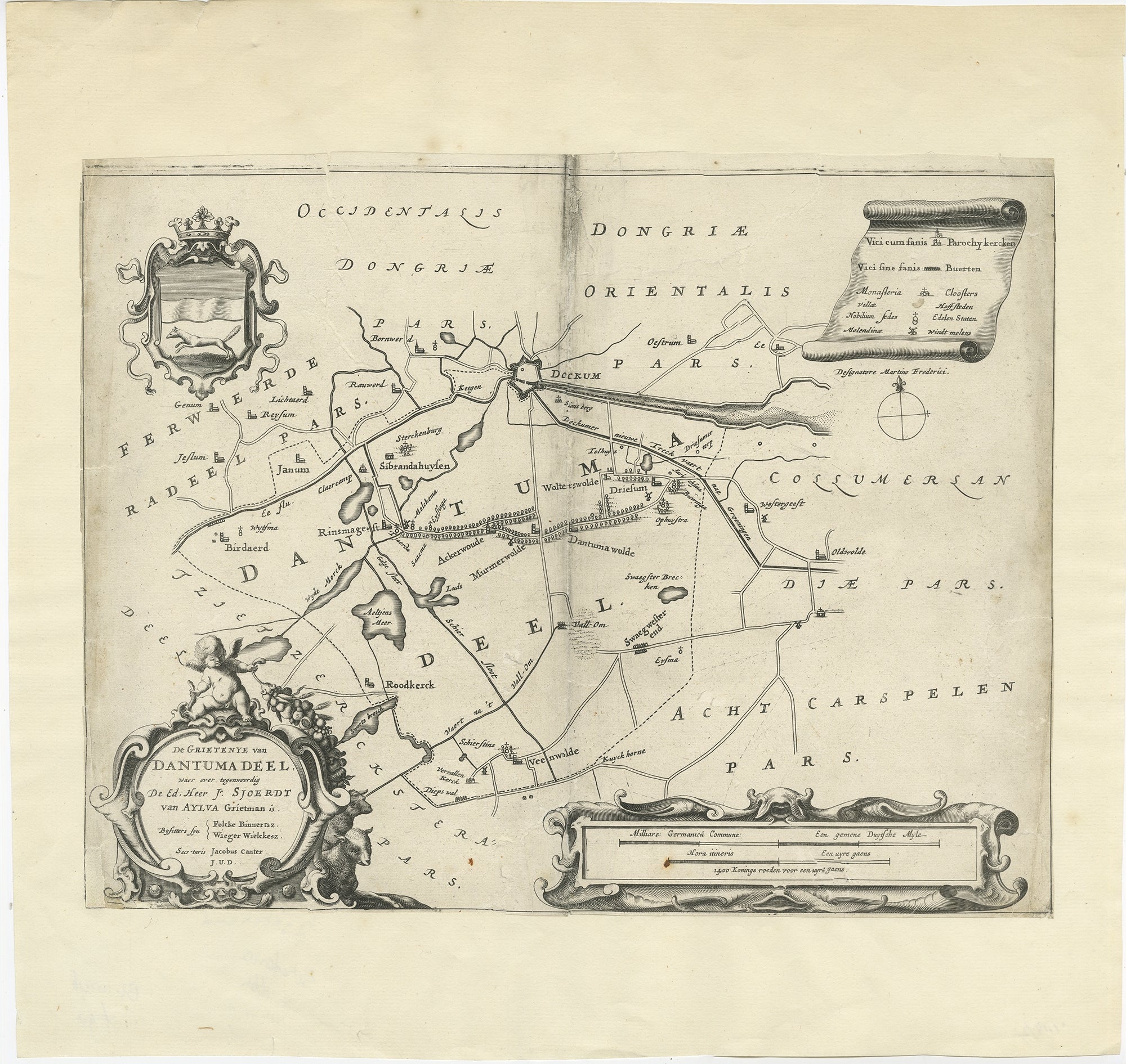
View AllAntique Map of the Region of Dantumadeel by Schotanus, 1664
Located in Langweer, NL
Antique map titled 'De Grietenye van Dantumadeel (..)'. Map of the Grietenij of Dantumadeel, Friesland, The Netherlands. Originates from "Beschrijvinge ende nieuwe caerten van de Hee...
Category
Antique 17th Century Maps
Materials
Paper
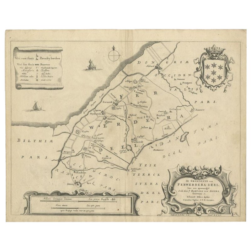
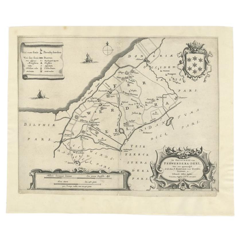
Antique Map of the Region of Ferwerderadeel by Schotanus, 1664
Located in Langweer, NL
Antique map titled 'De Grietenye van Ferwerdera-Deel (..)'. Map of the Grietenij of Ferwerderadeel, Friesland, The Netherlands. Originates from "Beschrijvinge ende nieuwe caerten van...
Category
Antique 17th Century Maps
Materials
Paper
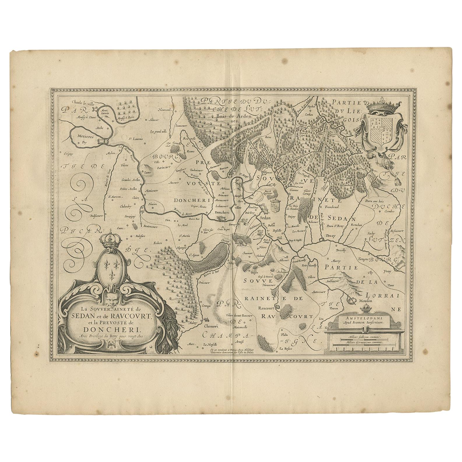
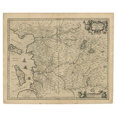
Antique Map of the Region of Sedan and Doncheri by Janssonius, 1657
By Johannes Janssonius
Located in Langweer, NL
Antique map of France titled 'La Souveraineté de Sedan et de Raucourt, et la prevosté de Doncheri'. Lovely map centered on Sedan and Doncheri and the Meuze River from Charleville and...
Category
Antique Mid-17th Century Maps
Materials
Paper
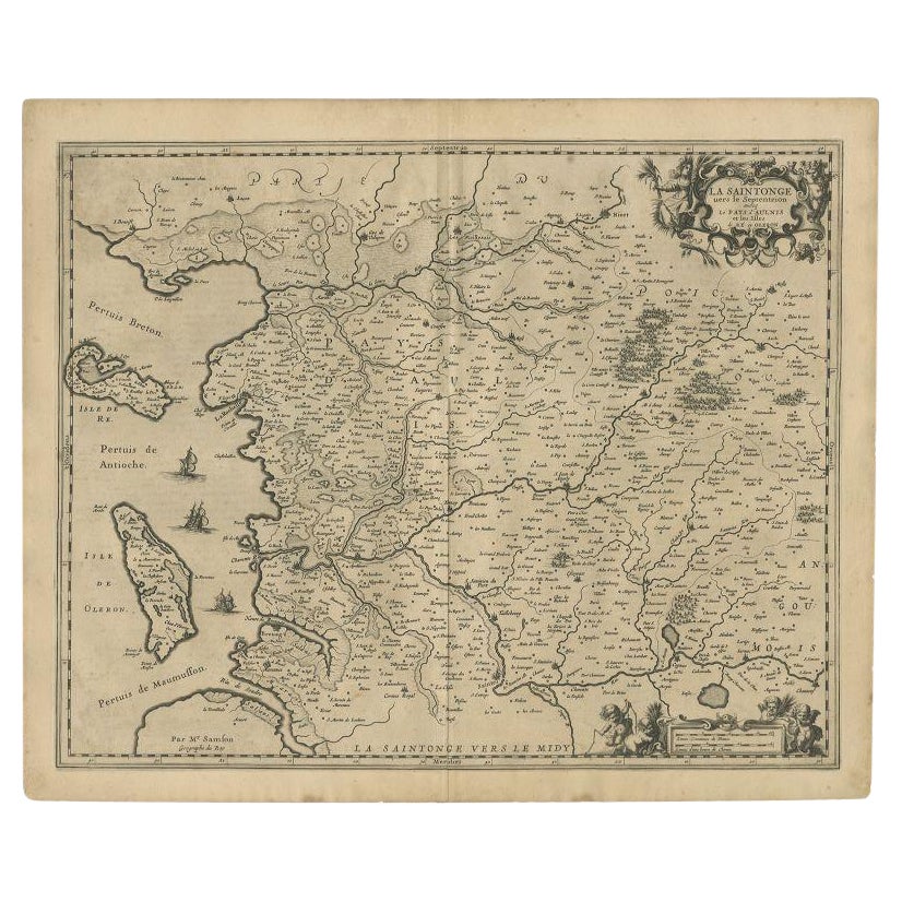
Antique Map of the Region of Saintonge by Janssonius, 1657
By Johannes Janssonius
Located in Langweer, NL
Antique map of France titled 'La Saintonge vers le Septentrion avecq le Pays d'Aulnis'. Decorative map of the Saintonge region. Includes Ile de Re, Ile d'Oleron and the cities of Nio...
Category
Antique 17th Century Maps
Materials
Paper
Antique Map of the Region of Ferwerderadeel in The Netherlands, 1664
Located in Langweer, NL
Antique map titled 'De Grietenye van Ferwerdera-Deel (..)'. Map of the Grietenij of Ferwerderadeel, Friesland, The Netherlands. Originates from "Beschrijvinge ende nieuwe caerten van...
Category
Antique 17th Century Maps
Materials
Paper
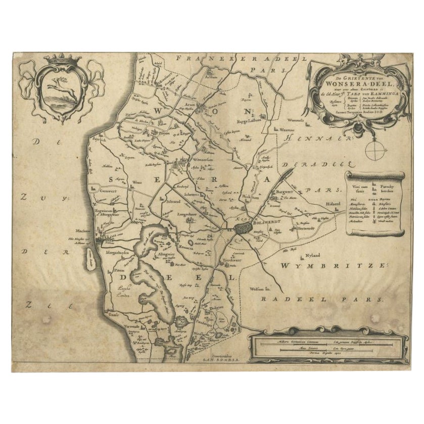
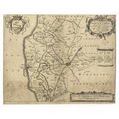
Antique Map of the Region of Wonseradeel by Schotanus, 1664
By B. Schotanus
Located in Langweer, NL
Antique map titled 'De Grietenije van Wonsera-deel (..).' Map of the Grietenij of Wonseradeel, Friesland, The Netherlands. Multiple cartouches, key and coat of arms. "Beschrijvinge e...
Category
Antique 17th Century Maps
Materials
Paper
You May Also Like
1657 Janssonius Map of Vermandois and Cappelle, Ric. A-004
Located in Norton, MA
1657 Janssonius map of
Vermandois and Cappelle
Ric.a004
Description: Antique map of France titled 'Descriptio Veromanduorum - Gouvernement de la Cappelle'. Two detailed maps o...
Category
Antique 17th Century Unknown Maps
Materials
Paper

1633 Map "La Souverainete De Sedan Et De Raucourt, Et La Prevoste Ric0011
Located in Norton, MA
1653 map entitled
"La Souverainete de Sedan et de Raucourt, et la Prevoste de Doncheri,"
Ric0011
Description:
Lovely map centered on Sedan and Doncheri and the Meuze River fr...
Category
Antique 17th Century Dutch Maps
Materials
Paper

1630 Pierre Petit map "Description du Gouvernement de la Capelle" Ric0010
Located in Norton, MA
1630 Pierre Petit map entitled
"Description du Gouvernement de la Capelle,"
Ric0010
Pierre Petit was the son of a minor provincial official in Montluçon. The town, in the Auver...
Category
Antique 17th Century Dutch Maps
Materials
Paper

1635 Willem Blaeu Map of Northern France"Comitatvs Bellovacvm" Ric.a08
Located in Norton, MA
1635 Willem Blaeu map of northern France, entitled.
"Comitatvs Bellovacvm Vernacule Beavvais,"
Colored
Ric.a008
“COMITATVS BELLOVACVM…” Amsterdam: W...
Category
Antique 17th Century Unknown Maps
Materials
Paper

1752 Vaugoundy Map of Flanders : Belgium, France, and the Netherlands, Ric.a002
Located in Norton, MA
Large Vaugoundy Map of Flanders:
Belgium, France, and the Netherlands
Colored -1752
Ric.a002
Description: This is a 1752 Didier Robert de Vaugondy map of Flanders. The map de...
Category
Antique 17th Century Unknown Maps
Materials
Paper

1643 Willem&Joan Blaeu Map NW Flanders "Flandriae Teutonicae Pars Prientalior
Located in Norton, MA
1643 Willem and Joan Blaeu map of northwest Flanders, entitled
"Flandriae Teutonicae Pars Prientalior,"
Ric0012
" Authentic" - Map of the northwest Fl...
Category
Antique 17th Century Dutch Maps
Materials
Paper

More Ways To Browse
Johann Baptist Homann On Sale
Magellan Map
Map Of Puerto Rico
Map Ukraine
Papua New Guinea Antique Map
Serbia Antique Map
Stanford Antique Furniture
Tipu Sultan
Used Office Furniture Cornwall
Vintage Wooden Roller
Albania Antique Map
Ancient Bible
Antique Bermuda Furniture
Antique Constellation Map
Antique Map Burgundy
Antique Map Of Hawaii
Antique Maps Of Long Island
Calcutta Map