Items Similar to Antique Map of the Region of Île-de-France by Hondius, circa 1630


Want more images or videos?
Request additional images or videos from the seller
1 of 5
Antique Map of the Region of Île-de-France by Hondius, circa 1630
$660.49
£489.19
€550
CA$903.52
A$983.31
CHF 521.25
MX$11,829.97
NOK 6,611.14
SEK 6,048.73
DKK 4,191.09
About the Item
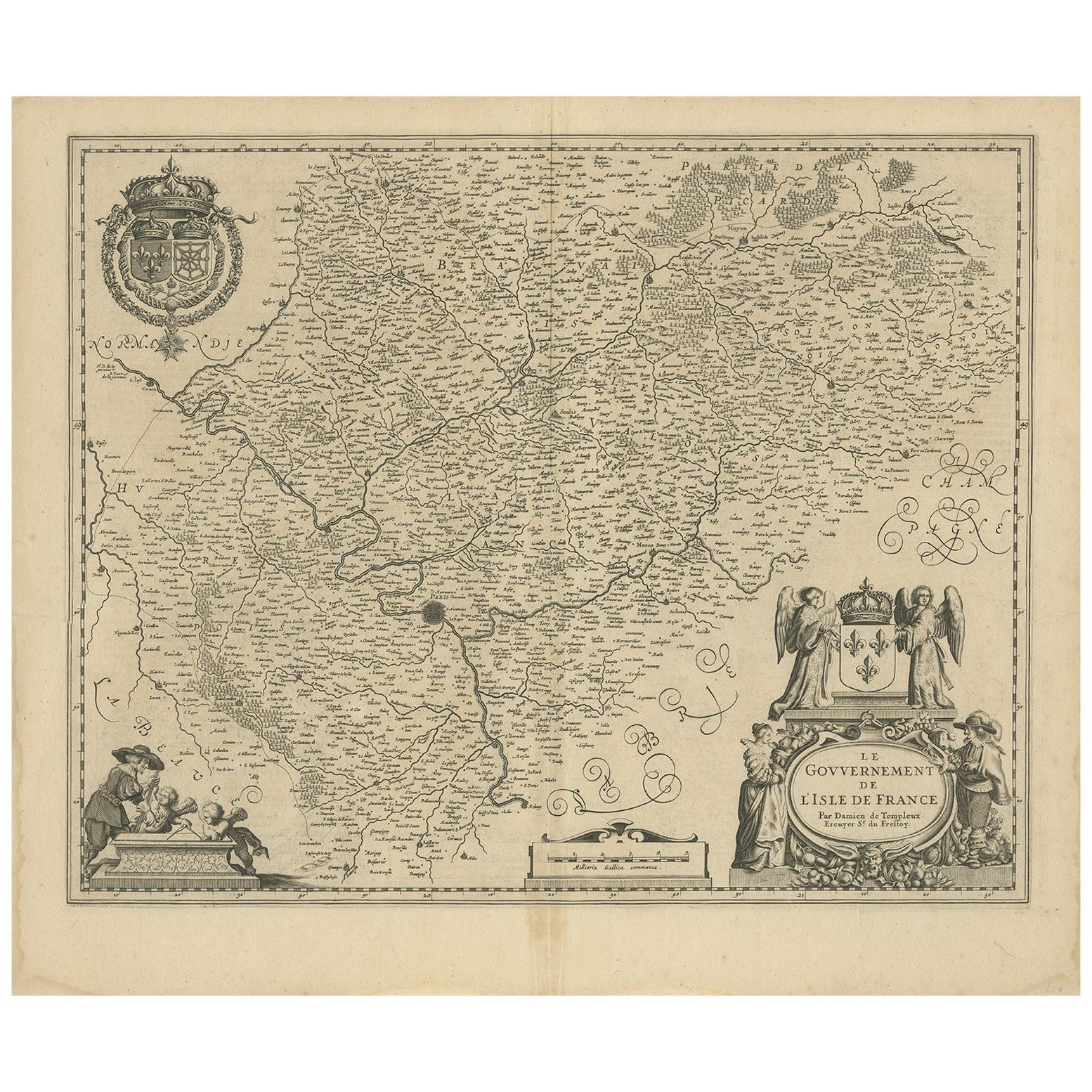
Antique map titled Gouvernement de l'Isle de France'. Old map of the region of Île-de-France, France. It is located in the north-central part of the country and often called the région parisienne ("Paris Region") because it includes the city of Paris. This map originates from a composite atlas and most likely published by Hondius.
- Dimensions:Height: 19.49 in (49.5 cm)Width: 23.04 in (58.5 cm)Depth: 0.02 in (0.5 mm)
- Materials and Techniques:
- Period:Mid-17th Century
- Date of Manufacture:circa 1630
- Condition:Original/contemporary hand coloring. Latin text on verso. Minor wear and defects, please study images carefully.
- Seller Location:Langweer, NL
- Reference Number:Seller: BG-12380-211stDibs: LU3054317848001
About the Seller
5.0
Recognized Seller
These prestigious sellers are industry leaders and represent the highest echelon for item quality and design.
Platinum Seller
Premium sellers with a 4.7+ rating and 24-hour response times
Established in 2009
1stDibs seller since 2017
2,816 sales on 1stDibs
Typical response time: 1 hour
- ShippingRetrieving quote...Shipping from: Langweer, Netherlands
- Return Policy
More From This Seller
View AllAntique Map of France by Mortier
c.1710
Located in Langweer, NL
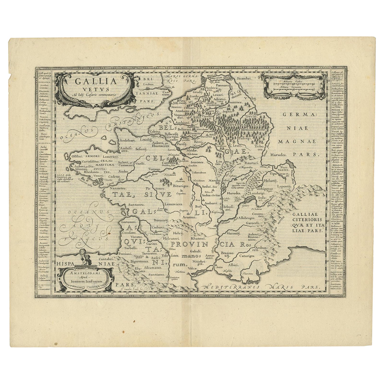
Antique map titled 'Gallia vetus ex C. Iulii Caesaris (..)'. Original antique map of France. Published by P. Mortier, c.1710.
Category
Antique Early 18th Century Maps
Materials
Paper

$960 Sale Price
20% Off
Antique Map of the Region of Beauvais by Hondius, circa 1630
Located in Langweer, NL
Antique map titled 'Beauvaisis - Comitatus Belovacium'. Old map of the region of Beauvais, France. This map originates from a composite atlas and is signed by J. Hondius.
Category
Antique Mid-17th Century Maps
Materials
Paper

Antique Map of France by Janssonius, c.1650
Located in Langweer, NL
Antique map titled 'Gallia Vetus'. Beautiful map of France based on Caesar's De Bello Gallico. In the columns to the left and right important tribes and people are described.
Art...
Category
Antique 17th Century Maps
Materials
Paper
Antique Map of the Region of Lyon by Hondius, circa 1630
Located in Langweer, NL
Antique map titled 'Lionnois, Forest et Beauiolois'. Old map of the former region of Lyon, Vienne, Bresse, Rohan and the Rhône River. This map originates f...
Category
Antique Mid-17th Century Maps
Materials
Paper

Antique Map of the Region of
Île de France
by Janssonius, circa 1650
By Johannes Janssonius
Located in Langweer, NL
Antique map of France titled 'Le Gouvernement de L'Isle de France'. Paris is represented by a miniature plan of the city, making it distinct from the other towns of the region which ...
Category
Antique Mid-17th Century Maps
Materials
Paper
Antique Map of the Region of Blois by Janssonius,
circa 1640
By Johannes Janssonius
Located in Langweer, NL
Antique map titled 'Description du Blaisois'. Old map of the region of Blois, France. It shows the city of Blois, Amboise, the Loire River and more. Published by J. Janssonius, circa...
Category
Antique Mid-17th Century Maps
Materials
Paper

$390 Sale Price
35% Off
You May Also Like
1640 Joan Bleau Map Entitled"Diocecese de rheims et le pais de rethel, " Eic.a011
Located in Norton, MA
1640 Joan Bleau map entitled
"Diocecese de rheims et le pais de rethel,"
Ric.a011
OAN BLAEU
Diocecese de Rheims, et le pais de Rethel.
Handcolored engraving, c.1640.
...
Category
Antique 17th Century Dutch Maps
Materials
Paper

The Normandy Region of France: A 17th C. Hand-colored Map by Sanson and Jaillot
By Nicolas Sanson
Located in Alamo, CA
This large hand-colored map entitled "Le Duché et Gouvernement de Normandie divisée en Haute et Basse Normandie en divers Pays; et par evêchez, avec le Gouvernement General du Havre ...
Category
Antique 1690s French Maps
Materials
Paper

$1,900 Sale Price
20% Off
1656 Jansson Map Metz Region of France Entitled "Territorium Metense" Ric0014
Located in Norton, MA
1656 Jansson map Metz Region of France entitled "Territorium Metense."
Ric0014
" Authentic" - Map of the historical region surrounding Metz, in Lorraine, France.
Oriented with ...
Category
Antique 17th Century Dutch Maps
Materials
Paper

1635 Willem Blaeu Map of Northern France"Comitatvs Bellovacvm" Ric.a08
Located in Norton, MA
1635 Willem Blaeu map of northern France, entitled.
"Comitatvs Bellovacvm Vernacule Beavvais,"
Colored
Ric.a008
“COMITATVS BELLOVACVM…” Amsterdam: W...
Category
Antique 17th Century Unknown Maps
Materials
Paper

1630 Pierre Petit map "Description du Gouvernement de la Capelle" Ric0010
Located in Norton, MA
1630 Pierre Petit map entitled
"Description du Gouvernement de la Capelle,"
Ric0010
Pierre Petit was the son of a minor provincial official in Montluçon. The town, in the Auver...
Category
Antique 17th Century Dutch Maps
Materials
Paper

1633 Map "La Souverainete De Sedan Et De Raucourt, Et La Prevoste Ric0011
Located in Norton, MA
1653 map entitled
"La Souverainete de Sedan et de Raucourt, et la Prevoste de Doncheri,"
Ric0011
Description:
Lovely map centered on Sedan and Doncheri and the Meuze River fr...
Category
Antique 17th Century Dutch Maps
Materials
Paper

More Ways To Browse
Antique Map Paris
Map Of Paris
Blaeu Maps
Antique Topographic Maps
Antique Maps Of North America
Antique Maps Of Italy
Antique Navigator
Antique Maps Of Britain
Wood Furniture Bali
Scotland Map
Antique Maps Scotland
Furniture Russian 18th Century
Antique Map Of Middle East
London Antique Maps
Map Colorful
Maps Of Australia
Antique Railroad Furniture
Map Of London