Items Similar to Antique Map of the Region of Leeuwarden and Dokkum in The Netherlands, 1791


Want more images or videos?
Request additional images or videos from the seller
1 of 6
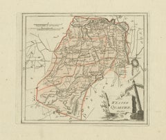
Antique Map of the Region of Leeuwarden and Dokkum in The Netherlands, 1791
$151.44
$189.9020% Off
£112.18
£140.6720% Off
€126
€15820% Off
CA$207.16
CA$259.7820% Off
A$225.80
A$283.1420% Off
CHF 119.38
CHF 149.7020% Off
MX$2,718.18
MX$3,408.5120% Off
NOK 1,515.20
NOK 1,900.0120% Off
SEK 1,389.13
SEK 1,741.9220% Off
DKK 960.05
DKK 1,203.8720% Off
About the Item
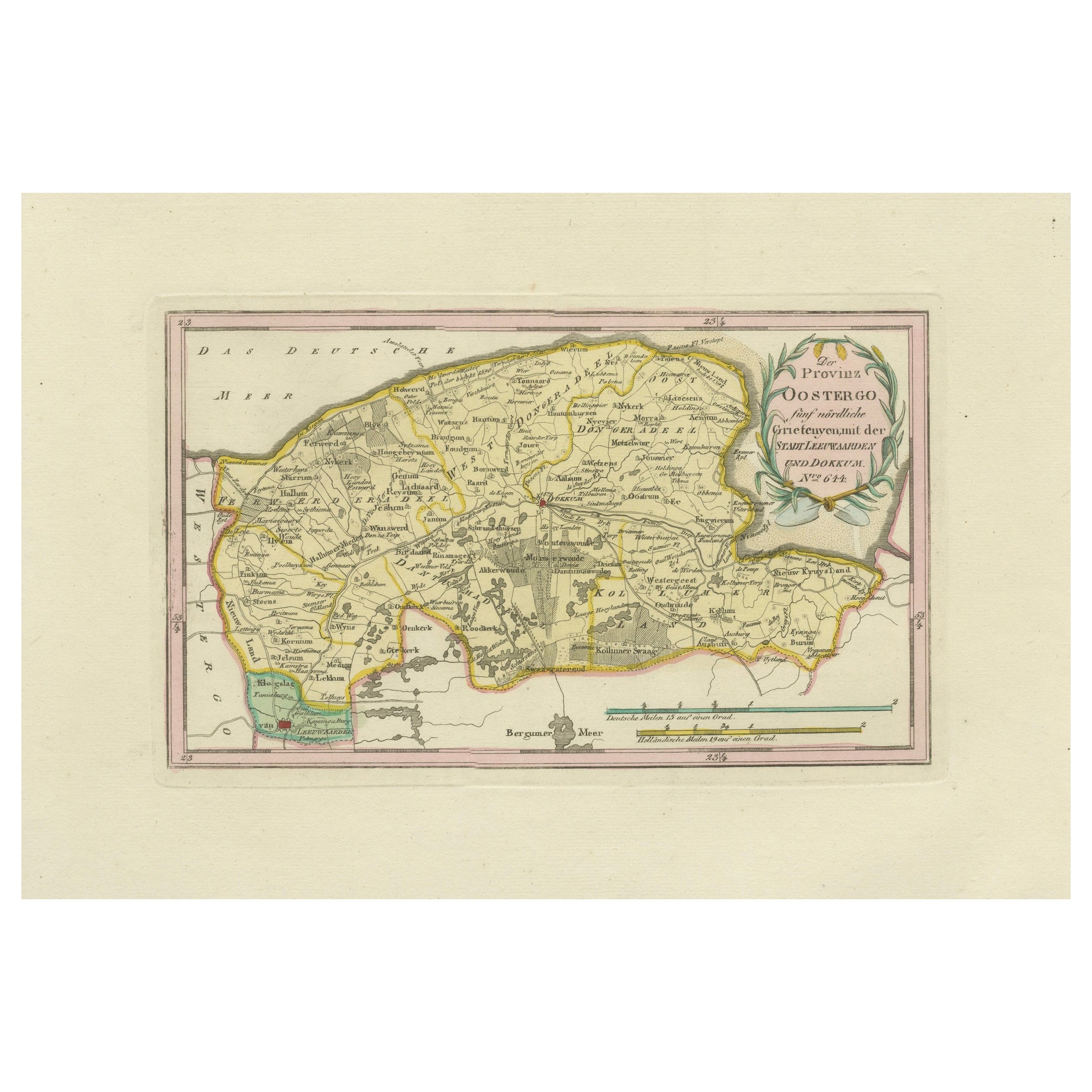
Antique map titled 'Der Provinz Oostergo fünf nördliche Grietenyen mit der Stadt Leeuwaarden und Dokkum'. Map of the region of Leeuwarden and Dokkum, Friesland, the Netherlands. This map orginates from 'Schauplatz der fünf Theile der Welt'.
Artists and Engravers: Franz Joseph Johann von Reilly (1766-1820) was a Vienna based art dealer. He is also known as the author of two atlases. The maps were engraved by Ignaz Alberti (also Ignaz Albrecht, 1760-1794). Ignaz was an Austrian illustrator, publisher and engraver.
Condition: Good, general age-related toning. Original/contemporary hand coloring. Blank verso. Please study image carefully.
Date: 1791
Overall size: 39.5 x 29 cm.
Image size: 29 x 17 cm.
We sell original antique maps to collectors, historians, educators and interior decorators all over the world. Our collection includes a wide range of authentic antique maps from the 16th to the 20th centuries. Buying and collecting antique maps is a tradition that goes back hundreds of years. Antique maps have proved a richly rewarding investment over the past decade, thanks to a growing appreciation of their unique historical appeal. Today the decorative qualities of antique maps are widely recognized by interior designers who appreciate their beauty and design flexibility. Depending on the individual map, presentation, and context, a rare or antique map can be modern, traditional, abstract, figurative, serious or whimsical. We offer a wide range of authentic antique maps for any budget.
- Dimensions:Height: 11.42 in (29 cm)Width: 15.56 in (39.5 cm)Depth: 0 in (0.01 mm)
- Materials and Techniques:
- Period:
- Date of Manufacture:1791
- Condition:Condition: Good, general age-related toning. Original/contemporary hand coloring. Blank verso. Please study image carefully.
- Seller Location:Langweer, NL
- Reference Number:Seller: PCT-7341stDibs: LU3054327830252
About the Seller
5.0
Recognized Seller
These prestigious sellers are industry leaders and represent the highest echelon for item quality and design.
Platinum Seller
Premium sellers with a 4.7+ rating and 24-hour response times
Established in 2009
1stDibs seller since 2017
2,813 sales on 1stDibs
Typical response time: 1 hour
- ShippingRetrieving quote...Shipping from: Langweer, Netherlands
- Return Policy
More From This Seller
View AllAntique Map of Leeuwarden and Dokkum, Friesland by von Reilly, 1791
Located in Langweer, NL
Antique Map of Leeuwarden and Dokkum, Friesland by von Reilly, 1791
Original engraved map titled Der Provinz Oostergo fünf nördliche Grietenyen, mit der Stadt Leeuwarden und Dokkum ...
Category
Antique 18th Century Austrian Maps
Materials
Paper
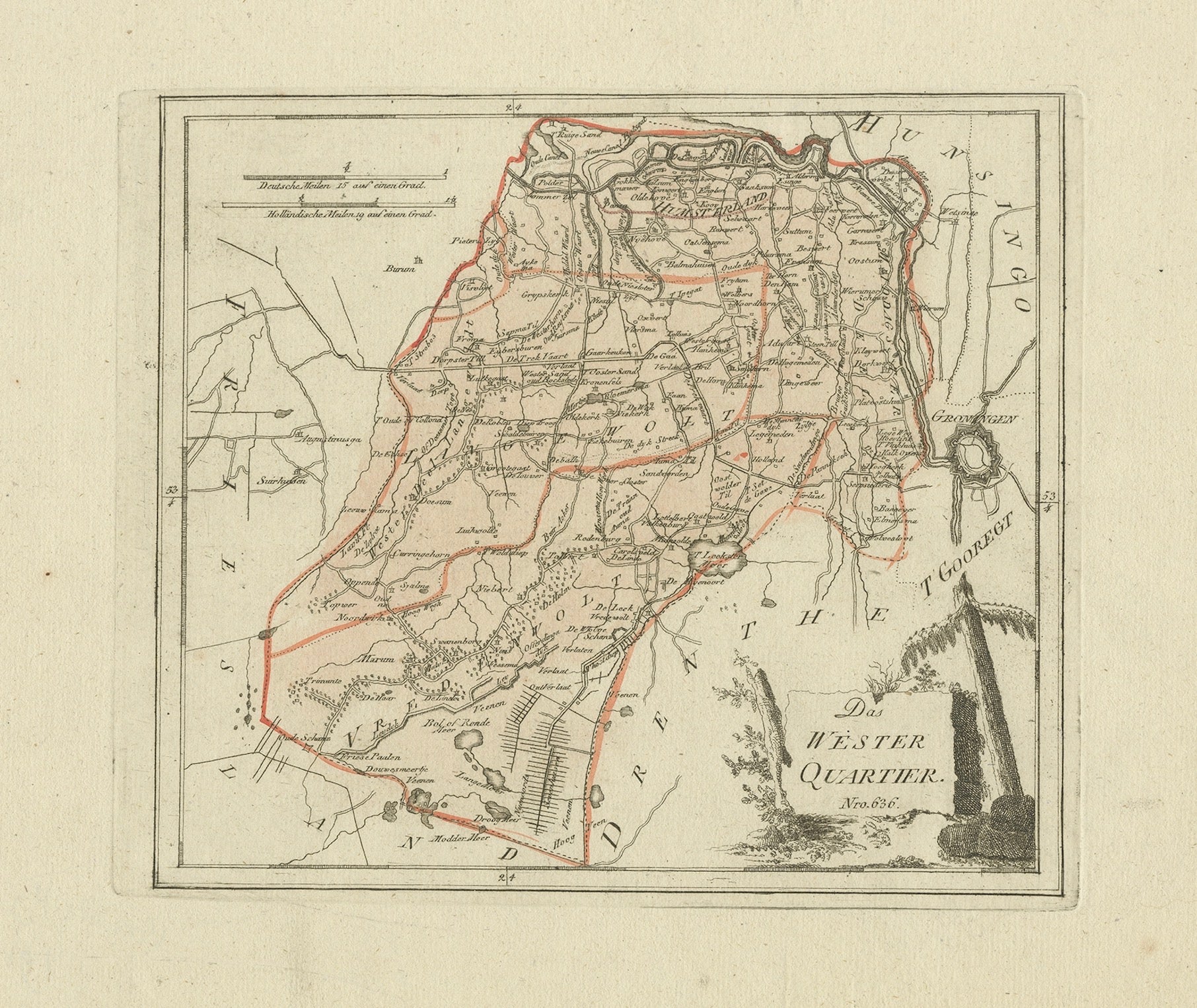
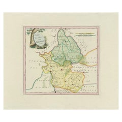
Antique map Westerkwartier Groningen by von Reilly, Vienna, 1791
Located in Langweer, NL
Title: Antique map Westerkwartier Groningen by von Reilly, Vienna, 1791
Engraved map with original hand color of the Westerkwartier (western quarter) of the province of Groningen, N...
Category
Antique 18th Century Austrian Maps
Materials
Paper
Rare 1791 von Reilly Map of Franeker and Harlingen, Friesland, Netherlands
Located in Langweer, NL
Antique Map of Franeker and Harlingen by von Reilly, 1791
Fine original map titled Der Provinz Westergo vier nördliche Grietenyen mit der Stadt Franeker und Harlingen, published in ...
Category
Antique 18th Century Austrian Maps
Materials
Paper

Antique Map of Overijssel by Van Jagen, 1771
Located in Langweer, NL
Antique map titled 'L'Over-Issel'. This map depicts the Dutch province Overijssel. This map originates from 'Nouvel Atlas, très exact et fort commode pour toutes sortes de personnes,...
Category
Antique 18th Century Maps
Materials
Paper

$182 Sale Price
20% Off
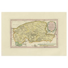
Antique Map of the Region of Gaasterland, Friesland, The Netherlands, 1791
Located in Langweer, NL
Antique map of Gaasterland with towns of Friesland by von Reilly, 1791
Antique engraved map with original hand color of the southern Friesland region known as Gaasterland, titled “D...
Category
Antique 18th Century Austrian Maps
Materials
Paper

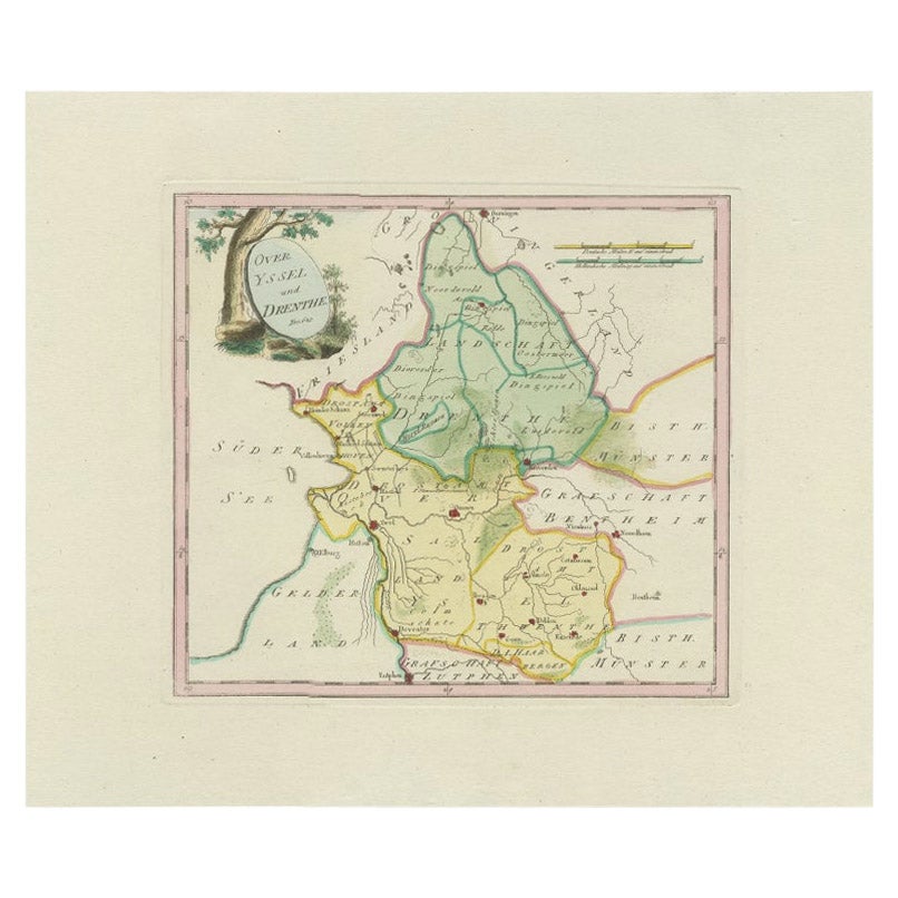
Antique Map of Overijssel and Drenthe by Von Reilly, c.1795
Located in Langweer, NL
Antique map titled 'Overyssel und Drenthe'. Decorative map of Overijssel and Drenthe, The Netherlands. This map originates from 'Schauplatz Der Funf Theile der Welt' (Wien: Reilly, 1...
Category
Antique 18th Century Maps
Materials
Paper
$149 Sale Price
20% Off
You May Also Like
1752 Vaugoundy Map of Flanders : Belgium, France, and the Netherlands, Ric.a002
Located in Norton, MA
Large Vaugoundy Map of Flanders:
Belgium, France, and the Netherlands
Colored -1752
Ric.a002
Description: This is a 1752 Didier Robert de Vaugondy map of Flanders. The map de...
Category
Antique 17th Century Unknown Maps
Materials
Paper

1635 Willem Blaeu Map of Northern France"Comitatvs Bellovacvm" Ric.a08
Located in Norton, MA
1635 Willem Blaeu map of northern France, entitled.
"Comitatvs Bellovacvm Vernacule Beavvais,"
Colored
Ric.a008
“COMITATVS BELLOVACVM…” Amsterdam: W...
Category
Antique 17th Century Unknown Maps
Materials
Paper

1643 Willem&Joan Blaeu Map NW Flanders "Flandriae Teutonicae Pars Prientalior
Located in Norton, MA
1643 Willem and Joan Blaeu map of northwest Flanders, entitled
"Flandriae Teutonicae Pars Prientalior,"
Ric0012
" Authentic" - Map of the northwest Fl...
Category
Antique 17th Century Dutch Maps
Materials
Paper

1640 Willem Blaeu Map Entitled "Contado di molise et principato vltra, " Ric.a003
By Willem Blaeu
Located in Norton, MA
1640 Willem Blaeu map entitled
"Contado di molise et principato vltra,"
Colored
Ric. a003
Measures: 38 x 49.6 cm and wide margins
DBLAEU.
Cou...
Category
Antique 17th Century Dutch Maps
Materials
Paper

1771 Bonne Map of Poitou, Touraine and Anjou, France, Ric.a015
Located in Norton, MA
1771 Bonne Map of Poitou,
Touraine and Anjou, France
Ric.a015
1771 Bonne map of Potiou, Touraine and Anjou entitled "Carte des Gouvernements D'Anjou et du Saumurois, de la Touraine, du Poitou,du Pays d'aunis, Saintonge?Angoumois,"
Carte des gouvernements d'Anjou et du Saumurois, de la Touraine, du Poitou, du Pays d'Aunis, Saintonge-Angoumois. Projettee et assujettie au ciel par M. Bonne, Hyd. du Roi. A Paris, Chez Lattre, rue St. Jacques a la Ville de Bord(ea)ux. Avec priv. du Roi. 1771. Arrivet inv. & sculp., Atlas moderne ou collection de cartes sur toutes...
Category
Antique 17th Century Unknown Maps
Materials
Paper

1620 Map of Artois Entitled "Artesia Comitatvs Artois, " by Bleau, Ric.a012
Located in Norton, MA
1640 map of Artois entitled
"Artesia Comitatvs Artois,"
by Bleau
Colored
A-012.
Detailed map of the northern province of Artois, France on the border with Belgium. Feature...
Category
Antique 17th Century Dutch Maps
Materials
Paper

More Ways To Browse
Franz Joseph
Antique Maps Of Kansas
Garde Corps
Marie Galante
Nevada Antique Map
Nova Scotia Antique Furniture
Patagonia Map
Antique Furniture South Carolina
Antique Map Of Boston
Antique Map Of Venice
Antique Maps Of Maryland
Charlotte Reine
Cleveland Antique Furniture
Gambia Antique Map
Johann Baptist Homann On Sale
Magellan Map
Map Of Puerto Rico
Map Ukraine