Items Similar to Antique Map of the Region of Paterwolde and Assen by Craandijk, 1884
Want more images or videos?
Request additional images or videos from the seller
1 of 5
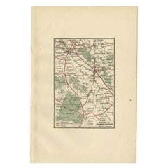
Antique Map of the Region of Paterwolde and Assen by Craandijk, 1884
$104.21
£77.93
€87
CA$143.58
A$156.59
CHF 82.95
MX$1,877.31
NOK 1,056.44
SEK 966.03
DKK 662.97
About the Item
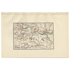
"Antique map titled 'Omstreken van Paterwolde - Omstreken van Assen '. Two maps on one image. The upper map depicts the region of Paterwolde also including cities and villages like Eelde and Noordlaren. The lower map depicts the region of Assen lso including cities and villages like Rolde and Anrijp. This map orginates from 'Atlas behoorende bij Wandelingen door Nederland met Pen en Potlood'.
Artists and Engravers: Author: J. Craandijk. Published by H.D. Tjeenk Willink, Haarlem.
Condition: Good, general age-related toning. Minor defects from handling, please study image carefully.
Date: 1884
Overall size: 18 x 26.7 cm.
Image size: 10.4 x 15.9 cm.
We sell original antique maps to collectors, historians, educators and interior decorators all over the world. Our collection includes a wide range of authentic antique maps from the 16th to the 20th centuries. Buying and collecting antique maps is a tradition that goes back hundreds of years. Antique maps have proved a richly rewarding investment over the past decade, thanks to a growing appreciation of their unique historical appeal. Today the decorative qualities of antique maps are widely recognized by interior designers who appreciate their beauty and design flexibility. Depending on the individual map, presentation, and context, a rare or antique map can be modern, traditional, abstract, figurative, serious or whimsical. We offer a wide range of authentic antique maps for any budget.
- Dimensions:Height: 10.52 in (26.7 cm)Width: 7.09 in (18 cm)Depth: 0 in (0.01 mm)
- Materials and Techniques:
- Period:
- Date of Manufacture:1884
- Condition:
- Seller Location:Langweer, NL
- Reference Number:Seller: BG-00954-11stDibs: LU3054327914092
About the Seller
5.0
Recognized Seller
These prestigious sellers are industry leaders and represent the highest echelon for item quality and design.
Platinum Seller
Premium sellers with a 4.7+ rating and 24-hour response times
Established in 2009
1stDibs seller since 2017
2,791 sales on 1stDibs
Typical response time: <1 hour
- ShippingRetrieving quote...Shipping from: Langweer, Netherlands
- Return Policy
More From This Seller
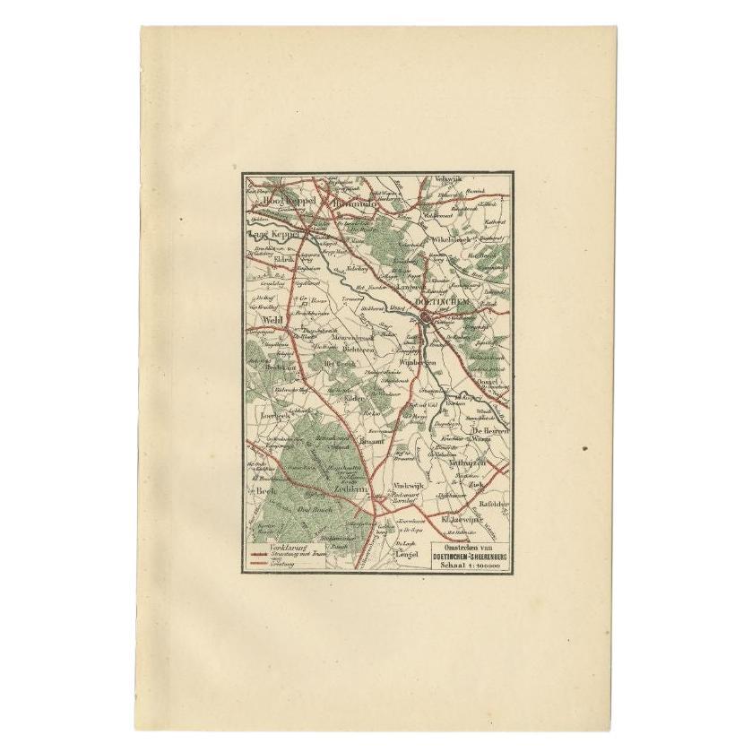
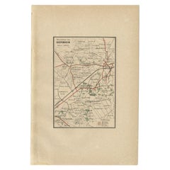
View AllAntique Map of the Region of Doetinchem by Craandijk, 1884
Located in Langweer, NL
Antique map titled 'Omstreken van Doetinchem - 's Heerenberg'. Old map of the region of Doetinchem also including cities and villages like Keppel, Wehl and Zeddam. This map orginates...
Category
Antique 19th Century Maps
Materials
Paper
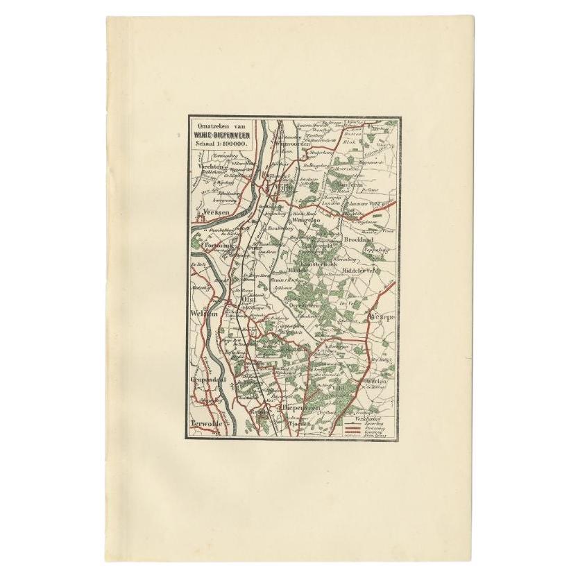
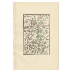
Antique Map of the Region of Wijhe-Diepenveen by Craandijk, 1884
Located in Langweer, NL
Antique map titled 'Omstreken van Wijhe - Diepenveen'. Old map of the region of Wijhe also including cities and villages like Olst, Welsum and Veessen. This map orginates from 'Atlas...
Category
Antique 19th Century Maps
Materials
Paper
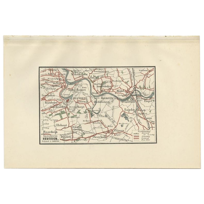
Antique Map of the Region of Heusden by Craandijk, 1884
Located in Langweer, NL
Antique map titled 'Omstreken van Heusden'. Old map of the region of Heusden also including cities and villages like Elshout, Aalburg, Hedel and Vlijmen. This map orginates from 'Atl...
Category
Antique 19th Century Maps
Materials
Paper
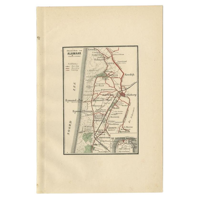
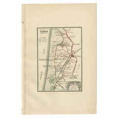
Antique Map of the Region of Alkmaar by Craandijk, 1884
Located in Langweer, NL
Antique map titled 'Omstreken van Alkmaar'. Old map of the region of Alkmaar also including cities and villages like Castricum, Egmond, Oudorp and Den Helder. This map orginates from...
Category
Antique 19th Century Maps
Materials
Paper
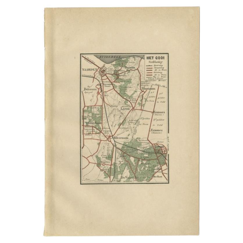
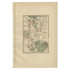
Antique Map of the Gooi Region by Craandijk, 1884
Located in Langweer, NL
Antique map titled 'Het Gooi'. Old map of the region of Hilversum also including cities and villages like Naarden, Laren, Blaricum, Eemnes and Baarn. This map orginates from 'Atlas b...
Category
Antique 19th Century Maps
Materials
Paper
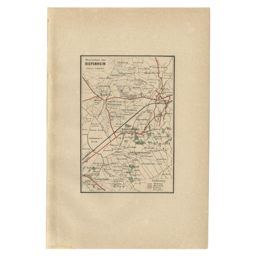
Antique Map of the Region of Diepenheim by Craandijk, 1884
Located in Langweer, NL
Antique map titled 'Omstreken van Diepenheim'. Old map of the region of Diepenheim also including cities and villages like Markelo, Goor and Gelselaar. This map orginates from 'Atlas...
Category
Antique 19th Century Maps
Materials
Paper
You May Also Like
Original Antique English County Map, Huntingdonshire, J
C Walker, 1851
Located in St Annes, Lancashire
Great map of Huntingdonshire
Original colour
By J & C Walker
Published by Longman, Rees, Orme, Brown & Co. 1851
Unframed.
Category
Antique 1850s English Other Maps
Materials
Paper

Original Antique English County Map, Cambridgeshire, J
C Walker, 1851
Located in St Annes, Lancashire
Great map of Cambridgeshire
Original colour
By J & C Walker
Published by Longman, Rees, Orme, Brown & Co. 1851
Unframed.
Category
Antique 1850s English Other Maps
Materials
Paper

Original Antique English County Map, Buckinghamshire, J
C Walker, 1851
Located in St Annes, Lancashire
Great map of Buckinghamshire
Original colour
By J & C Walker
Published by Longman, Rees, Orme, Brown & Co. 1851
Unframed.
Category
Antique 1850s English Other Maps
Materials
Paper

Original Antique English County Map, Nottinghamshire, J
C Walker, 1851
Located in St Annes, Lancashire
Great map of Nottinghamshire
Original colour
By J & C Walker
Published by Longman, Rees, Orme, Brown & Co. 1851
Unframed.
Category
Antique 1850s English Other Maps
Materials
Paper

Original Antique English County Map, Leicestershire, J
C Walker, 1851
Located in St Annes, Lancashire
Great map of Leicestershire
Original colour
By J & C Walker
Published by Longman, Rees, Orme, Brown & Co. 1851
Unframed.
Category
Antique 1850s English Other Maps
Materials
Paper

Original Antique English County Map, Warwickshire, J
C Walker, 1851
Located in St Annes, Lancashire
Great map of Warwickshire
Original colour
By J & C Walker
Published by Longman, Rees, Orme, Brown & Co. 1851
Unframed.
Category
Antique 1850s English Other Maps
Materials
Paper

More Ways To Browse
Map Of Puerto Rico
Map Ukraine
Papua New Guinea Antique Map
Serbia Antique Map
Stanford Antique Furniture
Tipu Sultan
Used Office Furniture Cornwall
Vintage Wooden Roller
Albania Antique Map
Ancient Bible
Antique Bermuda Furniture
Antique Constellation Map
Antique Map Burgundy
Antique Map Of Hawaii
Antique Maps Of Long Island
Calcutta Map
Gibraltar Antique Map
Guyana Antique Map