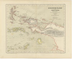
Items Similar to Antique Map of Riouw, Lingga Archipelago, Singapore, Banda by Dornseiffen - 1884


Want more images or videos?
Request additional images or videos from the seller
1 of 13
Antique Map of Riouw, Lingga Archipelago, Singapore, Banda by Dornseiffen - 1884
$407.26
£304.54
€340
CA$561.11
A$611.97
CHF 324.18
MX$7,336.63
NOK 4,128.60
SEK 3,775.30
DKK 2,590.94
About the Item
Antique Map of Riouw, Lingga Archipelago, Singapore, Dornseiffen - 1884
This finely detailed antique map depicts the Riouw–Lingga Archipelago (Riau–Lingga), including Batam, Bintan, Lingga, Singkep, and the surrounding island groups lying between Singapore, Sumatra, and the South China Sea. Issued as part of the official late-19th-century Dutch colonial survey series, this important cartographic work was designed by J. Dornseiffen and published in Amsterdam by Seyffardt’s Boekhandel in 1884. The sheet also includes a large secondary map of Ambon, the Oeliasers, and the Banda Islands, making this a highly desirable dual-region composition.
The Riouw–Lingga section shows an exceptionally dense maze of islands, straits, anchorages, rivers, and settlements, engraved with scientific precision. Batam and Bintan appear prominently near Singapore, underscoring the long-standing geopolitical importance of this maritime corridor. Original hand coloring distinguishes administrative divisions with clarity and elegance. The companion Ambon–Banda map charts one of the most historically significant spice-producing zones on earth, including Banda Neira and its surrounding islands, isolated in the Banda Sea.
Historically, both regions were of immense strategic and economic value to Dutch colonial power. The Riouw–Lingga Archipelago controlled vital shipping routes between the Indian Ocean and the South China Sea, while Ambon and Banda formed the very core of the global nutmeg and clove monopoly that built the Dutch East India Company’s fortunes. By 1884, when Dornseiffen produced this map, these zones were fully integrated into a centralized colonial state, and the map reflects that mature phase of imperial governance through fixed borders and detailed inland surveying.
Visually, this sheet is exceptionally elegant and complex. The contrast between the densely clustered Riouw archipelagos and the open Banda Sea surrounding Ambon creates a dynamic and well-balanced composition. Subtle pastel coloring, crisp engraving, and refined typography give the map great decorative authority while preserving its scientific character. It works beautifully as a standalone statement piece or as part of a larger Dornseiffen wall ensemble.
This map is increasingly sought after by collectors of Indonesian history, Singapore-related cartography, Dutch East Indies maritime heritage, and VOC-era spice trade material. The inclusion of both the Riouw–Lingga gateway and the Ambon–Banda spice core on one sheet makes this an especially desirable crossover piece for high-level collections.
Condition report: Good antique condition. Light general age toning consistent with 19th-century paper. Scattered foxing visible, mainly in the open sea areas and margins. Clear plate impressions present. Full margins preserved. No major tears or losses observed.
Framing tips: This map displays beautifully with a wide off-white or warm ivory mat and a dark walnut, ebonized, or antique gilt frame. Museum glass is recommended for UV protection and optimal presentation of the fine engraving and hand coloring. Ideal for libraries, studies, or refined contemporary interiors.
Technique: Hand-colored lithograph
Maker: J. Dornseiffen, Amsterdam, 1884 (published by Seyffardt’s Boekhandel)
- Dimensions:Height: 15.36 in (39 cm)Width: 19.1 in (48.5 cm)Depth: 0.01 in (0.2 mm)
- Materials and Techniques:
- Place of Origin:
- Period:
- Date of Manufacture:1884
- Condition:Condition report: Good antique condition. Light general age toning consistent with 19th-century paper. Scattered foxing visible, mainly in the open sea areas and margins. Clear plate impressions present. Full margins preserved.
- Seller Location:Langweer, NL
- Reference Number:Seller: BG-14172-141stDibs: LU3054347872972
About the Seller
5.0
Recognized Seller
These prestigious sellers are industry leaders and represent the highest echelon for item quality and design.
Platinum Seller
Premium sellers with a 4.7+ rating and 24-hour response times
Established in 2009
1stDibs seller since 2017
2,791 sales on 1stDibs
Typical response time: <1 hour
- ShippingRetrieving quote...Shipping from: Langweer, Netherlands
- Return Policy
More From This Seller
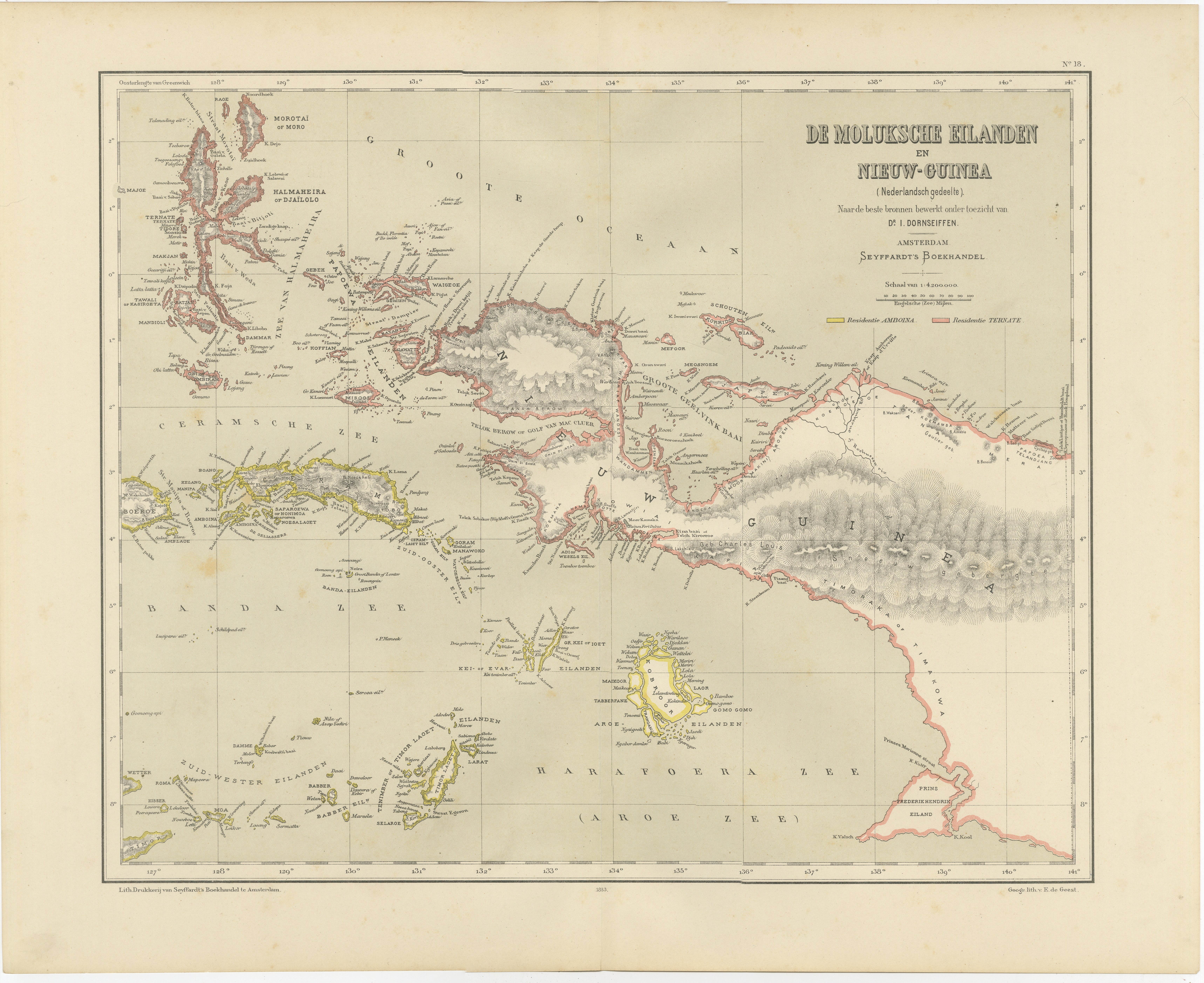
View AllAntique Colonial Dutch Map of the Moluccas
New Guinea by Dornseiffen, 1884
Located in Langweer, NL
Antique Dutch Map of the Moluccas & New Guinea by Dornseiffen 1884 Indonesia
This decorative antique map depicts the Moluccan Islands (Spice Islands) and the western portion of New ...
Category
Antique 1880s Dutch Maps
Materials
Paper
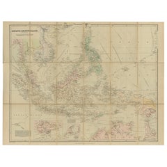
Antique Map of the Asiatic Archipelago by E. Stanford, circa 1910
Located in Langweer, NL
Antique folding map titled 'London Atlas Map of the Asiatic Archipelago'. Centered on the Philippines and Borneo, the map shows a number of different seasonal passages through the region to Hong Kong and Macao. With inset maps of Singapore...
Category
20th Century English Maps
Materials
Paper
$778 Sale Price
35% Off
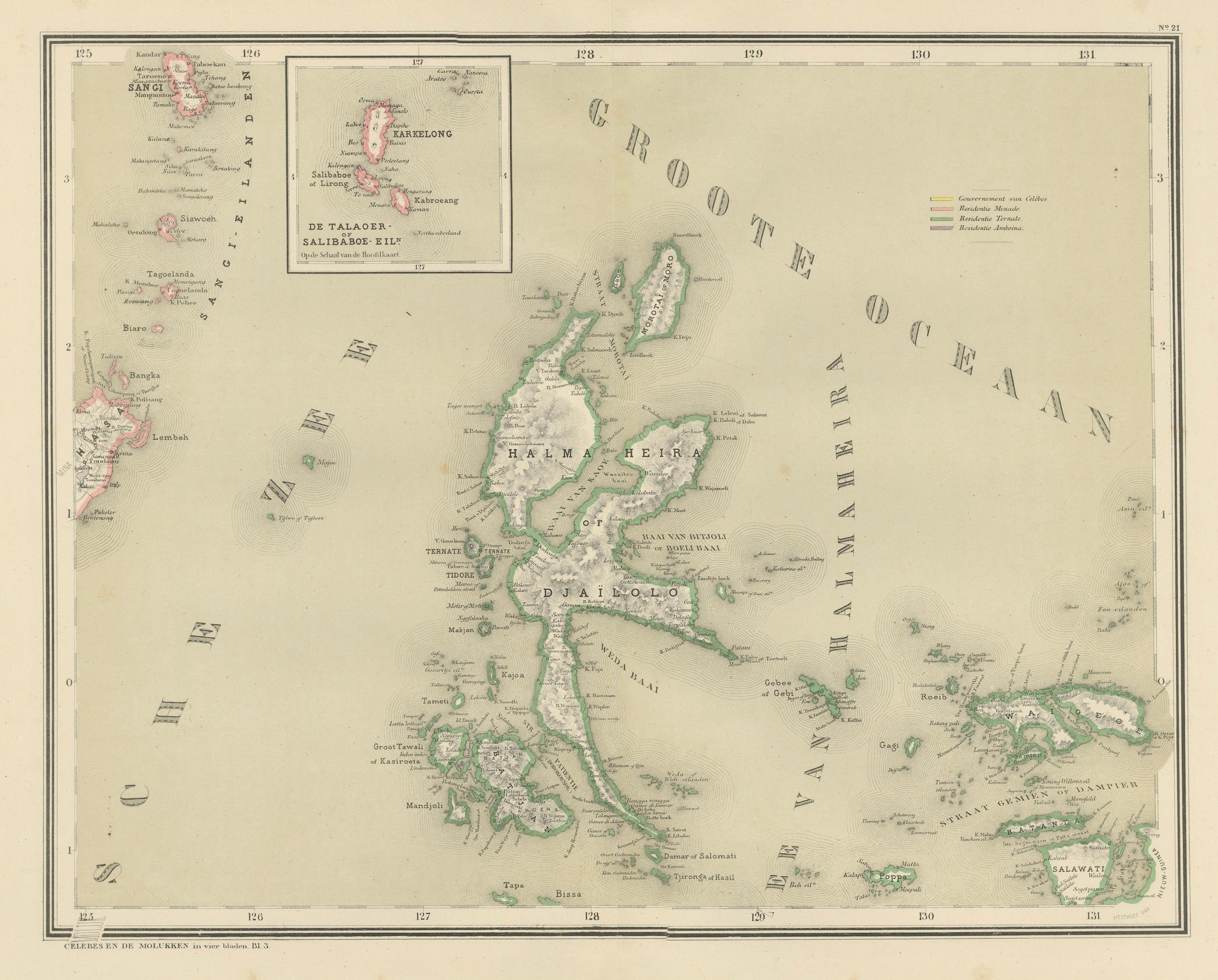
Antique Map of Halmahera, Ternate, Tidore, Moluccas by Dornseiffen - 1884
Located in Langweer, NL
Antique Map of Halmahera Ternate Tidore Moluccas Dornseiffen 1884
This finely detailed antique map depicts the northern Moluccan Islands with Halmahera (Gilolo) at its center, inclu...
Category
Antique 1880s Dutch Maps
Materials
Paper
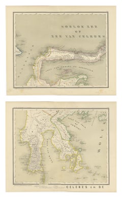
Antique Two-Sheet Map of Celebes Sulawesi - Dornseiffen, Dutch East Indies, 1884
Located in Langweer, NL
Antique Two-Sheet Map of Celebes Sulawesi by Dornseiffen, Published in 1884 - Dutch East Indies
This striking two-sheet antique map set depicts the island of Celebes (modern Sulawes...
Category
Antique 1880s Dutch Maps
Materials
Paper
Antique Map of the Nias Archipelago, Sumatra, Indonsia, 1900
Located in Langweer, NL
Antique map of Nias Island and surrounding islands including the Banyak islands, Pini island and Simeulue Island. This map originates from 'Atlas van Nederlandsch Oost- en West-Indië...
Category
20th Century Maps
Materials
Paper

Original Antique Map of the Dutch East Indies, Nowadays Indonesia, ca.1840
Located in Langweer, NL
Original antique map of the East Indies including Borneo, Celebes, Java, Sumatra and surrounding islands. Published circa 1840.
Artists and Engravers: Engraved by J. & C. Walker....
Category
Antique 1840s Maps
Materials
Paper
You May Also Like
Large Original Antique Map of The Greek Islands. 1894
Located in St Annes, Lancashire
Superb Antique map of The Greek Islands
Published Edward Stanford, Charing Cross, London 1894
Original colour
Good condition
Unframed.
Free shipping
Category
Antique 1890s English Maps
Materials
Paper

Large Original Antique Map of The Leeward Islands. 1894
Located in St Annes, Lancashire
Superb Antique map of The Leeward Islands
Published Edward Stanford, Charing Cross, London 1894
Original colour
Good condition
Unframed.
Free shipping
Category
Antique 1890s English Maps
Materials
Paper

Large Original Antique Map of Java and Borneo, Fullarton, C.1870
Located in St Annes, Lancashire
Great map of Java and Borneo
Wonderful figurative borders
From the celebrated Royal Illustrated Atlas
Lithograph. Original color.
Published by Fullarton, Edinburgh. C.1870
Unfr...
Category
Antique 1870s Scottish Maps
Materials
Paper

Ancient Map of Oceania - Original Etching - 19th century
Located in Roma, IT
This Map of Oceania is an etching realized in the 19th century.
The state of preservation of the artwork is good. At the top of the paper, the inscription “Longitudine del Meridiano...
Category
19th Century More Prints
Materials
Etching

South America, North-West Part. Century Atlas antique vintage map
Located in Melbourne, Victoria
'The Century Atlas. South America, North-West Part'
Original antique map, 1903.
Central fold as issued. Map name and number printed on the reverse corners.
Sheet 40cm by 29.5cm.
Category
Early 20th Century Victorian More Prints
Materials
Lithograph

Africa. North-West Part. Century Atlas antique vintage map
Located in Melbourne, Victoria
'The Century Atlas. Africa. Southern Part'
Original antique map, 1903.
Central fold as issued. Map name and number printed on the reverse corners.
Sheet 40cm by 29.5cm.
Category
Early 20th Century Victorian More Prints
Materials
Lithograph
