Items Similar to Antique Map of Russia in Asia by Tallis,
1851
Want more images or videos?
Request additional images or videos from the seller
1 of 5
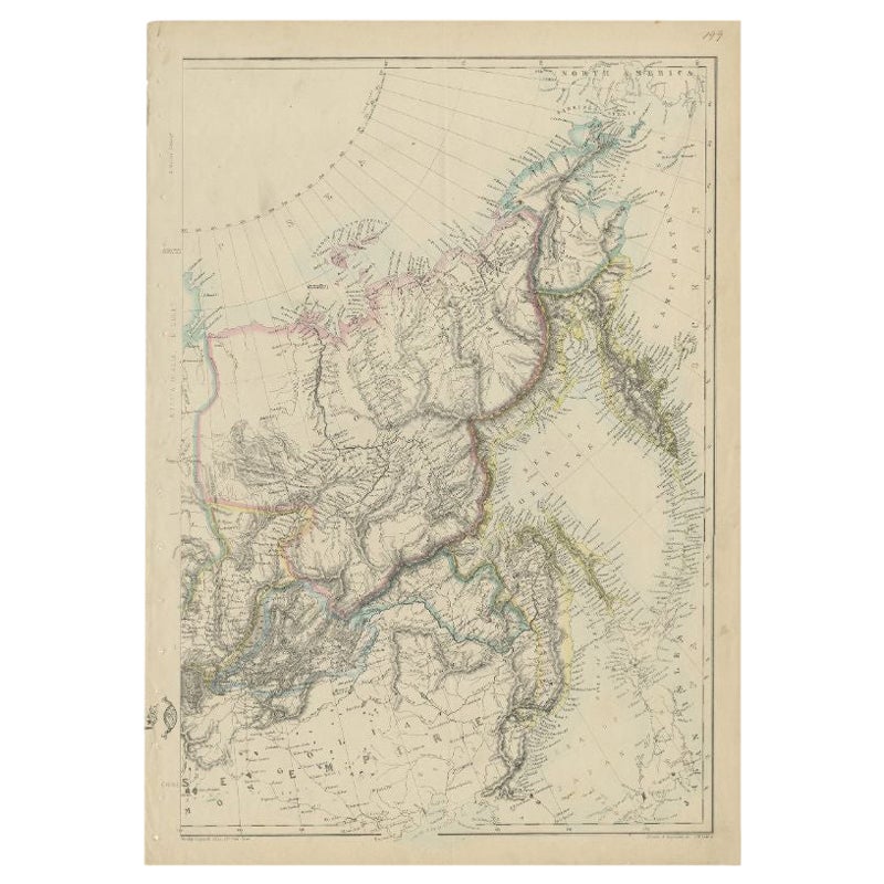
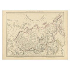
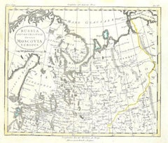
Antique Map of Russia in Asia by Tallis,
1851
$326.30
£243.60
€275
CA$453.33
A$487.63
CHF 260.60
MX$5,747.71
NOK 3,285.57
SEK 3,003.63
DKK 2,095.81
About the Item
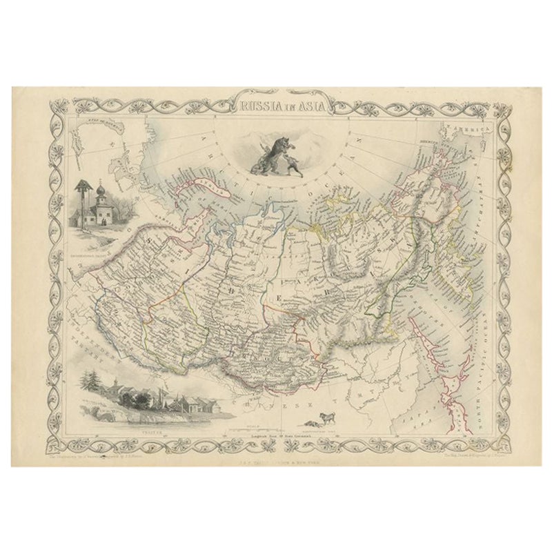
Antique map titled 'Russia in Asia'. Map of Russia in Asia. Showing vignettes of a polar hunting scene, Skorskarskoi Pagost, Troitsk and Kamchatkan Dogs. Originates from 'The Illustrated Atlas, And Modern History Of The World Geographical, Political, Commercial
Statistical, Edited By R. Montgomery Martin'.
Published; John Tallis London, New York, Edinburgh
Dublin, 1851. Drawn and Engraved by J. Rapkin.
- Dimensions:Height: 10.63 in (27 cm)Width: 14.77 in (37.5 cm)Depth: 0.02 in (0.5 mm)
- Materials and Techniques:
- Period:
- Date of Manufacture:1851
- Condition:General age-related toning. Minor wear, blank verso. Please study image carefully.
- Seller Location:Langweer, NL
- Reference Number:Seller: BG-049941stDibs: LU3054319766262
About the Seller
5.0
Recognized Seller
These prestigious sellers are industry leaders and represent the highest echelon for item quality and design.
Platinum Seller
Premium sellers with a 4.7+ rating and 24-hour response times
Established in 2009
1stDibs seller since 2017
2,836 sales on 1stDibs
Typical response time: 1 hour
- ShippingRetrieving quote...Shipping from: Langweer, Netherlands
- Return Policy
More From This Seller
View AllAntique Map of Russia in Asia by Tallis, c.1851
Located in Langweer, NL
Antique map titled 'Russia in Asia'. Map of Russia in Asia. Showing vignettes of a polar hunting scene, Skorskarskoi Pagost, Troitsk and Kamchatkan Dogs. Originates from 'The Illustrated Atlas, And Modern History Of The World Geographical, Political, Commercial & Statistical, Edited By R. Montgomery Martin'. Published; John Tallis London, New York, Edinburgh & Dublin. 1851. Drawn and Engraved by J. Rapkin. Artists and Engravers: John Tallis (1817-1876) was a British map...
Category
Antique 19th Century Maps
Materials
Paper
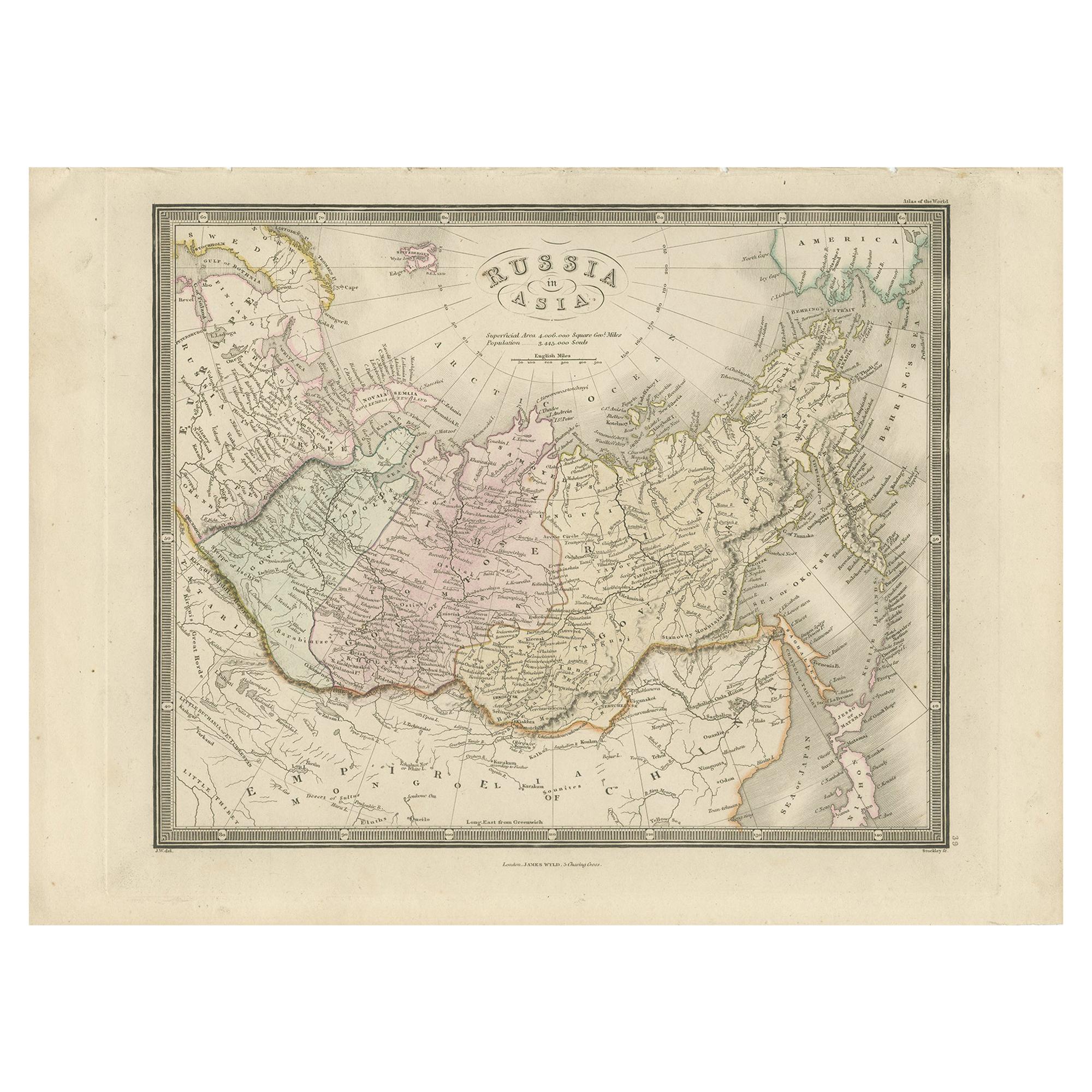
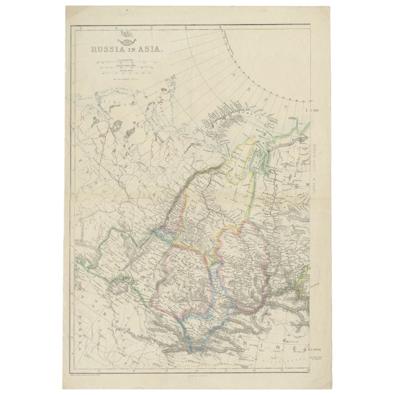
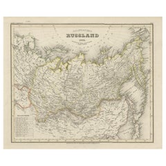
Antique Map of Russia in Asia by Wyld,
1845
Located in Langweer, NL
Antique map titled 'Russia in Asia'. Original antique map of Russia in Asia. This map originates from 'An Atlas of the World, Comprehending Separate Maps of its Various Countries, co...
Category
Antique Mid-19th Century Maps
Materials
Paper
$154 Sale Price
35% Off
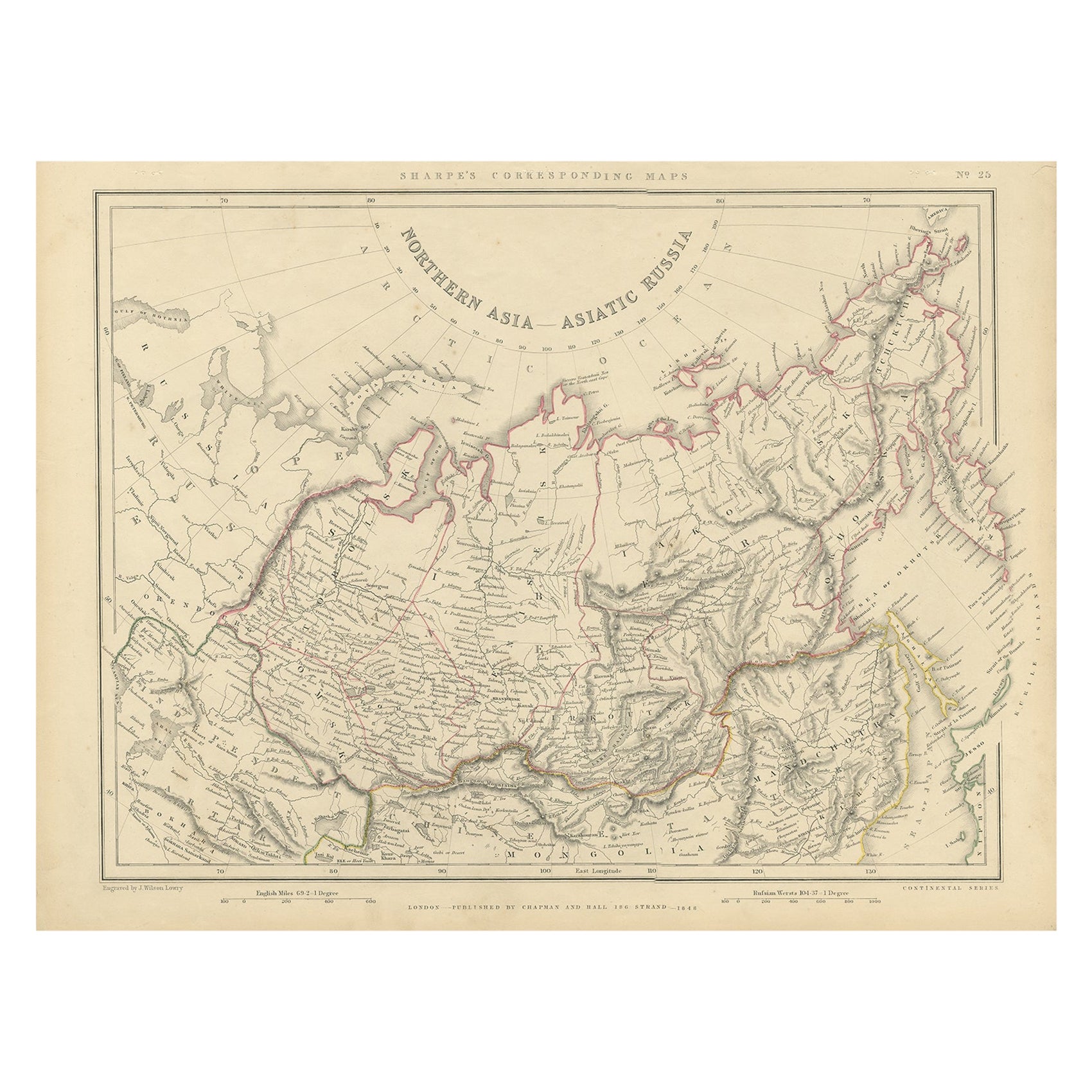
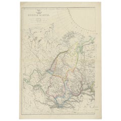
Northern Asia, Asiatic Russia, Old Map of Russia in Asia, 1849
Located in Langweer, NL
Antique map titled 'Northern Asia - Asiatic Russia'.
Old map of Russia in Asia. This map originates from 'Sharpe's Corresponding Atlas (..)' by J. Sharpe.
Artists and Engravers: Published by Chapman and Hall.
Category
Antique 1840s Maps
Materials
Paper
$170 Sale Price / item
20% Off
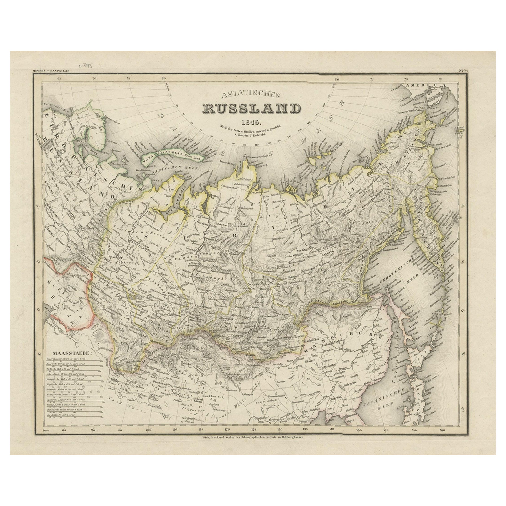
Antique Map of Russia in Asia from An Old German Atlas, 1845
By Meyer
Located in Langweer, NL
Antique map titled 'Asiatisches Russland'. This map depicts Russia in Asia and originates from 'Meyers Handatlas'.
Artists and Engravers: Engraved and published by 'Bibliographis...
Category
Antique 19th Century Maps
Materials
Paper
Antique Map of Russia in Asia by Lowry, c.1865
Located in Langweer, NL
Antique map titled 'Russia in Asia, E Sheet'. Old map of Russia originating from the 'Weekly Dispatch Atlas'. Artists and Engravers: Engraved by J.W. Lowry.
Artist: Engraved by J....
Category
Antique 19th Century Maps
Materials
Paper
$84 Sale Price
20% Off
Antique Map of Russia in Asia by Weller, c.1865
Located in Langweer, NL
Antique map titled 'Russia in Asia'. Old map of Russia originating from the 'Weekly Dispatch Atlas'. Artists and Engravers: Engraved by E. Weller.
Artist: Engraved by E. Weller.
...
Category
Antique 19th Century Maps
Materials
Paper
You May Also Like
1860 Large Map "Carte De La Siberie Russie D
asie, " Ric.R0001
Located in Norton, MA
Large 1860 map "Carte De La Siberie Russie D'Asie," R-0001
" Authentic" - 1860 map "Carte De La Siberie Russie D'Asie,"
Dimension: Paper: 68 cm W x 51 cm H ; Sight: 51cm W x 4...
Category
Antique 19th Century Unknown Maps
Materials
Paper

Large1852 Map "Russian Empire" Ric.r0011
Located in Norton, MA
Large
1852 map "Russian Empire"
George Phillips & Son 1852
Ric.r0011
Dimension: Paper: 67 cm W x 52 cm H ; Sight: 60cm W x 50 cm H
Condition: Good Condition with aged tonin...
Category
Antique 19th Century Unknown Maps
Materials
Paper

1849 Map of "Europaische Russland",
Meyer Map of European Russia
, Ric. R017
Located in Norton, MA
1849 Map of
"Europaische Russland"
( Meyer Map of European Russia)
Ric.r017
A lovely map of European Russia dating to 1849 by Joseph Meyer. It covers the European portions of...
Category
Antique 19th Century Unknown Maps
Materials
Paper

1790 Thomas Stackhouse Map, Entitled "Russia in Europe, " , Ric.a004
Located in Norton, MA
1790 Thomas Stackhouse map, entitled
"Russia in Europe"
Ric.a004
Stackhouse, Thomas
Russia in Europe [map]
London: T. Stackhouse, 1783. Map. Matted hand-colored copper engraving. Image size: 14.5 x 15.25 inches. Mat size: 22.75 x 23.75 inches. A beautiful example of this map of Eastern Europe...
Category
Antique 17th Century Unknown Maps
Materials
Paper

Map of the Russian Empire: An Original 18th Century Hand-colored Map by E. Bowen
Located in Alamo, CA
This is an original 18th century hand-colored map entitled "A New & Accurate Map of The Whole Russian Empire, As Contain'd Both In Europe and Asia, Drawn from Authentic Journals, Sur...
Category
Mid-18th Century Old Masters Landscape Prints
Materials
Engraving

Map of Russia - Original Etching - Late 19th Century
Located in Roma, IT
This Map of Russia is an etching realized by an anonymous artist.
The state of preservation of the artwork is good with some small diffused stains.
Sheet dimension:27.5 x 44
At t...
Category
Late 19th Century Modern Figurative Prints
Materials
Etching
More Ways To Browse
Antique Maps Of Italy
Antique Navigator
Antique Maps Of Britain
Scotland Map
Antique Maps Scotland
Furniture Russian 18th Century
Antique Map Of Middle East
London Antique Maps
Map Colorful
Maps Of Australia
Antique Railroad Furniture
Map Of London
Antique Galleon
Antique Maps Australia
Used Nautical Charts
Antique Collectables Australia
Joan Blaeu
Map Greece