Items Similar to Antique Map of the Santa Cruz Islands with Inset of Carteret and Gower Islands


Want more images or videos?
Request additional images or videos from the seller
1 of 6
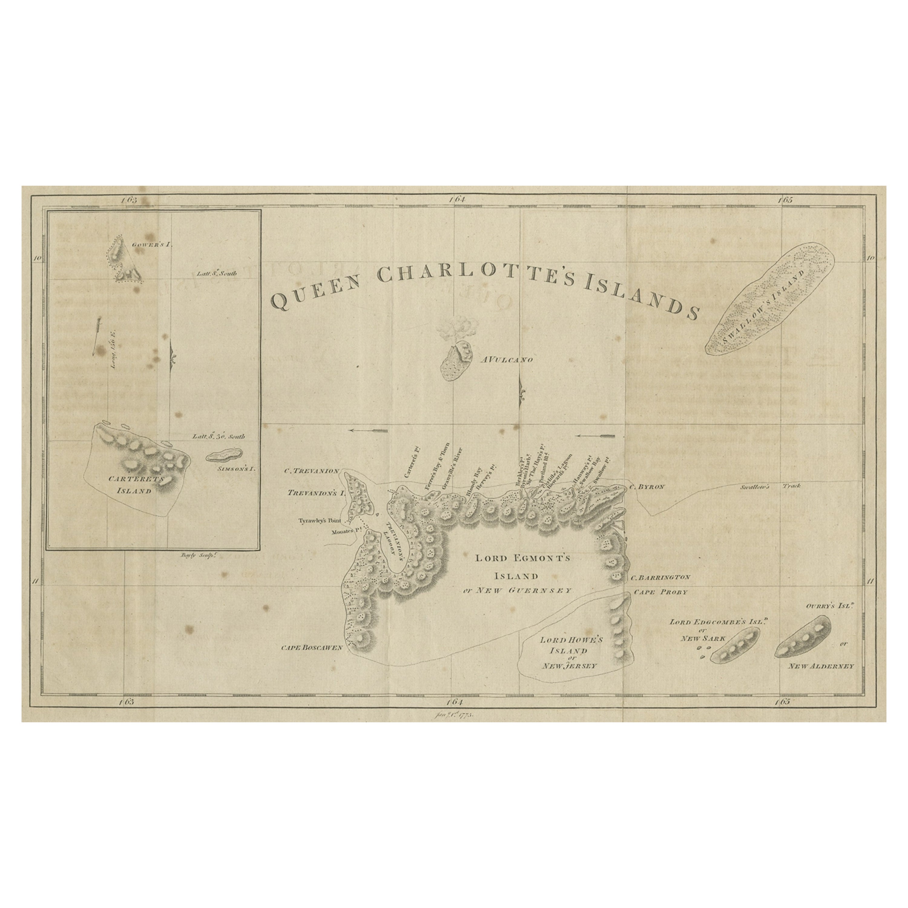
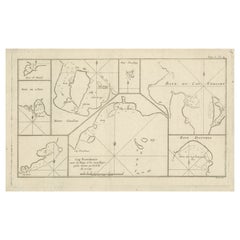
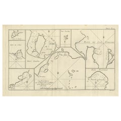
Antique Map of the Santa Cruz Islands with Inset of Carteret and Gower Islands
$287.99
$359.9920% Off
£213.42
£266.7720% Off
€240
€30020% Off
CA$393.60
CA$49220% Off
A$428.46
A$535.5820% Off
CHF 227.43
CHF 284.2920% Off
MX$5,155.33
MX$6,444.1720% Off
NOK 2,881.83
NOK 3,602.2820% Off
SEK 2,640.57
SEK 3,300.7120% Off
DKK 1,828.15
DKK 2,285.1920% Off
About the Item
Antique map titled 'Isles de la Reine Charlotte (..)'. A detailed chart of the Santa Cruz islands, to the north of the New Hebrides, with Carteret's track in "Swallow"; including an inset chart of Carteret and Gower Islands. Relief is shown by hachuring; vegetation is marked by small tree-symbols, revealing that the tops of the mountains were wooded. Along the explored coast of the "Isle Du Lord Egmont", palm trees and huts have been drawn, perhaps marking native settlements. A particularly detailed volcano spewing smoke is shown in profile to the North of this island. Prevailing winds are marked with arrows.
Published in an edition of John Hawkesworth's atlas to accompany a French edition of Captain James Cook's voyages to the Southern Hemisphere. Published 1774.
- Dimensions:Height: 10.04 in (25.5 cm)Width: 15.95 in (40.5 cm)Depth: 0.02 in (0.5 mm)
- Materials and Techniques:
- Period:
- Date of Manufacture:1774
- Condition:Repaired: Large closed tears affecting image. General age-related toning. Large closed tears affecting image. Shows some wear and soiling, blank verso. Please study image carefully.
- Seller Location:Langweer, NL
- Reference Number:Seller: BG-12707-971stDibs: LU3054334237702
About the Seller
5.0
Recognized Seller
These prestigious sellers are industry leaders and represent the highest echelon for item quality and design.
Platinum Seller
Premium sellers with a 4.7+ rating and 24-hour response times
Established in 2009
1stDibs seller since 2017
2,816 sales on 1stDibs
Typical response time: 1 hour
- ShippingRetrieving quote...Shipping from: Langweer, Netherlands
- Return Policy
More From This Seller
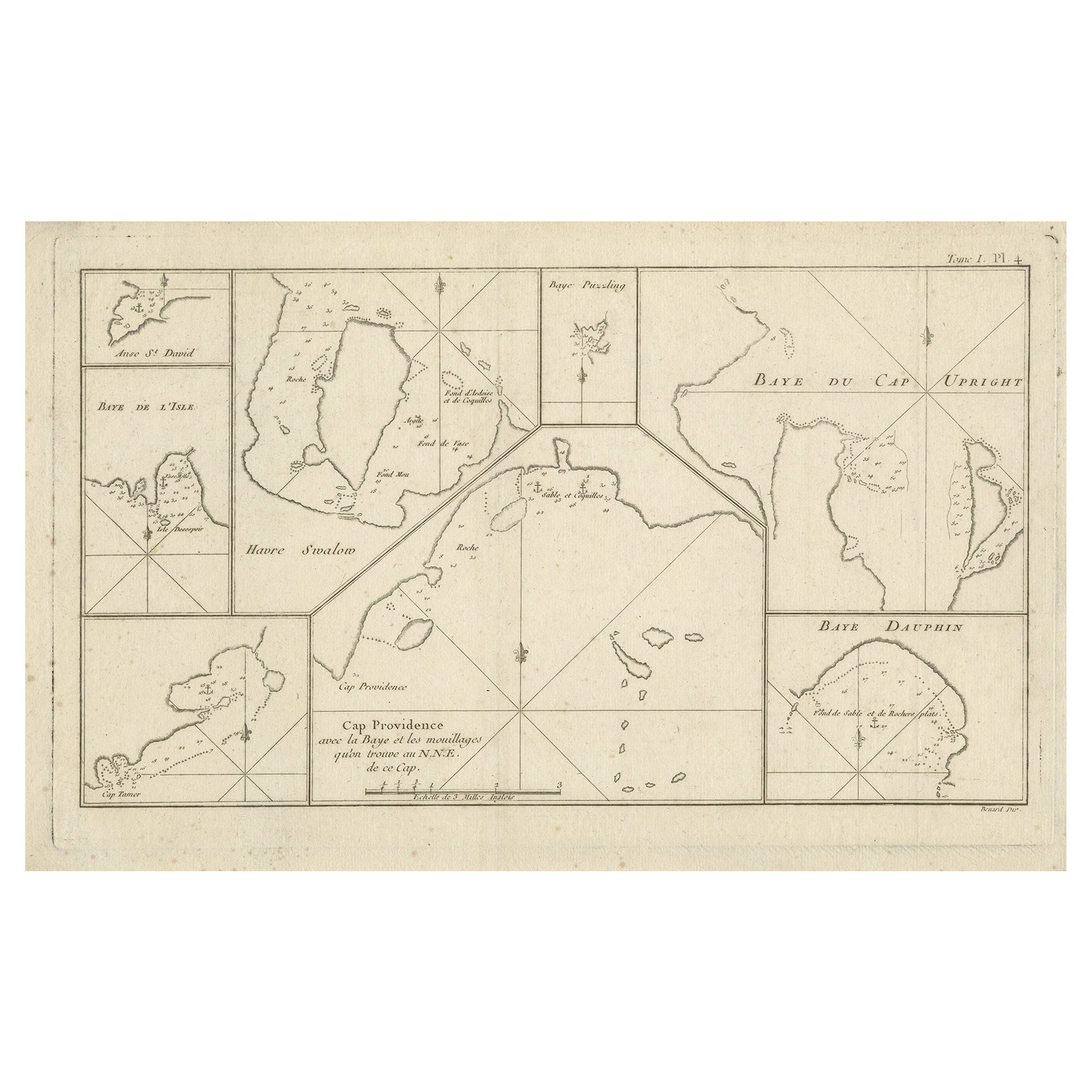
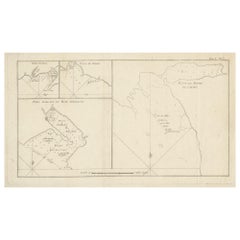
View AllAntique Map of CAP Providence, St. David
s Cove and Surroundings
Located in Langweer, NL
Antique map titled 'Baye du Cap Upright (..)'. Eight charts on one sheet of Cap Providence, St. David's Cove, the Bay of the Island, Swallow's Haven, Puzzlin...
Category
Antique Late 18th Century Maps
Materials
Paper
$345 Sale Price
20% Off
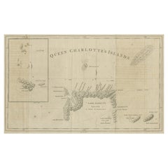
Map of Queen Charlotte
s, Carteret
s, Simson
s and Gower
s Islands, Canada, 1773
Located in Langweer, NL
Antique map Canada titled 'Queen Charlotte's Islands'.
Old map of Queen Charlotte's Islands, Canada. With an inset map of Carteret's, Simson's a...
Category
Antique 1770s Maps
Materials
Paper
Antique Map of the Islands Within the Queen Charlotte
s Islands
Located in Langweer, NL
Antique map titled 'Cote Septentrional de la plus grande des Isles de la Reine Charlotte (..)'. Map and coastal view of the islands within the Queen Charlotte's Islands (Santa Cruz I...
Category
Antique Late 18th Century Maps
Materials
Paper

$316 Sale Price
20% Off
Antique Map of the Friendly Islands by Cook, 1803
Located in Langweer, NL
Antique map Friendly Islands titled 'Kaart van de Vrienden Eilanden'. Antique map of the Friendly Islands depicting Rotterdam or Anamocka, Middelburg or Eaoowe and Amsterdam or Tonga...
Category
Antique 19th Century Maps
Materials
Paper

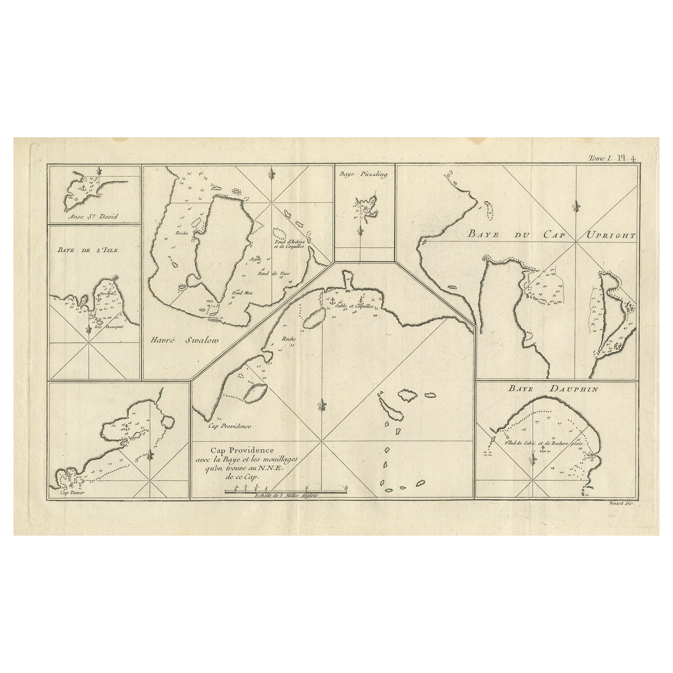
Antique Map of Cap Providence, St. David
s Cove and Surroundings
Located in Langweer, NL
Antique map titled 'Baye du Cap Upright (..)'. Eight charts on one sheet of Cap Providence, St. David's Cove, the Bay of the Island, Swallow's Haven, Puzzlin...
Category
Antique Late 18th Century Maps
Materials
Paper
$345 Sale Price
20% Off
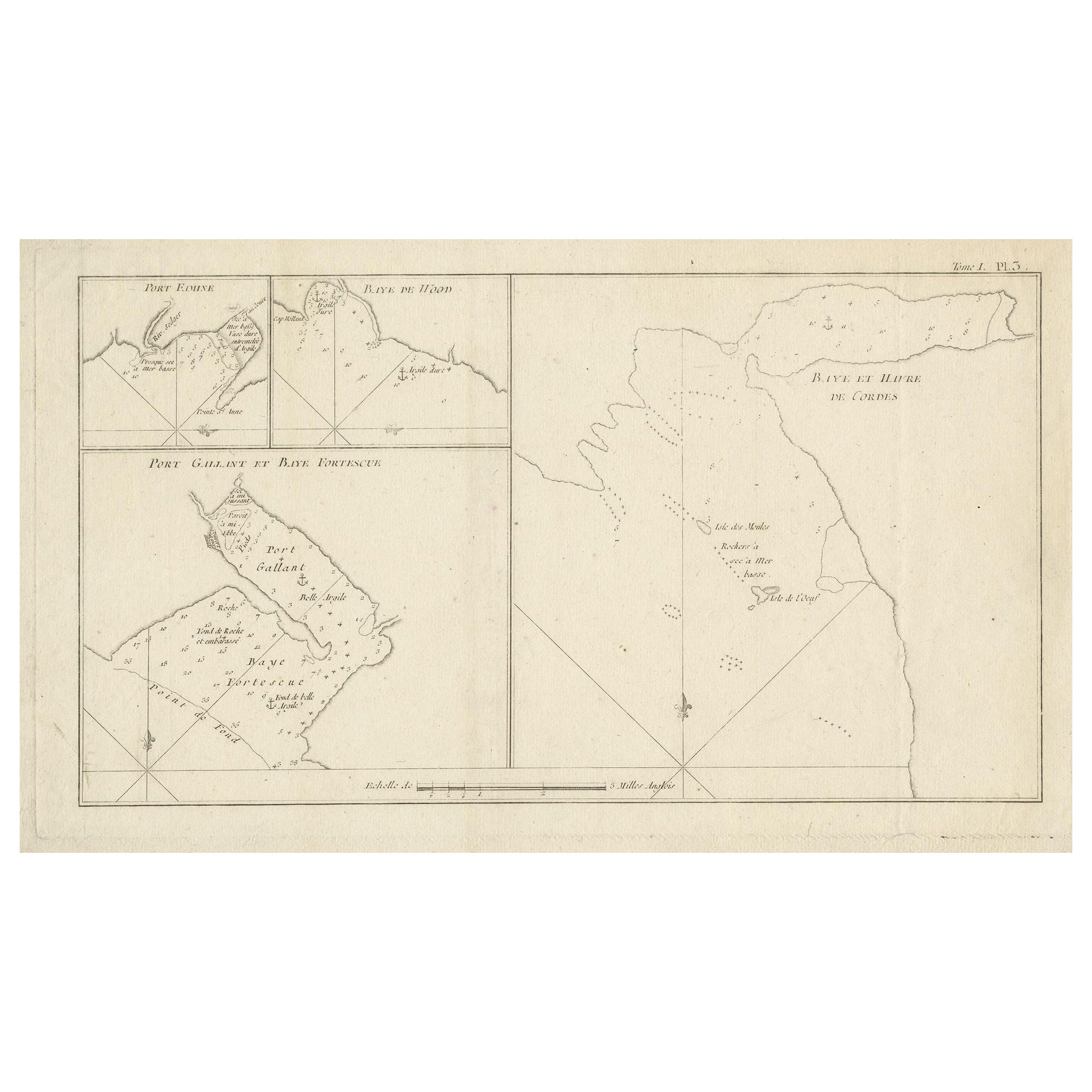
Antique Map of Cordes Bay and Surroundings
Located in Langweer, NL
Antique map titled 'Baye et Havre de Cordes (..)'. Four maps on the one sheet of; Cordes Bay, Port Famine, Woods Pay, Port Gallant, Fortescue Bay, Chile based on the voyage of John B...
Category
Antique Late 18th Century Maps
Materials
Paper
$249 Sale Price
20% Off
You May Also Like
Large Original Antique Map of The Canary Islands. 1894
Located in St Annes, Lancashire
Superb Antique map of The Canary Islands
Published Edward Stanford, Charing Cross, London 1894
Original colour
Good condition
Unframed.
Free shipping
Category
Antique 1890s English Maps
Materials
Paper

St. Christophe
St. Kitts
Island: An 18th Century Hand-colored Map by Bellin
By Jacques-Nicolas Bellin
Located in Alamo, CA
Jacques Bellin's copper-plate map of the Caribbean island of Saint Kitts entitled "Carte De De l'Isle St. Christophe Pour servir á l'Histoire Genle. des V...
Category
Antique Mid-18th Century French Maps
Materials
Paper

$460 Sale Price
20% Off
Original Antique Map of US Possessions In The Pacific Ocean, C.1900
Located in St Annes, Lancashire
Fabulous map of US possessions in the Pacific Ocean
Original color.
Engraved and printed by the George F. Cram Company, Indianapolis.
Published, C.1900.
Unframed.
Free shipping.
Category
Antique 1890s American Maps
Materials
Paper

West Coast of Africa, Guinea
Sierra Leone: An 18th Century Map by Bellin
By Jacques-Nicolas Bellin
Located in Alamo, CA
Jacques Bellin's copper-plate map entitled "Partie de la Coste de Guinee Dupuis la Riviere de Sierra Leona Jusquau Cap das Palmas", depicting the coast of Guinea and Sierra Leone in ...
Category
Antique Mid-18th Century French Maps
Materials
Paper

$460 Sale Price
20% Off
Large Original Antique Map of The Leeward Islands. 1894
Located in St Annes, Lancashire
Superb Antique map of The Leeward Islands
Published Edward Stanford, Charing Cross, London 1894
Original colour
Good condition
Unframed.
Free shipping
Category
Antique 1890s English Maps
Materials
Paper

Antique Map of California as an Island "The 5 Californias" by Robert de Vaugondy
Located in San Diego, CA
A very nice and rare antique map entitled "Carte de la Californie Suivant" (The 5 Californias), by Didier Robert de Vaugondy of Paris, circa 1772. The map itself measures 15.5" x 13...
Category
Antique Mid-19th Century American Maps
Materials
Paper

More Ways To Browse
Antique Hut
A La Reine
North Wind
New Hebrides
Antique Furniture Santa Cruz
Map Tuscany
St Eustatius
Sumba Map
Used Furniture Denver Co
Used Furniture Leominster
Vintage Long Island Map
Vintage World Map Desk
Vintage World Map Mirror
Antique Furniture Toledo Ohio
Antique Maps Washington Dc
Blaeu World Map
Cape Cod Map
F Colton