Items Similar to Antique Map of Schiermonnikoog, Wadden Island of the Netherlands, 1868

Want more images or videos?
Request additional images or videos from the seller
1 of 5
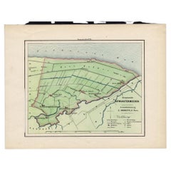
Antique Map of Schiermonnikoog, Wadden Island of the Netherlands, 1868
$237.36
$296.6920% Off
£177.05
£221.3220% Off
€200
€25020% Off
CA$330.36
CA$412.9520% Off
A$354.42
A$443.0320% Off
CHF 190.10
CHF 237.6320% Off
MX$4,267.18
MX$5,333.9820% Off
NOK 2,396.49
NOK 2,995.6120% Off
SEK 2,185.26
SEK 2,731.5820% Off
DKK 1,524.15
DKK 1,905.1920% Off
About the Item
Antique map titled 'Provincie Friesland - Gemeente Schiermonnikoog'. Map of the township of Schiermonnikoog, Friesland. This map originates from 'Gemeente-Atlas van Nederland' by J. Kuyper. Artists and Engravers: Published by H. Suringar.
Artist: Published by H. Suringar.
Condition: Excellent, given age. General age related toning and occasional light staining from handling as visible on image. Please study image carefully.
Date: 1868
Overall size: 26 x 19 cm.
Image size: 0.001 x 18.5 x 15 cm.
Antique prints have long been appreciated for both their aesthetic and investment value. They were the product of engraved, etched or lithographed plates. These plates were handmade out of wood or metal, which required an incredible level of skill, patience and craftsmanship. Whether you have a house with Victorian furniture or more contemporary decor an old engraving can enhance your living space.
- Dimensions:Height: 7.49 in (19 cm)Width: 10.24 in (26 cm)Depth: 0 in (0.01 mm)
- Materials and Techniques:
- Period:
- Date of Manufacture:1868
- Condition:Condition: Excellent, given age. General age related toning and occasional light staining from handling as visible on image. Please study image carefully.
- Seller Location:Langweer, NL
- Reference Number:Seller: PCT-158971stDibs: LU3054327619152
About the Seller
5.0
Recognized Seller
These prestigious sellers are industry leaders and represent the highest echelon for item quality and design.
Platinum Seller
Premium sellers with a 4.7+ rating and 24-hour response times
Established in 2009
1stDibs seller since 2017
2,830 sales on 1stDibs
Typical response time: 1 hour
- ShippingRetrieving quote...Shipping from: Langweer, Netherlands
- Return Policy
More From This Seller
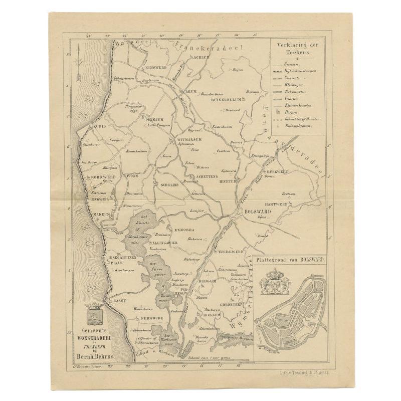
View AllAntique Map of The Wonseradeel Township in Friesland, The Netherlands, 1861
Located in Langweer, NL
Antique map titled 'Gemeente Wonseradeel'. Old map depicting the Wonseradeel township including cities and villages like Kimswerd, Achlum, Arum, Witmarsum, Kornwerd, Hichtum and Bols...
Category
Antique 19th Century Maps
Materials
Paper
$180 Sale Price
20% Off
Original Antique Map of Township Ulrum in Groningen, The Netherlands, 1862
Located in Langweer, NL
Groningen: Gemeente Houwerzijl-Niekerk-Vierhuizen-Ulrum-Zoutkamp. These scarse detailed maps of Dutch Towns originate from the 'Gemeente atlas van de Provincie Groningen in 62 kaarte...
Category
Antique 19th Century Maps
Materials
Paper
$151 Sale Price
20% Off
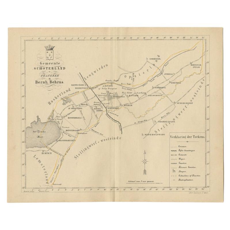
Antique Map of the Schoterland Township in Friesland, the Netherlands, 1861
Located in Langweer, NL
Antique map titled 'Gemeente Schoterland'. Old map depicting the Schoterland township including cities and villages like Rotsterhaule, Delfstrahuizen, Nieuweschoot, Mildam, Katlijk, ...
Category
Antique 19th Century Maps
Materials
Paper
$189 Sale Price
20% Off
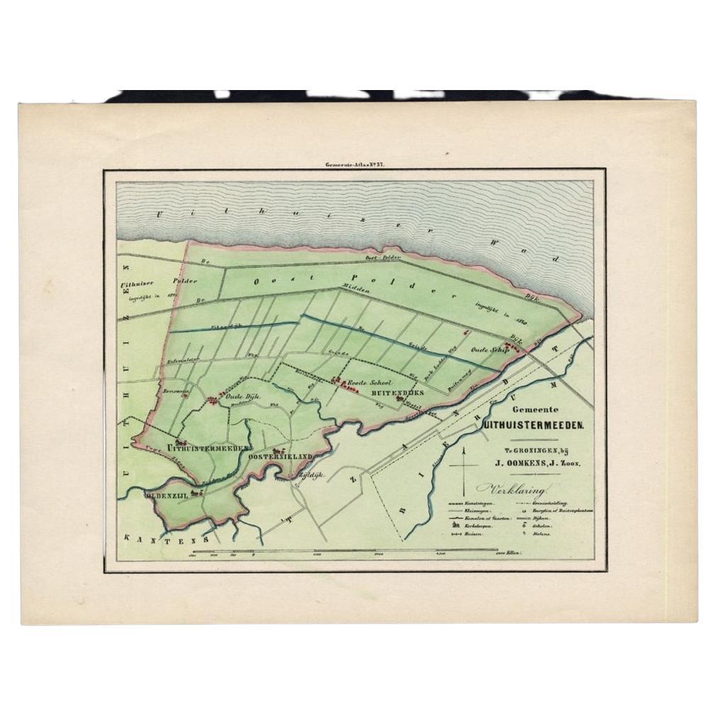
Original Antique Map of the Township of Uithuizermeeden, the Netherlands, 1862
Located in Langweer, NL
Groningen: Gemeente Oldenzijl-Oosternieland-de Roode School-Uithuizermeeden. These scarse detailed maps of Dutch Towns originate from the 'Gemeente atlas van de Provincie Groningen i...
Category
Antique 19th Century Maps
Materials
Paper
$151 Sale Price
20% Off
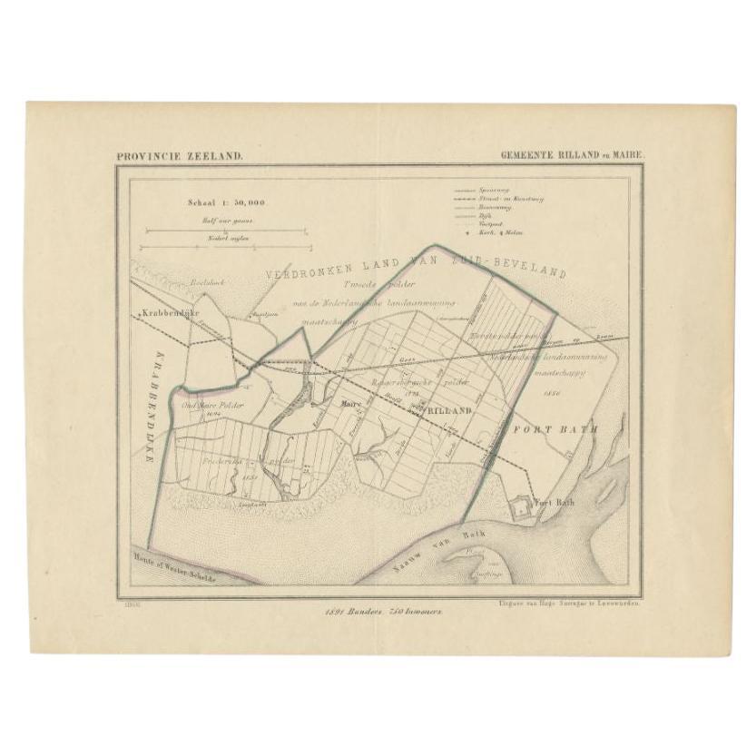
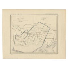
Antique Map of the Region of Rilland and Maire, Zeeland, the Netherlands, 1866
Located in Langweer, NL
Antique map titled 'Provincie Zeeland - Gemeente Rilland en Maire'. Original antique map of the region of Rilland en Maire, the Netherlands. This map originates from the 'Gemeente-At...
Category
Antique 19th Century Maps
Materials
Paper
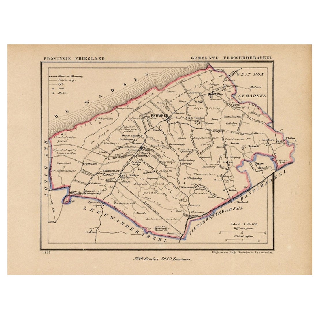
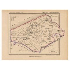
Antique Map of the County Ferwerderadeel, Friesland, The Netherlands, 1868
Located in Langweer, NL
Antique map titled 'Provincie Friesland - Gemeente Ferwerderadeel'. Map of the township of Ferwerderadeel including Ferwerd, Blija and many other villages. This map originates from '...
Category
Antique 19th Century Maps
Materials
Paper
You May Also Like
Large Original Antique Map of The Falkland Islands. 1894
Located in St Annes, Lancashire
Superb Antique map of The Falkland Islands
Published Edward Stanford, Charing Cross, London 1894
Original colour
Good condition
Unframed.
Free shipping
Category
Antique 1890s English Maps
Materials
Paper

1839 Map of Karte Des "Russischen Reiches in Europa Und Asien" Ric.R0013
Located in Norton, MA
1839 map of Karte Des
"Russischen Reiches in Europa and Asien"
Ric.r013
Map of the European and Asian parts of Russian Empire. Karte der Russischen Reiches in Europa und Asien...
Category
Antique 19th Century Unknown Maps
Materials
Paper

Large Original Antique Map of the The Windward Islands. 1894
Located in St Annes, Lancashire
Superb Antique map of The Windward Islands
Published Edward Stanford, Charing Cross, London 1894
Original colour
Good condition
Unframed.
Free shipping
Category
Antique 1890s English Maps
Materials
Paper

Large Original Antique Map of The Canary Islands. 1894
Located in St Annes, Lancashire
Superb Antique map of The Canary Islands
Published Edward Stanford, Charing Cross, London 1894
Original colour
Good condition
Unframed.
Free shipping
Category
Antique 1890s English Maps
Materials
Paper

Antique Lithography Map, Isle of Thanet, Kent, English, Cartography, Victorian
Located in Hele, Devon, GB
This is an antique lithography map of The Isle of Thanet in Kent. An English, framed atlas engraving of cartographic interest, dating to the mid 19th century and later.
Superb litho...
Category
Antique Mid-19th Century British Victorian Maps
Materials
Wood

Large Original Antique Map of The Leeward Islands. 1894
Located in St Annes, Lancashire
Superb Antique map of The Leeward Islands
Published Edward Stanford, Charing Cross, London 1894
Original colour
Good condition
Unframed.
Free shipping
Category
Antique 1890s English Maps
Materials
Paper

More Ways To Browse
1868 Furniture
Romania Map
Used Furniture Nova Scotia
18th Century Scottish Collectibles
Antique Furniture Northumberland
Antique Map Nova Scotia
Antique Map Palestine
California Island Map
Constantinople Map
Croatian Antiques
Jamaican Antique
Large Map Of Italy
Louisiana Antiques
Maps South East Asia
New Jersey Antique Furniture
Ptolemy Map
Antique Maps Massachusetts
Antique Maps Singapore